Historical Context
Southend takes its name from being a small fishing village located at the ‘south end’ of Prittlewell which has 6/7th century origins as a Saxon village. The finding of a Saxon King burial chamber nearby in 2003 illustrates the historical and archaeological importance of the area. Leigh to the west also has its origins as a Saxon fishing village and grew to become a prosperous port in the sixteenth century.
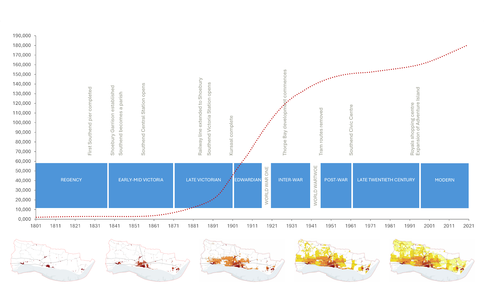
It was not until the late 18th century when sea bathing became fashionable and popular that some limited growth occurred along the foreshore at Southend with the Regency developments of Royal Hotel and Royal Terrace. In 1830 a wooden pier was constructed to receive sea passengers visiting the area which was later extended to reach deep-water. In 1891 the pier was reconstructed in iron and two years later its own railway was opened. The Pier remains the longest leisure pier in the world and the iconic face of Southend at the heart of its resort facilities.
The opening of the railway line from London Fenchurch Street to Southend Central in the 1850’s, followed by the line from London Liverpool Street to Southend Victoria in 1889, was the catalyst for rapid growth and saw Southend’s population increase significantly from under 10,000 in 1890 to 150,000 in the mid 1940’s.
The arrival of the railway in central Southend stimulated residential development including the laying out of Clifftown, and its distinctive Victorian large yellow stock brick buildings with Welsh slate roofs, together with Prittlewell Gardens, the first public park to be created in the city. To serve the increasing population, Southend’s retail centre developed between the two central railway stations and the Pier.
The mid to late Victorian period saw continued growth particularly to the north of Central station and to the east of Leigh on Sea. Larger villas were built often individualistic with corner turrets, employing a wide range of building materials together with larger areas of terraced housing based on regular grids.
In the east of the city the British School of Gunnery was opened in 1848 in Shoeburyness with associated barracks and the railway line extended from central Southend to serve the area some thirty years later. This stimulated residential and commercial development in the adjoining area. The Shoebury Garrison remained in military use until 1976 when it was disbanded. The site was eventually sold in 2000 for development when it was converted into predominantly residential use and now forms the historic Garrison conservation area with the adjacent Gunners Park and part of the historic High Street in Shoebury. The military establishments at New Ranges in north Shoebury and adjoining Foulness remain.
The coming of the railway also saw the growth in popularity of Southend as a traditional seaside resort and the development of hotels and tourist facilities, most notably the commanding Palace Hotel overlooking the Pier and the nearby Kursaal theme park, one of the world's first purpose-built amusement parks. The popularity of water recreation also saw the emergence of the first yacht clubs in Southend which remain a prominent feature on the foreshore.
At the turn of the century the Edwardian period was one of the most prolific in terms of Southend’s growth with the expansion of Leigh on Sea up to the London Road and in Westcliff, Westborough and the southern part of Prittlewell. The initial development of areas of Southchurch, both to the north of the railway line and along the seafront also took place. Areas of planned street network, either on a regular grid or flexible grid, were built out by a wide range of developers.
This expansion of the urban area promoted the establishment of shopping centres at Leigh, Westcliff and Southchurch to serve the needs of the growing population. Hamlet Court Road shopping area in Westcliff became a fashionable retail area and is thought to have been known as the ‘Bond Street’ of Southend.
The national recognition of the benefits to health of providing parks in urban areas saw the establishment of such facilities in Southend in the early to mid-1900’s to serve the needs of a growing local population. The first parks came into being through a combination of philanthropy and acquisition, namely Priory Park, Southchurch Park, Chalkwell Park, Southchurch Hall Gardens, Belfairs Park and Nature Reserve, Shoebury Park and Eastwood Park. These remain the principal parks in the city and provide valuable green lungs and recreational space within the urban area.
In the inter-war period there was a significant push to build new areas of housing, and the public housing programme grew significantly. Development took place in Leigh and Southchurch together with the early phases of Thorpe Bay. The classic house of this period was the semi-detached with wider and squatter proportions than its Edwardian and Victorian predecessors. Thorpe Bay was laid out in a grid drawn to generous proportions with wide plots and very large Edwardian and interwar houses as well as a substantial phase of post war bungalows and houses.
In 1935 Southend Airport to the north of the town was officially opened as a municipal airport having first been used as an airfield by the Royal Flying Corps during World War I before reverting to farmland. The Airport grew to be London's third-busiest airport from the 1960s until the end of the 1970s after which it declined in use until its more recent redevelopment which saw a resurgence in its use and popularity.
As with the period following the First World War the decade after the Second World War lent renewed vigour and urgency to house building. Initially, for speed a number of pre-fabricated building systems were developed to enable homes to be erected on site as quickly as possible. Examples of these are still evident in Southend. However, conventional brick-built houses very quickly became the norm again, accounting for large areas of new development which owe much to the earlier garden city style housing for their design and planning influences.
The key infrastructure addition during this period was the development of the A127 as a dual carriageway, providing a new focus for development and particularly industrial and business development, in the northern part of the city. The increase in car ownership and relative ease of access across the north of the Borough promoted suburban housing developments at Eastwood and Shoeburyness.
The post war period was a boom period in terms of tourism with large numbers of people visiting Southend, some two and a half million people used the Pier in 1950. Although numbers declined in the 1960’s with the introduction of cheaper holiday destinations abroad, Southend has retained its status as a major resort destination witnessed by the expansion of Adventure Island theme park adjacent the Pier in the 1990’s and by numerous recent hotel and leisure developments.
The 1960’s saw significant redevelopment in the town centre to accommodate the car and provide for new shopping and employment facilities. Victoria Avenue was developed as a gateway to the town centre with large office blocks, civic area and educational establishments, and the Victoria Shopping Centre and multi storey car parks developed. The High Street was one of the first to be pedestrianised in the country. Tall buildings set within areas of landscape were built as part of public housing projects. The Royals indoor shopping centre was developed at the southern end of the High Street in the late 1980’s.
In the face of large redevelopment schemes across the country, in 1967 the Government of the day introduced Conservation Areas to protect areas of special architectural or historic interest. The ability to protect individual historic or architecturally important buildings by ‘listing’ them, had been introduced after the second world war. Southend now has 16 conservation areas and numerous listed buildings spread across the city.
Increased emphasis from central government on allowing out of town shopping areas through the 1980’s and 90’s resulted in new large supermarket outlets and retail areas being established mainly to the north and east of Southend.
All these developments gave the city its current urban form. To safeguard the surrounding areas of open countryside from urban sprawl and coalescence with neighbouring settlements, the majority of the open countryside was designated in the late 1980’s as forming part of the wider Metropolitan Green Belt stretching from east London across south Essex.
More recent development has seen a return to more clearly defined urban forms which relate to conventional street patterns, often using modern materials. There has also once again been a focus on town and city centres, with higher density development and sustainable models of living.
Figure 2.1 provides an overview of Southend’s urban/ population growth.
Southend Today - context and issues
About Southend – Southend’s administrative boundary tightly abuts the existing urban area, and the surrounding open countryside is designated as forming part of the wider Metropolitan Green Belt stretching from east London across South Essex. These factors mean that land resources in the city are extremely limited and provides for a significant planning challenge in seeking to meet future development needs, particularly for housing, whist safeguarding the character and natural amenities of the area. Being located on a peninsula, the geography of the area dictates the surface transportation links to the city which are concentrated in a narrow east-west corridor which present congestion and accessibility issues affecting the local economy and tourism industry.
A CITY BY THE SEA
Strategy and Objectives – sustainable growth that contributes to future needs whilst protecting and safeguarding the character and natural amenities of the City requires the development of a comprehensive strategy and objectives which underpin the principles and policies of the Plan.
c.
Securing and Improving Infrastructure – it will be essential that the social and physical infrastructure is secured to meet the needs of a growing population. Education, health, sewage and drainage, and highway infrastructure is already struggling to cope with demand. Further developments need to be carefully planned to ensure that the necessary infrastructure is in place to meet the increasing cumulative demands. This document therefore seeks to adopt an ‘infrastructure led’ approach.
d.
The option of providing a new neighbourhood on land north of Southend - due to this significant under-provision in new homes, the Local Plan must consider the possible designation of land designated as Green Belt for residential mixed-use development in line with national planning policy.
A CITY THAT IS HEALTHY AND SAFE
Enabling Healthy Lifestyles & Wellbeing – There are health inequalities across Southend often exceeding the national average. It will be essential that new development embraces the principle of facilitating healthy lifestyles through promoting walking and cycling and the provision of sport, recreation and green space facilities. The concept of facilitating complete neighbourhoods across the city, where everyday essentials and services are within a convenient walking distance, will help promote healthy lifestyles.
A CITY OF OPPORTUNITY
Homes - the city has grown into a substantial residential area comprising 83,500 dwellings, providing homes for 182,000 people. This has resulted in the city having one of the highest residential densities in the UK outside London. The Government Standard Method for calculating housing need indicates that 1,405 new homes are needed each year in Southend. Recent housing provision has been concentrated on brownfield sites mainly in the central urban areas with a large proportion of flatted developments. In the City Centre conversion from obsolete office blocks to residential have provided a significant stock of accommodation. However, this provision has not kept pace with demand particularly for affordable and family housing.
Securing a Thriving Local Economy – the local economy is dominated by small to medium enterprises with 86% of companies employing 10 staff or fewer. There are approximately 80,000 jobs in Southend provided in a variety of commercial areas and designated business estates. There is a need to provide around 450 additional jobs per annum with opportunities for growth in several sectors, including construction, aviation, health industries, tourism and leisure, and business and financial services. It will be essential that the Plan embraces this potential and satisfactorily accommodates the trend for increased working from home and the need for digital infrastructure. The City Centre, London Southend Airport and associated business park, and a cluster of existing employments areas located along the A127/A1159 corridor are well placed to achieve economic growth. It will also be important that education and further education is facilitated capitalising on the city’s university campus and apprenticeships and building the skills base.
Tourism – Southend is a major UK resort and attracts around 7 million day visitors and over 200 staying visitors each year which enrich the local economy. There is significant potential to maximise Southend’s potential as a visitor destination and resort, particularly in terms of the evening economy and through encouraging overnight and longer stays by capitalising on the resort’s success as a day visitor destination. Managing these visitor numbers in a sustainable way will need to be addressed by the Plan, having regard to access and visitor parking.
A CITY TO BE PROUD OF
Urban Design, Character and Heritage – with limited land resources, areas of high urban building densities and an established local character, quality design and layout will be an important ingredient in new development schemes in seeking to protect the unique character of areas and their sense of place to provide attractive environments where heritage is celebrated and recognised for the role it can play in place making and regeneration.
A CITY THAT IS GREEN AND SUSTAINABLE
Enhancing our Natural Environment – with seven miles of foreshore and over 500 hectares of green space, the city has a rich and varied landscape providing for recreation and important wildlife habitats and green lungs within the densely developed urban area. It will be essential that the foreshore and green spaces are protected, and biodiversity is enhanced within an improved network of green corridors.
Climate Change and Environmental Protection – all development and future proposals will need to address the challenges of climate change and flood risk, including energy efficiency. Southend is susceptible to local water surface flooding under conditions of extreme rainfall and from tidal flooding in certain locations. It is essential that these issues are properly managed and planned and that sustainable drainage systems are incorporated into development schemes.
A CITY THAT IS CONNECTED AND SMART
Transport and Connectivity – the city is served by two railway lines and two highway arteries (the A127 and A13) within a confined east - west corridor to London. Reliability and congestion issues can have major impacts on the local economy and its tourism offer. It will also be important for the Plan to embrace sustainable transport provision, including the bus, cycling and walking particularly for short journeys, whilst recognising the important role that the private car has to play in the local economy, particularly for tourism.
London Southend Airport – Following the impacts of Covid-19 the Airport is in a state of recovery and it is likely to take several years to return to pre-pandemic levels. Any further growth will need to be carefully managed in association with all relevant partners to ensure that growth takes into full account environmental considerations, particularly those relating to noise and surface access. The Airport Business Park continues to provide a significant opportunity for new employment floorspace and jobs.
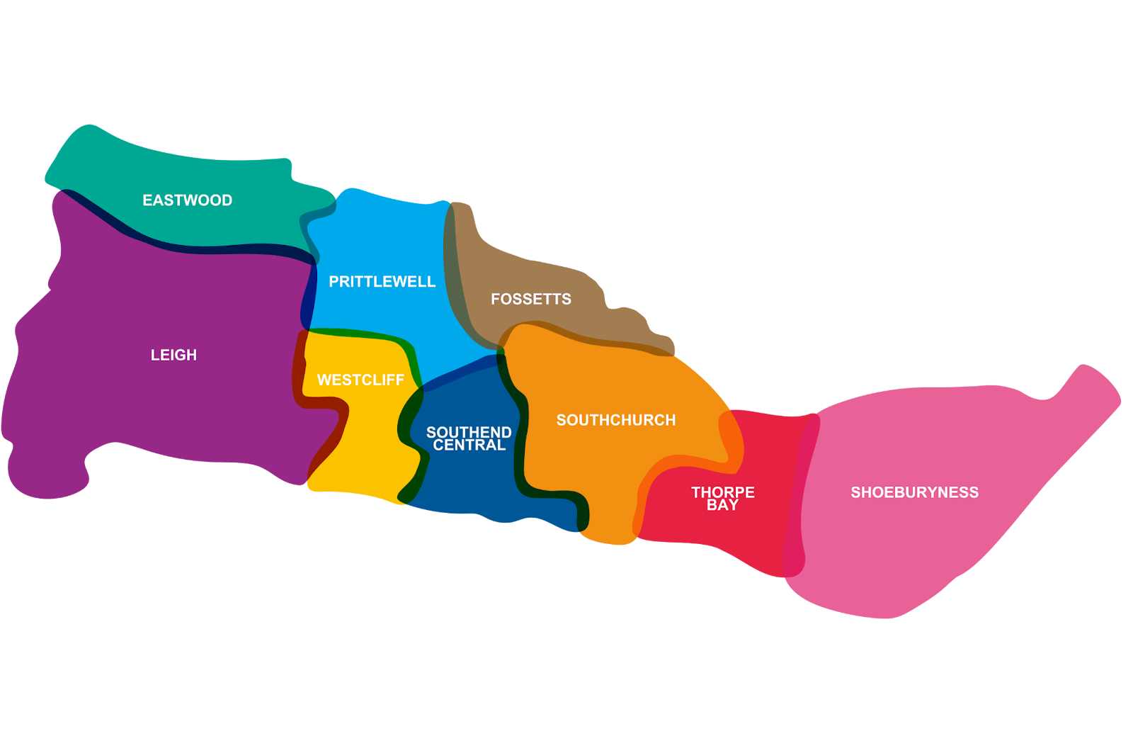
THE NEIGHBOURHOODS OF SOUTHEND
Place Specific Policies – Southend has grown organically from the villages of Leigh, Prittlewell and Shoeburyness to form a cohesive urban area comprising distinct neighbourhoods (see Figure 2.2). It will be important that this local distinctiveness and character is recognised and respected in future development schemes. It will also be important for the Plan to address the changing role of the retail and commercial centres within the neighbourhoods, particularly in the City Centre. The City Centre has been greatly impacted by the changing shopping patterns of customers with the advent of on-line shopping and the demise of a number of prominent national retail outlets.
Figure 2.2: The Places of Southend
(Southend Neighbourhoods)