The ‘Preferred Approach with Options’ document poses a question on whether to develop a new comprehensive neighbourhood on Green Belt land north of Southend. It is identified as an ‘option’ and comments are invited as part of the consultation as to whether the land should be allocated for development purposes or retained within the Green Belt.
To support the Government’s objective of significantly boosting the supply of homes it is important that sufficient land is identified where it is needed through the plan making process.
Local Plans should be positively prepared seeking to meet objectively assessed needs. National planning policy dictates that housing need should be calculated using the national Standard Method. To 2040 housing need in Southend conducted using the national Standard Method is nearly 24,000 (or 1,405 homes per annum). This is more than 4 times recent delivery rates.
Draft Strategic Policy SP2 (Spatial Strategy) makes provision for at least 9,500 homes (around 550 homes per annum) that could be sustainably accommodated within the existing urban area of Southend outside the Green Belt and at Fossetts Farm by 2040. However, this results in a shortfall of over 14,000 new homes over this period compared to the national Standard Method for calculating housing need.
Due to this significant under-provision in new homes the Local Plan must consider the possible designation of land designated as Green Belt for development in line with national planning policy. Land within the Green Belt to the north of Southend straddling the administrative boundary with Rochford District is being promoted by developers. Such development could provide for a mix of new homes, commercial floorspace, strategic parkland and new infrastructure and services to support a new neighbourhood. However, it would still not meet housing need as calculated by national Standard Method for Southend.
National planning policy sets out that Local Plans should make provision for local housing needs (conducted using the national standard method) unless areas protected by the National Planning Policy Framework* provides a strong reason for restricting development in the area or any adverse impacts would significantly and demonstrably outweigh the benefits.
The ‘Rochford District and Southend on Sea Joint Green Belt Study’ undertaken in 2020 identifies the majority of Green Belt land to the north of Southend as continuing to serve the stated purposes of the Green Belt well, in particular by maintaining the openness of the countryside. The majority of the agricultural land to the north of Southend is also considered as high-grade quality.
Having regard to the above considerations, the main issue concerning the future designation of land north of Southend in this Local Plan is whether:
- the land north of Southend performs its Green Belt function well, in accordance with the stated purposes of the Green Belt as set out in the NPPF, and alterations would fundamentally undermine the purposes (taken together) of the remaining Green Belt such that it warrants retention of its Green Belt Status; or
- the outstanding identified housing need in Southend is such that it justifies exceptional circumstances to be applied in reviewing the Green Belt boundaries and that land north of Southend be designated for development purposes.
If the latter is considered appropriate, it is important that transport impacts arising from the development can be successfully mitigated**, and along with other infrastructure requirements, including education and health, be funded and delivered at pace to ensure any new development is sustainable and its community can thrive.
* The policies referred to are those in the NPPF relating to: habitats sites and/or designated as Sites of Special Scientific Interest; land designated as Green Belt, Local Green Space, a National Landscape, a National Park (or within the Broads Authority) or defined as Heritage Coast; irreplaceable habitats; designated heritage assets (and other heritage assets of archaeological interest referred to in footnote 75); and areas at risk of flooding or coastal change.
** National Planning Policy states that development should only be prevented or refused on highways grounds if there would be an unacceptable impact on highway safety, or the residual cumulative impacts on the road network, following mitigation, would be severe, taking into account all reasonable future scenarios.
Previous Local Plan consultations
In seeking to meet the national housing need figure for Southend, the two previous Local Plan consultation documents (the ‘Issues and Options’ and ‘Refining the Plan Options’) identified possible strategic options, namely:
- Option 1 - all development provided within existing urban areas;
- Option 2 - (including Option 1) most development provided within existing urban areas with some development on the urban edges on greenfield and agricultural land; and
- Option 3 - (including Option 1 and 2) and the potential provision of a new neighbourhood on predominately agricultural land, designated as Green Belt, to the north of the city with the possible potential to work with neighbouring Rochford District Council to develop a more comprehensive cross-boundary new settlement/s, subject to the outcome of detailed green belt studies.
Comments received on the possible development of Green Belt land as part of Option 3 were mixed. Whilst it was recognised that the land offered the opportunity for significantly contributing towards meeting projected housing needs and thereby ease housing pressures, it was recognised by a number of residents that it would result in the irreversible loss of the only extensive area of open countryside and Green Belt land in the city, contrary to the stated purposes of the Green Belt and would lead to the loss of agricultural land and mineral resources.
A potential new neighbourhood in the Green Belt - promoted by developers
Land designated as Green Belt to the north of Southend traversing the administrative boundary with Rochford District is being promoted by developers as part of the Local Plan preparation process to Southend City and Rochford District Councils for strategic scale development (Figure 3b.1). Such development could provide for a mix of new homes and new infrastructure to support a new neighbourhood. This could include a new highway access route linking to the strategic highway network and a new Country Park facility aligning the River Roach, but such provision would be dependent on land within the Rochford district. In support of this a ‘Proof of Concept’ has been provided by land promoters, which was published alongside the ‘Refining the Plan Options’ Local Plan document. This provided a ‘developer’ led view on one way in which the strategic scale new neighbourhood could come forward (available on the Councils website here).
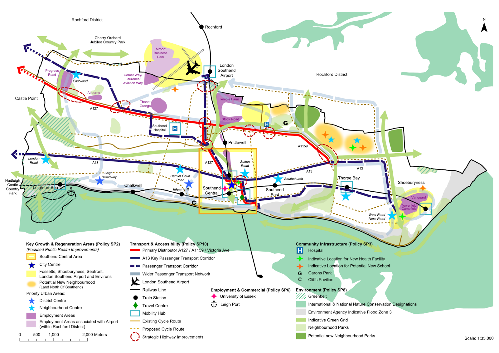
Figure 3b.1: Land designated as Green Belt in Southend being promoted for development

What a new neighbourhood on land designated as Green Belt in Southend as promoted could deliver
The land to the north of Southend within the Green Belt being promoted to the Southend Local Plan equates to 288 hectares. Development of this land in isolation from land within the administrative district of Rochford could deliver (Figure 3b.2):
- around 4,000 – 5,000 new homes of mixed size and type to include a high proportion of family and affordable housing*;
- supporting uses, including employment provision, health, school and community facilities;
- a network of formal green and blue Infrastructure such as public open spaces, sport, recreation and community space;
- the provision of sustainable urban drainage, landscaping and biodiversity measures; and
- new transport links and pedestrian and cycle connections and bus priority measures.
* A similar amount of new homes could be delivered within Rochford District as part of an expanded series of new neighbourhoods to the north of Southend. This will be considered as part of the Rochford District Local Plan.
A new neighbourhood could be linked by a new multi-modal transport corridor. The corridor could feature varied open spaces acting as the central spine of the development, connecting to existing rail stations, the City Centre and the wider strategic transport network. Several new communities and centres would be arrayed along this central spine.
It should be noted that a new transport corridor, linking the new neighbourhood to the strategic highway network, would be dependent on land within the Rochford District being incorporated within the scheme. Delivery of such requisite transport improvements would therefore be dependent on the co-operation of Rochford District Council as the Local Planning Authority and Essex County Council as the highway authority.
The development of land north of Southend would be able to accommodate a range of housing needs, including the delivery of much needed family and affordable housing, but would still not meet the national Standard Method for calculating housing need for Southend. Neighbouring local authorities have continually been engaged about the constraints Southend faces and whether they would be able to make a contribution to Southend’s unmet housing needs. However, all have indicated that they are similarly constrained and therefore unable to accommodate any requests from Southend, except Rochford District Council who are unable to confirm their position, as they are yet to reach the point of making strategic decisions in regard to their spatial strategy and where housing growth could sustainably be accommodated in the District.
Green Belt
The development of land north of Southend would also result in the irreversible loss of designated Green Belt land and agricultural land. National Green Belt planning policy is set out within the National Planning Policy Framework (NPPF).
“The Government attaches great importance to Green Belts. The fundamental aim of Green Belt policy is to prevent urban sprawl by keeping land permanently open; the essential characteristics of Green Belts are their openness and their permanence” (NPPF para. 142). The guidance provides that a change to Green Belt boundaries should only be made through the Local Plan process where exceptional circumstances are fully evidenced and justified (NPPF para. 145). “Exceptional circumstances in this context include, but are not limited to, instances where an authority cannot meet its identified need for homes… if that is the case, authorities should review Green Belt boundaries in accordance with the policies in this Framework and propose alterations to meet these needs in full, unless the review provides clear evidence that doing so would fundamentally undermine the purposes (taken together) of the remaining Green Belt, when considered across the area of the plan” (NPPF para. 146).
The Rochford District and Southend on Sea Joint Green Belt Study* identifies that the majority of Green Belt land to the north of Southend as continuing to serve the stated purposes of the Green Belt** well, in particular by maintaining the openness of the countryside. The study notes that the release of the Green Belt land for a new neighbourhood within Southend would:
- represent significant urban sprawl northwards of Royal Artillery Way and the A13 onto Green Belt which is typically open and has a strong relationship with the wider countryside
- diminish the ‘gap’ between Southend with the inset villages of Great and Little Wakering to the east and create a more irregular Green Belt boundary when compared to the existing strong boundary;
- weaken the integrity of the neighbouring Green Belt to the north of the city within Rochford; and
- result in a predominantly ‘high harm rating’*** to the Green Belt, the harm generally increasing the greater the area of release, i.e. the further away from the existing urban edge the new Green Belt boundary is located.
* Rochford District and Southend on Sea Joint Green Belt Study, LUC, London, February 2020 Rochford District and Southend-on-Sea Borough Joint Green Belt Study
** The Green Belt serves five purposes as set out in the NPPF (paragraph 143):
- to check the unrestricted sprawl of large built-up areas;
- to prevent neighbouring towns merging into one another;
- to assist in safeguarding the countryside from encroachment;
- to preserve the setting and special character of historic towns; and
- to assist in urban regeneration, by encouraging the recycling of derelict and other urban land.
*** Joint Green Belt Study 2020 – Definition of High Harm Rating: ‘Where land makes a relatively strong contribution to multiple Green Belt purposes and where its release would weaken the adjacent Green Belt (for example by leaving a narrow gap between towns, or increasing its containment by urban areas), harm is likely to be high’.
The agricultural land to the north of Southend is predominantly graded as being of Grade 1 quality in the ‘Agricultural Land Classification’ (ALC)*. The National Planning Policy Framework recognises the economic and other benefits of the best and most versatile agricultural land (paragraph 180) whilst the Government’s 25-year plan** to improve the environment seeks to protect the best agricultural land and put a value on soils as part of our natural capital. Existing policy seeks to safeguard areas of quality agricultural land.
* Agricultural Land Classification is a system used in England and Wales to grade the quality of land for agricultural use. The system classifies land into five grades. Grades 1, 2 and subgrade 3a are considered within the ‘best and most versatile’ land category in the current planning system.
** A Green Future: Our 25 Year Plan to Improve the Environment – Department for Environment, Food and Rural Affairs, February 2023.
In addition, there are also mineral deposits on land north of Southend and existing policy seeks to safeguard these deposits from proposals that would result in the permanent sterilisation of workable or potentially workable brickearth deposits unless it can be demonstrated that the deposits are currently not commercially viable.
The NPPF* also provides that in reviewing Green Belt land to meet their own housing need, Councils should give priority to previously developed land within the Green Belt and then consider ‘grey belt’ land that does not strongly contribute to any of three of the five stated purposes of the Green Belt, namely a) to check the unrestricted sprawl of large built-up areas; b) to prevent neighbouring towns merging into one another or d) to preserve the setting and special character of historic towns (see footnote 7 above). Such provisions exclude certain areas such as those at risk of flooding or designated heritage assets. Given that land north of Southend is predominantly in agricultural use and that the findings of the Rochford District and Southend on Sea Joint Green Belt Study found that the land continues to serve the stated purposes of the Green Belt well, particularly in relation to criteria a), checking the unrestricted sprawl of the Southend urban area, it is considered that the ‘grey belt’ definition does not apply in these circumstances.
* National Planning Policy Framework (NPPF, December 2024, paragraph 148 and Annex 2, Glossary).
Summary
To facilitate the delivery of a new neighbourhood, a range of complementary services and other uses would be required, including but not limited to improved transport and access, new schools, health facilities, parkland and green space and other supporting infrastructure. The pros and cons of a new neighbourhood on Green Belt land north of Southend are summarised in Table 3b below.
Table 3b: Summary - Positive impacts and potential harm of a new neighbourhood within Southend on land designated as Green Belt
Positive Impacts
- Provision of a thriving new community on land to the north of Southend providing a significant number of new homes (4,000 – 5,000 homes within Southend)* that could help ease local housing pressure.
- Provide new education, health and community services and facilities within easy reach of new homes.
- Provision of new transport corridor and other connections for walking and cycling, public transport and private motor vehicles.
- Provision of new public open spaces and new Country Park. Enhance biodiversity across the area through planting and establishing new and improved green spaces.
- Will comprise a high proportion of new affordable homes.
- Provision of a high proportion of much needed family housing.
- Attract significant investment and new jobs to Southend during construction phase
- Provision of new local centres and commercial premises.
- Capacity for development to provide a more cohesive landscape character, particularly around Fossetts Way/ Garon Park.
Potential Harm
- Loss of Green Belt, countryside and openness around Southend. Potentially weaken Green Belt to the north of Southend and ability to check urban sprawl.
- Would still not meet Southend housing needs in full over the plan period.
- Delivery of requisite transport corridor and link road would need to be provided upfront and reliant on land within Rochford District and the support of Rochford District Council and Essex County Council.
- The extent of a new Country Park would be dependent on land within Rochford District.
- Would result in the permanent loss of agricultural land in this locality.
- Would likely result in the sterilisation of mineral deposits (brickearth) subject to prior subtraction.
- May direct investment away from the existing urban area and undermine regeneration, potentially in Southend City Centre
- Delivery would take many years and may disrupt existing communities.
- Risk of reducing clear separation between distinct characters of urban Southend and village of Great Wakering and ability to prevent their mergence.
* A similar amount of development could be provided within Rochford, subject to the preparation of the Rochford Local Plan.
Have your say…… Please explain your answers
Do you think land north of Southend currently designated as Green Belt should be:
a) allocated for mixed-use residential-led development, including new parkland and associated services and infrastructure to contribute to meeting identified housing needs; or
b) retained as Green Belt?
If you answered ‘Yes’ to Q3b.1.a, do you think that:
a) Green Belt land north of Southend should only be released in conjunction with adjoining land within the Rochford District to provide for a comprehensive new neighbourhood and new highway access to the A127, or
b) Green Belt land north of Southend should be released for housing development regardless of whether adjoining land within the Rochford District is made available? (this could preclude the provision of a new highway linking to the existing strategic road network and the provision of a new Country Park facility).
Guiding Principles and Expectations for a possible new neighbourhood on land north of Southend
If it is deemed appropriate to pursue the provision of a new neighbourhood on Green Belt land north of Southend following this stage of Local Plan consultation, it will be important to incorporate a Strategic Policy in the next stage of Local Plan preparation, setting out guiding principles and expectations to guide the new development scheme.
We need your views on what policy criteria should be included to guide the design of a new neighbourhood if this option is in the next stage of the Local Plan.
Strategic Policy Option 3b below sets out the range of different land uses, services and facilities that would be needed for a new neighbourhood to be sustainable, vibrant and thrive. Figure 3b.3 provides a guide for the proportion of land given over to certain uses.
For example, 50% of the land being promoted would be expected to be Green and Blue Infrastructure. This includes a wide range of features, such as parks, open spaces, playing fields, allotments, woodland, road verges and water features, sustainable drainage, lakes and ponds. This does not comprise private/ communal residential gardens or green roofs and walls (as these are included within the residential parcel area calculation).
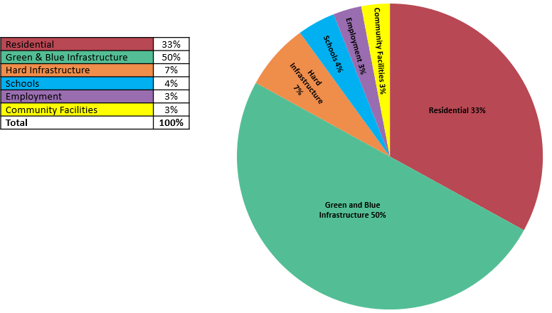
* Southend Land Budgets in Large Scale New Developments. Sets out benchmarks for land use budgets based on 16 examples of large-scale developments.
3b. Strategic Policy Option: Guiding Principles and Expectations for a possible new neighbourhood on land north of Southend
- The strategy option should provide for a vibrant new community, including between 4,000 – 5,000 new homes, employment floorspace, new parkland and associated infrastructure and services on land to the north and within Southend. This could form part of a wider proposal on adjacent land within Rochford District.
- Developers must produce a Strategic Master Plan, which is in general conformity with the adopted Local Plan and any supplementary planning documents, in partnership with the Council and other stakeholders, such as Rochford District Council, Essex County Council, the local community, infrastructure providers and statutory bodies.
- Infrastructure, including social infrastructure, must be plan led and delivered at a pace which meets the needs of the proposed development throughout the construction of the site. Developers will be expected to contribute to the provision of strategic highway and other infrastructure requirements set out in the Infrastructure Delivery Plan. This includes, but not limited to:
- provision of strategic parkland and an integrated network of Green and Blue Infrastructure, such as public open spaces, sport, recreation and community space, allotments, sustainable urban drainage, landscaping and biodiversity measures having regard to the South Essex Green and Blue Infrastructure Study (SEE Park).
- provide highway solutions to address the impact on the wider strategic road network, including junction and capacity improvements and the provision of a new multi-modal transport corridor linking the new neighbourhood to the strategic highway network (A127). Parts of the new corridor would be located within the Rochford/Essex administrative area. The design and development of the route will therefore need to be progressed collaboratively.
- include the provision of walk/ cycle/ bus/ car access throughout the site and ensure the successful integration with the existing transport network with a particular focus on direct and convenient access to the City Centre and nearby train stations, including London Southend Airport train station.
- provide a broad range of health care facilities including GP’s and enhancing community health infrastructure and acute care facilities.
- provision of education facilities (estimated to include one primary school and one through school) together with childcare and Early Years.
- multi-purpose community space and facilities, including space for creative industries, youth services and play equipment.
- satisfactory water supply and wastewater network infrastructure improvements for occupants.
- The development must:
- provide sustainable, integrated and well-planned development that reflects the overarching principles of the Southend Local Plan and supplementary design guidance for the area and incorporate a broad range of uses, infrastructure, public green space and services and a new Country Park facility having regard to Figure 3b.3.
- be designed sensitively to take full account of topography and landform and to successfully integrate with the existing urban areas of Southend.
- provide a range of high-quality new homes of mixed size and type, including a high proportion suitable for families and 40% affordable housing.
- include appropriate retail and town centre uses to support the local population, through the provision of high-quality walkable local centres, incorporating an element of employment floorspace targeted at small and medium enterprises.
- provide opportunity for local jobs, skills and training during development.
- be energy efficient achieving Net Zero carbon in operation (in line with Option 2 within draft Policy DM9.1)
- provide sustainable drainage solutions and flood mitigation measures and be flood resistant and resilient.
- deliver an overall net gain of at least 10% for biodiversity in line with Policy DM8.5
- provide and contribute to public art within the development.
- include measures necessary to safeguard wildlife sites.
- include a Heritage Impact Assessment to inform the design of the development to ensure heritage assets within and surrounding the site are conserved or enhanced and the proposed development will not cause harm to the significance of a heritage asset or its setting.
Have your say…… Please explain your answers
Do you agree with the above guiding principles?
Do you think other criteria should be incorporated? (please specify)
Note: The draft criteria will only be used to inform a policy framework should the strategy option to develop Green Belt land north of Southend be included in the next stage of the plan.
Why We Have Taken This Approach
Achieving a Sustainable Balance
Southend is a city with significant opportunities, and it is important that the new Local Plan recognises, embraces and promotes these.
However, it is also a city that faces significant challenges which need to be addressed in the Local Plan. These particularly relate to identifying future development needs in the face of limited land resources, providing the necessary infrastructure to support growth, and regenerating and refocussing its city Centre whilst respecting the city’s character and distinctiveness and safeguarding and enhancing its natural environment.
This requires careful planning, and this Preferred Approach version of the Local Plan seeks to achieve an appropriate sustainable balance between allocating and identifying opportunities for future development and growth whilst protecting the city’s character and valuable natural assets. The Local Plan embraces the concept of facilitating complete, compact and connected neighbourhoods across the city, where everyday essentials and services are easily accessible and thereby help promote healthy lifestyles, boost local economies and increase opportunities for social interaction. It also seeks views on whether a new neighbourhood on Green Belt land north of Southend should be pursued in the next stage of Local Plan preparation.
An integral part of achieving this is the provision of infrastructure which is fit for purpose to meet current and future development needs and growth in the city. The Council is preparing an Infrastructure Delivery Plan (IDP) to ensure that key infrastructure requirements, including planned projects, are clearly identified and deliverable. The Infrastructure Delivery Plan sets out the anticipated infrastructure requirements and funding mechanisms for the Plan period. The Council will work with providers and partners, as appropriate, to facilitate the delivery of key projects. A list of potential projects from the IDP is listed in Appendix 4.