As with any borough, Southend is not a single homogenous place. Rather, it is a collection of separate and distinct places or neighbourhoods which have grown together over time to create a substantial conurbation. It will be important that the local plan considers the issues facing the different communities of Southend.
The following pages provide a brief description of the different neighbourhoods within the Borough, their key characteristics and some of the future planning issues facing them. It is not intended to present comprehensive information or definitive boundaries for these neighbourhoods, but rather to stimulate discussion about particular issues and options that you think these areas face in the future.
Figure 10: Southend's neighbourhoods
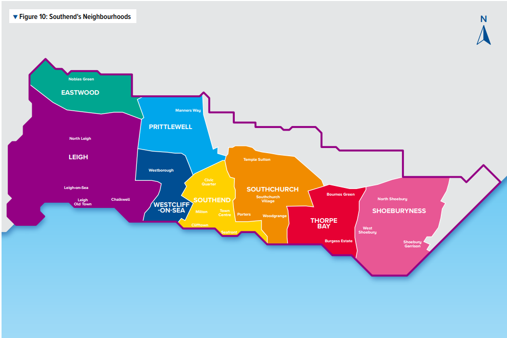
Eastwood
Eastwood is a relatively low rise neighbourhood on the north west edge of the Borough, featuring predominantly post-war residential buildings which vary in style and format, but are generally low density with a number set out in informal cul-de-sacs. Whilst often providing for a quiet suburban character, this can result in a lack of clear routes through the area for pedestrians and cyclists. The A127 Southend arterial road forms a barrier dividing Eastwood from other parts of the Borough, and improvements to key junctions have been completed or are underway to reduce the severance effect of the road.
Important employment sites are located at Aviation Way, Laurence Industrial Estate, Progress Road and Airborne Close/Industrial Estates. It will be important that these employment areas are retained and enhanced.
Rayleigh Road provides for a range of retail, cafes, restaurants and commercial services serving local needs. These have been recently enhanced with the development of a large Lidl foodstore. Further retail provision is provided at Western Approaches anchored by a large Morrison’s foodstore.
Eastwood contains few elements of significant historic value, the exception being the ancient Green Way at its northern edge abutting the Cherry Orchard Jubilee Country Park which provides for informal countryside pursuits. This is supplemented by the more formal green spaces at Eastwood Park and Edwards Hall Park.
Leigh
London Road forms a linear, predominantly commercial spine, dividing north Leigh from the main popular and thriving retail centre of Leigh Broadway and Leigh Road. The shopping centre suffers from a lack of off street car parking facilities.
North of the London Road are the residential areas of Belfairs and Blenheim, with a mix of Edwardian and Inter-War dwellings, and some more modern, larger properties adjacent to Belfairs Wood and Golf Course. This part of the Borough contains a number of secondary schools, playing fields and parks, and has a leafy feel with a large number of mature street trees and grass verges, including within Blenheim Chase and Highlands Boulevard.
The London Road is well served by public transport and is likely to be able to support increased density given its sustainable location. To the south of the London Road the area is characterised by areas of higher density terraced properties, with limited off-street car parking facilities. The exception is the Marine Estate at the western edge of the Borough and Chalkwell area where there are larger detached and semi-detached dwellings set within generous plots.
On the coast the original Old Leigh fishing settlement is now a popular visitor destination with a number of cafes, pubs and restaurants. The area retains traditional fishing and marine activities giving the area its distinctive character. This character continues along the seafront to Chalkwell which contains mainly substantial detached properties set within spacious gardens. Most properties are two to three storeys in height, although there are several substantially taller buildings along the seafront, with pressure for re-development of the Victorian and Edwardian villas on the seafront with additional taller buildings.
Reflecting its historic origins and coastal architecture, Leigh contains a number of Conservation Areas at Chapmanslord on the Marine Estate, Leigh Old Town, Leigh, and Leigh Cliff, the Crowstone and many listed buildings.
These neighbourhoods have an attractive residential environment, however, there is continuing demand for infill development and extensions to existing properties. These can impact on the character of the neighbourhoods and it will be important to retain the areas distinctive character. The development of numerous garden frontages and verges for off-street parking has reduced greenery and the ability of the land to absorb surface water run-off.
Westcliff
Westcliff’s development followed the establishment of the railway. It contains areas of densely developed terraced and semi-detached Victorian and Edwardian housing, with Westborough having a particularly strong grid layout and rhythm of terraced streets. A large number of these properties have been sub-divided, leading to growing demand for on-street parking, and there is generally poor tree cover within these streets, and a lack of local open space, reflecting the high density of development. Further opportunities should be sought for greening the neighbourhood with appropriate soft landscape enhancements. As in the high density areas of Leigh, Westborough has witnessed the development of numerous garden frontages and verges for off-street parking which reduces greenery and the ability of the land to absorb surface water run-off.
London Road has a strong commercial focus within Westcliff, with shops and community facilities including the library and Palace theatre and there are a number of opportunities to increase density along the route given the frequent bus service and sustainable location. The stretch of seafront includes the Cliffs Pavilion regional entertainment centre, Casino, cafés and restaurants. Linking the two is Hamlet Court Road district shopping centre serving local community needs. It has a number of impressive Edwardian and inter-war buildings with a decorative character, albeit these are dispersed throughout a long length of shopping frontage.
Prittlewell
Prittlewell contains some of the oldest buildings in the Borough, which developed as the ‘South end’ of Prittlewell. The historic settlement is focussed around St Marys Church and the Priory, within Priory Park. The area is generally characterised by low and medium density housing, although there has recently been a mixed development of higher density north of Priory Crescent on the site of the old Ecko factory. There are also a number of yards and industrial areas that could be improved and potentially redeveloped. Should Southend United football club re-locate there would also be a significant residential development opportunity close to the town centre on Victoria Avenue. Local shopping needs are provided by neighbourhood parades whilst the out of town Tesco superstore provides for wider local needs.
Southend
Southend contains the main retail heart of the Borough, within the town centre, and is the principal transport hub for the town with two railway stations and the central bus station. Just to the north of the high street, Victoria Avenue is the location of its main civic functions, and a number of tall buildings formerly used as offices which have been converted to residential accommodation. In addition to potential for new residential accommodation within the upper floors of high street properties, there are also several mixed use development opportunity sites within the town, including Queensway, Baxter Avenue, Esplanade House and Seaway and Tylers Avenue car parks. The dual carriageway and roundabout at Queensway forms a major barrier for pedestrians. The Better Queensway project aims to provide high quality new residential properties and public space, and to better integrate the town centre into its residential hinterland to the north and east.
This neighbourhood also contains the Conservation Areas of Milton and Clifftown, to the west of the high street, and the Kursaal, Warrior Square and Eastern Esplanade to the east. There are also heritage assets at the southern end of the high street, including the grade II listed Pier. The central seafront area on either side of the Pier is a focus for tourism and leisure contributing to the 7 million visitors to the borough each year.
Southchurch
Southchurch has a strong grid character, provided by the regular streets of Victorian and Edwardian dwellings to the north and south of Southchurch Road. Properties to the south tend to be grander and more detailed, particularly towards the seafront and Southchurch Park. Southchurch Village local centre, along Southchurch Road, is the commercial hub of the neighbourhood, containing many independent shops. There are a number of opportunities to increase density along Southchurch Road given it is sustainable location. To the north of Southchurch Road dwellings were built during the post war period, and have a more fragmented street pattern, including some residential towers. On the northern periphery of the area is the Waitrose superstore and Fossetts Retail Park. Southend United Football Club have had long standing plans to relocate its facilities to land north of the retail park.
Thorpe Bay
Thorpe Bay developed with the coming of the railway into a relatively low density area, with detached and semi-detached dwellings set within larger plots with wide central boulevards and green verges. Dwellings to the south of the railway line have a strong grid form with wide plots of generous proportions, although there are also streets with modest properties, including bungalows. The Thorpe Bay Broadway provides for local shopping and commercial needs. The main threat to the area is from larger scale developments, particularly along the seafront. Incremental change on a plot by plot basis should be sympathetic to the overall scale and character of the area.
Shoeburyness
Shoeburyness contains a number of distinct residential and industrial areas. The inward facing character of some of the more recent housing developments has meant the urban form within Shoeburyness is more fragmented than other parts of the Borough. The local shopping and commercial needs are served by the centres along West Road and Ness Road and supplemented by the 1980’s built large Asda superstore in North Shoebury. The area contains a number of important employment sites which should be retained and enhanced.
South Shoebury has a more obvious grid form of streets, with relatively large plots. The New Garrison development reflects the nature and historical significance of the original Garrison buildings, with a prominent frontage to the estuary. The Garrison is designated as a Conservation Area. The redevelopment has also enabled continuous public access from East Beach around the coast through the new Gunners Park.
Southend's neighbourhoods - Have your say
Please provide comment in support of your choice
11.1
What do you think are the key issues facing the neighbourhoods in the Borough?
11.2
What do think are the possible options available for resolving these issues?
(Please state the neighbourhood you are describing)