- Policies map
- Interactive Sites Map
- Evidence documents
- FAQs
- Local Plan Videos
- Consultation Events
- Local Plan Preferred Approach PDF
- Local Plan Preferred Approach Summary PDF
- Call for sites
- Sustainability Appraisal
- Sustainability Appraisal Summary
- How to contact us and give us your views
- Adopted plans
- Local Development Scheme
- Statement of Community Involvement
Southend New Local Plan Preferred Approach with Options
Have your say
The Local Plan Preferred Approach with Options consultation is now closed.
Welcome to the Southend Local Plan – Preferred Approach with Options Consultation.
Each local authority is required to prepare a Local Plan for its area. Southend’s Local Plan will set out policies and proposals to guide the city’s development up to the 2040s and beyond.
Scroll to view the Local Plan content below or use the menu on the left to navigate to areas of interest.
Please click the comment buttons to answer the question posed, you’ll need to register to do this. Your feedback will inform the preparation of the final version of the plan that will be published for comment next year.
The consultation closed at 5pm on 30th September 2025.
Further Information
Please visit our Exhibition Room and view our Local Plan Videos which provide a summary.
Draft Policy Designations and potential Site Proposals can be viewed here: Policies Map and Interactive Site Map.
Further information, including consultation events, FAQs, evidence base and sustainability appraisal are available using the menu at the top.
Having an up-to-date Local Plan that is shaped through community engagement, provides an important tool to help manage future development proposals that would otherwise come forward without local policies guiding the type, scale and location of new development.
We first consulted on an 'Issues and Options' document in early 2019. Building on the feedback received we then published a 'Refining the Plan Options' document in 2021 for further public comment. The feedback received on these documents has provided the foundation for preparing the latest version of the local plan, the 'Preferred Approach with Options'. Previous comments can be viewed on the website.
A common theme has emerged for the need to ensure that the infrastructure to support new development and growth is provided, particularly in relation to highways, health and education facilities and access to open space provision. This 'infrastructure-led' theme has been enshrined throughout this version of the Southend New Local Plan. We are committed to prepare an Infrastructure Delivery Plan alongside preparation of the local plan.
Once again, we are now seeking your comments and views on this document which sets out a draft strategy, proposed policies, and identifies specific sites that could contribute to meeting future development needs and poses the question of whether to include the option of a new neighbourhood on land north of Southend (see section 3b.).
Your input will be invaluable in contributing to a final version of the Local Plan to be prepared following this consultation. Please click the comment buttons to answer the question posed below, you’ll be prompted to register to do this. You can also contact us as follows: How to contact us and give your views | Southend Local Plan
How this Document is Structured
Layout and how to use this document
The Local Plan is divided into 13 chapters within 8 overarching sections, with a Glossary and other Appendices at the back.
- Chapter 1, the introduction, sets out the context and purpose of the Southend Local Plan.
- Chapter 2 sets the scene and looks at the city's historical context, demographic factors, the regional context, key issues and drivers for change.
- Chapter 3 describes Southend's overarching long term Spatial Vision, accompanying Strategic Objectives, and the Strategic Policies setting out the key strategy and guiding principles for development in Southend and associated Key Diagram.
- Chapter 3b Poses the question on whether to build a new neighbourhood on land to the north of Southend.
- Chapter 4 to 11 set out the thematic policies to manage development and help deliver the overarching spatial vision and strategic objectives. These sections start with a Strategic Policy and are then followed by a set of more detailed Development Management Policies. A guide to the Strategic Policies and the Development Management Policies and how to use and interpret them is set out below.
- Chapter 12 shows what Strategic Policies and Development Management Policies will mean for the Neighbourhoods of Southend, setting out what changes are expected to take place up to 2040. This section also sets out specific Neighbourhood Policies and Proposals (sites that the Southend Local Plan allocates for future development). Review of the Southend Central Area Action Plan (SCAAP - adopted 2018) will primarily fall within this section (i.e. Southend Central neighbourhood).
- Chapter 13 explains how the policies proposed will be delivered. This is closely linked to the Infrastructure Delivery Plan, which will set out detailed infrastructure requirements to support the Strategic Policies and how this will be delivered. This section also links to the Monitoring Framework to measure the effectiveness of the policies contained within this document.
- Appendices – further information is provided in the appendices at the end of the document
- Policies Map – proposed designations and proposals (allocations) related to relevant Local Plan policies are depicted on a draft Policies Map for the entire city. Neighbourhood specific maps are also available within Chapter 12.
1. Introduction
1.1 Southend is a vibrant city by the sea. It is a major tourist destination and business centre with a growing population. It is a city of enterprise, culture and opportunity.
1.2 The city lies at the eastern most extremity of the south Essex peninsula at the mouth of the Thames Estuary some forty miles east of London. It stretches along a foreshore of around seven miles, which provides an east/ west linear layout.
1.3 With limited land resources and one of the most densely developed urban areas in the country outside London, harnessing the city's potential for growth and meeting the needs of its resident and business community while addressing the impacts of climate change and technological advances, and having regard to the natural and historic environment, is a major challenge and requires careful planning.
1.4 The Local Plan seeks to meet this challenge by planning for the future sustainable development of the city to 2040, whilst seeking to provide for new homes and jobs and safeguarding the city's valuable parks and green spaces, distinctive heritage and character, and its sensitive coastal environment.
Inclusive Plan Preparation
1.5 An 'Issues and Options' document was published for public comment in February 2019, which represented the first stage in seeking views on what the direction and content of a new Local Plan for Southend should be.
1.6 In the light of comments made, a 'Refining the Options' document was prepared for further comment in August 2021. Representations received have been instrumental in shaping the format of this next stage of Local Plan preparation, namely the 'Preferred Approach with options'.
1.7 The 'Preferred Approach with options' sets out a draft spatial vision and policies and proposals to address the needs of the city. This is set out under specific themes as follows:
- A CITY BY THE SEA – setting out objectives, spatial strategy and principles; managing the impacts of growth and infrastructure and whether to provide a new neighbourhood on land north of Southend.
- A CITY THAT IS HEALTHY AND SAFE - enabling healthy lifestyles and wellbeing;
- A CITY OF OPPORTUNITY - the provision and type of new homes and securing a thriving economy;
- A CITY TO BE PROUD OF - urban design, character and heritage;
- A CITY THAT IS GREEN AND SUSTAINABLE - the natural environment, biodiversity and climate change;
- A CITY THAT IS CONNECTED AND SMART – transport and connectivity;
- THE NEIGHBOURHOODS OF SOUTHEND – proposals for the neighbourhoods of Southend;
- A CITY THAT DELIVERS – how the Local Plan will be delivered and monitored.
1.8 Further comment is now sought on this 'Preferred Approach with options' version of the Local Plan. Following this stage and consideration of the feedback the Local Plan will be further refined to produce a 'Submission' document which will be published for comment and then be examined in public before an Independent Inspector.
1.9 The preparation timetable for the Local Plan is set out below (Figure 1.1) and detailed in the Southend Local Development Scheme (LDS).
Figure 1.1: Preparation Timetable
|
1. Issues and Options Consultation Complete |
Evidence preparation on-going |
|
2. Refining the Plan Options Consultation Complete |
|
|
This Stage 3. Preferred Approach with options Consultation (Q2/ Q3 2025) |
|
|
4. Publication of final Local Plan Consultation on Soundness (Q2/ Q3 2026) |
|
|
5. Submission 2026 Submission to adoption usually ranges from 6 to 12 months, subject to independent examination process |
(Q refers to the quarter of that calendar year)
1.10 The various stages of Local Plan preparation have drawn upon an extensive evidence base which is regularly updated. Documents comprising the evidence base are referenced throughout this document. The Local Plan 'Preferred Approach with Options' is also accompanied by an Integrated Assessment, comprising Sustainability Appraisal setting out the impact of the draft strategy and planning policies from an environmental, social and economic perspective, and an Infrastructure Delivery Plan detailing infrastructure needs.
1.11 Once adopted the Southend New Local Plan will replace several current adopted planning policy documents, namely:
- the Southend Core Strategy (2007);
- Development Management Document (DPD 2015);
- Southend Central Area Action Plan (SCAAP 2018); and
- some of the strategic policies within the London Southend Airport and Environs Joint Area Action Plan (JAAP 2014);
1.12 These policy documents are supported by three Supplementary Planning Documents (SPD) namely:
- Design and Townscape Guide (SPD1 2009);
- Planning Obligations A Guide to s106 and Developer Contributions (SPD 2 2015); and
- Streetscape Manual (SPD 3 2015).
These will be updated and reviewed as appropriate.
1.13 The Essex and Southend Waste Local Plan (2017), prepared jointly by Southend and Essex County Council, sets out an approach to 2032 and will be reviewed in due course separately.
1.14 The current adopted planning policies to be replaced by the New Local Plan upon adoption are detailed in Appendix 3.
Southend in the wider sub-region
1.15 Set at the eastern end of a peninsula, Southend looks westwards towards London and relies on transportation links across south Essex for its accessibility.
1.16 Southend is a Unitary Authority responsible for all local government services, unlike many other '2-tier' local authorities that rely on County Council's to delivery certain services, including transport, education and waste. Nevertheless, the Southend new Local Plan has been prepared in close collaboration with neighbouring authorities, including the South Essex Councils and other key stakeholders to ensure it has regard to its strategic context.
1.17 The hierarchy of strategies and plans related to Southend are set out below in Figure 1.2. The future development of Southend needs to be viewed in the context of growth and development within the South Essex sub region (Figure 1.3). The councils of Basildon, Brentwood, Castle Point, Rochford, Southend-on-Sea, Thurrock and Essex County have formed South Essex Councilswww.southessex.org.uk (SEC). They are working together to promote prosperity and wellbeing in the region and make it the place to live, visit and do business.
Figure 1.2: Hierarchy of Strategies and Plans Related to Southend
Figure 1.3: Southend Context within South Essex
2. About Southend
Historical Context
2.1 Southend takes its name from being a small fishing village located at the 'south end' of Prittlewell which has 6/7th century origins as a Saxon village. The finding of a Saxon King burial chamber nearby in 2003 illustrates the historical and archaeological importance of the area. Leigh to the west also has its origins as a Saxon fishing village and grew to become a prosperous port in the sixteenth century.
2.2 It was not until the late 18th century when sea bathing became fashionable and popular that some limited growth occurred along the foreshore at Southend with the Regency developments of Royal Hotel and Royal Terrace. In 1830 a wooden pier was constructed to receive sea passengers visiting the area which was later extended to reach deep-water. In 1891 the pier was reconstructed in iron and two years later its own railway was opened. The Pier remains the longest leisure pier in the world and the iconic face of Southend at the heart of its resort facilities.
2.3 The opening of the railway line from London Fenchurch Street to Southend Central in the 1850's, followed by the line from London Liverpool Street to Southend Victoria in 1889, was the catalyst for rapid growth and saw Southend's population increase significantly from under 10,000 in 1890 to 150,000 in the mid 1940's.
2.4 The arrival of the railway in central Southend stimulated residential development including the laying out of Clifftown, and its distinctive Victorian large yellow stock brick buildings with Welsh slate roofs, together with Prittlewell Gardens, the first public park to be created in the city. To serve the increasing population, Southend's retail centre developed between the two central railway stations and the Pier.
2.5 The mid to late Victorian period saw continued growth particularly to the north of Central station and to the east of Leigh on Sea. Larger villas were built often individualistic with corner turrets, employing a wide range of building materials together with larger areas of terraced housing based on regular grids.
2.6 In the east of the city the British School of Gunnery was opened in 1848 in Shoeburyness with associated barracks and the railway line extended from central Southend to serve the area some thirty years later. This stimulated residential and commercial development in the adjoining area. The Shoebury Garrison remained in military use until 1976 when it was disbanded. The site was eventually sold in 2000 for development when it was converted into predominantly residential use and now forms the historic Garrison conservation area with the adjacent Gunners Park and part of the historic High Street in Shoebury. The military establishments at New Ranges in north Shoebury and adjoining Foulness remain.
2.7 The coming of the railway also saw the growth in popularity of Southend as a traditional seaside resort and the development of hotels and tourist facilities, most notably the commanding Palace Hotel overlooking the Pier and the nearby Kursaal theme park, one of the world's first purpose-built amusement parks. The popularity of water recreation also saw the emergence of the first yacht clubs in Southend which remain a prominent feature on the foreshore.
2.8 At the turn of the century the Edwardian period was one of the most prolific in terms of Southend's growth with the expansion of Leigh-on-Sea up to the London Road and in Westcliff, Westborough and the southern part of Prittlewell. The initial development of areas of Southchurch, both to the north of the railway line and along the seafront also took place. Areas of planned street network, either on a regular grid or flexible grid, were built out by a wide range of developers.
2.9 This expansion of the urban area promoted the establishment of shopping centres at Leigh, Westcliff and Southchurch to serve the needs of the growing population. Hamlet Court Road shopping area in Westcliff became a fashionable retail area and is thought to have been known as the 'Bond Street' of Southend.
2.10 The national recognition of the benefits to health of providing parks in urban areas saw the establishment of such facilities in Southend in the early to mid-1900's to serve the needs of a growing local population. The first parks came into being through a combination of philanthropy and acquisition, namely Priory Park, Southchurch Park, Chalkwell Park, Southchurch Hall Gardens, Belfairs Park and Nature Reserve, Shoebury Park and Eastwood Park. These remain the principal parks in the city and provide valuable green lungs and recreational space within the urban area.
2.11 In the inter-war period there was a significant push to build new areas of housing, and the public housing programme grew significantly. Development took place in Leigh and Southchurch together with the early phases of Thorpe Bay. The classic house of this period was the semi-detached with wider and squatter proportions than its Edwardian and Victorian predecessors. Thorpe Bay was laid out in a grid drawn to generous proportions with wide plots and very large Edwardian and interwar houses as well as a substantial phase of post war bungalows and houses.
2.12 In 1935 Southend Airport to the north of the town was officially opened as a municipal airport having first been used as an airfield by the Royal Flying Corps during World War I before reverting to farmland. The Airport grew to be London's third-busiest airport from the 1960s until the end of the 1970s after which it declined in use until its more recent redevelopment which saw a resurgence in its use and popularity.
2.13 As with the period following the First World War the decade after the Second World War lent renewed vigour and urgency to house building. Initially, for speed a number of pre-fabricated building systems were developed to enable homes to be erected on site as quickly as possible. Examples of these are still evident in Southend. However, conventional brick-built houses very quickly became the norm again, accounting for large areas of new development which owe much to the earlier garden city style housing for their design and planning influences.
2.14 The key infrastructure addition during this period was the development of the A127 as a dual carriageway, providing a new focus for development and particularly industrial and business development, in the northern part of the city. The increase in car ownership and relative ease of access across the north of the Borough promoted suburban housing developments at Eastwood and Shoeburyness.
2.15 The post war period was a boom period in terms of tourism with large numbers of people visiting Southend, some two and a half million people used the Pier in 1950. Although numbers declined in the 1960's with the introduction of cheaper holiday destinations abroad, Southend has retained its status as a major resort destination witnessed by the expansion of Adventure Island theme park adjacent the Pier in the 1990's and by numerous recent hotel and leisure developments.
2.16 The 1960's saw significant redevelopment in the town centre to accommodate the car and provide for new shopping and employment facilities. Victoria Avenue was developed as a gateway to the town centre with large office blocks, civic area and educational establishments, and the Victoria Shopping Centre and multi storey car parks developed. The High Street was one of the first to be pedestrianised in the country. Tall buildings set within areas of landscape were built as part of public housing projects. The Royals indoor shopping centre was developed at the southern end of the High Street in the late 1980's.
2.17 In the face of large redevelopment schemes across the country, in 1967 the Government of the day introduced Conservation Areas to protect areas of special architectural or historic interest. The ability to protect individual historic or architecturally important buildings by 'listing' them, had been introduced after the Second World War. Southend now has 16 conservation areas and numerous listed buildings spread across the city.
2.18 Increased emphasis from central government on allowing out of town shopping areas through the 1980's and 90's resulted in new large supermarket outlets and retail areas being established mainly to the north and east of Southend.
2.19 All these developments gave the city its current urban form. To safeguard the surrounding areas of open countryside from urban sprawl and coalescence with neighbouring settlements, the majority of the open countryside was designated in the late 1980's as forming part of the wider Metropolitan Green Belt stretching from east London across south Essex.
2.20 More recent development has seen a return to more clearly defined urban forms which relate to conventional street patterns, often using modern materials. There has also once again been a focus on town and city centres, with higher density development and sustainable models of living.
2.21 Figure 2.1 provides an overview of Southend's urban/ popultion growth.
Figure 2.1: Urban Growth of Southend
Southend Today - context and issues
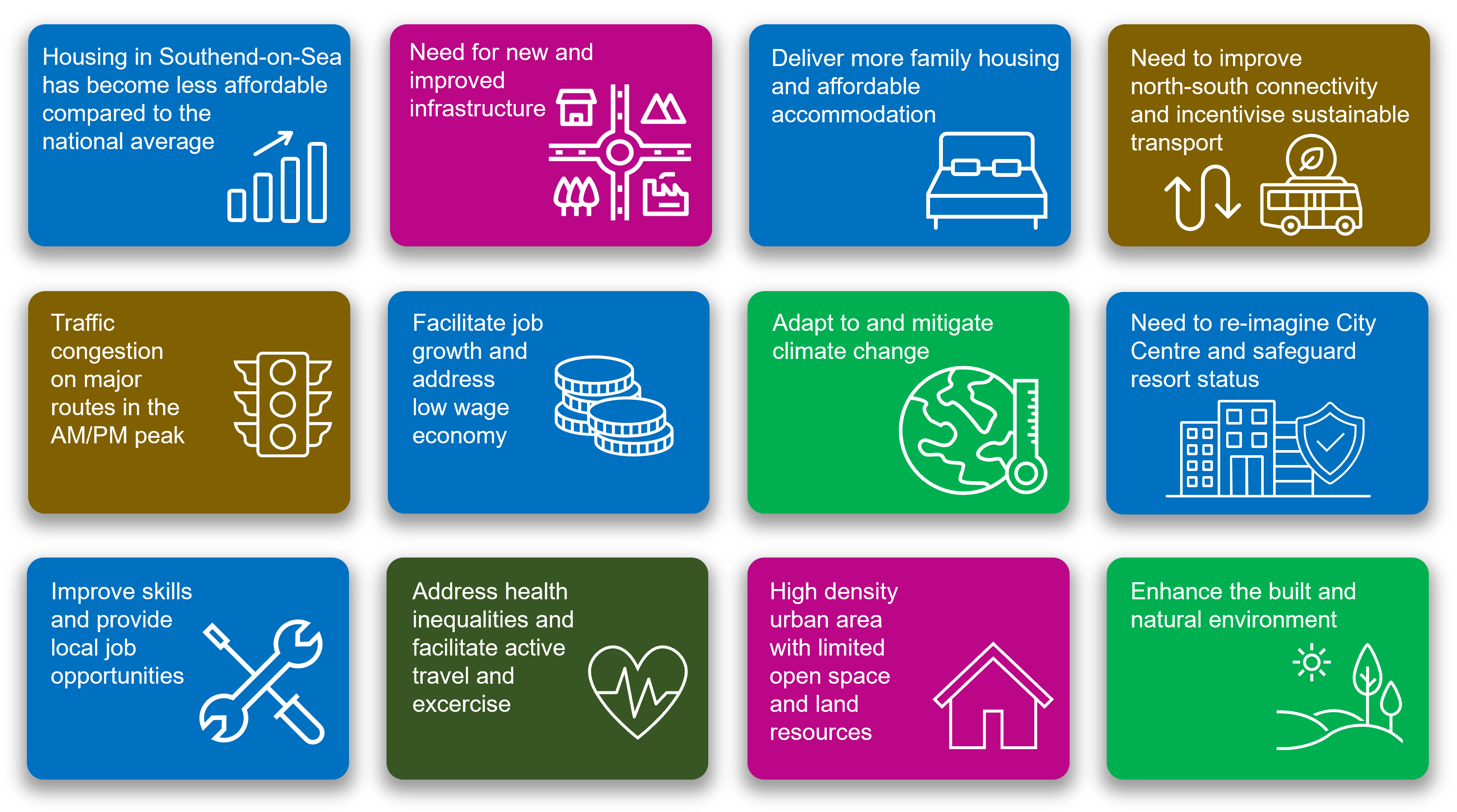
- About Southend – Southend's administrative boundary tightly abuts the existing urban area, and the surrounding open countryside is designated as forming part of the wider Metropolitan Green Belt stretching from east London across South Essex. These factors mean that land resources in the city are extremely limited and provides for a significant planning challenge in seeking to meet future development needs, particularly for housing, whist safeguarding the character and natural amenities of the area. Being located on a peninsula, the geography of the area dictates the surface transportation links to the city which are concentrated in a narrow east-west corridor which present congestion and accessibility issues affecting the local economy and tourism industry.
A CITY BY THE SEA
- Strategy and Objectives – sustainable growth that contributes to future needs whilst protecting and safeguarding the character and natural amenities of the city requires the development of a comprehensive strategy and objectives which underpin the principles and policies of the Plan.
- Securing and Improving Infrastructure – it will be essential that the social and physical infrastructure is secured to meet the needs of a growing population. Education, health, sewage and drainage, and highway infrastructure is already struggling to cope with demand. Further developments need to be carefully planned to ensure that the necessary infrastructure is in place to meet the increasing cumulative demands. This document therefore seeks to adopt an 'infrastructure led' approach.
- The option of providing a new neighbourhood on land north of Southend - due to this significant under-provision in new homes, the Local Plan must consider the possible designation of land designated as Green Belt for residential mixed-use development in line with national planning policy.
A CITY THAT IS HEALTHY AND SAFE
- Enabling Healthy Lifestyles & Wellbeing – There are health inequalities across Southend often exceeding the national average. It will be essential that new development embraces the principle of facilitating healthy lifestyles through promoting walking and cycling and the provision of sport, recreation and green space facilities. The concept of facilitating complete neighbourhoods across the city, where everyday essentials and services are within a convenient walking distance, will help promote healthy lifestyles.
A CITY OF OPPORTUNITY
- Homes - the city has grown into a substantial residential area comprising 83,500 dwellings, providing homes for 182,000 people. This has resulted in the city having one of the highest residential densities in the UK outside London. The Government Standard Method for calculating housing need indicates that 1,405 new homes are needed each year in Southend. Recent housing provision has been concentrated on brownfield sites mainly in the central urban areas with a large proportion of flatted developments. In the City Centre conversion from obsolete office blocks to residential have provided a significant stock of accommodation. However, this provision has not kept pace with demand particularly for affordable and family housing.
- Securing a Thriving Local Economy – the local economy is dominated by small to medium enterprises with 86% of companies employing 10 staff or fewer. There are approximately 80,000 jobs in Southend provided in a variety of commercial areas and designated business estates. There is a need to provide around 450 additional jobs per annum with opportunities for growth in several sectors, including construction, aviation, health industries, tourism and leisure, and business and financial services. It will be essential that the Plan embraces this potential and satisfactorily accommodates the trend for increased working from home and the need for digital infrastructure. The City Centre, London Southend Airport and associated business park, and a cluster of existing employments areas located along the A127/A1159 corridor are well placed to achieve economic growth. It will also be important that education and further education is facilitated capitalising on the city's university campus and apprenticeships and building the skills base.
- Tourism – Southend is a major UK resort and attracts around 7 million day visitors and over 200,000 staying visitors each year which enrich the local economy. There is significant potential to maximise Southend's potential as a visitor destination and resort, particularly in terms of the evening economy and through encouraging overnight and longer stays by capitalising on the resort's success as a day visitor destination. Managing these visitor numbers in a sustainable way will need to be addressed by the Plan, having regard to access and visitor parking.
A CITY TO BE PROUD OF
- Urban Design, Character and Heritage – with limited land resources, areas of high urban building densities and an established local character, quality design and layout will be an important ingredient in new development schemes in seeking to protect the unique character of areas and their sense of place to provide attractive environments where heritage is celebrated and recognised for the role it can play in place making and regeneration.
A CITY THAT IS GREEN AND SUSTAINABLE
- Enhancing our Natural Environment – with seven miles of foreshore and over 500 hectares of green space, the city has a rich and varied landscape providing for recreation and important wildlife habitats and green lungs within the densely developed urban area. It will be essential that the foreshore and green spaces are protected, and biodiversity is enhanced within an improved network of green corridors.
- Climate Change and Environmental Protection – all development and future proposals will need to address the challenges of climate change and flood risk, including energy efficiency. Southend is susceptible to local water surface flooding under conditions of extreme rainfall and from tidal flooding in certain locations. It is essential that these issues are properly managed and planned and that sustainable drainage systems are incorporated into development schemes.
A CITY THAT IS CONNECTED AND SMART
- Transport and Connectivity – the city is served by two railway lines and two highway arteries (the A127 and A13) within a confined east - west corridor to London. Reliability and congestion issues can have major impacts on the local economy and its tourism offer. It will also be important for the Plan to embrace sustainable transport provision, including the bus, cycling and walking particularly for short journeys, whilst recognising the important role that the private car has to play in the local economy, particularly for tourism.
- London Southend Airport – Following the impacts of Covid-19 the Airport is in a state of recovery and it is likely to take several years to return to pre-pandemic levels. Any further growth will need to be carefully managed in association with all relevant partners to ensure that growth takes into full account environmental considerations, particularly those relating to noise and surface access. The Airport Business Park continues to provide a significant opportunity for new employment floorspace and jobs.
THE NEIGHBOURHOODS OF SOUTHEND
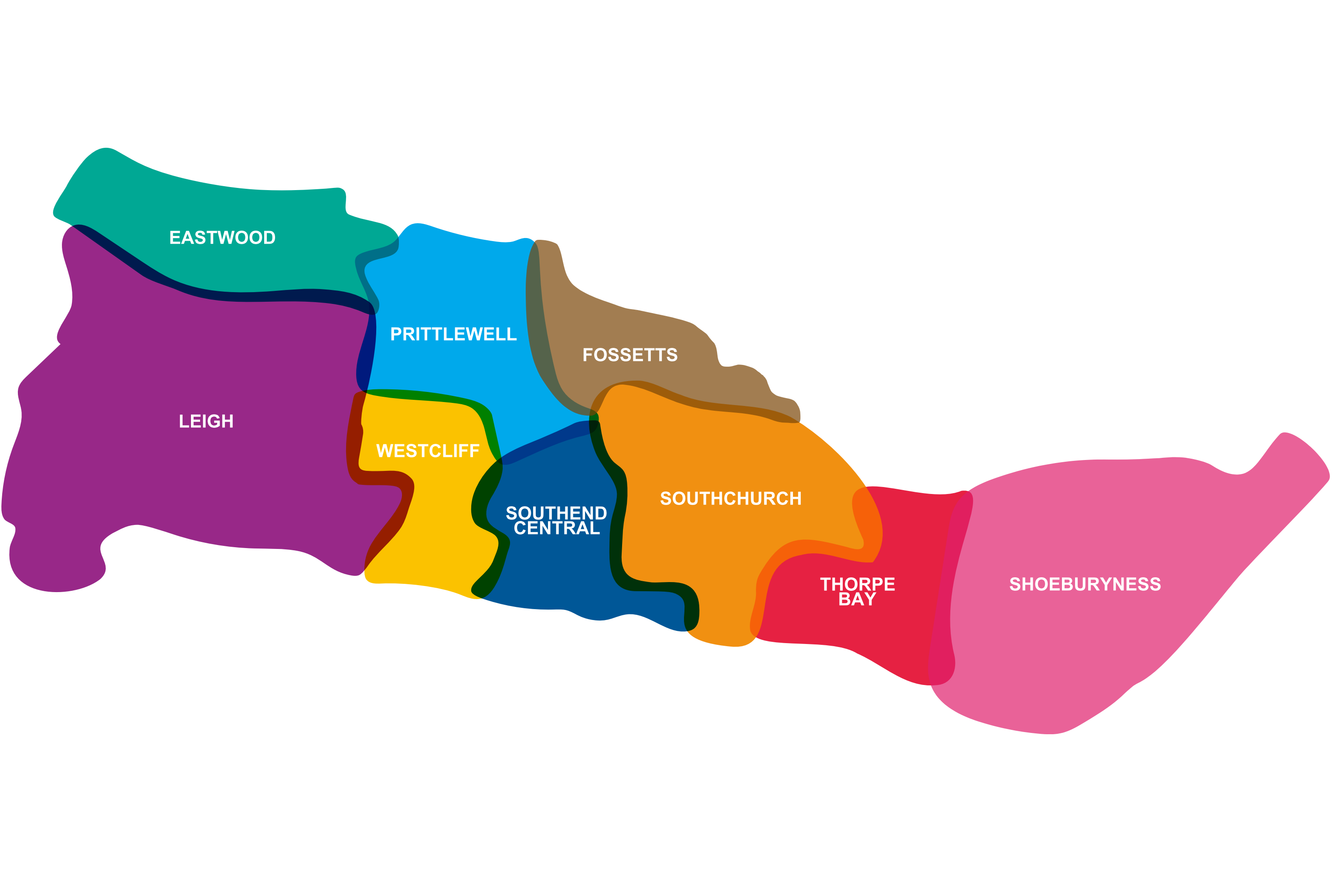
- Place Specific Policies – Southend has grown organically from the villages of Leigh, Prittlewell and Shoeburyness to form a cohesive urban area comprising distinct neighbourhoods (see Figure 2.2). It will be important that this local distinctiveness and character is recognised and respected in future development schemes. It will also be important for the Plan to address the changing role of the retail and commercial centres within the neighbourhoods, particularly in the City Centre. The City Centre has been greatly impacted by the changing shopping patterns of customers with the advent of on-line shopping and the demise of a number of prominent national retail outlets.
Figure 2.2: The Places of Southend
(Southend Neighbourhoods)
3. Strategy, Objectives and Infrastructure
A CITY BY THE SEA
3a. This chapter sets out the draft Vision of the Local Plan describing how Southend will grow in response to the local challenges and opportunities.
The Vision is translated into a set of draft Strategic Objectives which in turn have informed the draft strategic policies, which provide the overarching framework for other thematic strategic policies and more detailed policies in other sections of the Local Plan.
Where we are now
Past Visions
3.1 The Local Plan Preferred Approach seeks to build on previous visions, including that of the Southend Core Strategy, London Southend Joint Airport Area Action Plan and the more recent Southend Central Area Action Plan. It also seeks to embrace The Southend City Vision: Our City, Our Future.
3.2 The Southend City Vision ('Our City, Our Future'), developed by the Southend City Partnership, sets a clear direction for Southend's growth and development, prepared through extensive consultation and engagement. The consultation highlighted priorities and aspirations from residents, business owners, visitors, and students. The communication campaign and engagement strategy reached over 10,000 people, with over 2,000 responses received to the consultation survey.
3.3 Looking to 2035, the vision is that: 'Southend-on-Sea is a vibrant, welcoming and well-connected coastal city brimming with opportunities, seamlessly blending its rich heritage with a contemporary, creative outlook.' It prioritises the following themes: safe and thriving communities; bustling high streets and business spaces; haven for leisure and creativity; clean, green and proud. For more information see: Southend City Vision - Visit Southendwww.visitsouthend.co.uk/southend-city-vision.
3.4 A key and integral part of developing the Local Plan will be to encapsulate The Southend City Vision and present a place-based vision and set of strategic objectives for the Local Plan

Refining the Plan Options - What You Said
3.5 The previous local plan consultation 'Refining the Plan Options' document, which represented the second stage of public consultation on the new Local Plan, set out a draft aim, development principles and a set of strategic objectives for comment. You told us that in relation to these elements of the draft plan:
- the Draft Aim, Spatial Objectives and Development Principles are broadly supported;
- infrastructure of all types is essential to support new development;
- climate change should be central to the plan and given urgent attention to reach net zero ambition;
- housing numbers are unrealistic in the context of Southend;
- transport accessibility must be improved, including for non-car modes;
- the regeneration of the high street and local centres is needed to support local businesses and jobs;
- our neighbourhoods should be sustainable and respect the different character areas of Southend; and
- the environmental aims should include more detail on protecting the coastline, biodiversity, agricultural land, and flood risk management.
3.6 A draft vision and strategic objectives have been amended in response to these comments. The thematic sections of the plan then set out the detailed strategy for these and the relevant policies relating to them.
Where we want to be
The Vision
3.7 The draft long-term vision and strategic objectives encapsulates what we envisage the city will be like in the future. The planning policies contained within the Local Plan will seek to aspire to deliver the vision.
Southend Long Term Vision
Southend-on-Sea is prosperous and well connected, with a quality of life to match. As a "City by the Sea", we have led the way on how to grow a sustainable, healthy and inclusive city that has made Southend more resilient to a changing climate.
Together, the distinct neighbourhoods of Southend-on-Sea provide a diverse range of opportunities for people at all stages of their life, whilst improved infrastructure, facilities, green spaces and services are of high quality, easily accessible and support personal independence and a strong sense of community.
We cherish our coastal identity, culture and celebrate our built heritage – a seafront that entertains and a shoreline, from the historic Shoebury Garrison to the fishing village of Old Leigh, which always inspires.
Strategic Objectives
A City that is Healthy and Safe
Strategic Objective 1: Deliver new and improved infrastructure to meet sustainable growth by pursuing an 'infrastructure led' approach.
Strategic Objective 2: Contribute towards the delivery of sustainable, safe and healthy complete neighbourhoods.
Strategic Objective 3: Reduce deprivation and reduce inequalities between the neighbourhoods of Southend.
Strategic Objective 4: Promote and protect community and sport and recreation facilities.
A City of Opportunity
Strategic Objective 5: Develop Southend's role as a major business centre attracting investment and providing new jobs, where both existing and new enterprises can prosper.
Strategic Objective 6: Regenerate the City Centre to provide for a diversity of uses, including cultural and creative enterprises, complemented by a growing residential population, set within a quality and green environment.
Strategic Objective 7: Establish Southend as a major resort and year-round destination and increase the value of the visitor economy.
Strategic Objective 8: Secure the regeneration of Southend as a cultural and intellectual hub and a centre of education excellence.
Strategic Objective 9: Provide a choice of homes for people at all stages of life.
A City to be Proud Of
Strategic Objective 10: Southend is the regions first choice coastal tourism destination, and the seafront and marine environment has been protected and enhanced.
Strategic Objective 11: Enhance the city's built heritage and capitalise on it to promote tourism and regeneration.
Strategic Objective 12: Maintain and enhance the distinct character and environment of the city's neighbourhoods to ensure that they remain vibrant, attractive and accessible.
Strategic Objective 13: Create well designed and attractive places that respond positively to the distinctive character and historic value of the city's different neighbourhoods and enhances the natural environment.
Strategic Objective 14: Make the most efficient and effective use of land and buildings and prioritise the use of previously developed land.
A City that is Green and Sustainable
Strategic Objective 15: Prevent or minimise the impact of climate change, including for air quality and flood risk and improve energy efficiency.
Strategic Objective 16: Improve the quality and accessibility of green space whilst safeguarding environmental assets and enhancing biodiversity.
Strategic Objective 17: Greening the city through extensive landscaping and tree planting to create a network of green spaces and corridors.
Strategic Objective 18: Protecting and enhancing the quality of the coastal environment and its marine biodiversity.
Strategic Objective 19: Regenerate and bring back into productive long-term use land that is contaminated or otherwise degraded, including where appropriate use for biodiversity or other natural resource value.
A City that is Connected and Smart
Strategic Objective 20: Improve accessibility, connectivity, sustainability, safety and ease of movement to, from and within the city.
Strategic Objective 21: Reduce the need to travel by achieving closer alignment of homes, jobs, infrastructure and services within a network of highly accessible neighbourhoods.
Strategic Objective 22: Provide multi-modal transport facilities that achieve seamless and integrated connectivity between neighbourhoods, with neighbouring towns and the wider region.
Strategic Objective 23: Facilitate the sustainable growth of London Southend Airport to realise its potential in becoming a carbon neutral regional transport hub that provides a range of job opportunities.
Strategic Objective 24: Explore opportunities to utilise the River Thames as a sustainable transport corridor for business and leisure use subject to protecting the coastal and marine environment.
Have your say…
Please explain your answers
QSO1: Do you agree with the draft Vision and Strategic Objectives that set out where we want to be in the future? Please explain your answer.
Did you know - Figure 3.1: Southend City at a Glance
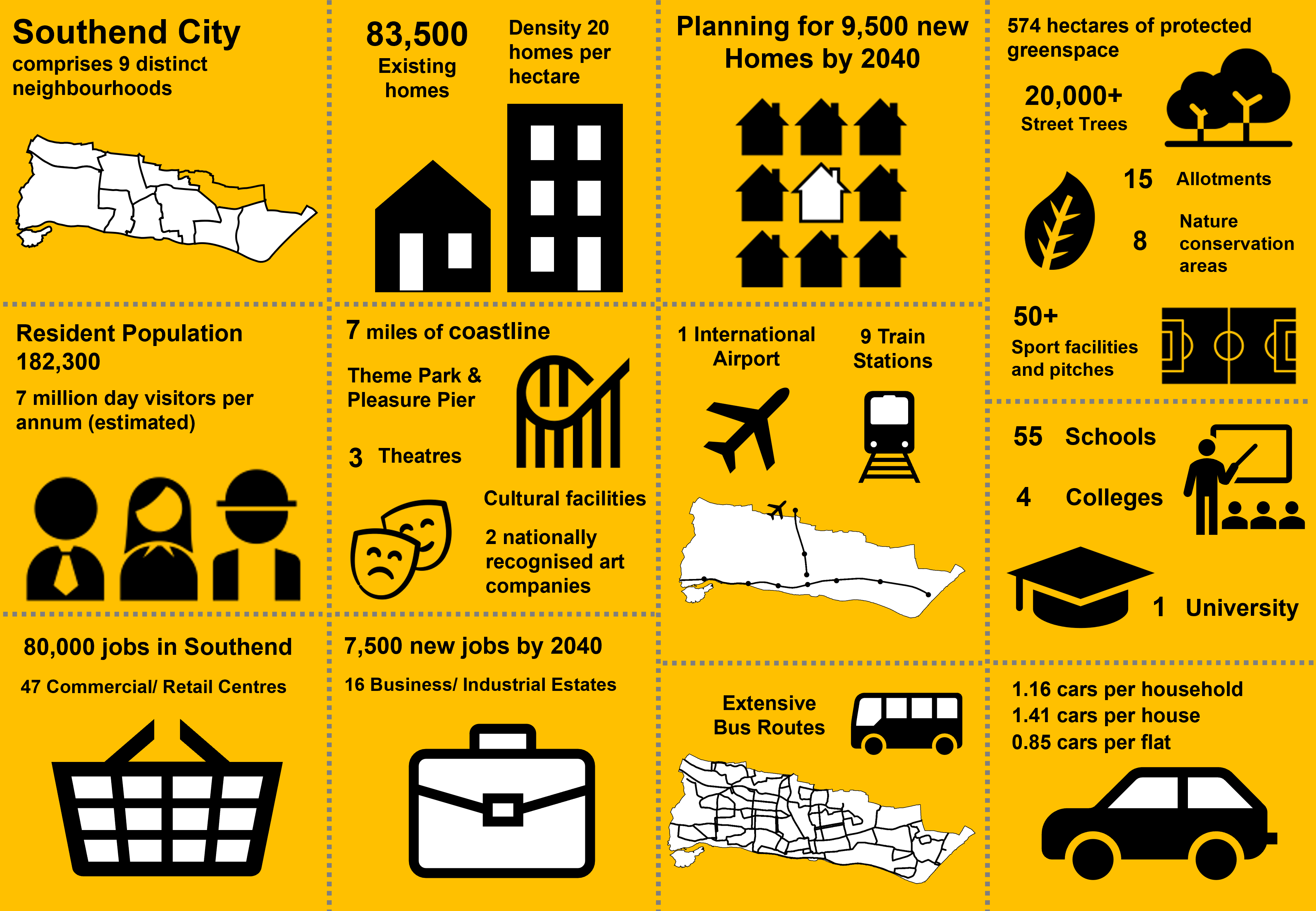
Figure 3.2: Strengths and Opportunities
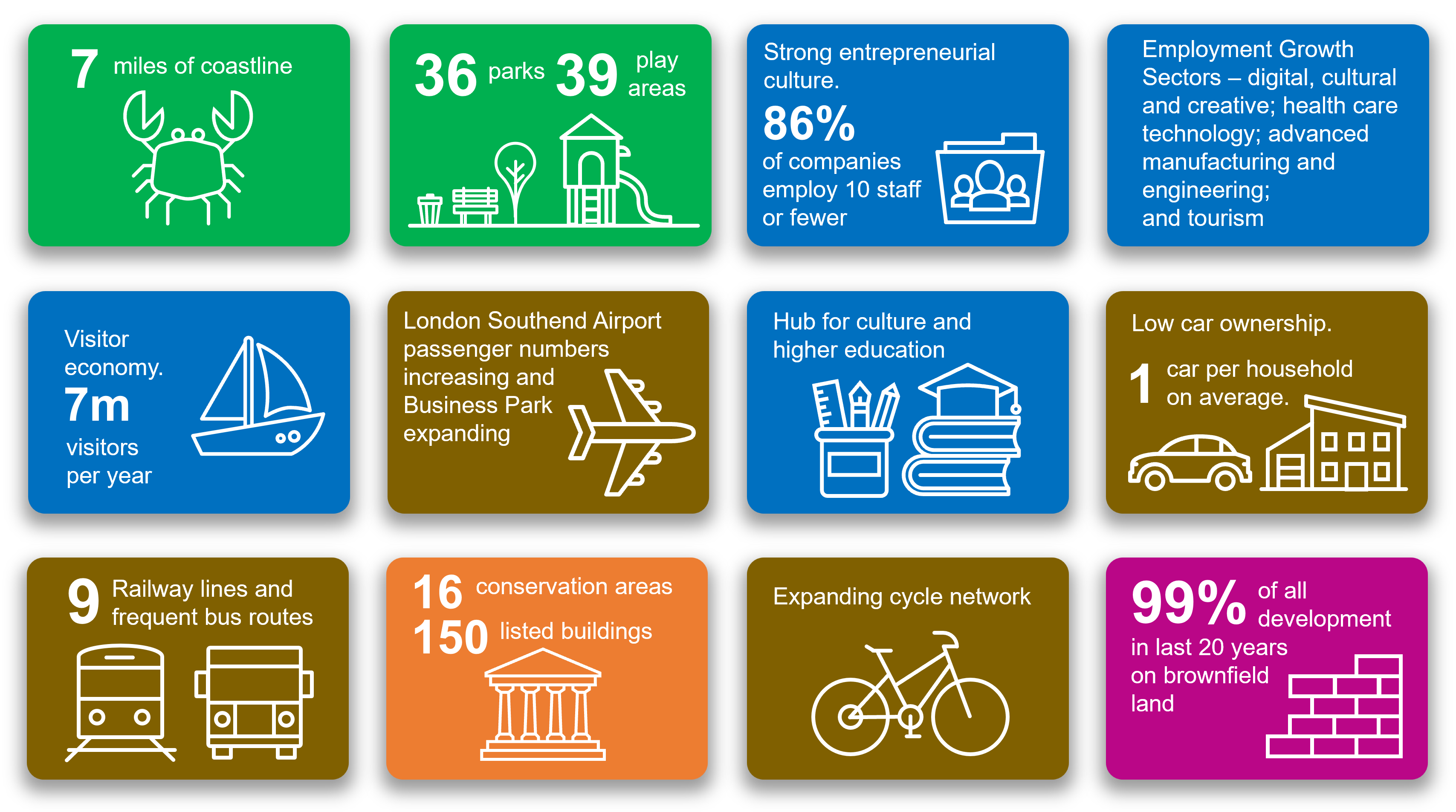
Figure 3.3: Challenges
How we are going to get there
Overarching Strategic Policies
3.8 The Vision and Strategic Objectives have in this version of the draft plan been developed into three Strategic Policies, namely:
- Strategic Policy SP1: Spatial Principles;
- Strategic Policy SP2: Spatial Strategy; and
- Strategic Policy SP3: Infrastructure
3.9 The three strategic policies provide the framework for other thematic strategic policies and more detailed development management policies which are set out in subsequent sections of this Local Plan Preferred Approach.
Draft Strategic Policy SP1: Spatial Principles
3.10 The Spatial Principles seek to ensure that all development proposals achieve quality design and environments that make the best use of previously developed land to deliver sustainable development that enhances the built form and sense of place in the city whilst protecting its character and amenities.
3.11 Strategic Policy SP1: Spatial Principles embraces comments made on the development principles as contained in the ‘Refining the Plan Options’ document.
Strategic Policy SP1: Spatial Principles
- The Council will require all new development to accord with the following Spatial Principles where relevant:
- Ensure development is served by necessary infrastructure by pursuing an 'infrastructure led' approach;
- Achieve the urban renewal and sustainable regeneration of Southend's existing urban area and make the best use of suitable previously developed land for development;
- Regenerate and renew Southend City Centre;
- Minimise the use of 'greenfield' land;
- Promote and enhance tourism, culture and leisure;
- Promote Southend's sub-regional role as a place for economic growth particularly at the key business clusters of Southend City Centre, London Southend Airport and the employment areas as defined on the Policies Map;
- Enhance the city's role as a cultural and intellectual hub and promote Southend as an educational centre of excellence;
- Locate development at well-connected and sustainable locations and facilitate and promote modal shift through improved sustainable and active travel;
- Support good quality, innovative design that contributes positively to the creation of successful places;
- Safeguard and promote the vitality and viability of existing City, District, Neighbourhood and Local Centres;
- Make Southend more resilient to the effects of climate change through mitigation and adaptation, including flood risk management and vulnerability to increased temperatures;
- Respect the character and appearance of landscapes and the built environment, and conserve and enhance the historic environment;
- Create, enhance and protect a comprehensive green and blue infrastructure network across the city and ensure net gains in biodiversity;
- Avoid areas of land instability or adequately mitigate harmful effects.
Draft Strategic Policy SP2: Spatial Strategy
3.12 The Spatial Principles set out above in Strategic Policy SP1 are applied in Strategic Policy SP2: Spatial Strategy to provide a clear indication of how regeneration and growth will be distributed within the city to deliver sustainable regeneration and to ensure that growth is directed to places with good concentrations of infrastructure and accessibility to a variety of transport modes.
Strategic Policy SP2: Spatial Strategy
Sustainable Development
- Growth in homes, jobs and services that constitutes sustainable development will be welcomed where it contributes to the achievement of, and does not compromise, the Council's Strategic Objectives.
- Development and investment will be expected to contribute to the effectiveness and integration of the strategic transport network.
- All development will need to accord with the Policies Map.
Regeneration and Growth
The primary focus of regeneration and growth within Southend will be:
- The Local Plan makes provision for 9,500 new homes and 7,500 additional jobs to 2040 within the existing built-up area of Southend and on land at Fossetts Farm to the north of the city.
The primary focus of regeneration and growth within Southend will be:
- Southend Central Area - regenerate the City Centre as a sub-regional centre and the Central Seafront as the focus for major resort facilities, providing a full range of quality services to provide for new jobs and 4,000 additional homes in conjunction with the upgrading of strategic and local passenger transport accessibility, including the development of Southend Central and Southend Victoria railway stations as strategic transport interchanges, together with the enhancement of the University Campus.
- In addition, appropriate regeneration and growth will be focussed in the following locations:
- Seafront - to enhance the Seafront's role as a successful leisure and tourist attraction and place to live, and make the best use of the River Thames, subject to the safeguarding of the biodiversity importance of the foreshore*.
- Fossetts - To create a sustainable community by enhancing the economic offer around Temple Farm, leisure potential of Garon Park and introducing high quality mixed-use residential development at Fossetts Farm, delivering around 1,200 new homes, with improved connections and access to existing shops and services.
- Shoeburyness - to promote the role of Shoeburyness as a place to live and work, led by the successful redevelopment at Shoebury Garrison, regeneration of local shopping centres and existing industrial estates to secure new jobs and 700 additional homes, linked to improved access.
- London Southend Airport and environs – providing a strategic employment opportunityto support the delivery of additional jobs including employment directly related to the Airport. These jobs will contribute to the delivery of the jobs totals for Rochford District Council and Southend-on-Sea City Council as per the provisions in the adopted airport Joint Area Action Plan – the apportionment to each authority will be based on a 50-50 split of the overall jobs total to be provided within the JAAP area.
- Priority Urban Areas – these comprise
- The District Centres of Leigh and Westcliff and other Neighbourhood Centres.
- A13 Key Passenger Transport Corridor
- The main Employment Areas as defined on the Policies Map.
Place Making and the Neighbourhoods of Southend
- The Council will seek to encourage growth and sustainable development and to manage change, to create a network of connected, sustainable, high quality, locally distinctive, and complete neighbourhoods with a range of services that are easily accessible.
- The Council will require all new development in the city to contribute to enhancing a sense of place and improving the character of the area and neighbourhood, whilst acknowledging the need for growth. In particular, development proposals should:
- respond to and enhance local character, particularly heritage assets and respect the different identity and character of the neighbourhoods of Southend; and
- be informed by the Neighbourhoods of Southend (refer to Chapter 12).
* in particular ensuring that European and international sites for nature conservation are not adversely affected by any new development. Appropriate and sustainable flood risk management measures will be provided as part of a comprehensive shoreline management strategy.
Refer to Strategic Policy Option 3b below to comment on the potential option of providing a comprehensive new neighbourhood on land designated as Green Belt to the north of Southend.
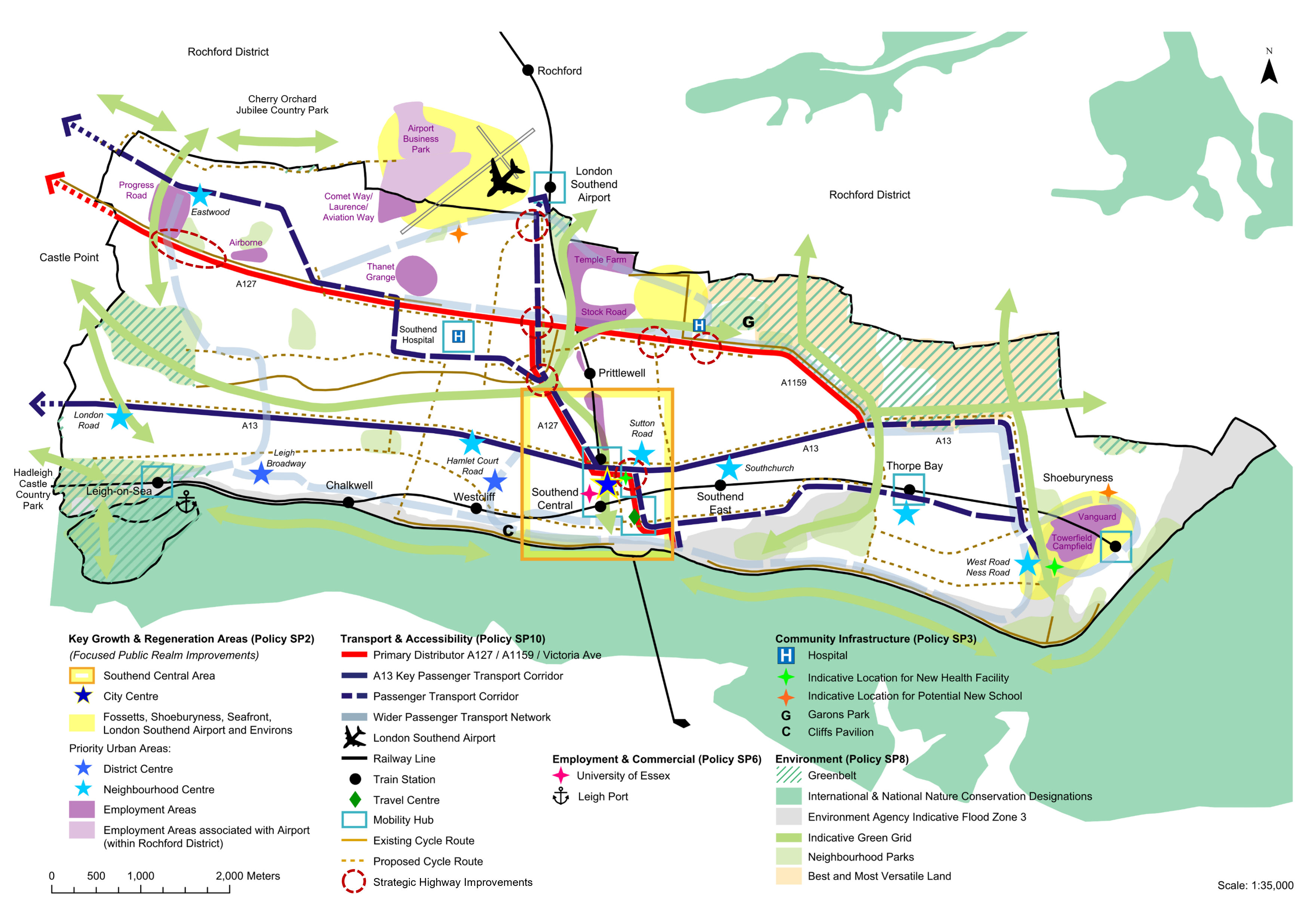
The provisions of the Strategic Policies contained in the Local Plan are summarized and depicted on Figure 3.4: Key Diagram.
Figure 3.4: Key Diagram
Draft Strategic Policy SP3: Securing and Improving Infrastructure
3.13 Infrastructure capacity and deficiency issues have been a recurrent theme in the public consultation responses to the Local Plan with comments from both the general public and infrastructure providers. Strategic Policy SP3 seeks to ensure that individual or cumulative new development does not have a negative impact on existing infrastructure, especially where it is operating at or close to capacity. Where existing infrastructure is shown to need upgrading the developer will be expected to work with providers to identify robust mechanisms to show how this will be addressed to include identified funding and implementation mechanisms by means of legal agreements as appropriate as part of an 'infrastructure led' approach to development.
3.14 New or improved infrastructure must be delivered first or at pace to meet the needs of new development. For larger development proposals that may be built out over a number of years this should take account of phasing to ensure that utilities and supporting services and facilities are in place to ensure new communities are sustainable and can thrive.
3.15 The Council will work with partners to ensure the provision of physical, social and environmental infrastructure. The Council will also continue to lobby central Government and relevant agencies for improvements to infrastructure provision which serve the city. This particularly applies to transport infrastructure and the need for improvements to the accessibility of the city to and from the wider region which are vital to the city's local business and tourism economy.
3.16 Infrastructure covers a wide variety of different types of provision including:
- Utilities - water, sewerage, storm water drainage, flood risk, electricity, gas, waste management and telecommunications;
- Transport – highways, public rights of way including cycleways, railways, other public transport (see Strategic Policy SP10 Transport and Connectivity);
- Education - early learning, primary and secondary schools, specialist schools, further and higher education including libraries;
- Health and Welfare - GP's, dentists, clinics, health centres, emergency services and hospitals; and
- Social - sports, leisure, parks and community facilities.
3.17 Good quality infrastructure is essential to people's quality of life, health and wellbeing. It is central to creating neighbourhoods where people want to live and to the effective operation of places.
3.18 Infrastructure in Southend varies in quality. This is partly a reflection of the age of some of the provision which needs upgrading, such as the Victorian sewers and some of the electricity networks. Parts of the sewer network encounter issues with exceptional flows which have resulted in overflow incidents on the foreshore. Elements of the electricity network in Leigh are also operating close to capacity. In contrast the digital network has recently been upgraded. Changing requirements, including in the health and education sectors, mean that existing estates must be adapted to meet the requirements of 21st century service delivery.
3.19 The Infrastructure Delivery Plan produced to inform this Local Plan sets out the issues in detail. The Infrastructure Delivery Plan highlights that some infrastructure provision is already near or exceeding capacity, this particularly applies to health and education facilities. It will therefore be essential that development is served by the necessary infrastructure by pursuing an infrastructure led approach, including the best use of existing assets. A list of potential projects from the IDP is listed in Appendix 4.
3.20 There has been a trend for several years towards centralisation and increasingly digitisation of service provision, both to improve the quality of services and reduce costs. This can however reduce accessibility to services for the most vulnerable. It is therefore important that new or replacement services are located in accessible locations, including the city's retail/ commercial centres and, where appropriate, that existing facilities are safeguarded.
Strategic Policy SP3: Securing and Improving Infrastructure
- Infrastructure needed to support development must be phased appropriately with the delivery of residential and other development to ensure that capacity is provided, and impacts are satisfactorily mitigated in a timely manner through an 'Infrastructure Led Approach'.
- During the plan period the following strategic infrastructure will be required to support development identified in Strategic Policy SP2: Spatial Strategy, namely:
- upgrades and capacity improvements to the highway network;
- measures to facilitate sustainable transport;
- expansion of existing schools and the provision of new education facilities*.
- healthcare and community facilities, including two new primary care facilities potentially within the City Centre and Shoeburyness;
- green space and recreation enhancement and provision;
- broadband telecoms; and
- utility improvements including flood prevention.
This has been informed by the preparation of a draft Infrastructure Delivery Plan (available on the local plan websitehttps://localplan.southend.gov.uk/evidence-documents.
- The delivery of development must be aligned with the provision of necessary infrastructure and not place a damaging burden on existing infrastructure.
- The Council will use planning obligations with landowners and developers to secure direct provision or financial contributions towards infrastructure necessary to support the Local Plan, including both on-site and off-site provision, to address the cumulative impacts of development on supporting infrastructure.
- The Council will review the Southend Community Infrastructure Levy to provide for infrastructure contributions that deliver both strategic and local infrastructure improvements.
- In appropriate cases the Council will seek to use compulsory purchase powers in order to assemble land to enable key development schemes and/ or improvements to infrastructure to proceed.
* the provision of a new school may be required subject to further testing. Two potential sites have been identified, one within Prittlewell and the other in Shoeburyness (Site Proposal HEA141 and HEA137 - see Chapter 12).
Have your say…
Please explain your answers
QSP123: Do you agree with draft Strategic Policies SP1 Spatial Principles; SP2 Spatial Strategy; and SP3 Securing and Improving Infrastructure? Please explain your answer with reference to relevant policy number.
3b. Strategic Policy Option: Question on whether to develop a new neighbourhood on land to the north of Southend?
The 'Preferred Approach with Options' document poses a question on whether to develop a new comprehensive neighbourhood on Green Belt land north of Southend. It is identified as an 'option' and comments are invited as part of the consultation as to whether the land should be allocated for development purposes or retained within the Green Belt.
To support the Government's objective of significantly boosting the supply of homes it is important that sufficient land is identified where it is needed through the plan making process.
Local Plans should be positively prepared seeking to meet objectively assessed needs. National planning policy dictates that housing need should be calculated using the national Standard Method. To 2040 housing need in Southend conducted using the national Standard Method is nearly 24,000 (or 1,405 homes per annum). This is more than 4 times recent delivery rates.
Draft Strategic Policy SP2 (Spatial Strategy) makes provision for at least 9,500 homes (around 550 homes per annum) that could be sustainably accommodated within the existing urban area of Southend outside the Green Belt and at Fossetts Farm by 2040. However, this results in a shortfall of over 14,000 new homes over this period compared to the national Standard Method for calculating housing need.
Due to this significant under-provision in new homes the Local Plan must consider the possible designation of land designated as Green Belt for development in line with national planning policy. Land within the Green Belt to the north of Southend straddling the administrative boundary with Rochford District is being promoted by developers. Such development could provide for a mix of new homes, commercial floorspace, strategic parkland and new infrastructure and services to support a new neighbourhood. However, it would still not meet housing need as calculated by national Standard Method for Southend.
National planning policy sets out that Local Plans should make provision for local housing needs (conducted using the national standard method) unless areas protected by the National Planning Policy FrameworkThe policies referred to are those in the NPPF relating to: habitats sites and/or designated as Sites of Special Scientific Interest; land designated as Green Belt, Local Green Space, a National Landscape, a National Park (or within the Broads Authority) or defined as Heritage Coast; irreplaceable habitats; designated heritage assets (and other heritage assets of archaeological interest referred to in footnote 75); and areas at risk of flooding or coastal change. provides a strong reason for restricting development in the area or any adverse impacts would significantly and demonstrably outweigh the benefits.
The 'Rochford District and Southend on Sea Joint Green Belt Study' undertaken in 2020 identifies the majority of Green Belt land to the north of Southend as continuing to serve the stated purposes of the Green Belt well, in particular by maintaining the openness of the countryside. The majority of the agricultural land to the north of Southend is also considered as high-grade quality.
Having regard to the above considerations, the main issue concerning the future designation of land north of Southend in this Local Plan is whether:
- the land north of Southend performs its Green Belt function well, in accordance with the stated purposes of the Green Belt as set out in the NPPF, and alterations would fundamentally undermine the purposes (taken together) of the remaining Green Belt such that it warrants retention of its Green Belt Status; or
- the outstanding identified housing need in Southend is such that it justifies exceptional circumstances to be applied in reviewing the Green Belt boundaries and that land north of Southend be designated for development purposes.
If the latter is considered appropriate, it is important that transport impacts arising from the development can be successfully mitigated National Planning Policy states that development should only be prevented or refused on highways grounds if there would be an unacceptable impact on highway safety, or the residual cumulative impacts on the road network, following mitigation, would be severe, taking into account all reasonable future scenarios., and along with other infrastructure requirements, including education and health, be funded and delivered at pace to ensure any new development is sustainable and its community can thrive.
Previous Local Plan consultations
3.21 In seeking to meet the national housing need figure for Southend, the two previous Local Plan consultation documents (the 'Issues and Options' and 'Refining the Plan Options') identified possible strategic options, namely:
- Option 1 - all development provided within existing urban areas;
- Option 2 - (including Option 1) most development provided within existing urban areas with some development on the urban edges on greenfield and agricultural land; and
- Option 3 - (including Option 1 and 2) and the potential provision of a new neighbourhood on predominately agricultural land, designated as Green Belt, to the north of the city with the possible potential to work with neighbouring Rochford District Council to develop a more comprehensive cross-boundary new settlement/s, subject to the outcome of detailed green belt studies.
3.22 Comments received on the possible development of Green Belt land as part of Option 3 were mixed. Whilst it was recognised that the land offered the opportunity for significantly contributing towards meeting projected housing needs and thereby ease housing pressures, it was recognised by a number of residents that it would result in the irreversible loss of the only extensive area of open countryside and Green Belt land in the city, contrary to the stated purposes of the Green Belt and would lead to the loss of agricultural land and potential mineral resources.
A potential new neighbourhood in the Green Belt - promoted by developers
3.23 Land designated as Green Belt to the north of Southend traversing the administrative boundary with Rochford District is being promoted by developers as part of the Local Plan preparation process to Southend City and Rochford District Councils for strategic scale development (Figure 3b.1). Such development could provide for a mix of new homes and new infrastructure to support a new neighbourhood. This could include a new highway access route linking to the strategic highway network and a new Country Park facility aligning the River Roach, but such provision would be dependent on land within the Rochford district. In support of this a 'Proof of Concept' has been provided by land promoters, which was published alongside the 'Refining the Plan Options' Local Plan document. This provided a 'developer' led view on one way in which the strategic scale new neighbourhood could come forward (available on the Council's website here https://localplan.southend.gov.uk/sites/localplan.southend/files/2021-08/Iceni%20Projects%20Response%20-%20Rochford%20and%20Southend%20Proof%20of%20Concept_2021.pdf).
Figure 3b.1: Land designated as Green Belt in Southend being promoted for development
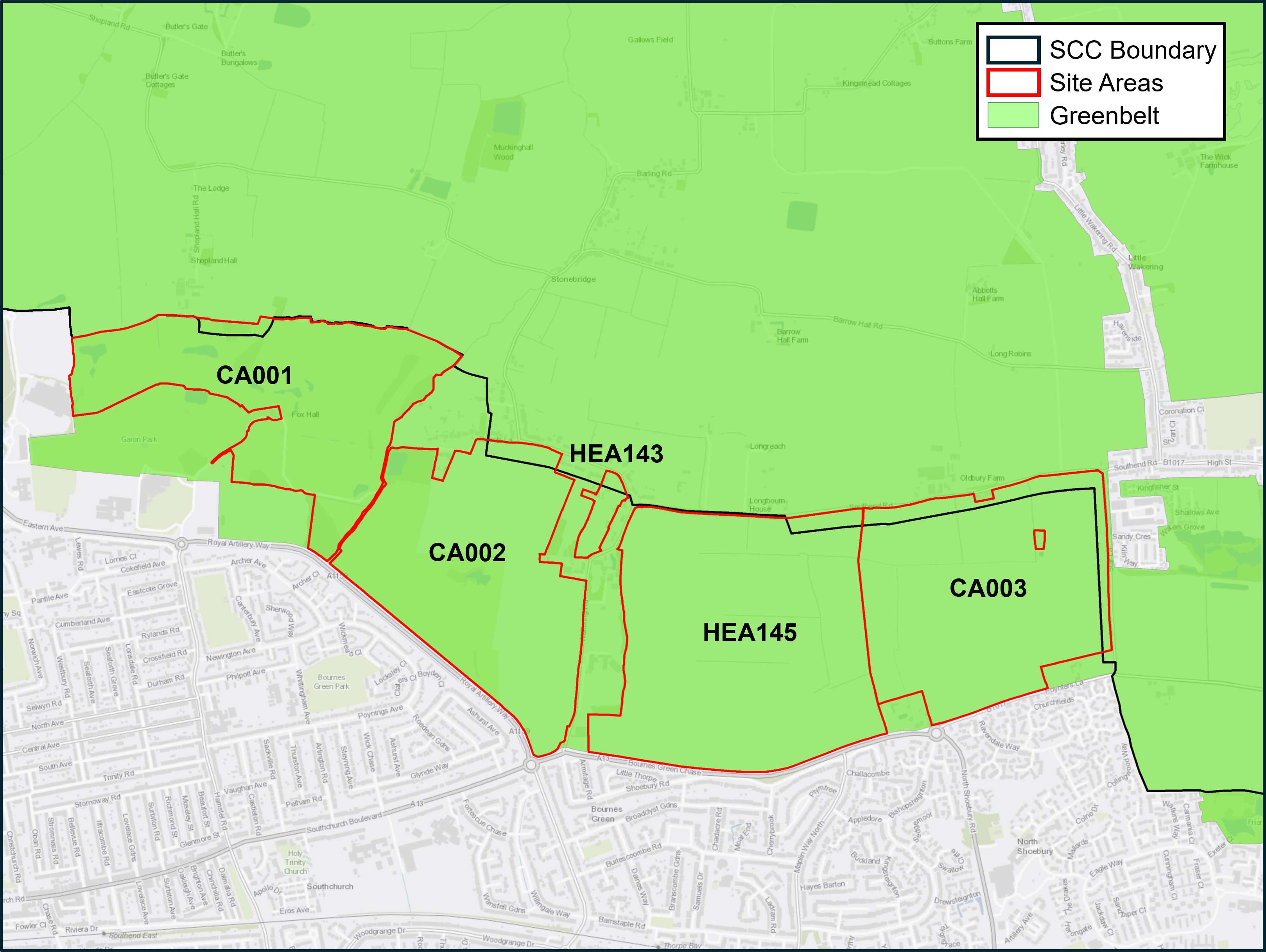 |
Key Existing Features: - Land designated as Green Belt - Existing golf course - High grade agricultural land - Limited public rights of way - Potential Mineral/ brickearth deposits - Existing hedgerows |
What a new neighbourhood on land designated as Green Belt in Southend as promoted could deliver
3.24 The land to the north of Southend within the Green Belt being promoted to the Southend Local Plan equates to 288 hectares. Development of this land in isolation from land within the administrative district of Rochford could deliver (Figure 3b.2):
- around 4,000 – 5,000 new homes of mixed size and type to include a high proportion of family and affordable housingA similar amount of new homes could be delivered within Rochford District as part of an expanded series of new neighbourhoods to the north of Southend. This will be considered as part of the Rochford District Local Plan.;
- supporting uses, including employment provision, health, school and community facilities;
- a network of formal green and blue Infrastructure such as public open spaces, sport, recreation and community space;
- the provision of sustainable urban drainage, landscaping and biodiversity measures; and
- new transport links and pedestrian and cycle connections and bus priority measures.
3.25 A new neighbourhood could be linked by a new multi-modal transport corridor. The corridor could feature varied open spaces acting as the central spine of the development, connecting to existing rail stations, the City Centre and the wider strategic transport network. Several new communities and centres would be arrayed along this central spine.
3.26 It should be noted that a new transport corridor, linking the new neighbourhood to the strategic highway network, would be dependent on land within the Rochford District being incorporated within the scheme. Delivery of such requisite transport improvements would therefore be dependent on the co-operation of Rochford District Council as the Local Planning Authority and Essex County Council as the highway authority.
3.27 The development of land north of Southend would be able to accommodate a range of housing needs, including the delivery of much needed family and affordable housing, but would still not meet the national Standard Method for calculating housing need for Southend. Neighbouring local authorities have continually been engaged about the constraints Southend faces and whether they would be able to make a contribution to Southend's unmet housing needs. However, all have indicated that they are similarly constrained and therefore unable to accommodate any requests from Southend, except Rochford District Council who are unable to confirm their position, as they are yet to reach the point of making strategic decisions in regard to their spatial strategy and where housing growth could sustainably be accommodated in the District.
Figure 3b.2: Key Diagram with potential New Neighbourhood on land north of Southend

Green Belt
3.28 The development of land north of Southend would also result in the irreversible loss of designated Green Belt land and agricultural land. National Green Belt planning policy is set out within the National Planning Policy Framework (NPPF).
"The Government attaches great importance to Green Belts. The fundamental aim of Green Belt policy is to prevent urban sprawl by keeping land permanently open; the essential characteristics of Green Belts are their openness and their permanence" (NPPF para. 142). The guidance provides that a change to Green Belt boundaries should only be made through the Local Plan process where exceptional circumstances are fully evidenced and justified (NPPF para. 145). "Exceptional circumstances in this context include, but are not limited to, instances where an authority cannot meet its identified need for homes… if that is the case, authorities should review Green Belt boundaries in accordance with the policies in this Framework and propose alterations to meet these needs in full, unless the review provides clear evidence that doing so would fundamentally undermine the purposes (taken together) of the remaining Green Belt, when considered across the area of the plan" (NPPF para. 146).
3.29 The Rochford District and Southend on Sea Joint Green Belt StudyRochford District and Southend on Sea Joint Green Belt Study, LUC, London, February 2020 Rochford District and Southend-on-Sea Borough Joint Green Belt Study identifies that the majority of Green Belt land to the north of Southend as continuing to serve the stated purposes of the Green BeltThe Green Belt serves five purposes as set out in the NPPF (paragraph 143):
to check the unrestricted sprawl of large built-up areas;
to prevent neighbouring towns merging into one another;
to assist in safeguarding the countryside from encroachment;
to preserve the setting and special character of historic towns; and
to assist in urban regeneration, by encouraging the recycling of derelict and other urban land. well, in particular by maintaining the openness of the countryside. The study notes that the release of the Green Belt land for a new neighbourhood within Southend would:
- represent significant urban sprawl northwards of Royal Artillery Way and the A13 onto Green Belt which is typically open and has a strong relationship with the wider countryside
- diminish the 'gap' between Southend with the inset villages of Great and Little Wakering to the east and create a more irregular Green Belt boundary when compared to the existing strong boundary;
- weaken the integrity of the neighbouring Green Belt to the north of the city within Rochford; and
- result in a predominantly 'high harm rating'Joint Green Belt Study 2020 – Definition of High Harm Rating: 'Where land makes a relatively strong contribution to multiple Green Belt purposes and where its release would weaken the adjacent Green Belt (for example by leaving a narrow gap between towns, or increasing its containment by urban areas), harm is likely to be high'. to the Green Belt, the harm generally increasing the greater the area of release, i.e. the further away from the existing urban edge the new Green Belt boundary is located.
3.30 The agricultural land to the north of Southend is predominantly graded as being of Grade 1 quality in the 'Agricultural Land Classification' (ALC)Agricultural Land Classification is a system used in England and Wales to grade the quality of land for agricultural use. The system classifies land into five grades. Grades 1, 2 and subgrade 3a are considered within the 'best and most versatile' land category in the current planning system.. The National Planning Policy Framework recognises the economic and other benefits of the best and most versatile agricultural land (paragraph 180) whilst the Government's 25-year planA Green Future: Our 25 Year Plan to Improve the Environment – Department for Environment, Food and Rural Affairs, February 2023. to improve the environment seeks to protect the best agricultural land and put a value on soils as part of our natural capital. Existing policy seeks to safeguard areas of quality agricultural land.
3.31 In addition, there are also mineral deposits on land north of Southend and existing policy seeks to safeguard these deposits from proposals that would result in the permanent sterilisation of workable or potentially workable brickearth deposits unless it can be demonstrated that the deposits are currently not commercially viable.
3.32 The NPPFNational Planning Policy Framework (NPPF, December 2024, paragraph 148 and Annex 2, Glossary). also provides that in reviewing Green Belt land to meet their own housing need, Councils should give priority to previously developed land within the Green Belt and then consider 'grey belt' land that does not strongly contribute to any of three of the five stated purposes of the Green Belt, namely a) to check the unrestricted sprawl of large built-up areas; b) to prevent neighbouring towns merging into one another or d) to preserve the setting and special character of historic towns (see footnote 7 above). Such provisions exclude certain areas such as those at risk of flooding or designated heritage assets. Given that land north of Southend is predominantly in agricultural use and that the findings of the Rochford District and Southend on Sea Joint Green Belt Study found that the land continues to serve the stated purposes of the Green Belt well, particularly in relation to criteria a), checking the unrestricted sprawl of the Southend urban area, it is considered that the 'grey belt' definition does not apply in these circumstances.
Summary
3.33 To facilitate the delivery of a new neighbourhood, a range of complementary services and other uses would be required, including but not limited to improved transport and access, new schools, health facilities, parkland and green space and other supporting infrastructure. The pros and cons of a new neighbourhood on Green Belt land north of Southend are summarised in Table 3b below.
Table 3b: Summary - Potential Positive impacts and potential harm of a new neighbourhood within Southend on land designated as Green Belt
|
Potential Positive Impacts |
Potential Harm |
|
Provision of a thriving new community on land to the north of Southend providing a significant number of new homes (4,000 – 5,000 homes within Southend)* that could help ease local housing pressure. |
Loss of Green Belt, countryside and openness around Southend. Potentially weaken Green Belt to the north of Southend and ability to check urban sprawl. |
|
Provide new education, health and community services and facilities within easy reach of new homes. |
Would still not meet Southend housing needs in full over the plan period. |
|
Provision of new transport corridor and other connections for walking and cycling, public transport and private motor vehicles. |
Delivery of requisite transport corridor and link road would need to be provided upfront and reliant on land within Rochford District and the support of Rochford District Council and Essex County Council. |
|
Provision of new public open spaces and new Country Park. Enhance biodiversity across the area through planting and establishing new and improved green spaces. |
The extent of a new Country Park would be dependent on land within Rochford District. |
|
Will comprise a high proportion of new affordable homes. |
Would result in the permanent loss of agricultural land in this locality. |
|
Provision of a high proportion of much needed family housing. |
Would likely result in the sterilisation of mineral deposits (brickearth) subject to prior subtraction. |
|
Attract significant investment and new jobs to Southend during construction phase |
May direct investment away from the existing urban area and undermine regeneration, potentially in Southend City Centre |
|
Provision of new local centres and commercial premises. |
Delivery would take many years and may disrupt existing communities. |
|
Capacity for development to provide a more cohesive landscape character, particularly around Fossetts Way/ Garon Park. |
Risk of reducing clear separation between distinct characters of urban Southend and village of Great Wakering and ability to prevent their mergence. |
*A similar amount of development could be provided within Rochford, subject to the preparation of the Rochford Local Plan.
Have your say...
Please explain your answers
Q3b.1a: Do you think land north of Southend currently designated as Green Belt should be allocated for mixed-use residential-led development, including new parkland and associated services and infrastructure to contribute to meeting identified housing needs?
OR
Q3b.1b) Do you think land north of Southend currently designated as Green Belt should be retained as Green Belt?
If you answered 'Yes' to Q3b.1.a
Q3b.2a: Do you think that:Green Belt land north of Southend should only be released in conjunction with adjoining land within the Rochford District to provide for a comprehensive new neighbourhood and new highway access to the A127?
OR
Q3b.2b: Do you think that Green Belt land north of Southend should be released for housing development regardless of whether adjoining land within the Rochford District is made available? (this could preclude the provision of a new highway linking to the existing strategic road network and the provision of a new Country Park facility).
Guiding Principles and Expectations for a possible new neighbourhood on land north of Southend
3.34 If it is deemed appropriate to pursue the provision of a new neighbourhood on Green Belt land north of Southend following this stage of Local Plan consultation, it will be important to incorporate a Strategic Policy in the next stage of Local Plan preparation, setting out guiding principles and expectations to guide the new development scheme.
3.35 We need your views on what policy criteria should be included to guide the design of a new neighbourhood if this option is in the next stage of the Local Plan.
3.36 Strategic Policy Option 3b below sets out the range of different land uses, services and facilities that would be needed for a new neighbourhood to be sustainable, vibrant and thrive. Figure 3b.3 provides a guide for the proportion of land given over to certain uses.
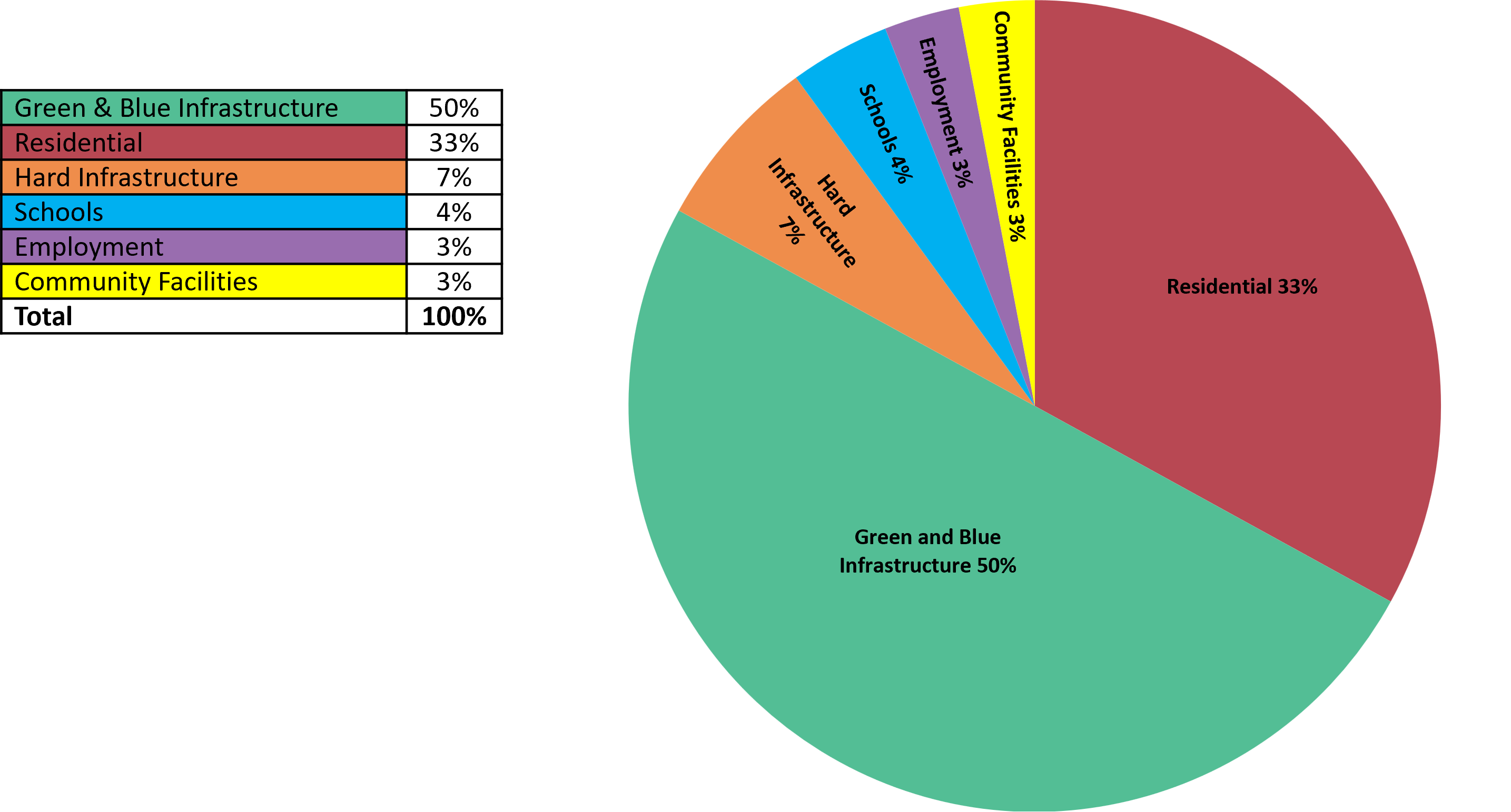
Figure 3b.3: Guide to the proportion of different land uses for a potential new neighbourhood within Southend
Southend Land Budgets in Large Scale New Developments. Sets out benchmarks for land use budgets based on 16 examples of large-scale developments.
For example, 50% of the land being promoted would be expected to be Green and Blue Infrastructure. This includes a wide range of features, such as parks, open spaces, playing fields, allotments, woodland, road verges and water features, sustainable drainage, lakes and ponds. This does not comprise private/ communal residential gardens or green roofs and walls (as these are included within the residential parcel area calculation).
3b. Strategic Policy Option: Guiding Principles and Expectations for a possible new neighbourhood on land north of Southend
- The strategy option should provide for a vibrant new community, including between 4,000 – 5,000 new homes, employment floorspace, new parkland and associated infrastructure and services on land to the north and within Southend. This could form part of a wider proposal on adjacent land within Rochford District.
- Developers must produce a Strategic Master Plan, which is in general conformity with the adopted Local Plan and any supplementary planning documents, in partnership with the Council and other stakeholders, such as Rochford District Council, Essex County Council, the local community, infrastructure providers and statutory bodies.
- Infrastructure, including social infrastructure, must be plan led and delivered at a pace which meets the needs of the proposed development throughout the construction of the site. Developers will be expected to contribute to the provision of strategic highway and other infrastructure requirements set out in the Infrastructure Delivery Plan. This includes, but not limited to:
- provision of strategic parkland and an integrated network of Green and Blue Infrastructure, such as public open spaces, sport, recreation and community space, allotments, sustainable urban drainage, landscaping and biodiversity measures having regard to the South Essex Green and Blue Infrastructure Study (SEE Park).
- provide highway solutions to address the impact on the wider strategic road network, including junction and capacity improvements and the provision of a new multi-modal transport corridor linking the new neighbourhood to the strategic highway network (A127). Parts of the new corridor would be located within the Rochford/Essex administrative area. The design and development of the route will therefore need to be progressed collaboratively.
- include the provision of walk/ cycle/ bus/ car access throughout the site and ensure the successful integration with the existing transport network with a particular focus on direct and convenient access to the City Centre and nearby train stations, including London Southend Airport train station.
- provide a broad range of health care facilities including GP's and enhancing community health infrastructure and acute care facilities.
- provision of education facilities (estimated to include one primary school and one through school) together with childcare and Early Years.
- multi-purpose community space and facilities, including space for creative industries, youth services and play equipment.
- satisfactory water supply and wastewater network infrastructure improvements for occupants.
- The development must:
- provide sustainable, integrated and well-planned development that reflects the overarching principles of the Southend Local Plan and supplementary design guidance for the area and incorporate a broad range of uses, infrastructure, public green space and services and a new Country Park facility having regard to Figure 3b.3.
- be designed sensitively to take full account of topography and landform and to successfully integrate with the existing urban areas of Southend.
- provide a range of high-quality new homes of mixed size and type, including a high proportion suitable for families and 40% affordable housing.
- include appropriate retail and town centre uses to support the local population, through the provision of high-quality walkable local centres, incorporating an element of employment floorspace targeted at small and medium enterprises.
- provide opportunity for local jobs, skills and training during development.
- be energy efficient achieving Net Zero carbon in operation (in line with Option 2 within draft Policy DM9.1)
- provide sustainable drainage solutions and flood mitigation measures and be flood resistant and resilient.
- deliver an overall net gain of at least 10% for biodiversity in line with Policy DM8.5
- provide and contribute to public art within the development.
- include measures necessary to safeguard wildlife sites.
- include a Heritage Impact Assessment to inform the design of the development to ensure heritage assets within and surrounding the site are conserved or enhanced and the proposed development will not cause harm to the significance of a heritage asset or its setting.
Have your say…
Please explain your answers
Q3b.3: Do you agree with the above guiding principles?
Q3b.4: Do you think other criteria should be incorporated? (please specify)
Note: The draft criteria will only be used to inform a policy framework should the strategy option to develop Green Belt land north of Southend be included in the next stage of the plan.
Why We Have Taken This Approach
Achieving a Sustainable Balance
3.37 Southend is a city with significant opportunities, and it is important that the new Local Plan recognises, embraces and promotes these.
3.38 However, it is also a city that faces significant challenges which need to be addressed in the Local Plan. These particularly relate to identifying future development needs in the face of limited land resources, providing the necessary infrastructure to support growth, and regenerating and refocussing its city Centre whilst respecting the city's character and distinctiveness and safeguarding and enhancing its natural environment.
3.39 This requires careful planning, and this Preferred Approach version of the Local Plan seeks to achieve an appropriate sustainable balance between allocating and identifying opportunities for future development and growth whilst protecting the city's character and valuable natural assets. The Local Plan embraces the concept of facilitating complete, compact and connected neighbourhoods across the city, where everyday essentials and services are easily accessible and thereby help promote healthy lifestyles, boost local economies and increase opportunities for social interaction. It also seeks views on whether a new neighbourhood on Green Belt land north of Southend should be pursued in the next stage of Local Plan preparation.
3.40 An integral part of achieving this is the provision of infrastructure which is fit for purpose to meet current and future development needs and growth in the city. The Council is preparing an Infrastructure Delivery Plan (IDP) to ensure that key infrastructure requirements, including planned projects, are clearly identified and deliverable. The Infrastructure Delivery Plan sets out the anticipated infrastructure requirements and funding mechanisms for the Plan period. The Council will work with providers and partners, as appropriate, to facilitate the delivery of key projects. A list of potential projects from the IDP is listed in Appendix 4.
4. Enabling Healthy Lifestyles and Wellbeing
A CITY THAT IS HEALTHY AND SAFE
4a. This chapter looks at enabling healthy lifestyles and wellbeing together with the provision of necessary community infrastructure. It sets out our approach in supporting our communities with the facilities and services they need including for education and health, sports and recreation.
Strategic Policy
Where we are now
4.1 Southend faces a number of significant challenges in relation to the health and wellbeing of its residents. There are marked inequalities between different areas of the city. Life expectancy is around 10 years lower in the most disadvantaged areas compared with the least disadvantaged, and this is worse than the average for EnglandPublic Health Outcomes Summary for Southend May 2025 Public Health Outcomes Framework - at a glance summary. The proportion of older and younger people has also grown relative to the general populationSouthend Population change, Census 2021 www.ons.gov.uk/visualisations/censuspopulationchange/E06000033/, meaning there will be greater demands on local services and the need to plan for inclusive environments that meet the needs of all. As the population grows in Southend so does the demand on health, social care and community services, together with sport and recreation facilities.
4.2 The existing health care model of treating ill health has evolved towards a more holistic, preventative approach to supporting people with all aspects of their health and wellbeing throughout their lifetime, by GPs and other health and social care professionals, with a focus on reducing health inequalities. The links between spatial planning and health are well recognised by health and planning professionals.Spatial Planning for Health https://assets.publishing.service.gov.uk/media/5b59b090e5274a3ff828c70c/spatial_planning_for_health.pdf A better quality natural and built environment will lead to improved health and wellbeing for our residents. Strategic Policy SP3: Infrastructure sets out the broad framework for securing infrastructure, including health and social care facilities and green infrastructure.
4.3 Southend's strategic health priorities are underpinned by local health evidence,Annual Public Health Report and engagement with a range of key stakeholders and the local community. Spatial planning has a key role in creating and maintaining healthier environments and making a healthy lifestyle as easy as possible for example by:
- using active environment design and spatial planning principles to support healthy lifestyles;
- maintaining and developing safe spaces for play, sport and social interaction that are accessible for all;
- using cultural spaces, such as parks to access the arts and heritage, and by doing so, increasing physical activity;
- developing integrated active travel networks, which are safe and connected for walking, cycling and for public transport;
- designing homes to be flexible for residents' use at all stages of their lives, including provision for extra care and other specialist housing;
- making better use of our existing natural and built environments to encourage healthy lifestyles for all;
- continuing to avoid or mitigate air, noise, water, soil pollution and flood risk, so our surroundings are clean and green.
Where we want to be
Strategic Objective 1
Strategic Objective 2
Strategic Objective 3
Strategic Objective 4
Key Supporting Documents
Key supporting documents that underpin the policies are available at localplan.southend.gov.uk/evidence-documents
Did you know
- About a third of adults in Southend are physically inactive – a quarter of adults complete less than 30 minutes moderate activity per week.Active Lives Adult (Sport England) November 2022-2023
- Around 2 in 5 children leaving primary school (Year 6) are considered to be overweight or living with obesity.National Child Measurement Programme 2021-2022 (OHID)
- Southend has above average incidence of people in poor mental and physical health.
- Southend has above average proportion of older residents – over 65's will increase from 19% to around 25% of population by 2031.Southend Adult Social Care JSNA (2022)
- 10-year gap in life expectancy between residents living in the most and least deprived neighbourhoods.
How we are going to get there
Strategic Policy SP4: Enabling Healthy Lifestyles & Wellbeing
- New development must contribute to healthy, inclusive and safe places, which enable and support healthy lifestyles and address health and wellbeing needs in Southend, having regard to the latest Southend Joint Strategic Needs Assessments and Annual Public Health Report.
- New development should demonstrate that it will not jeopardise the city's ability to improve the education attainment, health and well-being of local residents and visitors to Southend.
- The Council will support development that enhances the primary care network to support easy access to services and reduce health inequalities, enabling the broader integration of health and social care services in collaboration with the NHS and partner organisations.
- A desktop Health Impact Assessment (HIA) will be required (see Appendix 5) for:
- developments of 50 or more dwellings, and/or 5000sqm or more non-residential floorspace;
- developments where an Environmental Impact Assessment is required;
- where a large House of Multiple Occupation (HMO)* is proposed.
If the desktop HIA shows any significant issues a full HIA may be required having regard to local health evidence and how any potential health impacts can be mitigated.
- Planning applications for hot food takeaways and fast food outlets will be refused where they are located within 400 metres from a school (measured from the centre point of the school site), unless the location is within a designated City, District or Neighbourhood centre.
- To facilitate healthy lifestyles, new development must be in general conformity with all policies within the Local Plan with particular emphasis to those set out in Policy Table SP4.1
*7 or more unrelated people living together in an HMO (Sui Generis Use Class)
What it will look like
4.4 The links between Local Plan policies and health and wellbeing are cross-cutting across a range of social, economic, and environmental issues. The Local Plan policies most relevant to health and wellbeing are listed below:
Policy Table SP4.1: Southend Local Plan policies influencing health and wellbeing
|
Why we have taken this approach
4.5 Spatial Planning influences the health and wellbeing of Southend's residents by affecting the wider determinants of health.Dalgren and Whitehead, 1991 The Southend Joint Strategic Needs Assessmentshttps://southend-jsna-southend.hub.arcgis.com/ and Annual Public Health Reporthttps://annual-public-health-report-southend.hub.arcgis.com/ set out the main issues relating to the health and wellbeing of Southend's residents and the challenges and opportunities to improve this.
4.6 The Local Plan can have a positive impact by ensuring developments are located to support active lifestyles, provision of homes that meet people's needs through all stages of their lives, encouraging local jobs and services within easy reach of homes, maintaining access to fresh food and community food growing sites, and requiring the layout and design of buildings and spaces to support good health and wellbeing.
4.7 Health Impact Assessments (HIAs) provide a way to assess the effects on health of a development proposal and mitigate any impacts so that health inequalities are reduced, and wellbeing improved. The outcome of these actions should be clearly identifiable within the planning application. For all developments requiring an Environmental Impact Assessment, Health Impact Assessment must be incorporated into this assessment.
4.8 A desktop Health Impact Assessment will be required to be submitted with all proposals for 50 or more dwellings, and/or 5000sqm or more commercial floorspace for the Council to understand the potential impacts of the development on the health and wellbeing of the local population or particular groups within it (see Appendix 5). This will also be a requirement for Large HMOs, including applications to change use from a Small HMO to a Large HMO.
4.9 HIA should be undertaken early in the design process to ensure that any potential health benefits can be maximised, and any potential harms mitigated. Further guidance on HIAs is available from The Office for Health Improvement and Disparities (OHID). The assessment should highlight any potential impacts on health and wellbeing and how these can be mitigated, and where appropriate secured by planning condition.
4.10 A statement must be provided which initially identifies potential negative and positive impacts and then summarises how negative impacts have been minimised and how positive impacts have been maximised, for both new occupiers and existing communities.
4.11 On occasion, there may be a requirement for a full HIA to be completed, for example if the completed desktop HIA indicates that the proposal is likely to have a significant impact on health and wellbeing. If this is the case, the Council will confirm this in writing.
4.12 NPPF paragraph 97 requires that Local Planning Authorities "refuse applications for hot food takeaways and fast food outlets: a) within walking distance of schools and other places where children and young people congregate, unless the location is within a designated town centre; or b) in locations where there is evidence that a concentration of such uses is having an adverse impact on local health, pollution or anti-social-behaviour".
4.13 The Southend and Rochford Settlement Role and Hierarchy StudySouthend Settlement Role and Hierarchy Study 2020 identifies walking and cycling catchments for a range of day-to-day services. For example, 400 metres equates to approximately five minutes walking, and 1,250 metres equates to five minutes cycling, based on averages for able bodied peopleSee for example, Institution of Highways and Transportation, 2000, guidelines for providing for journeys on foot. The study provides average walking distances from home to schools. These have been used to establish an appropriate buffer, within which hot food takeaways and fast-food outlets will not be permitted, unless they would be located within a designated City, District or Neighbourhood centre.
Have your say…
Please explain your answers
QSP4: Do you agree with Strategic Policy SP4: Enabling Healthy Lifestyles and Wellbeing? Please explain your answer.
Providing & Protecting Community Facilities – development management policy
Reference to Strategic Objective and Strategic Policies
Strategic Objective 1
Strategic Objective 2
Strategic Objective 3
Strategic Objective 4
Strategic Objective 21
Policy SP3 Securing and improving Infrastructure
Why we need this Policy (Justification)
4.14 Community facilities are essential both to residents' quality of life and to the sustainability of the city. They contribute to the provision of 'complete neighbourhoods' so that residents can access facilities and services they require easily and conveniently.
4.15 With changes in society and service provision it is necessary to ensure that existing facilities are protected, and new facilities meet the needs of residents. There are trends in some sectors, such as health, for a move towards consolidating services at 'Hub' locations. This offers benefits in the quality of care but needs to be planned carefully to ensure that it is accessible to all users.
How the Policy Works
4.16 Community facilities cover an important range of facilities and services, including health and education facilities, community centres/ halls, libraries, places of worship, public houses (pubs), theatres and other cultural facilities.
4.17 The policy seeks to safeguard existing community facilities. In some cases, Permitted Development rights allow changes without planning permission being required. However, where planning consent is required to change use from community facilities, the Council will expect full justification to be provided for why the facility cannot be retained, and is no longer in demand, viable or suitable for its continued permanent authorised use, as set out in the policy criteria tests within Policy DM4.1, and in accordance with Appendix 6, Part A. This should include a minimum of 1-year active marketing exercise where the site/ floorspace has been offered for sale or letting on the open market at a realistic price and that no reasonable offers have been refused.
4.18 New or enhanced community provision should be located where it is accessible by a variety of transport modes including public transport with a good quality of service.
4.19 Policy DM4.1 also includes criteria for managing proposals relating to burials and cremations. Sports facilities are covered separately in Policy DM4.2.
4.20 The Council provides and maintains public cemeteries, however, there is no statutory duty to provide burial space. The Council has recently refurbished Southend crematorium, however, like many authorities nationally, burial space in Southend is rapidly running out. Given that greenspace that might be suitable is limited in the urban area it will be necessary to look at alternative options. Cemeteries and Burial Grounds also form part of the city's green infrastructure network (and have a multifunctional role including for biodiversity and for some spaces, recreation (see Strategic Policy SP8).
Policy DM4.1: Providing & Protecting Community Facilities
- The Council and its partners will encourage the creation of healthy and complete neighbourhoods by supporting a network of community facilities by:
- supporting provision of new and or enhanced facilities that are well designed, accessible to all and which enhance service provision, and the following considerations are addressed to the satisfaction of the Council:
- impact on access and highway network;
- impact on neighbours;
- impact on accessible green infrastructure.
- protecting existing community facilities that still serve, or have the ability to serve, the needs of the community. This includes community centres, libraries, Public Houses (Pubs), places of worship, health facilities, education, early years, theatres and other cultural facilities. Any loss of facilities will need to demonstrate to the satisfaction of the Council that:
- the local community no longer needs the facility, and adequate alternative provision has been made, or is already available, in the neighbourhood or local area*; or
- it has been demonstrated that the use is no longer financially viable now and could not be made viable in the future (in accordance with Appendix 6, Part A)*;
- proposals for residential development that could put at risk the continued use of existing community facilities are subject to the agent of change principle (Policy DM9.3.7).
*As set out in Appendix 6 Part A, This should include a minimum 1-year active marketing exercise where the site/ floorspace has been offered for sale/ letting on the open market at a realistic price and that no reasonable offers have been refused.
- The Council will, subject to provision of suitable evidence on environmental impacts, support additional space for funerals including burials and cremations and associated infrastructure. New forms of funeral, including "green burials", will be supported where these avoid risk to groundwater, have acceptable access and form part of the broader green infrastructure network. Any proposals for such facilities in the Green Belt would need to meet relevant national planning policy and preserve openness.
*In relation to health and education facilities this should align with a strategic understanding of needs and estate management plans.
Have your say…
Please explain your answers
Q4.1: Do you agree with draft Development Management Policy DM4.1: Providing and Protecting Community Facilities? Please explain your answer.
Sport & Recreation – development management policy
Reference to Strategic Objective and Strategic Policies
Strategic Objective 1
Strategic Objective 2
Strategic Objective 3
Strategic Objective 4
Key Supporting Documents
Please refer to localplan.southend.gov.uk/evidence-documents particularly under the header 'Providing community services and infrastructure'.
Southend Playing Pitch Strategy and Southend Built Facilities
Why we need this Policy
4.21 Southend has a good range of indoor sports facilities that cater for recreational through to regional level performance in sports. Approximately 94.6% of Southend's population live within 800 metres of a sports facility, and around 96% of the population can access these facilities within a 20-minute walk.
4.22 The Built Facilities Strategyhttps://localplan.southend.gov.uk/evidence-documents found that:
- Indoor sports provided for include tennis, indoor bowls, diving, swimming, futsal, basketball, badminton, gymnastics, and volleyball, although the Council has limited direct influence over the programming of facilities and more could be done to widen community access, e.g. use of indoor facilities within schools;
- Sports Hall supply is low at 3.9 courts per 10,000 residents, limiting the capacity and potential expansion of clubs catering for basketball, netball, badminton and futsal;
- Swimming Pools are well used and operate above Sport England's comfort benchmark rating, however there is a shortfall in pool provision equating to around 9.3 lanes of a 25m pool (based on 2018 study);
- Growth in girls' participation in sport e.g. basketball and futsal will require further provision for indoor space over the plan period;
- The health and fitness market has mainly good and above average quality of provision with a good range of price points;
- Active Southendwww.activesouthend.com are delivering a range of health and wellbeing activities at indoor and outdoor sites in the area.
4.23 The Built Facilities Strategy recommended that the Council work with partners to create opportunities to accommodate additional swimming and sports hall provision, and continue multi-agency work to support an increase in opportunities for physical activity and sport. Opportunities should also be sought to identify ongoing investment, maintenance, and refurbishment requirements to protect and improve existing sports facilities, including the Council's own assets, and to ensure all school sports facilities are made fully available for community use.
4.24 The Playing Pitch Strategyhttps://localplan.southend.gov.uk/evidence-documents found there was a shortfall in provision for pitches for football within Southend Central area, and for Rugby and Cricket, with a projected shortfall in 3G pitches of 6 full size football pitches and one full size Sand artificial grass pitch. For the most part, shortfalls in provision can be met by better utilising current provision or pitch re-configuration. An increase in 3G provision could also help reduce grass pitch shortfalls for football and rugby. Since the study was published, one 3G pitch has been completed at Garon Park with further provision planned.
4.25 There were also shortfalls in quality of provision for both indoor sports and playing pitches. Recent quality improvements include investment in tennis courts within public parks, with new nets, lighting and secure access, and conversion of tennis courts at Garon Park to Padel courts.
4.26 In terms of participation in sport, around a quarter of adults aged over 16 are completing less than 30 minutes moderate intensity activity per week, and the proportion of residents aged 65 and over is expected to increase by 57.3% by 2037.2011 Census Providing sufficient opportunities for residents to engage in both formal and informal sports and physical activity will enable residents to Live Well and Age Well, contributing to reduced childhood and adult obesity levels and providing associated benefits for mental health, improved general health and wellbeing and reduced health inequalities.
4.27 The Built Facilities Strategy and Playing Pitch Strategy for Southend (2018) each set out an Action Plan with high, medium and low priority for investment in a range of sports. The Council works with Sport England and the Sports' governing bodies to update the action plans for each sport, and to further the provision of sports and recreation facilities in the city, based on local priorities.
4.28 Policy DM4.2 seeks to protect existing sports and recreation facilities, address existing qualitative and quantitative deficiencies and ensure that new developments fully contribute to meeting the demand they generate. The scale of new dwellings proposed in the Local Plan will be taken into account in updating the Built Facility Strategy and Playing Pitch Strategy, to understand the demand on the city's sport, recreation and open space facilities.
How the Policy Works
4.29 The loss of existing facilities will not be permitted unless they have clearly been shown to be surplus to requirements. Deficiencies should be remedied through provision of open space, sports and recreation facilities, and through qualitative improvements to existing facilities, where planning permission is granted for new developments (especially housing).
4.30 New investment should be focussed within existing sport facilities and/ or where it would address identified sport specific deficiencies, in accordance with the priorities set out in the Built Facilities Strategy and Playing Pitch Strategy or subsequent updates.
Policy DM4.2: Sport & Recreation
- New or replacement sport and recreation facilities, or extensions to existing facilities, should be accessible by sustainable transport. Priorities for sport facilities will be included within the Infrastructure Delivery Plan.
- Development involving the loss of outdoor sports facilities, play space for children, or land and buildings of value for sports and recreation, will only be permitted if it can be demonstrated that:
- there is a surplus of similar facilities in the area and the loss would not adversely affect the existing and potential future recreational needs of the local population; or
- suitable replacement facilities of at least equivalent quantity, quality and community value would be provided elsewhere and serve the local population in locations that are accessible by sustainable transport.
- Planning Obligations will be sought where new development would create or add to local deficiencies to provide the additional facilities necessitated by the new development (see Strategic Policy SP3).
- To remedy deficiencies in indoor sports facilities set out in the Built Facilities Strategy (2018) and subsequent updates, priority will be given to the provision of indoor sports facilities which are easily accessible to local residents by sustainable transport, walking and cycling
- The improvement and expansion of swimming pool facilities in the city will be supported. Permission will not be granted to proposals involving the loss of such facilities unless adequate alternative provision is made in a convenient and appropriate location, or there is found to be a surplus of similar facilities in the area and the loss would not adversely affect the existing and potential recreational needs of the local population.
- Proposals for improvements to the quality of existing golf courses will be supported where these broadly accord with the spatial strategy and strategic priorities set out in the latest Playing Pitch Strategy and subsequent updates.
Have your say…
Please explain your answers
Q4.2: Do you agree with draft Development Management Policy DM4.2: Sport and Recreation? Please explain your answer.
5. Homes
A CITY OF OPPORTUNITY
5a. This chapter looks at planning for homes and employment, including the need for new homes and new jobs resulting from future population growth and how they will be distributed across the city.
Strategic Policy
Where we are now
5.1 The key issues that the city faces in terms of planning for new homes are as follows:
Context
- Housing in Southend, and South Essex as a whole, has become less affordable in recent years compared to the national average. Indeed, for many it is simply unaffordable.
- Southend is a densely populated urban area with limited supply of both brownfield and especially greenfield land for new development.
- The need to provide for an annual increase in housing delivery, whilst recognising limited land availability and the need to provide for supporting infrastructure, employment, education, health, green spaces and other community facilities to ensure good quality of life for residents.
- Growth needs to be sustainably managed across the city so it contributes to the vitality and viability of centres, whilst not undermining the city's valued character and heritage.
- It is vital that future growth in Southend is infrastructure led.
Housing Need
- The need for new homes in Southend is high, the national standard method for calculating housing need is more than 4 times annual delivery rates and that of previous adopted housing targets for the city.
- There is a need to safeguard and increase the delivery of three bed (and larger) homes to cater for families, as well as providing for a range of different sized housing, including accommodation to meet Southend's growing proportion of older people.
- The need to deliver more affordable housing, whilst ensuring development remains viable.
- Houses in Multiple Occupation (HMOs) are a feature of the city, especially in Southend Central, Southchurch and Westcliff. Such properties perform a useful role in providing affordable rented accommodation. However, concentrations of HMOs, especially when these are poorly maintained, can result in localised adverse impacts.
- Evidence does not indicate a requirement for gypsy or traveller pitches.
Past Delivery
- Between 2001-2023, approximately 7,550 new homes were built in the city (340 per annum), representing nearly a 10% increase in total stock across the city. This overall provision exceeded the figure of 325 homes per annum set out In the Core Strategy (2007). It is, however, significantly below the Government Standard Methodology for calculating housing need of 1,405 homes per annum.
- Of the 7,550 new homes built between 2001 – 2023:
- 96% of new homes were built on previously developed land.
- Around three quarters of new homes were flats (75%), reflecting the dense nature of the city and the conversion of redundant office blocks especially on Victoria Avenue.
- 28% were 1 bed, 50% were 2 beds, 14% were 3 beds and 8% were 4 or more beds.
Where we want to be
Strategic Objective 1
Strategic Objective 2
Strategic Objective 3
Strategic Objective 6
Strategic Objective 9
Strategic Objective 13
Strategic Objective 14
Strategic Objective 19
Strategic Objective 21
Key Supporting Documents
5.2 Key supporting documents that underpin the policies are available on the Council's Evidence Documents | Southend Local Planhttps://localplan.southend.gov.uk/evidence-documents. This is supplemented by key housing statistics including those published by the Government, the Office for National Statistic (ONS), Valuation Office Agency (VOA) and the Authority Monitoring ReportAuthority Monitoring Report.
How we are going to get there
Strategic Policy SP5: Homes
The Delivery of new homes
- Provision is made for 9,500 net additional homes to 2040, distributed as follows:
- Southend Central Neighbourhood (incorporating City Centre and Central Seafront): 4,000
- a new community at Fossetts Farm: 1,200
- the other neighbourhoods of Southend: 1,900
- intensification across the city (windfall): 2,400
This requirement will be phased so a greater proportion of homes are delivered in the latter half the plan period. This will help ensure the provision of requisite infrastructure.
- This will be achieved by:
- promoting the efficient use of land/ sites across the city by optimising densities, particularly in highly accessible locations and those with the most capacity to accommodate new homes, whilst respecting the local distinctiveness of Southend's Neighbourhoods and protecting the city's built, natural and historic environment; (see DM7.2 and DM7.3)
WITH PLANNING PERMISSION
- the implementation of existing planning permissions to deliver 4,000 new homes.
WITHOUT PLANNING PERMISSION (see chapter 12 and policies map for all site proposals)
- Allocating land for development to deliver an additional 1,900 new homes by 2040.
- identifying Broad Locations/ Opportunity Sites to deliver an additional 1,200 new homes by 2040, including underutilised employment sites.
- positively considering proposals for the provision of homes from other sites (windfall development) to deliver 2,400 new homes.
- requiring residential development schemes within designated centres to include replacement and/ or new retail and commercial uses, in order to safeguard, maintain and enhance the vitality and viability of these shopping and commercial areas.
- requiring a vibrant mix of employment, residential and community uses on larger sites, to support greater economic and social diversity and sustainable transport principles by creating places where residents can meet their daily needs within a short walk/ cycle if they so wish.
The type of new homes
- In order to provide a choice of housing the Council will seek to deliver 9,500 new homes by:
- delivering of a wide choice of high-quality, well-designed homes that contribute to the creation of mixed, balanced, inclusive and sustainable communities (Policy DM5.2 and DM5.5).
- requiring the provision of affordable housing on all sites of 10 or more dwellings (net) (Policy DM5.1).
- positively manage the impact of houses in multiple occupation (Policy DM5.6).
- resist development proposals that involve the loss of dwellings, having regard to the limited land resources in the city, the need to safeguard an adequate stock of single family dwellinghouses, and to protect the character of residential areas (DM5.3 and DM5.4).
Gypsies and Travellers
- Gypsy and Traveller Area Assessments* identify that there is no need for gypsy or traveller pitches in Southend during the Plan period and this would be the starting position should any application for new pitches be made. Only where it can clearly be established that changing circumstances indicate that there is a clear identified need for new gypsy or traveller pitches in Southend will applications be considered. In such circumstances applications will need to meet the following criteria. Sites should:
- be available and deliverable and have access to local services;
- be of an appropriate size that can satisfactorily accommodate the planned number of caravans/pitches; the need for space for commercial vehicles; play area for children; amenity blocks; and space for the safe circulation of vehicles (and for Travelling Showpeople space for the storage and maintenance of equipment);
- provide an acceptable living environment and conditions for residents with respect to noise, light and privacy;
- allow for the successful integration of the scheme with neighbouring uses and not detrimentally impact upon the local environment and the settled community;
- incorporate a planned and integrated landscaping scheme;
- be located so that the site has good and safe access to the highway network and essential services such as health and education facilities;
- provide access to water supply, sewerage, drainage and waste disposal and management; and
- be made acceptable in respect to flood risk.
*Southend-on-Sea City Council Gipsy and Traveller Accommodation Assessment (GTAA), 2024
Refer to Strategic Policy Option 3b above the comment on the potential option of providing a comprehensive new neighbourhood on land designated as Green Belt to the north of Southend. The dwelling numbers from this option have not been included into this policy.
What it will look like
Figure SP5: Distribution of new homes to 2040 (Planning Permissions + Allocations + Opportunity Sites)
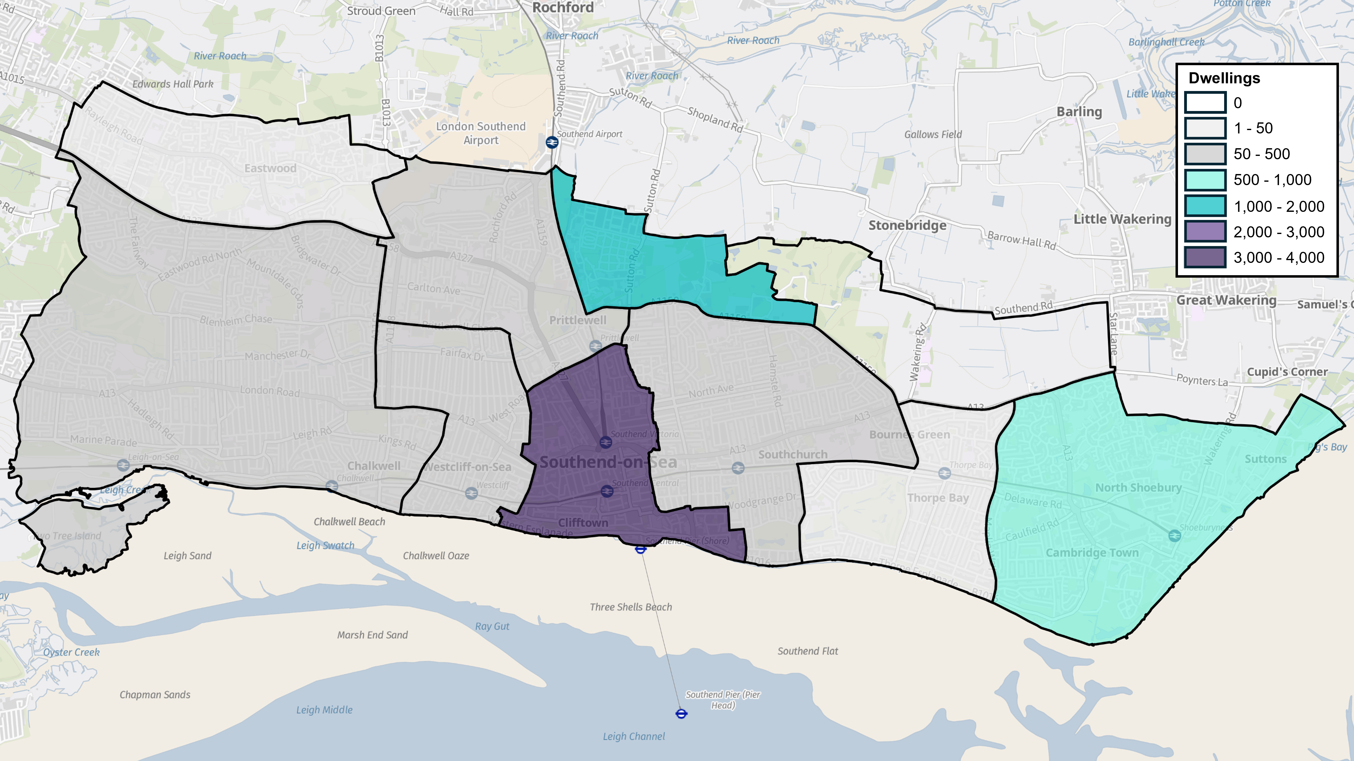
Plus 2,400 new homes from windfall development
Why we have taken this approach
5.3 Over many years Southend has continued to grow leading to pressure on its social and physical infrastructure and is also suffering from a worsening housing crisis, with higher rates of overcrowding, enforced house sharing and homelessness compared to the national average. House prices and private rents continue to outstrip local wage levels, and it is very hard for young people to get on the housing ladder.
5.4 The Local Plan seeks to provide people with a choice of decent, well-designed housing to meet their needs at a cost they can afford. There is a need to plan for an annual increase in housing and to identify the location of new homes and provide for a variety or mix of homes in terms of type, size and tenure (the type of new homes). It is important that new development is accompanied by supporting infrastructure, meets a range of local housing needs and contributes to the creation of mixed and sustainable communities by respecting local distinctiveness and protecting the built, natural and historic environment.
The Delivery of New Homes
5.5 It is vital that growth in Southend is 'infrastructure led'. This means that the provision of new homes is supported by improvements in the quality of services, transportation, and facilities for the future health, education, sports and leisure and community needs of residents. (Strategic Policy SP3 sets out the approach to securing and improving infrastructure).
5.6 In seeking to meet future housing needs and creating balanced and sustainable communities in the face of limited land resources, it will be essential that not only is optimum use made of available sites but that these are developed to a high standard and quality of design to ensure the successful integration of the scheme within the area and that the character and amenities of existing residential areas are protected in accordance with the provisions of Chapter 8 of this Plan (Urban Design, Character and Built Heritage). It will also be important to ensure that a wide choice of homes is delivered providing for a range and mix of housing to meet future identified needs.
National Planning Policy
5.7 In line with national planning policy establishing a housing requirement through the adoption of a Local Plan can be summarised as a 2-stage process as follows:
- Requires housing needs to be objectively assessed (often termed a policy-off approach) – in line with the national Standard Methodology; and
- Then a distinct assessment made as to whether (and, if so, to what extent) other policies dictate or justify constraint (policy-on approach).
5.8 It is through this two-stage process, that housing provision is refined, tested and consulted upon through the preparation of Local Plans. Local Authorities are then able to establish a housing requirement figure for their whole area, which shows the extent to which their identified housing need can be met over the plan period.
5.9 In practice landowners and developers (including the Council itself) promote land for development. This is then tested and consulted upon as part of the Local Plan preparation process to determine if such sites can be delivered during the plan period and result in sustainable development.
Local Plan Preferred Approach – meeting housing needs
5.10 The Local Plan makes provisions for at least 9,500 homes (4,000 through existing permissions, 1,900 site allocations, 1,200 opportunity sites and a windfall allowance of 2,400) that could be sustainably accommodated within the existing urban area of Southend, including land at Fossetts Farm to the north of the city by 2040.
5.11 The Local Plan preparation process has highlighted that there is not enough land to meet housing need as defined by the national standard methodology, despite multiple call for sites (allocations), identifying broad locations for development (opportunity sites), applying a range of density assumptions based on typologies and making an allowance for unidentified development based on past rates (windfall).
5.12 The Local Plan housing provision results in a short fall of approximately 14,400 new homes by 2040 compared to the national Standard Method for calculating need (which suggest 1,405 new homes are needed per annum). The possible policy option of developing Green Belt land north of Southend as identified in Chapter 3b (Question on whether to develop a new neighbourhood on land to the north of Southend) could potentially accommodate a further 4,000 to 5,000 dwellings within Southend but would still be nearly 10,000 homes short of the Governments Standard Housing Method for Southend to 2040.
5.13 The Council will continue to work closely with neighbouring authorities to explore opportunities in resolving infrastructure and environmental constraints to determine if unmet need arising in Southend can be met elsewhere.
Appendix 2 provides more information on the sources of supply in delivering new homes and lists all potential allocations and opportunity sites.
The type of new homes
5.14 Housing market data and recent demographics highlight the difficulties faced by a large portion of the resident population in securing housing that is affordable. With rising house prices and interest rates, and large deposits required, owner occupied housing is increasingly becoming beyond the financial means of a significant number of local residents. This trend is reflected in a significant growth in the private rented sector. However, the private rental sector has also witnessed increasing rental values which have exacerbated the affordability issue.
5.15 Privately rented households are likely to increase in number in Southend given projected growth in this type of housing – such as unrelated sharing adults and families. This demand could be predominantly met through stock managed by private landlords but Build to Rent schemes may also become more prominent in the city.
5.16 In addition to affordability, the city's older populationOver 65 years of age is increasing and grew by 12% in the ten years between 2011 to 2021Census (ONS), generating a requirement for specialist housing to meet their specific needs. The number of families with children is also increasing creating a demand for family dwellinghouses with the population of younger age groups in Southend under the age of 15 growing 4.2% over the same period. The student population in Southend has been stable in recent years (South Essex Housing Need Assessment HNA 2022).
5.17 The provision of housing also impacts on people's health and wellbeing which need to be addressed in all development schemes. This includes internal space, accessibility and adaptability, outdoor amenity space, and suitably adapted homes to support independence at home.
5.18 Future development should therefore seek to provide for a diverse range and mix of housing products within the local housing market including the affordable sectors. This is necessary to meet the housing needs of the city, including units suitable for families, older people, students and people wishing to build their own homes and Starter Homes.
5.19 In seeking to meet this provision, it is essential that the existing residential stock is safeguarded and planning applications that result in the loss of residential accommodation will not normally be permitted, particularly small family dwellinghouses providing accommodation for families with children.
Gypsies and Travellers
5.20 Gypsies and Travellers have their own specific housing requirements. The South Essex Gypsy and Traveller Area Assessment Update 2019South Essex Gypsy and Traveller Area Assessment Update, 2019 does not identify any need for permanent pitches within the city. This is reiterated in the more recently completed assessment undertaken specifically for the Southend area with no identified need over the plan period.Southend-on-Sea City Council Gypsy and Traveller Accommodation Assessment (GTAA), December 2024
5.21 However, while there is no current identified need for Gypsy and Traveller sites in the city, Policy SP5 sets out a criteria-based framework should any established need be identified and an application be received for such facilities. This accords with national guidancePlanning Practice Guidance (PPG), Planning Policy for Traveller Sites, Ministry of Housing, Communities and Local Government, December 2024 (Paragraph 11).
Have your say…
Please explain your answers
QSP5: Do you agree with draft Strategic Policy SP5: Homes? Please explain your answer.
Affordable Housing – development management policy
Strategy and Objectives Linkage
Strategic Objective 2
Strategic Objective 3
Strategic Objective 9
Strategic Policy SP6
Why we need this Policy
5.20 House prices in Southend have risen considerably over the past 20 years partly fuelled by strong house price growth in London and as a result of a limited housing supply in reference to the size of the population. This combined with the requirement for purchasers to have an initial deposit has created an increasingly significant barrier for people wishing to purchase their own home. Many of these households have turned to alternative housing products with smaller immediate financial requirements, thereby delaying their buying of a home.
5.21 The private rented sector has seen considerable growth as a result with the cost of privately renting any size of property rising most notably for properties with three bedrooms. However, despite increasing rental levels, Southend has the lowest rents, both overall and for each size of property, in South EssexONS (2021) Private Rental Market Statistics.
5.22 In Southend the percentage of private renting increased from 22.0% in 2011 to 26.5% in 2021 whilst the rate of social renting remained constant at 11.5% and the rate of home ownership decreased from 65.2% to 61.3%.
5.23 As a result of these circumstances many people in Southend who want to own their own homes simply cannot afford to do so. In addition, over a third of newly arising households are now unable to afford a lower quartile private sector rented property without spending over a third of their income on rent.
5.24 The National Planning Policy Framework (NPPF) requires local authorities to assess the number of affordable homes that are evidenced as being required in their area. Affordable housing is defined as:
"housing for sale or rent, for those whose needs are not met by the market (including housing that provides a subsidised route to home ownership and/or is for essential local workers); and which complies with one or more of the following definitions: Social Rent, Other affordable housing for rent, discounted market sales housing, Other affordable routes to home ownershipNational Planning Policy Framework 2024, Annex 2 Glossary (further detail on each of the affordable housing types provided in this glossary)."
5.25 National Planning Policy provides that affordable housing should not be sought for residential developments that are not major developments (less than 10 units) and on major development sites planning policies and decisions should expect that the mix of affordable housing required meets identified local needs, across Social Rent, and other affordable housing for rent and affordable home ownership tenuresNational Planning Policy Framework 2024 – paragraphs 65 and 66..
5.26 The planning guidance establishes a methodologyPPG Section 67 – "Housing needs of different groups"; relevant paragraphs last revised in July 2019. At the time of writing, Section 2 of the PPG ("Housing and economic needs assessment") retains almost identical guidance on assessing affordable housing needs, which was last revised in February 2019. for assessing affordable housing need which takes into account households on the Council's housing registers, newly arising households in need as a result of changing circumstances (for example when their financial or family circumstances change) and the available supply of affordable housing taking into account lettings, the release of occupied affordable homes and committed supply. This results in a significant need for affordable housing well above recent delivery
5.27 Policy SP6: Homes establishes that due to the limited availability of land it is not possible for Southend to meet the Government's objectively assessed standard method in full. Nevertheless, the methodology for assessing affordable housing need highlights the significant demand for affordable housing in Southend and the need to make optimum use of land and property resources in seeking to maximise the opportunities for achieving affordable housing provision whilst recognising the viability constraints to achieving this in terms of land purchase, development and other related costs.
5.28 The assessment of affordable housing need when broken down by the size of property required suggests that in Southend there is a shortfall of every size of property, which is most pronounced for homes with two bedrooms.
5.29 In seeking to meet the need for affordable housing, the Council has applied an affordable housing policy since 2007 as contained in its Core Strategy. This sought to ensure that in residential developments of 10-49 dwellings (or 0.3 hectares up to 1.99 hectares) not less than 20% of the total number of units were affordable, whilst for residential proposals of 50 dwellings (or 2 hectares) or more, not less than 30% of the total number of units on the site were affordable.
5.30 The NPPF requires Local Plans to be informed by viability assessments based on market evidence. This is to ensure planning policies are set at a level so as not to place an unreasonable burden on development so it can be demonstrated that growth set out in the local plan is broadly deliverable over the plan period. The plan should not expect every site to be 'deliverable' now, within the current market, but with a realistic prospect of sites coming forward at a later date.
5.31 Initial viability assessment suggests that the provision of affordable housing will have an impact on the development viability. The viability assessment highlights areas within Southend having stronger and weaker viability linked to sale values achieved in different areas across the city. For instance, Leigh, Thorpe Bay and areas around Shoebury Garrison and the Central Seafront have the highest sale values in the city. Viability assessment outlines that these areas can support the Core Strategy affordable housing rate of 30%. Outside of these areas assessment suggests that viability is more marginal for flatted development on brownfield due to the higher associated build costs (relative to the provision of houses and greenfield sites). Therefore, an affordable rate of 10% is recommended for brownfield flatted development in mid/ low viability areas.
How the Policy Works
5.32 The policy provisions are based on current and future demographic and market trends which indicate a significant need for affordable housing provision in Southend to meet the locally generated needs to 2040.
5.33 The Policy presents two options regarding the rate of affordable housing to be applied to new major development schemes. A continuation of the current provisions as set out in the adopted Core Strategy (20% affordable housing provision on sites of 10 to 49 dwellings and 30% on larger sites) or a new rate reflecting the viability across different parts of the city which demonstrates 30% affordable housing for 10 units or mote, except where flatted development is delivered on land classified as brownfield outside the high value areas of Leigh, Thorpe Bay, Shoebury Garrison and the Central Seafront, where a rate of 10% would apply. Such provision aims to strike an appropriate balance between seeking a realistic proportion of a major development site to consist of affordable housing having regard to the significant demand for such housing, whilst recognising development viability considerations.
5.34 Policy Table DM5.1 reflects the findings of the Housing Need Assessment (2022) and is intended to provide an overall target for new residential development within the city. For individual development proposals the preferred dwelling mix should not be treated as a definitive mix but should be used during negotiations. When considering development proposals that deviate from this mix, the Council will take account of the latest available evidence from the HNA (or its equivalent successor); the site context; viability and any pressing short-term housing need as identified by Southend Council's Homeseekers Register.
Policy Table DM5.1: Estimated Annual Net Need For and Size of Affordable Housing in South Essex (2021 to 2040)
|
||||||||||||||
Source: Turley Analysis 2022
Policy DM5.1: Affordable Housing
- All residential or mix-use proposals, including build to rent accommodation, that include an element of residential will be required to make provision of affordable housing as follows:
Option 1 – continuation of existing rates (Core Strategy)
- Schemes of 10 – 49 dwellings will make an affordable housing or key worker provision of not less than 20% of the total number of units on site;
- Schemes of 50 dwellings or more will make an affordable housing or key worker provision of not less than 30% of the total number of units on site.
Option 2 – rate adjusted to reflect viability
- Schemes of 10 dwellings or more will make an affordable housing or key worker provision of not less than 30% of the total number of units on site, excluding brownfield flatted development outside high value areas (Leigh, Thorpe Bay, Shoebury Garrison, Central Seafront) where an affordable housing or key worker provision of not less than 10% of the total number of units on site will be applied.
- Affordable housing provision will normally be met on-site, unless off-site provision or an appropriate financial contribution in lieu can be robustly justified to the Council and is equivalent to the cost of on-site provision*.
- In exceptional circumstances where there is evidence that a development is unviable at the affordable housing requirements set out in this policy, it will be the responsibility of the applicant to make the case to the satisfaction of the Council**.
- Affordable housing provision should incorporate a mix of size and tenures on the following basis:
- the Council will seek no less than between 80% of all new affordable housing to be affordable housing for rent, with the remainder affordable home ownership products, as defined in the NPPF. The Council will seek nomination rights in the Section 106 Agreement***.
- proposals for new affordable accommodation will be required to provide a mix of different sized accommodation, having regard to the most recent Housing Needs Assessment outputs (currently set out in Policy Table DM5.1).
- on individual sites, the preferred affordable housing mix (in terms of unit size and type of dwelling) should be provided in a range of sizes and types across the affordable housing tenures, informed by the latest assessments of local housing needs, the Council's Homeseekers register, and site context/ neighbourhood characteristics and viability amongst other things.
* Off-site provision should be used in exceptional circumstances and only where there is detailed evidence submitted to demonstrate that on-site affordable housing delivery is not practical, or where an off-site contribution would better deliver mixed and inclusive communities. Cash in lieu contributions should be used in even more limited circumstances, and only where there is detailed evidence submitted demonstrating that on-site delivery is not practical, off-site provisions have been explored but are not deliverable, and that accepting a cash in lieu contribution will not be detrimental to the delivery of mixed and inclusive communities. Further details can be found in Appendix 7.
** Where this can be demonstrated to the satisfaction of the Council, the agreement will include Viability Review Mechanisms to ensure that affordable housing delivery is maximised as a result of any future improvement in viability. Further details are provided in Appendix 7.
*** Nomination agreements for affordable rented to be 80% of market or Local Housing Allowance rates, whichever is lowest, inclusive of service charge
Have your say…
Please explain your answers
Q5.1.1: Do you agree with Development Policy DM5.1: Affordable Housing?
Q5.1.2: What rate of affordable housing should be applied to new major development proposals (see DM5.1.1)
Option 1 - continuation of existing rates (Core Strategy)
Option 2 - rate adjusted to reflect viability
Mix and Quality of Homes – development management policy
Strategy and Objectives Linkage
Strategic Objective 2
Strategic Objective 9
Strategic Policy SP6
Why we need this Policy (justification)
5.35 The delivery of a wide choice of homes will be essential to ensure that all development schemes contribute to the creation of mixed, balanced, inclusive and sustainable communities that meet the housing needs of the city. Updated housing assessments of need indicate that in Southend;
- there will be a substantial growth in the number of households with children;
- there would likely be almost as much growth in the number of one-person households, with this group a particularly key driver in Southend;
- a continuation of these local trends could see some 35% of additional households in Southend needing three bedrooms; about 30% could need two bedrooms and just over half as many (19%) could need one bedroom, with the remaining 16% needing at least four bedrooms;
- over the last 20 years the overwhelming proportion of dwellings have been 1 and 2 bed (78%) and there is need for more family accommodation.
5.36 Policy SP6: Homes establishes that due to the limited availability of developable land it is not possible for Southend to meet the Government's objectively assessed standard method in full. As the Housing Need Assessment (2022) is based on Southend meeting its objectively assessed housing needs in full the findings have to be treated with a degree of caution, but they do nevertheless provide a proportionate guide to the size and type of housing mix that is required in the city as indicated in Policy Table DM5.2.
How the Policy Works
5.37 The policy provisions are based on current and future demographic trends, market trends and the differing needs of various sectors of the community to ensure the delivery of a mix, size and type of homes to meet local needs.
5.38 Policy Table DM5.2 reflects the findings of the Housing Need Assessment (2022) and is intended to provide an overall target for new residential development within the city. For individual development proposals the preferred dwelling mix should not be treated as a definitive mix but should be used during negotiations. When considering development proposals that deviate from this mix, the Council will take account of the latest available evidence from the SHMA (or its equivalent successor); the site context; and viability.
5.39 It will be important to ensure that any development scheme is compatible with and complements its locality in terms of its massing and design and optimises the development potential of the site. In this respect, a number of development sites (Allocations and Opportunity Sites) and areas identified for regeneration and growth that are highly accessible offer the potential to achieve higher density flatted development where compatible with local character. In contrast more suburban areas provide the potential to achieve a larger proportion of family housing.
Policy Table DM5.2: Preferred Private Market Dwelling Mix
|
||||||||||||||
Policy DM5.2: Mix and Quality of Homes
- The Council will promote the delivery of a wide choice of homes which will contribute to the creation of mixed, balanced, inclusive and sustainable communities that incorporates a range of dwelling types and bedroom sizes, including family housing, to reflect the city's housing need and housing demand.
- Proposals for 10 or more dwellings will be required to provide a mix of different sized and types of homes, having regard to the most recent Housing Needs Assessment outputs, as set out in Policy Table DM5.2. Where a proposal significantly deviates from this mix the reasons must be justified and demonstrated to the Council.
- In considering an appropriate mix of homes the Council will also take into consideration the location, size and characteristics of the site, for instance:
- proposals that come forward within highly accessible locations, which comprise high density flatted development may include a higher proportion of smaller units, but should still include an element of family sized accommodation;
- whilst more suburban areas should provide for a larger proportion of family sized housing than the preferred mix set out in Policy Table DM5.2.
Have your say…
Please explain your answers
Q5.2: Do you agree with draft Development Management Policy DM5.2 Mix and Quality of Homes? Please explain your answer.
Safeguarding Existing Housing Stock – development management policy
Strategy and Objectives Linkage
Strategic Objective 2
Strategic Objective 9
Strategic Objective 13
Strategic Policy SP6
Why we need this Policy (justification)
5.40 With its high urban densities and limited land resources, opportunities for increasing the housing supply in the city are severely constrained. In such circumstances it is essential to ensure that the city's valuable existing housing stock is retained and safeguarded.
5.41 The Policy aims to safeguard the existing housing stock from inappropriate development to ensure that it continues to make a valuable contribution to meeting local housing needs.
How the Policy Works
5.42 The Local Plan seeks to resist development proposals that result in the net loss of residential accommodation except in certain circumstances, including the need to meet residential standards within Policy DM5.5. Other exceptions apply where a net gain of affordable housing can be achieved or where a loss would be the only way to preserve a building of special architectural or historic interest. All exceptions will need to be clearly justified and accompanied by suitable supporting information.
5.43 Where development involves the demolition and redevelopment of homes, the Council will generally expect proposals to provide an equivalent or greater number of replacement homes. Where an application involves a small-scale net loss of Use Class C3 residential units (for example the de-conversion of small flats back to a family sized home) then applications will be considered on their merits taking account of other considerations including, for example, amenity considerations and evidence regarding the city's identified housing needs.
5.44 The objectively assessed housing need indicates that there will be a demand for family sized homes (3+ bedroom properties) and the de-conversion of small flats back to family sized homes can contribute towards this element of identified need.
5.45 A change of use may be permitted where a local need can be demonstrated to provide an important local community facility (see Policy DM4.1).
Policy DM5.3: Safeguarding Existing Housing Stock
- The Council will resist any net loss of existing residential accommodation (Use Class C3) in the city. Planning applications that result in the loss of residential accommodation will not be permitted unless one or more of the following exceptions apply:
- the proposed change of use will provide a local community service/ facility, including health and social care provision, that meets an identified need;
- it can be demonstrated that the amount of accommodation cannot be rehabilitated or redeveloped to achieve satisfactory residential standards as set out in Policy DM5.5 Residential Standards;
- the proposal would result in a net gain in units of affordable housing;
- the loss would enable sub-standard residential units to be enlarged to meet residential space standards (in accordance with Policy DM5.5 Residential Standards);
- it can be demonstrated that a proposed change of use is the only practicable way of preserving the special architectural or historic interest of a listed building or other designated heritage asset; or
- where the previous use of the building would be a material consideration.
- Proposals for the de-conversion/ amalgamation of Use Class C3 residential units involving a net loss that deliver family sized accommodation will be supported in principle.
Have your say…
Please explain your answers
Q5.3: Do you agree with draft Development Management Policy DM5.3 Safeguarding Existing Housing Stock? Please explain your answer.
Residential Conversions and the Retention of Family Housing– development management policy
Strategy and Objectives Linkage
Strategic Objective 2
Strategic Objective 9
Strategic Objective 13
Strategic Policy SP6
Why we need this Policy (justification)
5.46 The aim of this policy is to manage the subdivision of single residential units into smaller self-contained units in order to ensure that conversions provide a high standard of accommodation and promote and retain housing choice in the city to meet local needs.
5.47 Southend has a large demand for 2 and 3 bed family housing and it is important that the existing stock is retained to provide a valuable resource to meet the needs of families and provide housing choice. In contrast, the conversion of larger properties into smaller residential units plays an important role in increasing housing supply, contributes toward the provision of a wider range of housing, and helps to meet the needs of a growing number of smaller households. It is also consistent with the objective of making the best use of the land available within the city.
How the Policy Works
5.48 The Policy aims to control the conversion of housing to smaller units in the interests of protecting the character and amenities of residential areas and retain family sized accommodation. The policy therefore seeks to strike a balance between protecting smaller family dwellinghouses from conversion whilst allowing the suitable conversion of larger properties into smaller units. The policy safeguards those single family dwellinghouses with an original floor area that is less than 124sqm and to ensure that the sub-division of larger residential units (with a floor area greater than 124sqm) will provide for at least one unit suitable for family occupation (a minimum of 3 bedrooms).
5.49 A high proportion of house to flat conversions can have an adverse impact on residential amenity, particularly in those areas where dwelling densities are already high. The conversion of properties below the threshold stated in the policy would result in a poor standard of accommodation and as such the policy is consistent with the aims of the Nationally Described Space Standards (see Policy DM5.5 Residential Standards). Similarly, too many conversions can exacerbate on-street parking stress to the detriment of the local street scene, particularly in the older Edwardian and Victorian streets of the city with limited off-street parking facilities.
Policy DM5.4: Residential conversions and retention of family housing
- Planning permission for the conversion of dwellings into smaller units of self-contained accommodation will be granted only where all the following criteria are met:
- the floor area¹ is equal or greater than 124sqm or the existing dwelling has 4 or more bedrooms; At least one unit of the accommodation to be provided is suitable for family occupation and has a minimum of three bedrooms²;
- the proposal provides a high standard of accommodation that complies with requirements set out in Policy DM5.5 Residential Standards;
- does not adversely impact upon the living conditions and amenity of the intended occupants and neighbouring residents and uses;
- will not harm the character and appearance of the existing building or wider area;
- will not lead to a detrimental change of a street's function; and
- the vehicle parking standards set out in Policy DM10.3 are met.
- The requirement within criterion DM5.4.1ii. for a unit of family accommodation will not apply where it is demonstrated that:
- a different mix of units is essential to preserve the character of a listed building; or
- a different mix of units is necessary to meet the needs of existing occupants who will remain on completion of the conversion; or
- the proposal is specifically for people with special housing needs.
1 The calculation of the floor area must be based on internal dimensions only and exclude garages and conservatories.
2 i.e. a 3-bedroom, 4-person unit (74sqm) or larger
Have your say…
Please explain your answers
Q5.4: Do you agree with draft Development Management Policy DM5.4 Residential conversions and retention of family housing? Please explain your answer.
Residential Standards – development management policy
Reference to Strategic Objective and Strategic Policies
Strategic Objective 2
Strategic Objective 9
Strategic Objective 13
Strategic Policy SP6
Why we need this Policy (justification)
5.50 Housing design and quality is not only important aesthetically in terms of its visual impact on the local environment and street scene, it also has a direct impact on who can live there and on the health and well-being of occupiers in terms of the internal space available, its accessibility and adaptability, and suitability to support independent living at home.
5.51 The value of internal space and layout in achieving the delivery of quality homes within the city has long been recognised by the Council. It is the Council's aim to deliver good quality housing, ensuring that new developments contribute to a suitable and sustainable living environment now and for future generations. To achieve this, it is necessary to ensure that new housing developments provide the highest quality internal environment that will contribute to a good quality of life and meet the requirements of all the city's residents.
5.52 National planning guidance recognises that 'accessible and adaptable housing enables people to live more independently, while also saving on health and social costs in the future'PPG Reference ID 63-008-20190626. It further suggests that:
"It is better to build accessible housing from the outset rather than have to make adaptations at a later stage – both in terms of cost and with regard to people being able to remain safe and independent in their homes"
5.53 This is vitally important given that nearly 20% of Southend residents have their day-to-day activities limited a lot or a little due to long-term health problems and/or disability (with 8% limited a lot). The majority of these (approximately 90%) do not live in communal establishments but mainly live at home independently or with relatives, friends or carersONS Census 2021.
How the Policy Works
5.54 The Council will apply the Governments nationally described space standard set out in its published guidance 'Technical Housing Standards'Statutory Guidance – Technical Housing Standards – March 2015 and will expect all forms of residential accommodation to have regard to these standards including those not considered to fall within Use Class C3. Such accommodation can include Houses in Multiple Occupation (HMOs), extra care, assisted living and other such schemes designed for frailer older people or others with disabilities and those in need of care or support. In respect of a property being extended, the new extension will be expected to accord with the relevant standards, and it must not make the existing accommodation worse.
5.55 It is recognised that there may be some instances when an exception to an element of the requirements might be justified. For example, it may not be viable to provide level access via a lift to all units within small residential schemes. In such instances the accessible and adaptable standard should be met as far as possible applying where practicable an alternative solution to lift provision, such as an accessible stairway capable of providing a stair lift. A flexible approach to the standards might also be justified with regard to a conversion of a listed building. Where it is considered full compliance with the standards would not be possible, applicants must address this at an early stage in the planning and design process.
5.56 The needs of wheelchair users are often difficult to meet in general needs housing and invariably require increased circulation and activity spaces within and between rooms, particularly in bathrooms and kitchens. In recognition of this, the Council will require at least 10% of new housing in all major developmentsMajor developments are those of 10 or more residential units. to be wheelchair accessible, or easily adaptable for a wheelchair user in accordance with the Equality and Human Rights Commission recommendation that at least 10% of new-build housing across all tenure types should be built to higher wheelchair-accessible standardsEquality and Human Rights Commission (2018) Housing and disabled people: Britain's hidden crisis M4(3) design standard. The 10% wheelchair requirement will be accommodated within developments by varying unit sizes to accommodate the additional floorspace required for turning circles.
5.57 Lack of storage space can be a particular problem in many new homes. Without adequate storage space, resident's belongings will often take space away from the living accommodation and have an adverse impact on amenity. The lack of storage space within a home may, therefore, have a restrictive effect upon the way a home is used. There is, therefore, a need to ensure that dwellings contain sufficient space both internally and externally (where applicable).
5.58 Private outdoor space is an important amenity asset and provides adults and children with external, secure recreational areas. Private amenity space can make an important contribution in improving the health, well-being and general quality of life of the city’s residents. It also has the potential to support and enhance local biodiversity and can contribute to existing ecological and green infrastructure networks. This space must be useable and functional to cater for the needs of the intended occupants such as providing space for seating, play, drying and storage space. All new residential units will be expected to have direct access to an area of private amenity space. The type of amenity space will be dependent on the location and context of residential development. Factors such as the type, scale, orientation, scope for privacy, size and usability will all be important. In the case of non-flatted developments, generally this can most easily be provided in the form of a private enclosed garden. The provision of a garden also makes it easier to include outside covered storage for items such as bicycles and garden furniture. In the case of flats, balconies may take the place of a garden, although easily accessible semi-private communal areas will also be beneficial.
Policy DM5.5 Residential Standards
- Planning applications for new residential development (including residential extensions and residential accommodation falling outside Use Class C3) must comply with the following requirements:
- all residential units should meet or exceed the nationally described space standards1 (Policy Table DM5.5);
- all residential units should as a minimum be accessible and adaptable in accordance with Building Regulation M4(2)2;
- for proposals providing 10 or more dwellings, 10% of the residential units should be suitable for occupation by a wheelchair user in accordance with Building Regulation M4(3)3 and be evenly spread across both private and affordable tenure. Where the Council is responsible for allocating or nominating the occupier, these homes should be 'wheelchair accessible' and preferably with ground floor access at the point of completion, whilst in other cases they may be 'wheelchair adaptable'. Where this is not practicable on-site an equivalent financial contribution must be provided4; and
- make provision for usable private outdoor amenity space for the enjoyment of intended occupiers; for flatted schemes this could take the form of a balcony or easily accessible semi-private communal amenity space. Residential schemes with no amenity space will only be considered acceptable in exceptional circumstances, the reasons for which will need to be fully justified and clearly demonstrated;
Exceptions to the above criteria will only be permitted where the applicant has provided a robust justification, and the Council is satisfied that particular circumstances apply.
- All proposals for non self-contained accommodation (such as student, hospital staff, some forms of older people accommodation) must as a minimum meet the nationally described space standards as set out in Policy Table DM5.5, with particular reference to room size set out in the technical requirements.
1 The nationally described space standards as set out in the policy or as amended. Residential accommodation that does not fall within a C3 use class (e.g. extra care accommodation, assisted living housing and Housing in Multiple Occupation) and residential extensions will be expected to meet the standards where relevant. As a minimum such accommodation should meet the standards for bedroom sizes, storage, ceiling heights and provision of level access.
2 Building Regulations M4(2) or as amended.
3 Building Regulations M4(3) or as amended.
Policy Table DM5.5: Nationally Described Space Standards
Minimum gross internal floor area and storage (sqm)
|
Number of bedrooms (b) |
Number of bed spaces (persons) |
1 storey dwellings |
2 storey dwellings |
3 storey dwellings |
Built-in storage |
|
1b |
1p |
39 (37) * |
1.0 |
||
|
2p |
50 |
58 |
1.5 |
||
|
2b |
3p |
61 |
70 |
2.0 |
|
|
4p |
70 |
79 |
|||
|
3b |
4p |
74 |
84 |
90 |
2.5 |
|
5p |
86 |
93 |
99 |
||
|
6p |
95 |
102 |
108 |
||
|
4b |
5p |
90 |
97 |
103 |
3.5 |
|
6p |
99 |
106 |
112 |
||
|
7p |
108 |
115 |
121 |
||
|
8p |
117 |
124 |
130 |
||
|
5b |
6p |
103 |
110 |
116 |
3.5 |
|
7p |
112 |
119 |
125 |
||
|
8p |
121 |
128 |
134 |
||
|
6b |
7p |
116 |
123 |
129 |
4.0 |
|
8p |
125 |
132 |
138 |
Technical Requirements:
- the residential unit provides at least the gross internal floor area and built-in storage area set out in Policy Table DM5.5.
- a residential unit with two or more bedspaces has at least one double (or twin) bedroom.
- in order to provide one bedspace, a single bedroom has a floor area of at least 7.5sqm and is at least 2.15m wide.
- in order to provide two bedspaces, a double (or twin bedroom) has a floor area of at least 11.5sqm.
- one double (or twin bedroom) is at least 2.75m wide and every other double (or twin) bedroom is at least 2.55m wide
- any area with a headroom of less than 1.5m is not counted within the Gross Internal Area unless used solely for storage (if the area under the stairs is to be used for storage, assume a general floor area of 1sqm within the Gross Internal Area)
- any other area that is used solely for storage and has a headroom of 900-1500mm (such as under eaves) is counted at 50% of its floor area, and any area lower than 900mm is not counted at all
- a built-in wardrobe counts towards the Gross Internal Area and bedroom floor area requirements but should not reduce the effective width of the room below the minimum widths set out above. The built-in area in excess of 0.72sqm in a double bedroom and 0.36sqm in a single bedroom counts towards the built-in storage requirement
- the minimum floor to ceiling height is 2.3m for at least 75% of the Gross Internal Area
Notes (added 19 May 2016):
- Built-in storage areas are included within the overall GIAs and include an allowance of 0.5sqm for fixed services or equipment such as a hot water cylinder, boiler or heat exchanger.
- GIAs for one storey dwellings include enough space for one bathroom and one additional WC (or shower room) in dwellings with 5 or more bedspaces. GIAs for two and three storey dwellings include enough space for one bathroom and one additional WC (or shower room). Additional sanitary facilities may be included without increasing the GIA provided that all aspects of the space standard have been met.
- Where a 1b1p has a shower room instead of a bathroom, the floor area may be reduced from 39sqm to 37sqm as shown bracketed.
- Furnished layouts are not required to demonstrate compliance.
Have your say…
Please explain your answers
Q5.5: Do you agree with draft Development Management Policy DM5.5 Residential Standards? Please explain your answer.
Houses in Multiple Occupation – development management policy
Reference to Strategic Objective and Strategic Policies
Strategic Objective 2
Strategic Objective 3
Strategic Objective 9
Strategic Objective 13
Strategic Policy SP6
Why we need this Policy (justification)
5.59 Houses in Multiple Occupation (HMOs) and other shared housing form part of the city's private rented housing stock and make a contribution to people's housing choice. With significant rises in the cost of housing over the past 20 years a growing number of people in Southend have turned to more affordable shared housing, including Houses in Multiple Occupation.
5.60 However, multiple occupancy has the potential to create negative impacts on the residential amenity and character of an area as a result of more frequent noise nuisance and disturbance, increased pressure on parking due to higher population densities, and higher levels of population transience leading to a possible longer-term breakdown of community cohesion.
5.61 As such HMOs are likely to have proportionately greater impacts on surrounding occupants and neighbourhoods as each additional resident will increase the level of activity through more frequent comings and goings, different patterns of behaviour and consequential noise and disturbance. A property occupied by a group of unconnected adults is likely to have a greater impact than a typical family home with a similar number of occupants as lifestyles and movement patterns will be less connected.
5.62 A House in Multiple Occupation is defined as a property rented to at least three people who are not from one 'household' (e.g. a family) but share facilities such as a bathroom and kitchen. Examples include bedsits, shared houses and lodgings. The planning Use Classes Order distinguishes between 'small' HMOs of up to six people (Use Class C4), and 'large' HMOs of seven of or more occupants which are sui generis. The General Permitted Development Order (GPDO) provides permitted development rights to convert ordinary family housing (Use Class C3)to small Class C4 HMO use without the need for planning approval. Larger sui generis HMOs on the other hand will always require planning approval to be created from either Class C3 housing or any other land use. To bring all HMOs under planning control it is proposed to introduce an Article 4 Direction in the city removing permitted development rights.
5.63 There are approximately 2,320 HMO bedspaces spread across the city. These are principally concentrated in Edwardian and Victorian housing in the central parts of the city in the Westcliff, Southend Central and Southchurch neighbourhoods. Of the remaining HMOs the majority are located in the southern part of the Leigh neighbourhood. All these areas are characterised by tightly knit housing with limited off-street parking spaces, located near to city and district centres and transport hubs.
5.64 With growing numbers of people turning to HMOs as a source of affordable housing, the HMO policy seeks to ensure that an appropriate balance is struck between meeting the demand for this form of housing whilst protecting and safeguarding the character and amenities of established residential areas. The policy also seeks to provide good quality accommodation by ensuring development complies with relevant standards and requirements.
5.65 In addition, the HMO policy recognises the need to safeguard an adequate stock of small family dwellinghouses to meet the demands for family housing in the city in accordance with the provisions of Policy DM6.4 and permits the reversion of HMO properties to family homes.
How the Policy Works
5.66 This policy applies to building new HMOs; converting existing dwellings into HMOs; intensifying existing HMOs through an increase in the number of bedspaces, where this requires planning permission; and other forms of shared housing.
5.67 Policy DM5.6 (Houses in Multiple Occupation) responds to the demand for lower cost housing accommodation by allowing for further conversion to HMOs but only where this does not harm residential amenities and the character of an area or where the choice of housing is reduced and no longer provides for the different groups within the community through concentrations of HMOs. The Council considers that a harmful concentration is likely to arise when more than 10% of the total dwelling stock is occupied as HMOs within 50 metres of the site. Harm can also be localised when an existing dwelling is sandwiched between two HMOs intensifying impacts on individual households or where it results in a continuous frontage of three or more HMOs.
5.68 To ensure a good standard of accommodation for future occupiers, issues relating to internal living space, layout, external amenity space, outlook, privacy, adaptability, security, safety, cycle and car parking and refuse and recycling storage will need to be considered.
5.69 The Housing Act 2004 requires landlords of larger HMOs to apply for licences which is a separate regulatory regime to planning and seeks to secure minimum standards of accommodation fit for human habitation such as fire safety standards and access to basic facilities such as a kitchen, bathroom and toilet facilities. Regulatory standards also apply to smaller HMOs. The planning system has a wider responsibility for ensuring that the quality of accommodation will provide more than the bare minimum for its occupants by ensuring an adequate standard of living for long term occupants.
5.70 Where additional bedrooms are created in both new build HMOs and conversions of existing buildings, these will be expected to meet the internal space standards set out in Policy DM5.5. Appropriately sized, proportioned and equipped communal areas and adequate bathroom and cooking facilities should be provided, relative to the expected number of occupants in accordance with the Council's adopted guidance.
5.71 Communal living space should be provided within the main structure of the building and not within conservatories due to the inferior noise insulation and consequent effect on amenity of neighbours. Insufficient communal areas increase the time occupants must spend in their individual bedrooms and can therefore hinder social cohesion within the property.
5.72 Planning applications must be supported by a full set of floor plans that includes details showing the internal measurements for each room; for bedrooms indicating if they are intended to be single or double; and any areas of reduced ceiling heights.
5.73 HMO proposals are also required to provide useable private outdoor amenity space appropriate to the scale and character of the development as required by Policy DM5.5: Residential Standards.
Policy DM5.6: Houses in Multiple Occupation
- Planning permission will be granted for the conversion of sui generis Houses in Multiple Occupation to self-contained family homes (Use Class C3).
- In order to support mixed and balanced communities to meet a range of housing needs whilst protecting the amenities and character of residential areas, applications for HMOs and other forms of shared housing will be permitted where they meet all of the following criteria:
- would not result in this type of accommodation forming over 10% of the number of residential properties* within a 50 metre radius of the application site**;
- would not result in a non-HMO dwelling being sandwiched between two HMOs***;
- would not lead to a continuous frontage of three or more HMOs***;
- would not harm the residential amenity or character of the area as a result of:
- the levels of activity that cause noise and disturbance to residents;
- the levels of on street parking;
- cumulative detrimental impact of physical alterations to buildings and structures; and
- inadequate storage facilities for recycling/refuse and cycles;
- meet the internal and private outdoor space standards in accordance with Policy DM5.5: Residential Standards;
- meet the provisions of Policy DM5.4(i) in relation to the retention of small family dwellinghouses****;
- provide high quality accommodation with adequate living and communal space, and cooking and bathroom facilities appropriate in size to the expected number of occupants in accordance with adopted standards.
- Proposals for the intensification or expansion of an existing HMO must comply with (iv), (v) and (vii) above, having regard to the size and character of the property.
- In order to control the change of use of dwellinghouses (Use Class C3) into small houses which are used by between 3 and 6 unrelated residents as a house for multiple occupation (Use Class C4), the Council will investigate the introduction of Article 4 Directions as appropriate in the interests of protecting the character and amenities of residential areas and to prevent the over concentration of HMO's.
Notes:
* The residential properties identified are those located within 50m radius of the application site. For the purposes of assessing applications for HMO development, dwelling houses and HMOs that are located within blocks of flats or subdivided properties are counted as one property. Residential institutions, care homes, hostels and purpose-built student accommodation and other specialist housing are also counted as one property per block. This will ensure that calculations of HMO concentration are not skewed.
**Measured from the centre point of the property.
*** This policy criteria would not apply where the properties are separated by an intersecting road or where properties have a back-to-back relationship in different streets.
**** Retain an adequate stock of small family dwellinghouses by restricting the conversion of such properties to those with a floor area greater than 124sqm or 4 or more bedrooms.
Have your say…
Please explain your answers
Q5.6: Do you agree with draft Development Management Policy DM5.6 Houses in Multiple Occupation? Please explain your answer.
Housing and Accommodation for Older People – development management policy
Reference to Strategic Objective and Strategic Policies
Strategic Objective 2
Strategic Objective 9
Strategic Policy SP6
Why we need this Policy (justification)
5.74 The population of Southend has been growing, and the number of elderly residents (over 65) is increasing at a faster rate (12%) than the population at large (4%). It is important that older residents of Southend have access to housing that meets their specific needs. This may include specialist residential accommodation, comprising extra care and supported accommodation.
5.75 The Council's Older People's Housing Needs AssessmentSouthend Housing Needs Assessment: housing and accommodation for older people (2022) includes detailed analysis of the accommodation and support needs of older people in Southend and involved local consultation with older people about their preferences for housing and care. Research indicated that the great majority of older people would like to remain in their own homes, with adaptations if necessary. Specialist housing should be seen as aspirational and be of a variety of tenures.
5.76 The Local Plan aims to ensure that there is a wide mix of housing and accommodation options for older people. This will include supporting people to live well in their own homes but also requires the provision of a mix of purpose-built housing types and tenures that will facilitate 'downsizing'/'rightsizing', creating a climate where moving in later life becomes a realistic and positive choice. The availability of a range of suitable accommodation options for older people can help release family sized accommodation, improve quality of life and reduce the need for residential care. More specialist forms of housing for older people, including extra care housing, have the potential to provide the level of support needed to help people to remain part of the community and maintain independence for longer through the integration of accommodation and care.
5.77 The Older People's Housing Needs Assessment includes projections of need for specialist housing and accommodation for older people in Southend over the period to 2040 and beyond. This analysis indicates:
- Housing for older people (retirement housing for sale and for rent): the estimated net need for housing for older people to 2040 is c.930 units;
- Housing with care (extra care housing): the estimated housing with care net need to 2040 is c.450 units;
- Residential care: the estimated net need for residential care to 2040 is c.-430 bedspaces, i.e. there is estimated to be a significant oversupply of residential care beds currently and no further supply is considered to be needed in Southend;
- Nursing care: the estimated net need for nursing care to 2040 is c.370 bedspaces. This reflects the growth in the 75+ household population to 2040 (47%) and the projected increase in complex care needs amongst this population, including a projected increase in the number of older people living with dementia related needs.
5.78 These indicative projections and any subsequent updates will be used for planning purposes to give a broad indication of the scale of requirements in the city. However, it should be noted that these figures do not include any allowance for the replacement of existing specialist housing/ accommodation that may be out-dated and no longer suitable to meet older people's needs.
5.79 Accommodation costs for specialist older persons housing are frequently expensive. Where market housing in Use Class C3 is specifically proposed for older people, a proportion of affordable housing provision will be sought in accordance with Policy DM5.1. As far as possible an equivalent amount of affordable provision for older people will be sought to meet needs. Taking account of criteria in Policy DM5.1.2, a flexible approach may be taken to the nature of provision and whether the affordable provision can be made on site.
5.80 Development that attracts additional care users into the city is likely to have a significant impact on Council resources. The Council will therefore expect development proposals for housing and accommodation for older people to be supported by evidence demonstrating that they are targeted to and will contribute towards meeting the city's identified needs. The Council will require, as a minimum, that the accommodation is marketed and made available for sale, rent or as appropriate within the city to local residents/ people with a local connection for a period of at least 6 months before it is marketed more widely (details of what constitutes a local connection are provided in the paragraphs below, and further details on marketing set out in Appendix 6).
How the Policy Works
5.81 In terms of land use classification, specialist housing/ accommodation for older people will include development falling within both Use Classes C3 and C2. Examples of the types of housing and accommodation that will be covered by this policy include:
- Age restricted occupancy housing commonly known as retirement housing (Use Class C3) - accommodation where an age restriction is placed on occupants who live independently in self-contained homes;
- Warden assisted housing (Use Class C3) - clusters of accommodation where people live independently in self-contained homes where a warden is contactable between specified times to manage communal areas and may check on residents. Sometimes a communal meeting lounge and gardens are provided;
- Sheltered housing (usually within Use Class C3) - clusters of accommodation where people live independently in self-contained homes where low intensity support is available, sometimes on site. Often with a communal meeting lounge, guest room and gardens;
- Extra-care/assisted living homes (also known as close care, very sheltered or continuing care housing) (can fall into Use Class C2 or C3, depending on the level of care and the scale of communal facilities provided) - independent living in purpose built self-contained homes, but designed to enable a range of care needs to be provided as occupiers' needs increase, with on-site care facilities available (up to 24 hours). On-site facilities may also provide support for older people in the wider community. Shared lounges, dining areas and other social and leisure facilities are sometimes provided;
- Residential/nursing homes (including end of life/ hospice care and dementia care) where higher intensity care is available 24 hours (usually within Use Class C2) - commonly bedsit rooms with shared lounges and dining area - this may involve residential care only, nursing homes staffed by qualified nursing staff, or dual-registered care homes where medical assistance is provided to occupiers that need it.
Local Connection
5.82 The provision of housing and accommodation for older people should be targeted towards people with a local connection to Southend through a 6-month marketing exercise (see Appendix 6, Part D).
5.83 Housing or accommodation for older people will generally be covered by Policy DM5.7, except where such accommodation is aimed specifically at one of the groups covered by Policy DM5.8 - Supported Accommodation (Specialist and Vulnerable Needs).
5.84 Older people may not want or need specialist accommodation or care and may wish to stay or move to general housing that is already suitable, such as bungalows. Plan-makers will need to consider the size, location and quality of dwellings needed in the future for older people in order to allow them to live independently and safely in their own home for as long as possible, or to move to more suitable accommodation if they so wish. Policy DM7.2: Efficient and Effective Use of Land, seeks to safeguard such provision.
Policy DM5.7: Housing and Accommodation for Older People
- The Council will seek to ensure there is a sufficient supply and range of housing and accommodation suitable for older people.
- Planning permission for older people's housing and accommodation will only be considered acceptable where the following criteria are addressed and it is demonstrated to the satisfaction of the Council that:
- the development contributes towards meeting an identified need** within the city and is targeted towards the needs of local residents*;
- there is no existing capacity for such facilities within Southend;
- the development will not lead to an over concentration of similar uses that would be detrimental to the character of a residential area and residential amenity;
- it is accessible by public transport, and there is access to shops, services, community facilities, and social networks appropriate to the needs of the intended occupiers;
- the standard of facilities, the level of independence and the provision of support and/ or care are suitable for the intended occupiers;
- appropriate facilities for carers and visitors are provided;
- internal and external communal spaces are provided as appropriate, including space that gives residents the ability to grow plants and food;
- the development contributes to creating a mixed, inclusive and sustainable community;
- it would not result in the loss of an existing use that makes an important contribution to other Council objectives, strategies and policies.
- In accordance with Policy DM5.1, affordable housing suitable for older people will be provided as part of market-led developments for older people, as appropriate. This can be provided through a commuted sum.
- Proposals that will result in the loss of residential accommodation for older people will only be permitted where it is demonstrated that at least one of the following criteria apply:
- the existing provision is surplus to identified needs** within the city; or
- the existing provision is incapable of meeting contemporary standards for the support and/ or care required, and appropriate alternative provision is available and has been secured for the occupants; or
- suitable accommodation is available for existing residents elsewhere in the city; or
- the loss is necessary to enable the provision of accommodation for older people which is better able to foster independent living and meet changes in the support and care needs of the occupants.
Where the Council is satisfied that development involving the loss of accommodation for older persons is justified, the priority will be for an alternative form of supported housing or general housing (Use Class C3) including an appropriate amount of affordable housing.
* A 6 -month marketing exercise should be implemented targeted at people with a local connection to Southend (see Appendix 6, Part D).
** As set out in the Housing Needs Assessment: housing and accommodation for older people 2022 or subsequent updates to that study.
Have your say…
Please explain your answers
Q5.7: Do you agree with draft Development Management Policy DM5.7 Housing and Accommodation for Older People? Please explain your answer.
Supported Accommodation (Specialist and Vulnerable Needs) – development management policy
Reference to Strategic Objective and Strategic Policies
Strategic Objective 2
Strategic Objective 9
Strategic Policy SP6
Why we need this Policy (justification)
5.85 In addition to meeting the needs of older people in Southend it is also essential that needs of the vulnerable and people with specialist accommodation needs are met so that local residents have access to housing that meets their specific needs. This may include specialist residential accommodation to meet the needs of people who are:
- homeless
- disabled and/ or vulnerable, including people with:
- learning disabilities;
- mental health problems;
- dependency addictions;
- victims of domestic abuse or violence;
- residential care for young people.
How the Policy Works
5.86 This policy facilitates the delivery of supported and specialised housing or accommodation not covered by Policy DM5.7 Housing and Accommodation for Older People. This includes hostels; refuges; supported housing; and other types of accommodation designed to meet the specific requirements of persons or groups of people with specialist needs and/ or classed as vulnerable.
5.87 The policy does not cover student housing, houses in multiple occupation (HMOs), hospitals, or hostels offering visitor accommodation such as youth hostels - see policies DM5.5 Residential Standards (for student accommodation), Policy DM5.6 Houses in Multiple Occupation (HMOs), and DM6.5 Tourism and Visitor Accommodation.
5.88 In determining the appropriate use class for self-contained facilities, the Council will consider whether the development will be a registered location with the Care Quality CommissionUnlike residential care homes in Use Class C2, the private address of a person who uses care services is not defined as a location by the Care Quality Commission for the purposes of its registration process. However, the delivery of the domiciliary care component to individual residents is registered by the Care Quality Commission. Further information on registration is available on the Care Quality Commission website., the degree of care, and the proportion of units for which care is likely to be available. In some cases, a development may be deemed to provide units within both the C2 and C3 Use Classes, and some may be deemed to be 'sui generis'.
5.89 Where a proposal for specialist residential accommodation involves the conversion of an existing dwelling, regard should be given to Policy DM5.4 Residential Conversions and the Retention of Smaller Dwellings.
5.90 Other relevant policies will be taken into account when determining if a proposal is appropriately located, for example impacts upon transport, local amenity and the character of an area.
Local Connection
5.91 The provision of housing and accommodation for older people should be targeted towards people with a local connection through a 6 month marketing exercise (see Appendix 6, Part D).
Policy DM5.8: Supported Accommodation (Specialist and Vulnerable Needs)
- The Council will seek to ensure there is an appropriate range and supply of residential accommodation for people with special needs, including supported housing not covered by Policy DM5.7 Housing and Accommodation for Older People.
- Planning permission will be granted for supported accommodation for people with specialist and vulnerable needs where the development meets all the following criteria:
- contributes towards meeting a demonstrable need within the city and is targeted to meeting the needs of local residents*;
- is accessible, appropriately located and suitable to meet the needs of the intended occupiers in terms of the standard of facilities, the level of independence, and the provision of support and/ or care, including appropriate facilities for carers and visitors;
- complies with the standards set out in Policy DM5.5: Residential Standards except where reduced standards are agreed with the Council, or comply with Care Quality Commission regulations and standards** as relevant to the accommodation provided; and
- contributes to creating a mixed, inclusive and sustainable community.
- Proposals that will result in the loss of residential accommodation for people with special needs will only be permitted where it is demonstrated that at least one of the following criteria apply:
- the existing provision is surplus to needs within the city; or
- the existing provision is incapable of meeting contemporary standards for the support and/ or care required and appropriate alternative provision is available and has been secured for the occupants; or
- the loss is necessary to enable the provision of residential accommodation which is better able to meet the support and care needs of the occupants.
* A 6 -month marketing exercise should be implemented targeted at people with a local connection to Southend (see Appendix 6, Part D).
** Or respective standards as amended
Have your say…
Please explain your answers
Q5.8: Do you agree with draft Development Management Policy DM5.8 Supported Accommodation (Specialist and Vulnerable Needs)? Please explain your answer.
6. Securing a Thriving Local Economy and Visitor Destination
Strategic Policy
Where we are now
- Seek to facilitate around 7,500 additional jobs in Southend by 2040Cambridge Econometrics Economic Projections March 2022/ Southend EDNA (2024)
- Significant losses in employment floorspace primarily from dated high rise office stock over the last decade, with employment land also being lost to residential development given pressures for the provision of new homes and associated land values.
- The Covid pandemic had an impact on consumer and travel to work patterns, with more remote/ hybrid workingSouthend EDNA (2024) – the 2011 Census reports that the resident self-containment rate in Southend was 55.3%, based on 2021 Census data, the resident self-containment rate was 79.6%, highlighting the impact the Covid-19 lockdown which result in significantly higher self-containment rate and reduced net outflow from Southend., and on-line shopping.
- There remains a need to protect employment land, and encourage opportunities for regeneration and growth, to accommodate business needs and provide opportunities for local jobs.
- It is important to the local economy to continue to attract and grow new businesses locally, alongside this continuing to close the skills gap will be a key factor in supporting business growth and innovation, and to help reduce welfare reliance.
- Priority growth sectors include aviation, construction/ specialist construction, health and medical industries, business and professional services, tourism, food and beverage services, cultural and creative industries, civic and government administration, commercial fishing marine activities.
- Small and Medium sized businesses play an important role, with a notably higher level of small businessesLess than 10 employees than the rest of Essex. Supporting the growth of small and medium sized businesses is therefore an important part of Southend's economic growth.
- Growth in Gross Value AddedGVA is the measure of the value of goods and services produced in an area, industry or sector. It is an important measure as it is used to determine gross domestic product (GDP) – which is an indicator of the health of a national economy and economic growth. (GVA) to the economy has taken place in the city over the past decade, however at a slower rate than the rest of England. This can largely be attributed to a contraction in the financial sector in Southend.
- There are important geographical interdependencies between Southend's residents and the wider regional economy. In-commuting predominantly comes from Rochford, Castle Point, Basildon and Chelmsford. Out-commuting includes London, Rochford, Basildon and Castle Point.
Where we want to be
Strategic Objective 5
Strategic Objective 6
Strategic Objective 7
Strategic Objective 8
Strategic Objective 10
Strategic Objective 11
Strategic Objective 13
Strategic Objective 21
Key Supporting Documents
Key supporting documents that underpin the policies are available on the Council's Evidence Documents | Southend Local Planhttps://localplan.southend.gov.uk/evidence-documents, particular under the headings 'Securing a thriving economy', 'Promoting Southend as a major resort', 'Providing for vibrant and attractive town centres'.
How we are going to get there
Strategic Policy SP6: Securing a Thriving Local Economy and Visitor Destination
- Support the provision of 7,500 additional jobs by 2040, in accordance with the spatial principles (Policy SP1). Employment generating development must be located using a sequential approach in accordance with the spatial strategy (Policy SP2) and be supported by requisite infrastructure (Policy SP3). Offices, retailing, and other uses generating large numbers of people will be focussed to the City Centre (Policy DM6.4).
- To promote economic regeneration, development will:
- support economic growth, particularly the Economic Sectors as set out in Policy DM6.1 (see Policy Table DM6.1);
- contribute to the creation and retention of a wide range of jobs, educational, training and re-skilling opportunities (Policy DM6.1 and DM6.2);
- contribute to the regeneration and development of the City Centre and central seafront, existing designated Employment Areas, Priority Urban Areas (Policy SP2), and other sites currently in or proposed for employment use, encouraging opportunities for sustainable travel (Policy SP10 and DM10.1);
- enhance the city's role as a cultural and intellectual hub, higher education centre of excellence, and visitor destination;
- improve opportunities for micro, small and medium enterprises in all economic sectors;
- promote the role of London Southend Airport and its surrounding employment land to support the delivery of jobs including employment directly related to the Airport, contributing to a growth in local jobs as per the provisions of the JAAP (2015) in line with Policy SP2;
- support traditional fishing industries and regeneration of Leigh Port;
- improve the level of service of broadband, fibre and other telecommunications in line with Policy DM10.5.
- Permission will not normally be granted for development proposals that involve the loss of existing employment land and premises unless otherwise identified (see Policy DM6.3; Policy Table DM6.3a) or it can be clearly demonstrated that the proposal will contribute significantly to the objective of regeneration of the local economy in other ways, including significant enhancement of the environment, amenity and condition of the local area.
- Employment uses, including industrial and distribution, will be supported on the city's designated Employment Areas (Policy DM6.2 and Policy Table DM6.2) where this would increase employment densities and/ or reinforce their role in regeneration. These Employment Areas will be safeguarded for class B2 and/ or B8, or E(g)(i-iii) class employment uses.
- Development proposals will improve the vitality and viability of Southend City Centre, the District Centres of Leigh and Westcliff and the Neighbourhood and Local Centres, contributing to healthy and complete neighbourhoods, providing a range of services that are easily accessible and apply the retail hierarchy set out in Policy DM6.4.
- To promote and enhance the city's function as a major resort and year-round visitor destination, the Council will support:
- hotel and visitor accommodation in appropriate locations in the 'key areas' as identified in Policy Table DM6.5. Conference/ event facilities will also be focussed to these areas, particularly within Southend Central and at London Southend Airport.
- broad-based leisure and tourism facilities to encourage a growth in visitor numbers (including day trips, overnight and longer stays), with a particular focus in Southend Central Neighbourhood (including the City Centre and Central Seafront area), and the wider Seafront area (including Leigh-on-Sea and Shoeburyness).
What it will look like
Figure SP6: Employment, Retail/ Commercial Centres and Retail Parks
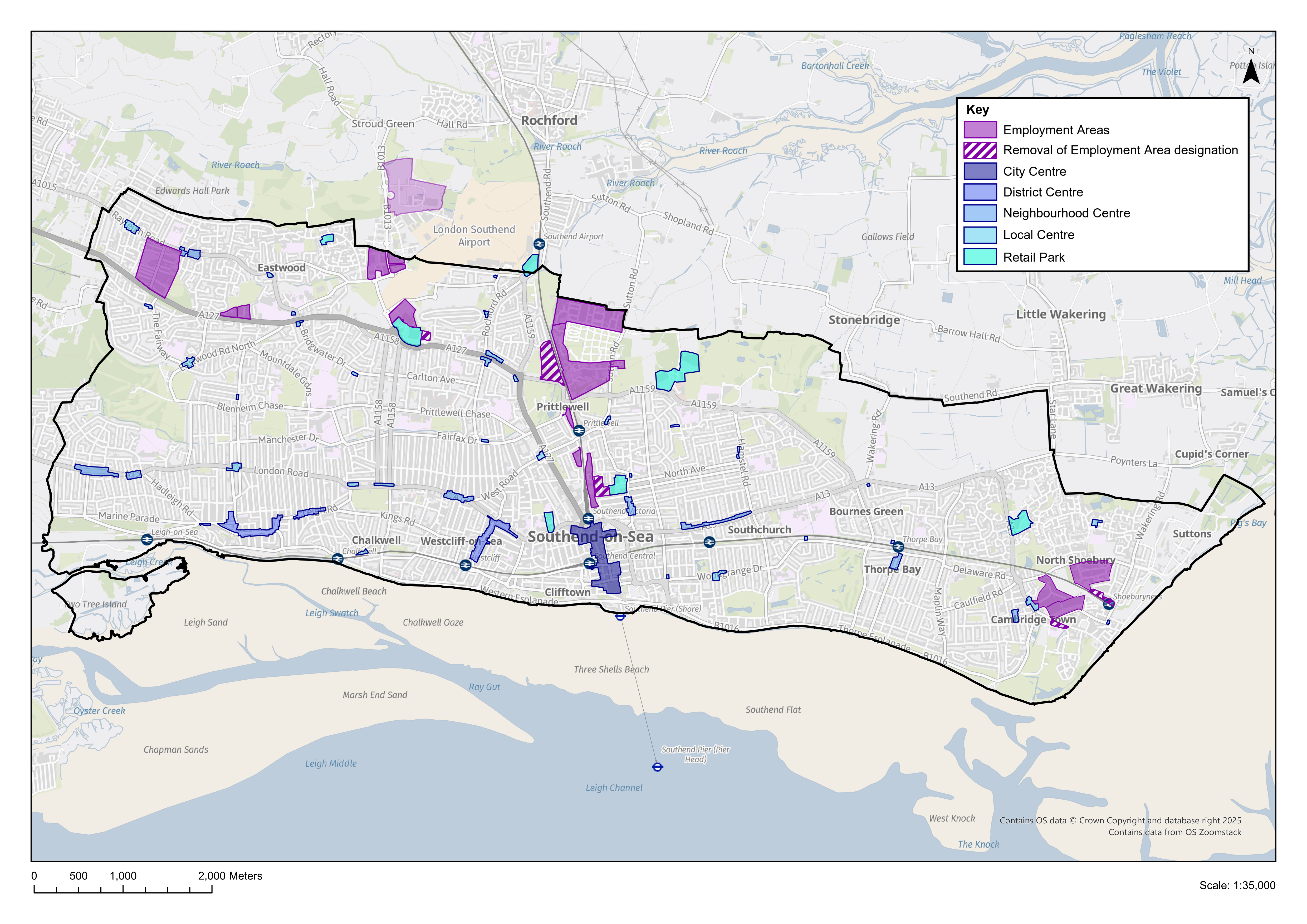
Why we have taken this approach
- 6.1 The NPPF requires Local Planning Authorities to set out a clear economic vision and strategy which positively and proactively encourages sustainable economic growth. As part of this the plan should set criteria, or identify strategic sites, for local and inward investment to meet anticipated needs over the plan period, seek to address barriers to investment, and to be flexible, enabling a rapid response to changes in economic circumstances, allowing for new and flexible working practices, and accommodating needs not anticipated in the plan. Planning policies are expected to recognise and address the specific locational requirements of different sectors, including provision for clusters or networks of knowledge, data driven, creative or high technology industries, storage and distribution at a variety of scales in sustainably accessible locations.
- 6.2 The Southend Economic Development Needs Assessment (EDNA) (2024) reports on a number of scenarios when estimating the need for future employment floorspace, including Cambridge Econometrics Economic Projections that estimates a need for approximately 7,500 additional jobs for Southend by 2040. Additionally, it also identifies several key economic sectors for Southend – these are set out in Policy Table DM6.1a, which identifies priority locations for these sectors.
- 6.3 The City Centre, London Southend Airport and associated business park, and the city's employment growth areas (Policy DM6.3 and Policy Table DM6.3b), are particularly well placed to achieve economic growth, with opportunities for increased modern employment floorspace. The EDNA recognises the role existing commercial centres across the city (particularly the City Centre) can provide in terms of flexibly meeting employment needs for Class E uses, including health service-based facilities, offices, leisure, higher education, restaurants and cafes. This should also help to contribute to the creation of complete neighbourhoods, ensuring the city's neighbourhoods benefit from good provision of services, including healthcare and education.
- 6.4 The City Centre will remain the first preference for all forms of commercial development and for other City Centre uses attracting large numbers of people, in accordance with Policies SP1, SP2 and the retail hierarchy set out in Policy DM6.4. It will be supported as a sub-regional centre providing the full range of high quality sub-regional services and facilities required to meet identified needs. There is also opportunity to introduce additional well designed residential and enhance the local environment in and around the City Centre, through urban greening and streetscape enhancements. The District Centres of Leigh and Westcliff will support the City Centre, providing for the day-to-day needs of local residents, complemented by the city's other Neighbourhood and Local Centre provision. The central seafront will complement this, providing a focus for tourism and leisure within the city.
- 6.5 There are number of key strengths in terms of the tourism offer of SouthendThe South Essex Tourism, Leisure and Recreation Strategy (2020), including the strong traditional day trip offer focussed to the central seafront, the Pier and adventure island; and other well-established visitor destinations including Leigh-on-Sea and Shoeburyness. A wide range of attractions, cultural provision and events programmes, the network of high quality open green spaces, all provide opportunities for enhancing the tourism offer. In addition, London Southend Airport provides the potential for growing national and international visitors to the city. Opportunities exist for further strengthening Southend's tourism, cultural and leisure offer, and Policy DM6.5 sets out the approach to managing tourism and visitor accommodation in the city, including short-term lets.
- 6.6 London Southend Airport and environs provides a strategic employment opportunity to support the delivery of a significant number of additional jobs, including employment directly related to the Airport. These jobs will contribute to the delivery of the jobs totals for Rochford District Council and Southend-on-Sea City Council as per the provisions in the airport adopted Joint Area Action Plan – the apportionment to each authority will be based on a 50-50 split of the overall jobs total to be provided within the JAAP area.
Have your say…
Please explain your answers
QSP6: Do you agree with draft Strategic Policy SP6: Securing a Thriving Local Economy and Visitor Destination? Please explain your answer.
Employment Sectors – development management policy
Reference to Strategic Objective and Strategic Policies
Strategic Objective 5
Strategic Objective 6
Strategic Objective 7
Strategic Objective 8
Strategic Objective 23
Why we need this Policy (justification)
6.7 This policy seeks to encourage economic growth, as well as identifying key economic sectors and priority locations for them in Southend. Enabling economic growth has a key role to play in levelling up disparities across the city and bringing about positive changes. The Southend Economic Growth Strategy (2024-2028) highlights the importance of supporting established businesses and organisations across the city to achieve sustainable economic growth, particularly within key economic sectors, and driving the development of local skills and training, employment and infrastructure. It recognises the important role of micro, small and medium enterprises within Southend, and promoting them to deliver a growing business base in the city. The Southend EDNA (2024) identifies several economic sectors for Southend, and priority locations for their growth, as set out in Policy Table DM6.1.
How the Policy Works
6.8 Sustainable economic growth will depend on building upon existing strengths, seizing new opportunities, helping businesses to grow locally, as well as supporting skills development. It is important to ensure there is sufficient flexibility within employment floorspace to enable emerging growth sectors to prosper. Development proposals will contribute positively and sustainably to achieving economic growth within Southend. A key element of this are the identified Key Employment Sectors and Priority Locations (Policy Table DM6.1) which are important to Southend's economy and future economic growth, and the Council will seek to promote these sectors and ensure that their location requirements are supported in a sustainable manner. It is recognised that there are other business areas that may develop/ grow within the city, and the Policy supports opportunities for sustainable economic growth, which can be achieved by increasing the capacity and quality of employment land, floorspace and jobs (Policy DM6.1.1). The Policy also recognises the potential for growth and regeneration within the Southend Central neighbourhood (including the City Centre), a sustainable location benefiting from existing shops, services and public transport provision.
Policy Table DM6.1: Key Economic Sectors and Priority Locations
|
Policy DM6.1: Employment Sectors
- Development will contribute to the promotion of sustainable economic growth by increasing the capacity and quality of employment land, floorspace and jobs.
- Southend City Centre and Southend Central Neighbourhood will form the primary location for major economic growth.
- To attract and promote investment and maximise benefits, development proposals within the Economic Sectors identified within Policy Table DM6.1 will principally be directed to the Priority Locations (Policy Table DM6.1).
Please explain your answers
Q6.1: Do you agree with draft Development Management Policy DM6.1 Employment Sectors? Please explain your answer.
Employment and Skills – development management policy
Reference to Strategic Objective and Strategic Policies
Strategic Objective 8
Policy SP6: Securing a Thriving Economy and Visitor Destination
Why we need this Policy (justification)
6.9 This policy seeks to manage skills development in Southend, recognising that Southend has a diverse workforce. There are many skilled workers in the city, however a significant proportion of these workers commute to jobs in London and other parts of South Essex. Lower skilled employment is more prevalent in Southend than nationally, with people working in Southend comparatively more likely to be employed in lower-skilled occupations and less likely to be employed in higher skilled, managerial and professional, occupations.
6.10 There is opportunity to improve the local skills base, attract new talent and improve access to training and high-quality jobs for employees, job seekers and students, as well as providing opportunities to upskill the workforce for local businessesSouthend Economic Growth Strategy (2024-2028). By harnessing the benefits of economic growth and working with partnerships and training facilities, the Council seeks to ensure provision of a broad range of employment and skills development opportunities are made available to local residents. This will include opportunities for skills development, training and employment during the construction phase of new development where appropriate and create a range of temporary and permanent employment opportunities at different skill levels.
How the Policy Works
6.11 Policy DM6.2 sets out the Council's emerging approach to skills development to ensure opportunities to up-skill local residents are realised. The policy approach sets out the intention that this will be supported by the preparation of Employment and Skills Plans (ESPs). Typically, an ESP will set out a framework for the delivery of employment and skills opportunities arising from a development, developed alongside a S106 agreement to include fee charging obligations, and enable its monitoring, and include an action plan, providing detail on how the development will deliver for local residents: construction apprenticeships, local employment opportunities during construction, construction work experience opportunities, end-use apprenticeships (for commercial development, as appropriate), monitoring information and timescales.
6.12 The ESP Fee will be contained within a S106 agreement and will be in line with the contribution schedule, options for which are set out in Policy Option DM6.2a and Policy Option DM6.2b below. This fee would be payable on commencement of the development and index linked from 1 April 2025 to the point at which it is paid/ subject to review. ESPs can help to increase local employment opportunities, raise skills levels, and address skills gaps. They offer potential to employ local people, providing them with work related training, and education opportunities.
Policy DM6.2: Employment and Skills
- Major development proposals must contribute to enabling access to employment and removing barriers to employment for local residents, facilitating skills and training development and supporting employment initiatives, including through the construction phase of new development.
Employment and Skills Plans (ESPs)
- Employment and Skills Plans (ESPs) that reflect local priorities will be required from all developments which:
- comprise 50 or more residential dwellings; or
- include more than 5,000sqm gross internal area of non-residential floorspace.
Fees
- Where an ESP is required, applicants will be expected to enter into S106 agreements so the Council can set out the fee contribution necessary to monitor the implementation of the Employment and Skills Plan (ESP). The fees applied will be subject to review:
Option A:
Policy Option DM6.2a - Proposed fee thresholds for ESPs
|
Residential Units (+VAT) |
Commercial Floorspace (+VAT) |
|
£100* per dwelling |
£1.25* per sqm |
*Subject to review.
Option B:
Policy Option DM6.2b - Proposed fee thresholds for ESPs
|
Number of Residential Units |
Total cost (+ VAT) |
|
50 - 100 |
£4,000 |
|
101 - 150 |
£6,000 |
|
151 - 200 |
£8,000 |
|
201 – 250 |
£10,000 |
|
250+ |
Price dependent on scale of development, available on request |
|
Commercial Floorspace (Sqm) |
Total cost (+ VAT) |
|
Up to 8,500sqm |
£8,500 |
|
8,500sqm+ |
Price dependent on scale of development, available on request. |
Have your say…
Please explain your answers
Q6.2a: Do you agree with the proposed policy approach to skills development in draft Development Management Policy DM6.2?
Q6.2b: Do you agree with Policy 6.2: Employment and Skills?
i. Does Option A provide the most suitable fee threshold for Employment and Skills Plans (ESPs)?
ii. Does Option B provide the most suitable fee threshold for Employment and Skills Plans (ESPs)?
Employment Areas – development management policy
Reference to Strategic Objective and Strategic Policies
Strategic Objective 5
Strategic Objective 21
Why we need this Policy (justification)
Safeguarding valuable employment land
6.13 This policy sets out the approach to managing the city's employment areas. Developable land in Southend is a scarce resource which needs to be effectively utilised to facilitate economic growth. Employment land in Southend has relatively lower land values compared to other land uses, such as residential, and as a consequence it is necessary for land in employment use or in desirable locations for employment development in market and sustainability terms, to be safeguarded or allocated as such in order to facilitate present and future economic growth, otherwise it is likely that this land will be developed for alternative uses. Given this, the city's existing designated Employment Areas have been reviewed to determine their 'health' and whether they continue to serve a clear purpose in terms of employment land and local jobs provision.
6.14 The city's Employment Areas (Policy Table DM6.3a) are recommended to be protected and maintained in employment use. The Employment Areas form a network of locations where new economic development and investment will be focused. The retention and provision of employment areas is necessary to enable balanced job and housing growth within Southend, in accordance with Strategic Policies SP5 and SP6. The Employment Areas contain a range of sites and premises that meet the needs of the business community. Within this context, the Employment Growth Areas (see Policy Table DM6.3a) are recognised for their potential to provide for increased/ modern employment floorspace, providing opportunity to intensify employment uses and make efficient and effective use of land for employment purposes.
6.15 There are several other employment areas within the city that fall under the category of industrial/ business estates (see Policy Table DM6.3a). These employment areas also provide an important economic function and should also be retained and protected for employment uses, although an increase in employment floorspace in these locations is not projected, they continue to serve business needs. Within all employment areas, it will be important to ensure that any new employment floorspace is designed to respond to changing economic conditions and supports economic growth. For example, by allowing capacity and flexibility for 'grow-on' space as well as larger footprint space where appropriate and having due consideration to the character and function of the relevant employment area.
6.16 Micro, Small and Medium Enterprises (SMEs) make an important contribution to the Southend economy. The Economic Growth Strategy (2024-2028) seeks to promote Southend as the home of such businesses, focusing on sectors that bring the greatest value. To facilitate growth, it is recognised that micro, small and medium enterprises are likely to require flexible layouts, with potential for incubator, micro spaces and 'grow-on' spaces, and flexibly designed, medium sized premises to meet the needs of businesses in the middle stage of growth. Consideration should be given to their provision within employment areas as appropriate (recognising that some existing employment areas, such as Vanguard Way, already include such premises).
Policy Table DM6.3a: Southend's Employment Areas
|
|||||||||||||||||||||
Potential employment land release
6.17 The Employment Site Release Topic Paper (2021) suggests a small number of self-contained, poorer performing employment areas (as previously designated in the development plan) where the employment area designation could be removed, to assist regeneration and having potential to deliver a mix of uses. These areas have been reviewedSurvey of Employment Areas, 2024 and further information is set out in Policy Table DM6.3b.
Policy Table DM6.3b: Existing Employment Areas to be removed from employment area designation
|
|||||||||||||||||||||
Permitted Development Rights
6.18 Recent changes to the Use Class Order in England have created a new 'Class E' which comprises commercial, business and service uses, replacing the former Class A and Class B1, while Class B2 and B8 uses remain as a current use class category. Under the General Permitted Development Order (GDPO), permitted development rights allow certain building works and changes of use to be carried out without the need for a full planning application. There is often a requirement for 'prior approval' for development carried out under permitted development rights. Appendix 8, Table DM6, sets out relevant use classes, and the permitted change of use within them (including where there is a requirement for prior approval).
6.19 Within the city's Employment Areas, changes to the Use Class Order, particularly the introduction of Class E and its incorporation of former Class B1 (office uses) enables the potential for more diversification to take place. For example, the introduction of residential uses, through Class MA, that may not be compatible with an area's use and function. This also applies to Class B8 (storage and distribution) uses that are often found in the Employment Areas, with PD Class L allowing for change of use to residential subject to the prior approval process.
6.20 To ensure that the Employment Areas are safeguarded, the Council will investigate the use of an Article 4 Direction as appropriate, particularly if there is a prevalence of Class E and Class B8 uses within an employment area that could, subject to the prior approval process, be permitted to change to residential use, which would be detrimental to an area's form and function and continued viability.
How the Policy Works
6.21 The Council will seek to retain class B2 and/ or B8 (and Class E(g)i-iii office uses as appropriate) uses in the Employment Areas (Policy Table DM6.3b), to ensure these areas maintain their role and function, providing a base for economic activity in the city. Where there are opportunities to redevelop poorer quality/ older industrial premises within the Employment Areas for employment use, the Council will encourage a mix of well-designed, flexible units that are suitable for Class B2 and/ or B8 (and Class E(g)i-iii as appropriate), making efficient use of land to support local business needs, including potential for flexible and grow-on spaces, and premises suitable for micro, small/ medium enterprises. In some instances, Sui Generis uses of an employment nature, suitable to the character and context of the Employment Area in question, may be appropriate, and this will be considered on a case-by-case basis, and in accordance with the provisions of Policy DM6.3. In cases where there it can be clearly demonstrated that there is no long term or reasonable prospect of a site being bought back into B class or E(g)i-iii use, in accordance with Policy DM6.3.3 and Appendix 6, marketing/ market demand evidence will be provided to the Council to clearly demonstrate that the property has been actively marketed for a minimum period of 1 year.
6.22 The Employment Growth Areas offer opportunities for employment growth, particularly B2 and/ or B8 (and Class E(g)i-iii office uses as appropriate). Development Proposals that fall outside of these employment use classes would not normally be supported unless certain conditions are met, for example in cases where the proposed use is of an employment nature and falls within the Sui Generis use class and would be compatible with the existing operating conditions of the employment area. Such a use may have the potential to complement the employment area and not detract from its function, while providing employment opportunities.
6.23 The Council will monitor and manage the function of the Employment Areas so that these areas continue to positively contribute to strategic and local economic objectives. Opportunities to enhance sustainable connections to the employment areas will be encouraged wherever possible.
6.24 Outside of the Employment Areas, in cases where a site is in employment use, or was last used for employment purposes (including employment uses of a Sui Generis nature), in order to retain employment premises within the city, there will be a need to demonstrate that it is no longer viable to accommodate or retain the use of the site for employment purpose, that use of the site for Class B2 and/ or B8 purposes would give rise to unacceptable environmental problems, and it can be demonstrated that an alternative use or mix of uses will give greater potential benefits to the community and environment than continued employment use (see Appendix 6, Part C).
6.25 It is recognised that Southend's Employment Areas are likely to have a different noise character to areas which are, for example, more residential in character. The potential provision of new residential properties, including property conversions, and other sensitive uses within or close to the Employment Areas will need to consider noise from established commercial units and premises (residential uses in Employment Areas will be resisted). The 'agent of change' principle will therefore apply (Policy DM9.3.7).
Policy DM6.3: Employment Areas
- Major development proposals within the city's Employment Areas (Policy Table DM6.3b), as defined on the Policies Map, should make provision for a range of flexible unit sizes, including accommodation that supports small and medium sized enterprises, to ensure the needs of businesses are met. This should take account of the location and type of business(es) proposed to ensure land is used efficiently. Where appropriate, incubator/ seedbed, 'grow on', and/ or affordable workspaces will be sought. Opportunities to enhance sustainable connections to the Employment Areas will be encouraged.
- The Council will investigate the use of Article 4 Directions where appropriate in the city's Employment Areas to ensure their commercial function is maintained and protected from loss of commercial premises through the introduction of residential uses.
- Support the retention, enhancement and development of Class B and Class E(g)i-iii uses within the city's Employment Areas (Policy Table DM6.3b) that contribute to the delivery of new jobs, in accordance with Policy SP6, and provide well-designed buildings and flexible layouts. Proposals that fall outside of a Class B and Class E(g)i-iii employment use will only be granted permission where:
- the development proposal is a 'Sui Generis' use of a similar employment nature, which is compatible with and will not compromise the operating conditions of the Employment Area; or
- the development proposal is in conformity with a planning brief, or similar document, that has been adopted by the Council for the concerned site, which sets out other appropriate uses; or
- it can be demonstrated to the Council's satisfaction that:
- there is no long term or reasonable prospect of the site concerned being used for Class B or Class E(g)i-iii purposes*; and
- the use is compatible with and will not compromise the operating conditions for other employment uses or the potential future use of neighbouring sites for employment uses; and
- the alternative use cannot be reasonably located elsewhere within the area it serves**; and
- the use will not give rise to unacceptable traffic generation, noise, odour or vehicle parking; or,
- the development will be a complementary and supporting use, which is both subservient and ancillary to the principal employment use and serves the daytime needs of the employment area's working population and will not result in a material change to the character and function of the area.
- The Employment Growth Areas (Policy Table DM6.3b) will be promoted as locations for increased modern employment floorspace.
- The Employment Areas should remain the primary focus for employment uses. Proposals for employment generating uses located outside of the Employment Areas will be permitted in principle where they do not impact upon the amenity of the surrounding uses and do not conflict with other local plan policies and in line with Policy SP1 and SP2.
- Outside the Employment Areas, proposals for alternative uses on sites used (or last used) for employment purposes, including sites for sui generis uses of an employment nature, will be permitted where it can be demonstrated that:
- it will no longer be effective or viable to accommodate the continued use of the site for employment purposes***;
- use of the site for Class B use gives rise to unacceptable environmental problems; and
- an alternative use or mix of uses will give greater potential benefits to the community and environment than continued employment use.
- Development proposals for sensitive uses, including residential, in close proximity to or within the Employment Areas, must not put at risk the survival of uses and existing industries which are important to the city's economy and the Agent of Change Principle will apply (Policy DM9.3).
* This should include a minimum 1-year active marketing exercise where the vacant site/ floorspace has been offered for sale or letting on the open market at a realistic price and that no reasonable offers have been refused. In exceptional cases related to site specific circumstances, where the vacancy period has been less than 1 year, a robust market demand analysis which supplements any marketing and vacancy evidence may be considered acceptable. Appendix 6 Part A and B set out the information to be provided in relation to marketing and market demand.
** The Council will make a judgement about the extent of the area based upon the sites' characteristics and the proposed use.
*** Appendix 6 Part C sets out the information to be provided as part of this appraisal.
Have your say…
Please explain your answers
Q6.3: Do you agree with draft Development Management Policy DM6.3 Employment Areas? Please explain your answer.
Retail/ Commercial Centres and Frontages – development management policy
Reference to Strategic Objective and Strategic Policies
Strategic Objective 5
Strategic Objective 6
Strategic Objective 8
Strategic Objective 13
Why we need this Policy (justification)
6.26 This policy sets out the retail hierarchy for Southend and the approach to managing retail/ commercial centres across the city, recognising the role they play in providing shops and services for the communities that they serve. It identifies the key role Southend City Centre has as a sub-regional centre, providing a range of shops, services and leisure opportunities for Southend's residents and visitors.
6.27 The changing nature of the 'High Street', facing competition from online shopping, changing shopping patterns and habitats, the impact of the Covid-19 pandemic and economic downturn, together with competition from retail parks and centres outside of the city, has impacted upon the level of trading in Southend City Centre, and the quality of provision. There is subsequently a need to upgrade, enhance and broaden its offer and function, to help to drive footfall and bring about regeneration through the day and evening economies. Policy DM6.4 seeks to maintain and enhance the attractiveness of the City Centre, and the city's district, neighbourhood and local centres, by encouraging active retail and commercial uses, particularly at ground floor within Class E use, within these retail/ commercial centres.
6.28 Existing premises, and planning permissions, are expected to accommodate the projected growth for retail and food/ beverage uses, particularly in the short term. In addition to this, vacant floorspace is likely accommodate future residual growth. There is no pressing need to bring forward major new allocations for retail and food/ beverage development in the city to 2035 (and in the longer term, retaining retail floorspace should be considered to accommodate residual needs through the re-occupation of vacant floorspace, as well as potential site allocations within Southend Central providing opportunity for retail, food/ beverage, and leisure uses)Southend Retail and Leisure Needs Assessment Update (2022).
6.29 Policy Table DM6.4a sets out the hierarchy and network of retail/ commercial centres in the city.
Policy Table DM6.4a: Retail Hierarchy
|
||||||||||||||||||||||||||||||||||||||||||||||||||||||||||||||||||||||||||||||||||||||||||||||||||||||||
6.30 As part of the preparation of the Local Plan, the city's retail/ commercial centres were surveyed to determine their current 'health'. As part of this work, one small, local centre (Victoria Avenue/ Fairfax Drive) was identified that has a significant proportion of vacancies. This is recommended for release from its designation as a centre/ retail frontage, as set out in Table DM6.4b belowReview of Retail/ Commercial Centres and Retail Parks, 2024.
Table DM6.4b: Centre to be released from retail frontage designation (as defined by Development Management DPD)
|
Name of Centre |
Justification |
|
Victoria Avenue/ Fairfax Drive |
This Local Centre comprises 8 units, the majority of which are vacant and have been vacant for a number of years. A proportion of the centre is also in residential uses. It is recommended that the centre is released from its retail frontage/ centre designation to allow for regeneration for other uses. The centre should not be designated as such within the Local Plan. |
Use Class Order and Permitted Development Rights
6.31 Within the city's retail/ commercial centres, changes to the Use Class Order (see Appendix 8) enables the potential for more diversification to take place to include a broad range of commercial uses (including retail) within Class E, which contribute to the health and vitality of centres. However, it also allows for the potential for Class E uses, including retail premises, to change to residential through permitted development rights within Class MA. This could have the impact of creating areas of non-commercial, inactive frontage within the centres, detracting from the vitality and viability of the centres and the role they play in providing shops and services to the local communities that they serve, which are sustainably accessible (and, in the case of the City Centre, its role as a sub-regional centre serving a wider population). While residential development can contribute to the health of centres by providing opportunities to live in some of the city's more sustainable locations, and contribute to local housing need, residential development should only be provided above ground floor within the centres to ensure that active, continuous commercial frontages (primarily within Class E uses) are retained at street level to support footfall. Within all retail/ commercial centres therefore, change of use to residential at ground floor will be resisted to maintain vitality and viability.
6.32 The Council will investigate the use of Article 4 Direction(s) as appropriate, within designated centres to restrict permitted development rights within Class MA that would allow the change of ground floor retail and commercial uses (Use Class E) to residential (Use Class C3) without the need for planning permission, in order to maintain the vitality and viability of these well-established, historic commercial centres and the role they play in creating complete neighbourhoods where shops and services are within easy walking/ cycling distance for residents.
Meanwhile Uses ('Pop-Ups')
6.33 'Meanwhile uses' are introduced for a temporary period. They are sometimes referred to as 'pop-ups' and can play an important role in bringing vacant premises back into short-term use by providing space for local start-ups and/ or small, independent businesses, or to accommodate a use that is intended for a limited time only, like an art display, for example. They can provide locations for community spaces, incubator hubs, art and cultural facilities, and affordable workspaces.
Sui Generis Uses
6.34 While some Sui Generis uses may support the function of a centre, such as a theatre or cinema, there are other uses within this class that can have an adverse cumulative impact on the function of a centre and the health and wellbeing of the local population. Betting Shops, Adult Gaming Centres and Pay Day Loan Shops are classified as Sui Generis uses. Planning permission is required for a change of use within the Sui Generis use class, and for change of use from other uses.
6.35 To ensure the function, vitality and viability of the city's retail/ commercial centres is maintained, in the interests of health and well-being, and to protect amenity within these centres, Policy DM6.4 seeks to avoid an over-concentration of these uses to avoid adverse cumulative impacts. The Council will therefore consider planning applications for these uses on their merits, based on a review of the concentration of similar uses (with a separation distance of at least two units in other uses), impact on amenity, proximity to sensitive uses, and against other relevant Local Plan policies.
Retail Parks
6.36 There are several retail parks (Table DM6.4c) across the city that provide some large format units, often occupied by comparison goods stores, and some complementary smaller uses including food outlets, and associated areas of surface level parking. Proposals to locate or expand main town centres uses outside of the defined hierarchy of centres, within the Retail Parks, will be required to demonstrate through a sequential assessment that there are no sequentially preferable sites available to ensure that the vitality and viability of the city's network of centres is not adversely impacted.
Table 6.4i: Retail Parks
|
Name of Retail Park |
Neighbourhood |
|
Western Approaches |
Eastwood |
|
Thanet Grange |
Prittlewell |
|
Airport Retail Park |
Prittlewell |
|
London Road Retail Park |
Southend Central |
|
Greyhound Retail Park |
Southend Central |
|
Fossetts Retail Park |
Fossetts |
|
North Shoebury |
Shoeburyness |
How the Policy Works
6.37 Southend City Centre's role is as a sub-regional centre, and it will be the first form of preference for all forms of retail development and other town centre uses attracting large numbers of people. Map DM6.4 shows the extent of the City Centre's defined Primary Shopping Area, together with areas of defined Primary Shopping Frontage within it that will allow for a strengthened retail presence, supported by areas of Secondary Shopping Frontage. Development within the City Centre should be in accordance with the spatial strategy set out in Policy SP2. New retail and commercial development should be well integrated and closely linked with the City Centre Primary Shopping Area. The City Centre will provide the full range of high-quality sub-regional services and facilities required to meet identified needs for retail, health, food and drink, professional and financial services, leisure, cultural and higher education services, and homes (above ground floor).
6.38 The District Centres of Leigh-on-Sea and Westcliff will continue to support the City Centre, providing a range of local comparison shopping and services. There is little scope for significant additional floorspace within these centres and any expenditure growth should be used to support the vitality and viability of existing floorspace. Parts of both District Centres are designated as Conservation AreasLeigh and Leigh Cliff Conservation Areas form part of Leigh District Centre; Hamlet Court Road Conservation Area forms part of Westcliff District Centre., which form the primary shopping areas, and there are other heritage assets within them including locally designated Frontages of Townscape Merit. These are well established, historic retail/ commercial areas and the provision of continual retail/ commercial frontage forms an important part of their character, and development proposals within the Conservation Areas or affecting a heritage asset should have regard to the provisions of Policy DM7.6, conserving these assets, providing opportunities for enhancement as appropriate.
6.39 Existing centres elsewhere within the city will be supported as Neighbourhood and Local Centres and will meet the day-to-day convenience and community needs, primarily providing top-up food, convenience shopping and local services. Ground floor uses will be encouraged within Class E to support footfall and development proposals will maintain active, shop frontages and provide a direct service to visiting members of the public.
6.40 Ground floor residential conversions will be resisted within all retail/ commercial centres and a strong provision of Class E uses, including retail, should be maintained. The Council will investigate the use of an Article 4 Direction within designated centres, to remove permitted development rights for ground floor conversions to residential within Class MA.
6.41 The policy approach to the design of shopfronts and advertisements is set out in Policy DM7.4. The Council will expect any new or replacement shopfronts to be of a high standard of design, respecting the character of the building and adjoining properties.
6.42 The Council will keep retail floorspace requirements and the health of the centres, and the retail hierarchy, under review over the plan period.
6.43 'Meanwhile uses' will be supported in the short term where they provide activity and interest to vacant units within the centres. It is important to ensure that meanwhile uses do not have a negative impact on the amenity of neighbouring uses, including residential properties, and do not prevent a sites' development from being brought forward. As such, meanwhile uses, where acceptable in principle, will normally be granted temporary permission to ensure that their impact can be regulated and/ or to control the length of time that such uses occupy a unit(s).
6.44 It is recognised that Southend's retail/ commercial centres are likely to have a different noise character to areas which are, for example, more residential in character. The design of new residential properties, including property conversions, within or near these centres will need to consider noise from established commercial units and premises. The 'agent of change' principle will therefore apply (Policy DM9.3.7).
6.45 Any development proposal for town centre uses outside the retail/ commercial centres will be subject to sequential testing, impact assessment, and will be expected to demonstrate that there is a need for the proposed development, it would not harm the objectives of safeguarding the vitality and viability of the City Centre, District Centres, Neighbourhood and Local Centres, would be accessible by a range of sustainable transport options, and would not have a significant impact on the local transport network and local parking provision. This includes proposals within retail parks for example, and where a development proposal within a retail park (Table DM6.4c) is acceptable in principle, it will be expected to demonstrate that it satisfies the requirements of DM6.4.5. In such cases, sustainable access, public realm and urban greening enhancements will be encouraged, ensuring attractive and safe pedestrian and cycle routes are provided into and through the retail park.
6.46 The Council recognises the role street markets can play in adding to the vitality and viability of the City Centre and will seek to maintain and enhance street market provision within the City Centre Primary Shopping Area. Proposals for street market provision outside of this area will be considered on its merits.
Map DM6.4: Southend City Centre Primary Shopping Area
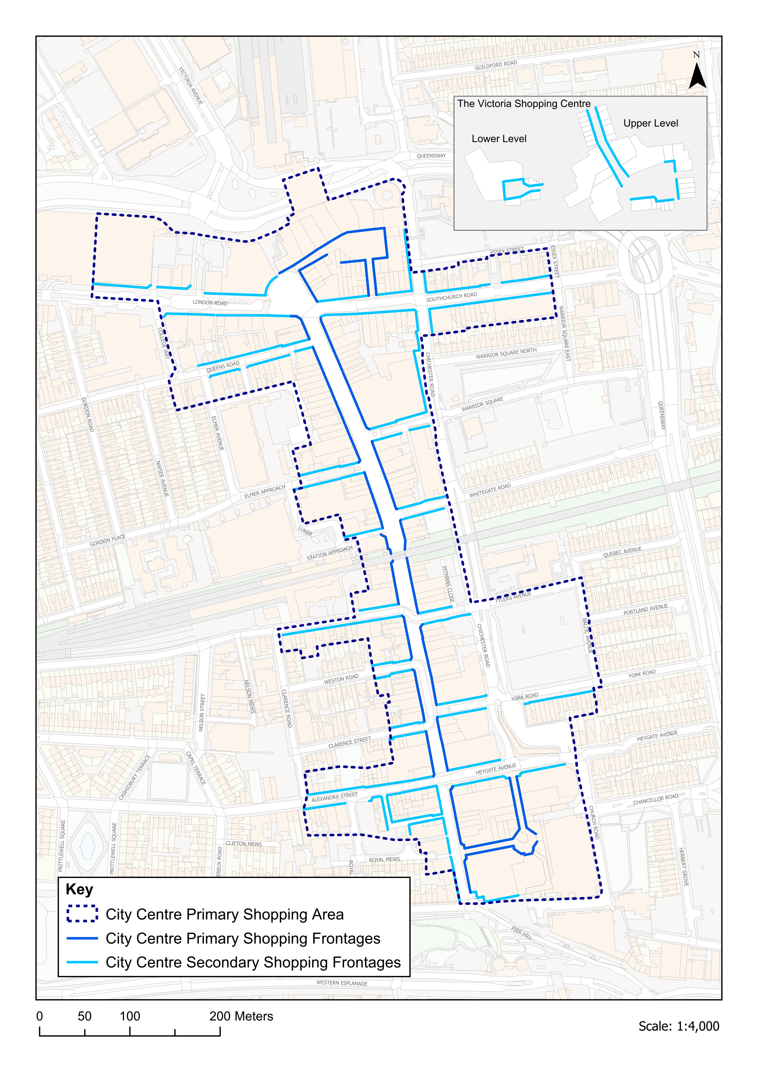
Policy DM6.4: Retail/Commercial Centres and Frontages
- The following hierarchy of centres (as defined on the policies map) applies in Southend (Policy Table DM6.4a):
- Southend City Centre will remain the first preference for retail and other main town centre uses attracting large numbers of people in both the daytime and evening economies. It will be supported and developed in accordance with the spatial strategy (Policy SP2) as:
- a sub-regional centre providing the full range of high-quality sub-regional services and facilities required to meet the needs for retail, commercial, business and services uses (Class E use), education and non-residential institutions (Class F1 use), and opportunities for leisure, and good quality mixed use development to secure new jobs, and new homes (above ground floor); and
- the key focus and driver for the regeneration of Southend. The Council will promote the City Centre in seeking to upgrade its offer and encourage investment. New retail and commercial development must be well integrated and closely linked with the City Centre Primary Shopping Area (as defined on the policies map) in terms of proximity, continuity of function and ease of access. The Council will promote the City Centre in seeking to upgrade and diversify its offer;
- The centres of Leigh and Westcliff will be supported as District Centres to support footfall and offer a range of shops and services (maintaining a strong provision of Class E uses) to the local community;
- Existing centres elsewhere will be supported as Neighbourhood and Local Centres, meeting the day-to-day needs of local communities, and should continue to provide a retail and commercial offer.
- Southend City Centre will remain the first preference for retail and other main town centre uses attracting large numbers of people in both the daytime and evening economies. It will be supported and developed in accordance with the spatial strategy (Policy SP2) as:
- The Council will investigate the use of Article 4 Direction(s), within designated centres, particularly within the primary shopping area of the City Centre and District Centres, to require planning permission to be sought for proposed change of use at ground floor from retail/ commercial (Use Class E) to residential (Use Class C3) within Class MA to ensure the vitality and viability of centres is maintained, with continual active frontage, contributing to complete communities.
- Within designated retail/ commercial centres, existing frontages will be managed to reinforce and enhance their attractiveness, and contribution they make to the vitality and viability, and resilience, of the centres within the daytime and evening economies. Frontages will maintain a strong provision of retail and supporting Class E commercial uses to encourage footfall. Development proposals will address the following principles:
- maintain and promote the continuity of active frontages, including through the retention or provision of an active ground floor shopfront that allows for a display function for goods and service rendered, and provides a direct service to visiting members of the public (see Policy DM7.4);
- the frontage will be of a high standard of design that is compatible with the architectural style of the building and surrounding area, including in terms of alignment and proportions (in accordance with Policy DM7.4).
- where a development proposal involves a heritage asset, have due regard to the continued conservation of this asset, and opportunities for appropriate enhancements, in accordance with Policy DM7.6;
- within all retail/ commercial centres, residential conversions of ground floor frontages will be resisted in order to maintain viability and vitality;
- not lead to an overconcentration or clustering of betting shops, pay day loan shops, and/ or adult gaming centres (Sui Generis uses), ensuring a separation distance of at least two units in other uses is maintained;
- not cause detrimental impact to those living or working nearby, for example by causing undue noise, odour, and/ or disturbance.
- Within the retail/ commercial centres, sensitive uses, including residential (particularly in the City Centre) must not put at risk the survival of uses such as music venues, clubs and existing industries which are important to the city's cultural diversity and night-time economy (see Agent of Change Principle, Policy DM9.3).
- All proposals for main town centre uses outside of the retail/ commercial centres (Policy Table DM6.4a), including edge of centre development, development within retail parks, and out of centre development, will be subject to sequential testing in accordance with the NPPF. Development will only be permitted where:
- it can be demonstrated to the satisfaction of the Council that there is a need for the proposed development;
- it can be demonstrated that the proposal satisfies the sequential test;
- it can be demonstrated through an impact assessment that the proposed development would not put at risk or harm objectives to safeguard the vitality and viability of the City Centre, district, neighbourhood and local centres; and
- the development would be accessible by a range of sustainable transport options and will not have a significant impact on the local transport network and existing local parking provision;
- Within the city's retail parks, proposals will be assessed on a case by case basis, taking into account the nature of the goods to be sold, and the accessibility of the site. Opportunities to enhance the public realm and access to retail parks will be encouraged.
- Temporary and 'meanwhile' use of vacant buildings in the retail/ commercial centres will be supported in the short term where it can be demonstrated that the use of the building would contribute to the vibrancy and vitality of the centre, creating visual interest, and would not harm the amenity of neighbouring uses, particularly residential development.
- The Council will seek to maintain and enhance street market provision within Southend City Centre Primary Shopping Area. Proposals for street market provision elsewhere within the City Centre will be considered on its merits.
Have your say…
Please explain your answers
Q6.4a: Do you agree with Development Management Policy DM6.4 Retail/ Commercial Centres and Frontages? Please explain your answers.
Q6.4b:
i. Do you agree with the proposed use of Article 4 Directions within the primary shopping areas of the City Centre, and within the District Centres of Leigh and Westcliff? Please explain your answer.
ii. Do you think this should be extended to other centres in the retail hierarchy, such as neighbourhood and local centres?
Tourism and Visitor Accommodation – development management policy
Reference to Strategic Objective and Strategic Policies
Strategic Objective 5
Strategic Objective 6
Strategic Objective 7
Strategic Objective 8
Strategic Objective 10
Strategic Objective 11
Strategic Objective 18
Strategic Policy SP6: Securing a Thriving Local Economy
Why we need this Policy (justification)
6.47 Tourism, together with leisure, cultural and creative industries, is an important part of Southend's identity and of its economy with a strong traditional day visit offer attracting an estimated 7 million daytrips per year. The Southend Culture Vision recognises that the city's cultural and creative industries have significant employment and wealth generating capacity, and the ability to create a step change, retaining and attracting new visitors to Southend. There was also over 200,000 overnight trips in 2022Destination Research – Economic Impacts of Tourism Southend 2022 with opportunities to grow this sector and encourage longer and overnight stays.
6.48 Destination Southend (2020-2050) highlights that significant investment in recent years have provided firm foundations for a stronger and broader tourism offer that supports jobs, growth and communities across the city. It seeks to raise the profile of Southend, attracting investment and reinvestment into the city, and broadening its appeal. The Economic Impact of Tourism, Southend (2022) reports that tourism related jobs accounted for 16% of the city's total employment in 2022, and while the tourism market continues to recover following the covid pandemic, the number of day trips and overnight stays have been increasing to near pre-pandemic levels.
How the Policy Works
6.49 The Central Seafront Area will continue to be the primary focus for the further enhancements of tourism, cultural, leisure and recreational attractions and facilities in accordance with Strategic Policy SP2, with the aim of promoting Southend as a major vibrant visitor resort and destination (see also Southend Central Neighbourhood Policy N5b). The City Centre also plays an important role in Southend's appeal, with shops, food and drink and leisure provision, and there may be opportunities for this role to be further enhanced (see Policy N5a).
6.50 There are other areas of the city that provide a focus for leisure and tourism too. Leigh-on-Sea is a visitor destination in its own right, based on the appeal of Leigh District Centre and Old Leigh as an historic centre and an active working fishing port ('Leigh Port' – home to traditional fishing industries) (see Neighbourhood Policy N2). Shoeburyness's offer is that of a coastal park with a range of quality natural, cultural and heritage assets. Improving and promoting the green space offer of Shoeburyness and its beaches for leisure and recreation, together with the heritage and cultural offer of places like Shoebury Garrison, will be promoted (see Neighbourhood Policy N9). Proposals to enhance and improve tourism facilities in these locations will need to be sensitively designed and establish a clear relationship with the seafront.
6.51 The city benefits from a range of cultural facilities and events, including the Pier, theatres, art galleries and museums. The city's cultural offer is recognised for the role it can play in attracting visitors, and supporting regeneration, including through events at key venues including the Pier, Cliffs Pavilion and Palace Theatre, as well as pop-up uses in vacant shopfronts for example. The Council will encourage the provision of space for cultural and creative industries as part of development proposals, particularly within the Central Seafront and City Centre, to contribute to regeneration and further consolidate its visitor offer (see also Policy DM6.4).
6.52 The city is home to a range of attractive parks and open spaces, including woodland and nature reserves. These provide an important part of the Southend's visitor offer, and informal recreational use of the foreshore and estuary takes place along almost the entire length of the seafront. Indeed, their leisure function has happily co-existed with nature conservation principles and values and has done so for many years.
6.53 Growth in tourism needs to consider impacts on the natural environment and local communities, including through increased car trips and congestion, which can in turn have an impact on air quality and how the highway network operates. This can lead to parking difficulties, which can affect the local environment, and residents and visitors experience of the area. It remains essential to grow tourism in a sustainable way, to balance regeneration, tourism and recreational opportunities with biodiversity and natural resourcesSouthend Seafront includes a number of important environmental designations including Benfleet and Southend Marshes Ramsar Site; Benfleet and Southend Marshes Special Protection Area; Southend-on-Sea Foreshore Local Nature Reserve. , and the needs of local communities. The provisions of Policy DM8.4: Southend Foreshore and DM10.4: Parking Standards (as well as Policies N5b: Central Seafront area and N5d: Southend Central Car Parking) will be applied to ensure an appropriate balance is struck.
Hotel and Visitor Accommodation Locations
6.54 There is a need to prioritise hotel and visitor accommodation within key areas, where such development can deliver greatest benefit. The central seafront area, and wider City Centre, will be the main focus for the city's tourism offer, complemented by appropriately located hotel and visitor accommodation in Southend Central neighbourhood and locations with good access and a clear and strong relationship with the seafront, where required.
6.55 Hotel and visitor accommodation will be prioritised within the 'Key Areas', particularly within the Southend Central neighbourhood, as set out in Policy Table DM6.5. The expansion of the airport and associated business parks will help support hotel development that is directly associated with the airport's operations. To ensure new visitor accommodation is in sustainable and accessible locations, the Council will expect development proposals for visitor accommodation to relate well with the city's strategic routes and distributor roads. Outside of these areas, further hotel development will be discouraged as this would compete for a share of market, and would undermine potential growth in the Key Areas, having a detrimental impact on sustainable tourism and economic growth in the city.
Policy Table DM6.5: Key Areas for Visitor Accommodation in Southend
|
Key Areas for Visitor Accommodation in Southend |
|
Southend Central neighbourhood (City Centre and Central Seafront) |
|
London Southend Airport |
|
Leigh and Westcliff District Centres |
|
Locations with good access and a clear and strong relationship with the Seafront* (*the Seafront is not considered in this context as a defined area, but as relating to an area that clearly has a strong relationship with the Seafront, which will be considered on a site-by-site basis and will take account of an area's function and connectivity with the Seafront, and specifically whether there are clear, convenient and direct walking routes to the Seafront). |
Viability Assessment for visitor accommodation
6.56 The loss of visitor accommodation could have an adverse impact on the resort character and economy within Southend. The Council will protect sites used, or last used, for visitor accommodation within the 'Key Areas for Visitor Accommodation in Southend' (as defined in Policy Table DM6.5a) unless non-viability can be demonstrated. Regarding meeting the requirements of Policy DM6.5.7(a), applications for change of use will need to be accompanied by:
- Proof of marketing for sale - for a continuous period of at least 1 year at a competitive price taking account of current trading performance and condition (Appendix 6, Part A, sets out the information to be provided in relation to marketing);
- Evidence of business performance – including, details of occupancy and achieved occupancy rate data for the last year along with accounts to explain how the business is performing in line with levels of occupancy typical of industry/ destination norms; and
- Evidence of professional management – this includes details of marketing and business plans for the last year to demonstrate investment plans and attempts made to attract business.
6.57 The Council will encourage an open book approach and may seek independent advice, funded by the applicant, to test the veracity of any viability assessment. This verification will assess the accuracy and robustness of the matters listed above.
6.58 It is recognised that for smaller 'lifestyle' businesses, commercial viability is more difficult to test. In such cases proof of marketing for sale with specialist and local agents at a realistic price may be sufficient on its own. The Council will be flexible in its approach and have regard to all material considerations at the time of the application. In all instances the level of information required should be agreed with the Council prior to submitting a planning application.
Short Term Lets
6.59 A short term let, or short stay accommodation, is a property or room that is rented out for a short period of time, usually ranging for one or two nights to a few weeks. While short term lets can play an important role in supporting the local visitor economy, a high concentration of short term lets in coastal destinations, like Southend, can have an adverse impact on the availability and affordability of homes for local people, as well as having a potential impact on the character and amenities of established residential areas, for example through noise disturbance or additional parking pressure.
6.60 The previous Government consulted on introducing a requirement that planning permission be sought for short term lets where these are to be used as such for over 90 days per yearFollowing a change in UK government in 2024, the outcomes of this consultation have not yet been published and further announcements may be forthcoming., and proposed introducing a register for short term lets in an area. In order to manage any potential impacts of short term lets, Policy DM6.5.8 sets out policy criteria for their management, seeking to ensure that – where planning permission is required for the development of a short term let, or change of use to a short term let from an existing residential use, consideration is given to any impact this would have on local housing supply, and whether such a use – or collection of uses – would lead to impacts on the character and amenity of an area, particularly in terms of noise, parking stress, and any associated impacts on the local highway network.
Policy DM6.5: Tourism and Visitor Accommodation
Tourism
- The primary focus for new and enhanced tourist attractions will be the Central Seafront*, and the Council will safeguard its tourism function. Opportunities for new and enhanced tourism facilities will be promoted within this area, as well as the City Centre and the wider Seafront area (including Leigh-on-Sea and Shoeburyness), where they are of a scale, type and appearance appropriate to the location, and support the city's role as a year-round destination for day and longer stay visitors, and to increase overall spend.
- All major development proposals for tourism and related development must contribute to broadening travel choice and resilience, including the improvement of sustainable and active travel opportunities for visitors.
- Provision of space for cultural and creative industries, including workspace, will be promoted within major developments, particularly within the City Centre and central seafront.
- The foreshore and the city's public open green spaces, including parks and gardens, will be protected and enhanced as a leisure and recreational resource (Policies SP8 & DM8.4). Opportunities to enhance sustainable travel links between the city's public open green spaces will be encouraged.
Visitor Accommodation
- New visitor accommodation and facilities will be focused within Southend Central Neighbourhood, London Southend Airport, the District Centres of Leigh and Westcliff, and at locations with good access and a clear and strong relationship with the Seafront (the 'Key Areas' identified in Policy Table DM6.5a). Proposals for new accommodation must be inclusive and accessible, relating well to the strategic routes and the distributor road network, having good public transport accessibility, and meet the requirements of other relevant planning policies.
- Within the 'Key Areas' (Policy Table DM6.5), visitor accommodation will be retained. Proposals for alternative uses of sites used (or last used) for visitor accommodation will be considered where it can be demonstrated that:
- the site is no longer viable or feasible for visitor accommodation**; and
- the proposal meets all other relevant planning policies.
Where an alternative use is considered acceptable by the Council, applications that will contribute positively to the leisure, recreation and tourism offer in the city will be considered favourably.
- Proposals for alternative uses on sites used (or last used) for visitor accommodation outside the 'Key Areas' will generally be permitted provided that the proposal meets other relevant planning policies.
- Development proposals that involve a change of use from housing to short stay holiday rental accommodation that is to be used for more than 90 days per year, will be considered against the following criteria:
- the impact of such a change on the existing housing stock and local housing need; and
- the impact of the proposed development on the amenity of surrounding residents, particularly in terms of noise, parking stress, and local traffic impacts.
*Proposals should have regard to Policy N5b: Central Seafront and Policy N5d: Southend Central Car Parking Provision.
**See Appendix 6, Part A for information that must be provided.
Please explain your answers
Q6.5: Do you agree with draft Development Management Policy DM6.5 Tourism and Visitor Accommodation? Please explain your answer.
7. Urban Design, Character and Heritage
A CITY TO BE PROUD OF
7a. This chapter looks at local character and how we successfully manage the continued evolution of the city, its built heritage, and how future design and the quality of place can positively impact communities where all are welcomed to live, work and visit, in an attractive environment and where the past is valued.
Strategic Policy
Where we are now
The key issues to be addressed to ensure Southend's spatial vision is realised are:
- Ensuring buildings and places are well designed, cherishing our coastal identity and the unique character of our neighbourhoods;
- Celebrating Southend's rich heritage, supporting the regeneration and transformation of the City Centre as a thriving commercial centre, resort and residential area;
- Conserving and enhancing Southend's built heritage, with new buildings and spaces that respect and complement local distinctiveness;
- Ensuring Southend's neighbourhoods provide homes that are adaptable and flexible to meet the needs of people at all stages of their life.
Where we want to be
Strategic Objective 11
Strategic Objective 12
Strategic Objective 13
Strategic Objective 14
Strategic Objective 15
Strategic Objective 16
Strategic Objective 17
Key Supporting Documents
Key supporting documents that underpin the policies are available on the Council's Evidence Documents | Southend Local Planhttps://localplan.southend.gov.uk/evidence-documents, particular under the heading 'Facilitating good design, healthy living and built heritage'.
How we are going to get there
Strategic Policy SP7: Urban Design, Character and Heritage
Design Quality and Public Realm
- Development proposals will respond to and enhance local character and distinctiveness, providing for good quality design (Policy DM7.1), and must:
- have due regard to all relevant design guidance, design codes, and masterplans, including their impact on heritage assets (Policy DM7.6);
- make a positive contribution to the surrounding public realm (Policy DM7.1);
- incorporate landscaping and tree planting as an integral part of the design (Policy DM7.1 and DM8.5); and
- incorporate inclusive and active design that contributes to complete and accessible neighbourhoods and supports the health and wellbeing of residents (Policy SP4).
- Development must consider safety, inclusivity and accessibility from the outset, providing a high standard of amenity for existing and future users, and access for all, while having regard to the transition to a low carbon future in a changing climate (Policy DM9.1).
- Pre-application discussion will be encouraged by the Council and should take place at an early stage in the design process. Engagement with Design Review Panels will be encouraged, particularly for larger scale development (50+ residential units) or sensitive sites with complex issues (for example those involving heritage assets), to ensure a high standard of design is achieved.
Efficient and Effective Use of Land
- The Council will support well-designed development that optimises the use of land in a sustainable manner, responds positively to local context and does not lead to the over-intensification of development which would result in undue stress on local services and infrastructure, including transport capacity (Policy DM7.2).
Tall Buildings
- Tall Buildings will be supported in Southend City Centre and Central Seafront area and will only be considered in other locations in exceptional circumstances. All proposals for tall buildings will be subject to the locational and design criteria set out in Policy DM7.3.
Advertisements and Shopfronts
- Where advertisement consent is required, the Council will support proposals that respect the interests of public safety and amenity, and meet the criteria set out in Policy DM7.4. Where considered acceptable in principle, replacement shopfronts must be of a high quality of design, maintaining an active frontage, and relate positively to the building, addressing the criteria set out in Policy DM7.4.
Refuse and Recycling
- Development proposals must consider and demonstrate the type and quantity of recycling and waste which is likely to be produced by the building and how it will be stored and collected, in accordance with Policy DM7.5. Accessible and convenient storage will be fully integrated into the development in a way that does not compromise local character or the design of the building.
Public Art
- Public art can make a positive contribution to the local area, and its provision should include engagement with the local community, and collaboration with local artists will be encouraged. All development proposals of 50 or more residential units, and/or 5,000sqm or more non-residential floorspace will be expected to include public art (or contribute towards its provision) and integrate this into proposals at an early stage in the design process, ensuring it is visible from and integrates well with the public realm.
Heritage
- The historic environment forms an important part of the city's identity, creating a strong sense of place. Designated and non-designated heritage assets are a finite resource and must be conserved, and enhanced, to enable them to be enjoyed for years to come, in accordance with Policy DM7.6.
Why we have taken this approach
7.1 High quality, innovative design that optimises the use of land is a fundamental part of creating and maintaining successful and sustainable places that are safe, attractive and distinctive – places where people will want to live, work and visit. Southend is a collection of neighbourhoods that have grown together over time to create a substantial conurbation. Each of the neighbourhoods in Southend (see Neighbourhood Policies) has its own characteristics and priorities. Well-designed buildings, streets and spaces can enhance positive elements of local character, built and natural heritage, by responding appropriately to context, providing for accessible and inclusive places that contribute to local identity and well-being, helping to foster a sense of identity.
7.2 An important part of this is the concept of the 'complete neighbourhood', which is based around the idea of complete, compact and connected neighbourhoods where everyday essentials and services are within a convenient walking or cycle distance providing multiple benefits, including improving health and wellbeing (e.g. by, encouraging active travel), boosting local economies, increasing opportunities for social connections, and helping with tackling climate change.
7.3 Good design will be the basis of development proposals, and a comprehensive context appraisal should inform the design process (Policy DM7.1). Development proposals must provide effective and efficient use of land. In line with Policy SP2, the primary focus for regeneration and growth in Southend will continue to be Southend Central Area, which includes the City Centre (as a sub-regional centre), and the Central Seafront area (as the focus for major resort facilities), and in addition appropriate regeneration and growth will be focussed at: the seafront, Fossetts, Shoeburyness, London Southend Airport and environs, and within the Priority Urban Areas of the District and Neighbourhood Centres, A13 Key Passenger Transport Corridor, and the main Employment Areas (for employment related development).
Design Quality and Public Realm
7.4 Through its Design and Townscape Guide SPD1, the Council has for many years promoted high-quality, well-designed development and spaces in Southend, development that draws from local distinctiveness, providing a practical basis for achieving designs that enhance local character, the quality of an area and the way it functions. As a predominantly urban area with an ambition for regeneration and growth, Local Plan policies for Southend that provide a focus on urban design are necessary to ensure that growth happens in a sustainable way, optimising the use of land.
7.5 Our streets are multi-functional and a key element of how a place works. The design of a development must seek to encourage active travel, including walking and cycling, consideration of vulnerable road users, and the use of sustainable transport modes by creating safe and accessible entrances and routes, and include blue and green infrastructure, including tree planting and landscaping, where practical for sustainable drainage, aesthetic appeal, and to assist in mitigating against the impacts of climate change.
Design Codes and Guidance
7.6 Design Codes set out clear expectations for design quality, beauty and sustainability. They provide a set of illustrated design requirements that provide detailed and specific guidance for the development of a site or area. Design codes/ design guidance for Southend will be developed alongside the Local Plan as appropriate and will support the implementation of policies relating to design matters in relevant neighbourhoods and/ or sites as appropriate. The Council's existing design guidance can be found within SPD1 Design and Townscape Guide and SPD3 Streetscape Manual.
Design Review
7.7 Design Review is a formal process that can be put in place to review, and subsequently make recommendations on, development proposals, and this is usually most successfully undertaken early in the design process, at pre-application stage before the scheme is finalised. It provides an opportunity for Local Planning Authorities and applicants to work with independent experts to discuss proposed developments and to seek to reach an understanding on particular matters, supporting Local Planning Authorities in approving high quality, innovative design. Early pre-application discussion should take place with the Council for strategic-scale development (e.g. sites of 50 or more residential units and/ or 5,000sqm of non-residential floorspace) and sensitive sites with complex issues (e.g. heritage assets where substantial changes are proposed), to ensure a high standard of design is successfully achieved. Design Review Panels should be used as part of this process, where appropriate.
Public Art
7.8 Public art is created for the public, whether it is situated on public or private property, it is visible from the public realm. Public art installations that generate tourist opportunities, attract new visitors, increase the length of the tourist season and offer opportunities to create a critical mass of projects linked with the regeneration of the City Centre and Central Seafront, will be encouraged. To successfully integrate public art into its setting and enable engagement with the local community, it is important that it is considered at the early stages of the design process.
7.9 Public art can come in a variety of forms, from bespoke innovative lighting, paving design, street furniture, landscaping, murals, play equipment, or works of art incorporated onto building elevations or within spaces where they are visible to pedestrians. What is important is that all public art is of the highest design quality and craftsmanship, wherever possible using sustainable or recycled materials, and collaboration with local artists is encouraged. Attention should also be given to its maintenance once it has been installed to ensure that it can continue to be enjoyed now and in the future. Development proposals of 50 or more residential units, and/ or 5,000sqm of non-residential floorspace will be expected to provide public art as part of the scheme, or a financial contribution towards it.
Efficient and Effective use of land
7.10 Southend is a densely populated urban city where the predominant land use is residential. Give the urban characteristics of Southend and limited land resources, it is important the existing land is used in an efficient and effective manner that contributes to the sustainable objectives and spatial strategy set out in Policy SP1, whilst protecting and positively promoting a high quality of life and standard of amenity for the city's residents, including within the areas identified for regeneration and growth (Policy SP2) .
Tall Buildings
7.11 Tall buildings are defined, for the purposes of the Local Plan, as buildings that are substantially taller and/ or bulkier and out of scale with the prevailing built form of the surrounding area, and/ or have a significant impact on the skyline of Southend. This will differ across the city.
7.12 The development of tall buildings is one way of increasing density in an area. However, the development of tall buildings requires careful consideration, including identifying appropriate locations. Southend City Centre and the Central Seafront area have been identified as having potential for tall buildings given the prevailing character and scale of parts of these areas, and in recognition of its status as a sub-regional City Centre.
Advertisements and Shopfronts
7.13 Advertisements must be proportionate to the building/ structure to which they relate and should follow the principles set out in Policy DM7.4. Shopfronts have an important function both within and outside of the city's retail/ commercial centres, contributing to local character and distinctiveness, providing an active and attractive frontage to a building. Where shopfronts are recognised as making an important contribution to the character and appearance of an area, through their historic and/ or architectural merit, the Council will protect them – and such shopfronts are recognised locally as Frontages of Townscape Merit (non-designated heritage assets), and in some cases as Locally Listed Buildings. In other cases, where there are good examples of historic shopfronts, these must be retained wherever possible.
Refuse and Recycling
7.14 Developments should ensure that the requirements for storing waste and for storing recyclable materials are considered at the outset of the design process and must discuss this at an early stage with the Council to ensure compatibility with local requirements. Planning applications must include a strategy for the minimisation and collection of waste and recycling and must provide sufficient and accessible space for waste storage and collection within developments that does not adversely impact on the street scene and local amenity.
Heritage
7.15 Development proposals should positively enhance and integrate with the historic environment to ensure that it continues to play an important role in promoting local character and distinctiveness. The city's designated and non-designated heritage assets are of heritage significance and an irreplaceable resource that should be appropriately conserved to ensure that they can continue to be enjoyed now and for future generations. Each type of heritage asset will be managed in a manner appropriate to its significance. Additional non-designated heritage assets may be identified through the planning process and will be recorded and managed accordingly.
Have your say…
Please explain your answers
QSP7: Do you agree with draft Strategic Policy SP7: Urban Design, Character and Heritage? Please explain your answer.
Design Quality and Public Realm – development management policy
Reference to Strategic Objective and Strategic Policies
Strategic Objective 12, Strategic Objective 13
Strategic Objective 15, Strategic Objective 17
Strategic Policy SP4, Strategic Policy SP7
Strategic Policy SP8, Strategic Policy SP9
Why we need this Policy
7.16 This policy sets out the approach to ensuring good quality design is achieved within the city that responds successfully to and enhances local character. The design of the built and natural environment is central to successful place making and the creation of complete neighbourhoods that provide places in which people want to live, work and visit. The Council will continue to require good quality, well-designed developments that both integrate with and respect and enhance the city's existing built form, and its historic and natural environment, having regard to local design guidance (including SPD1).
7.17 There are several elements to this, including ensuring that development responds positively to local character through: its architectural approach; layout and siting; responding to the urban grain of the site and surrounding area; use of materials and detailing; scale and massing; and use of landscaping. When well managed and maintained, development can make a positive contribution to a local area and can achieve this by considering potential impacts early in the design process, including how communal spaces, waste and recycling storage, and public/ private/ communal spaces are designed and managed.
7.18 Being a densely populated urban city, the provision of outdoor amenity space that benefits from attractive landscaping, is an important part of achieving sustainable growth and regeneration in Southend, playing a central role in the health and wellbeing of residents, assisting in responding to a changing climate, contributing to urban greening and biodiversityOpportunities to enhance the biodiversity and urban greening offer of a site could include: the use of green walls and roofs, roof gardens, tree planting, border planting, native hedgerows, and considering the types of planting used, e.g. planting suitable for a coastal environment, tolerant to drought, suitable for pollinators. Opportunities for incorporating bug/ bird boxes to encourage wildlife, as well as identifying where sites could be linked through the green grid should also be considered., providing multi-functional, accessible space that encourages active lifestyles and helping to mitigate flood risk. This is important across all sites, with opportunities to incorporate trees to contribute to the city's tree canopy (Policy DM8.5). Well-designed and situated landscaping and trees can soften a new development, offer privacy and provide an enhanced outlook, as well as providing a wildlife habitat. Consideration must be given to the retention of existing trees and landscape features within a site, and the integration of these into the design.
7.19 Our streets accommodate movement and provide access to and from a range of buildings and facilities, contributing to their lighting and ventilation, as well as providing a route for utilities, drainage and street lighting, trees and landscaping, and often providing space for vehicles to be stored. They are multi-functional and due consideration must be given to all elements of their use and functionality.
7.20 Street furniture, hard and soft landscaping (including tree planting), public art and boundary treatments, are all an important part of the design and function of our streets. An over-concentration of street furniture, uncoordinated palette of materials, or an overdominance of vehicles and lack of landscaping can have a negative impact on the quality of a place and how it is experienced by users.
7.21 Where relevant, the Council will work with developers, landowners and infrastructure providers to put in place development or planning briefs/ masterplans to ensure policy requirements and well-designed developments are delivered on key sites, ensuring that the use of land is sustainably optimised, minimising the impact on existing communities.
How the Policy Works
7.22 It is important that the distinct character of Southend's neighbourhoods and places is respected, whilst accommodating growth. The level of growth may depend on the existing character, form and function of an area, but local character can grow and evolve through densification without having significant impacts. Development proposals must successfully integrate with streets and spaces around them, having regard to the urban grain of a site and surrounding area, as well as providing active frontages that promote opportunities for natural surveillance and avoiding blank facades. This should be considered at an early stage in the design process to ensure the development links to the local and wider area. Along the seafront, new development should be appropriate to local character and context, in accordance with the seafront character zones (Policy Table DM8.4).
Amenity
7.23 Amenity refers to well-being and takes account of factors such as privacy, overlooking, outlook, noise and disturbance, the sense of overbearing, pollution and daylight and sunlight. Such considerations apply equally to proposals to extend and/ or alter existing buildings as they do to new developments. High quality development will provide a positive living environment for its occupiers whilst not having an adverse impact on the amenity of neighbours. Protection and enhancement of amenity is essential to maintaining people's quality of life and ensuring the successful integration of development into existing neighbourhoods.
7.24 Adequate provision for private/ communal amenity space must be made within a development; the form this takes can vary, but it should be of useable size and integral to the development. The Council's requirements for residential amenity space provision are set out within Policy DM5.5. The agent of change principle (Policy DM9.3.7) will apply to proposals for new development in proximity to an existing use/ uses which may be adversely impacted by the new use. This requires the person or organisation responsible for change to manage its impact – measures proposed to mitigate adverse impacts will be secured as part of any planning permission.
Layout, Parking, Access and Security
7.25 The internal and external layout of a development should consider safety, accessibility and inclusivity, taking account of all potential users in its design. Thought should be given to prioritising pedestrians and cyclists, vulnerable road users, and enabling accessibility to public transport to provide opportunities for active travel.The layout of a development should also make adequate provision for access, servicing, communal storage and circulation.
7.26 When designing parking layouts, consideration must be given to the creation of clear and logical spaces that are safe, secure and accessible, accommodating pedestrian routes into and out of the development (including connections with existing routes), cycle parking and the inclusion of landscaping and tree planting to soften these spaces as appropriate. Consideration should also be given to turning spaces, to ensure parking areas are usable and adequately accommodate vehicles. See Policy DM10.3: Parking Standards.
7.27 Developments must be safe and secure and take account of crime prevention and community safety in line with mandatory Building Regulations. This will require consideration to be given to layout to allow for effective natural surveillance and supervision of public areas. Public areas should be clearly visible from adjoining buildings and the design and landscaping must provide for: clear sightlines on public routes (paths, cycleways etc); the use of lighting; and should not create unnecessary concealed or negative/ unusable spaces. Consideration should also be given to the Secured by Design principles in this regard.
Pre-Application Discussions, Design Review, and Community Involvement
7.28 Good urban design requires a partnership approach, and the Council will encourage applicants to engage in pre-application discussions with the Local Planning Authority, local community and stakeholders, as appropriate, at an early stage to help gain a better understanding of proposals and to ensure any issues or concerns can be resolved as part of the design process, prior to submission. The pre-application process will also define the scope of drawings and reports to be submitted with a planning application, and under the provisions of the Local Government Act 2003 the Council will normally make a charge for pre-application adviceFurther information on pre-application can be found in the Council's adopted Statement of Community Involvement.. Strategic developments/ sensitive sitesThis may include, for example, proposals that involve substantial changes to a heritage asset. will engage with the Council at an early stage in the design process, prior to a planning application being submitted, and consideration should be given to the use of Design Review Panel to further influence positive design outcomes. Where appropriate, Planning Performance Agreements, could also be considered.
Streets, Spaces and the Public Realm
7.29 The design of the spaces between buildings, both private and public, is a key component in successful place-shaping. Development proposals can make a positive contribution by ensuring a building has active frontages; encourage walking and cycling and use of public transport by creating attractive, safe and accessible entrances/ routes (and connecting to existing routes); give consideration to vulnerable road users; contribute to biodiversity and greening through landscaping and tree planting. Consideration should also be given to mitigating flood risk, and incorporating sustainable drainage, including use of good quality permeable materials.
Policy DM7.1: Design Quality and Public Realm
Design Quality
- In order to reinforce local character and distinctiveness, creating well designed sustainable places in which to live, work and visit, all development proposals will:
- add to the overall quality of the area, with respect to: the character of the site; context; proposed use; layout and siting; existing urban grain of the site and surrounding area; retention of existing and provision of new landscaping and/ or tree planting; architectural approach (including height, scale and form, massing and density); and use of materials;*
- provide appropriate detailing that contributes to and enhances the distinctiveness of place, ensuring all public fronting elevations are well articulated and active;
- protect the amenity of the site, immediate neighbours, and surrounding area, having regard to privacy, overlooking, outlook, noise and disturbance, visual enclosure, pollution, and daylight and sunlight provision, and having due regard to the agent of change principle (Policy DM9.3);
- provide for safe, accessible and inclusive environments by providing an internal and external layout that takes account of all potential users including prioritising pedestrians and cyclists, vulnerable road users, and accessibility to public transport to provide opportunities for active travel;
- make adequate provision for access, servicing, communal storage and circulation, as well as turning space, and for parking as appropriate (in accordance with the Parking Standards, Policy DM10.3), taking into account the impact on the character and appearance of the area, the adaptability of a development to support different needs, opportunities for landscaping, and the on-going management of the development;
- address security issues by maximising opportunities for natural surveillance in line with mandatory Building Regulations, having regard to the Secured by Design principles;
- be designed to be flexible in order to adapt to changing needs of users over its lifetime;
- follow the principles of a circular economy (see Policy SP9 and DM9.1), and in doing so consider sustainability, prioritising refurbishment, and minimising the use of raw materials; and
- incorporate sustainable drainage measures, where appropriate, to help mitigate the impacts of flood risk (see Policy DM9.4).
Public Realm
- In order to contribute positively to the space between and around buildings and their relationship to and connectivity with the public realm, development proposals will:
- design for an active environment, promoting opportunities for active and sustainable of travel by creating safe and accessible routes, and connecting to existing routes;
- contribute to the quality, legibility and accessibility of the city's public realm in a comprehensive and coordinated manner, including through the use of street furniture, public art, and nature-based solutions including landscaping and tree planting, to assist in mitigating the impacts of climate change and flood risk, contribute to local biodiversity, enhance way-finding and create places that are healthy, inclusive and safe; and
- ensure landscaping, street furniture and materials are of a high quality and have a clear purpose in order to maintain spaces that are free from clutter.
*For seafront locations, see also Policy DM8.4 and Policy Table DM8.4: Seafront Character Zones.
Have your say…
Please explain your answers
Q7.1: Do you agree with draft Development Management Policy DM7.1: Design Quality and Public Realm? Please explain your answer.
Efficient and Effective Use of Land – development management policy
Reference to Strategic Objective and Strategic Policies
Strategic Objective 12
Strategic Objective 14
Strategic Policy SP7
Why we need this Policy
7.30 This policy sets out the approach to securing the long-term sustainability of Southend as a significant urban area, building on its City status. To realise this, there is a need to sustainably optimise the potential of the city's land and buildings while responding successfully to local character and context and securing well designed buildings and places. Given the urban characteristics of Southend, it is essential that existing land is used in an efficient and effective manner that contributes to the strategic objectives of the Local Plan, whilst protecting and positively promoting a high quality of life and standard of amenity for the city's residents. Development is prioritised in the existing urban area, with a focus on utilising previously developed land first.
How the Policy Works
7.31 A design-led approach to the density of development is necessary to balance the efficient use of land with the promotion of local distinctiveness. Proposals for higher density development than the prevailing built form should ensure that the use of a site is sustainably optimised, considering potential impacts of the proposed development on the amenity and character of the surrounding area, including local facilities, transport networks, and public open space. When well-designed and informed by local context, development can have multiple benefits, including regeneration of vacant/ poorer quality sites, enhancing local architectural quality, as well as benefitting from links to existing shops, services and local public transport, walking and cycling routes.
7.32 Strategic Policy SP2: Spatial Strategy sets out how regeneration and growth will be distributed within the city to deliver sustainable regeneration. The primary focus for growth will be Southend Central area (including City Centre and Central Seafront area), followed by Seafront; Fossetts; Shoeburyness; London Southend Airport; and other priority urban areas, which include District and Neighbourhood Centres; A13 Key Passenger Transport Corridor and Employment Areas.
7.33 Where required, a Design and Access Statement must set out: the rationale for the proposed density, in particular its impact on the capacity of the site to meet other necessary policy requirements, and how it relates to local physical and environmental characteristics; its relationship to surrounding buildings (including how it responds to the rhythm/ grain and massing of existing buildings) and occupiers; the sustainability of the location, or its potential to be made sustainable, in terms of accessibility, transport and infrastructure capacity, and provision of, or proximity to, local servicesWith reference to the Council's Settlement Role and Hierarchy Study, 2020..
Backland and Infill development
7.34 Backland development refers to the development of land to the rear of existing buildings, whilst infill sites are development sites on the street frontage between existing buildings. The Council recognises that backland and appropriate infill sites have contributed to the delivery of housing in Southend. Nevertheless, a balance needs to be struck to ensure that development does not intensify the use of a site to such an extent that it causes a detrimental impact for its intended occupiers, neighbours and the surrounding area. It is also necessary to consider the relationship of the site to the surrounding area in terms of its impact on local character and urban grain, ecology and the general environment. The Council will therefore resist backland and infill development where any of these matters are detrimentally affected.
Bungalows
7.35 The 2021 Census highlights that the biggest population increase in Southend between 2011 and 2021 has been in older age groups; there was a 12% increase during this period in people aged 65 years and overThe biggest increase was seen in the 70-74 age group, and there were also notable rises in the 50-54 and 55-59 age groups over this period.. Population projections indicate that the proportion of older people in Southend is expected to rise further in the future (Southend's older population is expected to grow at a higher rate than the average for EnglandHousing LIN, Southend Housing Needs Assessment: Housing and Accommodation for Older People (2022).) and the Southend Housing Needs Assessment: Housing and Accommodation for Older People (2022), estimates a net need for additional housing for older people; 50% of this estimated need could be met through the provision of mainstream housingi.e. housing that is designed for and accessible to older people even if it is not designated for older people..
7.36 Many of Southend's older residents want to remain living in their own home and community as long as possible within accommodation that helps them to feel safe and secure, and the Housing Needs Assessment (2022) highlights that older people who are interested in moving to meet their housing needs are seeking a range of housing types, e.g. smaller houses and bungalows, as well as flats, indicating a preference for bungalows across tenures, related to a desire to live in what is perceived to be accessible accommodation.
7.37 There is a growing pressure in Southend to redevelop bungalow dwellings for higher density housing schemes. However, with the projected increase in the older population in Southend who do not require specific care assistance and seek to remain in their home/ live independently, conserving a stock of bungalow dwellings can contribute to this, as this house type, being single storey, often detached and on a larger plot size than other types of housing, is the most suitable and adaptable as a person's physical and social needs change, providing opportunity for a home across a persons' lifetime, including for families. There are several streets within Southend where the prevailing character is for single storey dwellingsSouthend Borough Wide Character Study, 2011.. The nature of these streets and the presence of bungalows is a distinctive feature of Southend and as such this local distinctiveness and type of accommodation should be conserved to meet the needs of the city's population, allowing residents to continue to live within their own homes and community as their needs change. Where there are areas of bungalows which create a consistent scale and defined character, this might easily be broken through insensitive development, including an increase in height. However, in more mixed areas, where a bungalow is clearly part of a varied scale, redevelopment to a larger house which respects the character and scale of the area, may be possible, having regard to Building Regulation M4(2) and other relevant Local Plan policies, including Policies DM5.5 and DM5.7.
Additions and Alterations (including Airspace development)
7.38 Alterations and additions to an existing building is a common way of adapting existing building stock to the changing needs of a household, business or other use, and can provide additional residential units and/ or commercial floorspace. A well designed and well-integrated extension can complement and even enhance a property, whereas a poorly designed addition can easily destroy the original character and have a detrimental effect on the street scene. Where opportunities exist to use the 'airspace' above existing residential or commercial premises, this form of upward extension must be well designed, be consistent with the prevailing height and form of neighbouring properties, integrate with the existing building and surrounding area, and ensure safe access and egress for all residents. Permitted development rights relating to airspace development are not applicable to Listed Buildings/ Conservation Areas, and any development proposals affecting heritage assets must have regard to Policy DM7.6.
Policy DM7.2: Efficient and Effective Use of Land
- Development proposals must be well-designed and optimise the use of land in a sustainable manner that responds positively to local context and does not lead to over-intensification, resulting in undue stress on local services and infrastructure, including transport capacity. Opportunities to optimise the use of land, increase densities and deliver development through a design-led approach particularly within the City Centre and on a case-by-case basis in other key growth and regeneration areas (Policy SP2) and allocations set out in Chapter 12: Neighbourhoods will be encouraged.
- All proposals for development on land that constitutes backland and/ or infill development will be considered on a site-by-site basis. Development on such sites will be allowed unless it would:
- create a detrimental impact on the living conditions and amenity of existing and future residents or neighbouring residents;
- conflict with the character and urban grain of the local area;
- adversely impact highway accessibility and safety;
- result in unusable garden space for the existing and proposed dwellings; or
- result in the loss of local ecological assets including wildlife habitats and significant or protected trees.
- The conversion or redevelopment of single storey dwellings (bungalows) will be resisted in streets where the prevailing character is for single storey dwellings and to meet the needs of the city's growing older population (Policy DM5.7). Within an area containing a mix of housing types, such development will be considered acceptable where it meets the requirements of other relevant Local Plan policies and:
- respects the scale and character of the area and does not create an unacceptable juxtaposition within the street scene; and
- will not result in a net loss of housing accommodation suitable for the needs of Southend's older residents having regard to building regulation M4(2) – 'accessible and adaptable dwellings'.
- Where acceptable in principle, alterations and additions to a building (including 'airspace' development) must make a positive contribution to the character of the original/ existing building and the surrounding area by ensuring that the development provides for:
- use of materials and detailing that draws reference from, and enhances, the original/ existing building, and ensures successful integration with it;
- adopting a scale that is respectful to that of the original/ existing building and surrounding area; and
- where alternative materials and detailing to those of the building and/ or prevailing character of the area are proposed, proposals must demonstrate high levels of innovative and sustainable design that positively enhances the character of the original building or surrounding area.
Have your say…
Please explain your answers
Q7.2: Do you agree with draft Development Management Policy DM7.2: Efficient and Effective Use of Land? Please explain your answer.
Tall Buildings – development management policy
Reference to Strategic Objective and Strategic Policies
Strategic Objective 12
Strategic Objective 13
Strategic Objective 14
Strategic Policy SP7
Why we need this Policy (justification)
7.39 This policy sets out the Council's approach to locating and managing the development of tall buildings within the city. Tall buildings are defined, for the purposes of this policy and the Local Plan, as buildings that are substantially taller and/ or bulkier and out of scale with the prevailing built form of the surrounding area, and/ or have a significant impact on the skyline of Southend.
7.40 The National Design Guidewww.gov.uk/government/publications/national-design-guide emphasises that proposals for tall buildings (and other buildings with a significantly larger scale or bulk than their surroundings) require special consideration, and that well-designed tall buildings play a positive urban design role in the built form. They act as landmarks, emphasising important places and making a positive contribution to views and the skyline. Policy DM7.3 recognises that well-designed tall buildings, where appropriately located, can contribute to regeneration and growth, providing opportunities for residential intensification in sustainable locations, while contributing to local character and distinctiveness and providing opportunities for good design and the use of well-considered materials.
7.41 Development proposals for tall buildings will however require special consideration, including location, context and siting, impact on local character, views and sight lines, and composition – how they meet the ground and the sky. Environmental impacts, such as sunlight, daylight, overshadowing and wind tunnels are also important considerations. All these factors would need to be resolved, to the satisfaction of the Council, when considering a development proposal for a tall or large building. Tall buildings, and other high density urban developments, should also consider long-term management requirements, such as for the renewal of cladding systems.
Tall Buildings and the Historic Environment
7.42 Historic England guidanceTall Buildings: Historic England Advice Note 4 (2022) highlights that when planning for tall buildings it is important to avoid or minimise impacts upon the significance of heritage assets. The impact of any development proposal involving a tall or large building within, or within the setting of, the city's historic environment and designed and non-designated heritage assets (including the impacts on any views of these assets), will therefore be carefully considered by the Council in its decision-making process.
How the Policy Works
7.43 The policy identifies key areas for the focus of tall buildings within the city. Tall/ large buildings will be focussed in the City Centre and Central Seafront areaWhere a development proposal is situated on the seafront, regard should be had to Policy Table DM8.4 Seafront Character Zones. (see Southend Central neighbourhood), and the criteria set out in Policy DM7.3, and other relevant local plan polices, including DM7.6: Heritage, will be met, to ensure high standards of design are achieved and the tall building successfully integrates with its surroundings. Local design guidance should be referred to when designing a tall/ large building in Southend.
7.44 Southend Central is already the focus for a significant cluster of tall buildings, particularly in the core of the City Centre, at Queensway, and along parts of Victoria Avenue. Some of the tall buildings along the seafront, outside of the Central Seafront area, by virtue of their bulk and massing, have resulted in a loss of historic urban grain and character and are often constructed in locations which do not necessarily require a significant landmark, or do not constitute a positive and distinctive landmark feature. Along the seafront therefore, tall buildings should normally only be brought forward in the Central Seafront area, subject to the provision of Policy DM7.3. Elsewhere, there are several residential tower blocks, mainly in the central and eastern parts of the city. These are typically the product of public sector housing development in the 1960s and are located amongst conventional low-rise development. Such areas are generally low-rise and therefore would be sensitive to additional tall buildings.
7.45 Outside of the City Centre and Central Seafront area, appropriate locations for tall/ large buildings will be considered on a case-by-case basis, with consideration given to existing character and context, including the scale and height of existing buildings and proximity to other tall/ large buildings, urban grain, proximity of the proposed building to heritage assets and their setting, including consideration of any impact the proposed development may have on views of these assets, and subject to the policy criteria set out in DM7.3.
Visual Impacts, Key Views and Landmarks
7.46 Development proposals should consider visual impacts, including long, mid-range and immediate views of the building. Consideration should be given to the design of the top of the building to ensure it makes a positive contribution to the skyline in long range views from all sides, and attention paid to the form and proportions of the building and how this impacts mid-range views of the building, while considering the base of the building, and its relationship with the street, ensuring it maintains a pedestrian scale and an active frontage, contributing to a functional and attractive public realm. Tall and large buildings provide the opportunity to create landmarks and destinations, bringing people together and providing opportunities for urban living, while strengthening local character and distinctiveness, and this should be addressed within development proposals, complementing, not compromising key views.
Architectural Quality, Design and Sustainability
7.47 Architectural quality and the safety and energy efficiency of materials in all tall and large buildings in the city must be of an exemplary standard, ensuring that the appearance of the building is maintained throughout its lifespan, making a positive contribution to local character. This must also include consideration of any external lighting, which will be energy efficient and designed to minimise glare and sky glow, regarding the amenity of nearby residents, and designated and non-designated heritage assets and their settings (and of views of these assets).
7.48 The internal elements are also important – entrances, access routes and ground floor uses must be designed and sited to allow for peak time use. Paying particular attention to the design and use of ground floors, providing for active uses, entrances and fenestration will ensure their successful integration into the street scene. The serving, maintenance and building management arrangements must be considered at the start of the design process, ensuring that these are clearly defined, considering any potential impact on communities such as service charges or management responsibilities. This will be detailed in a management plan. The principles of sustainability, as set out in Policies SP9 and DM9.1, will form the basis of development proposals as tall and large buildings have a significant role to play in improving building performance, reducing energy consumption, water management and sustainable materials selection, as well as offering potential for on-site energy production such as combined heat and power (CHP) infrastructure.
Amenity Space
7.49 The provision of amenity space, both private and public, will be an important element of the design. There are a range of opportunities for providing this, such as courtyards, enclosed winter gardens, play spaces, roof and podium terraces, and well-proportioned balconies that provide enough space for people to sit out and enjoy their space, with consideration given to their privacy. There may be opportunities to provide access to public spaces within buildings and there must be clear delineation between private, shared and public spaces, helping to ensure residents use and value the spaces created for them. The quality of the surrounding public realm is also important to the successful integration of a tall building, creating a sense of place, ease of movement, and of security. Legibility and way-finding, particularly for high density development, can make an important contribution to how people navigate their way around, and their ability to connect to surrounding facilities and services.
Connectivity
7.50 While high density does not necessarily need to mean high-rise, tall and large buildings can form part of a planned approach to regeneration and growth, providing for new homes and optimising the use of sites in the urban area, which are well-connected by public transport and benefit from good access to services and amenities, and providing connections to the existing network of streets and spaces. Opportunities for promoting a mix of uses, which are appropriate to the setting and location, must be considered where this could provide on-site facilities that reduce the need to travel. Applicants will be required to demonstrate the developments proximity to existing public transport infrastructure and include a travel plan that clearly describes the measures that will be implemented to reduce car use by occupants of the building, encouraging opportunities for active travel.
Policy DM7.3: Tall Buildings
- Tall and large buildings will be permitted within the City Centre and Central Seafront area, where it can be demonstrated that the criteria in DM7.3.2 have been met, together with other relevant Local Plan policies, including DM7.6: Heritage, and design guidance. Elsewhere, proposals for tall and large buildings will only be considered in appropriate locations in exceptional circumstances. Appropriate locations for tall and large buildings will be determined on a case-by-case basis. Consideration will be given to:
- existing character and context, including the scale and height of existing buildings and proximity to other tall/ large buildings;
- whether the proposed development would be compatible with the function and urban grain of the area;
- the proximity of the proposed development to heritage assets and their setting (see also Policy DM7.6), including consideration of any impact on views of these assets; and
- whether it can be clearly demonstrated that the proposed development meets the requirements of Policy DM7.3.2 and other relevant development plan policies.
- All development proposals for tall and large buildings must demonstrate to the Council that the following policy criteria have been met:
- the development is of an exemplar design, incorporating high quality, robust materials and detailing, breaking up the form/ proportion of the building, and avoiding large expanses of void, blank spaces, including through provision of glazing;
- the development would not harm the character of the area by the scale, mass or bulk of the building, and would not adversely impact its surroundings in terms of microclimate, wind turbulence, overshadowing, noise, glare, navigation and telecommunications interference;
- individually or as a group, the proposed development forms a distinctive landmark that enhances the skyline and image of Southend, making a positive contribution to the character of the area in long-range, mid-range and immediate views from all sides;
- the development provides useable private, public and communal amenity space that is clearly delineated, including landscaping and urban greening measures;
- provide well-articulated frontages and ground floors that have clearly defined, well located and proportioned entranceways, that maintain the pedestrian scale of and provide a positive focal point for the building, and relationship with, and connections to, surrounding streets;
- the development is sustainably located, with frequent public transport links, and where local services and facilities are accessible by foot and bicycle, enhancing opportunities for active travel;
- the development would not adversely impact on London Southend Airport; and
- the development would not adversely impact upon designated or non-designated heritage assets or their setting, including consideration of views of these assets (in accordance with Policy DM7.6).
Local design guidance should be referred to when designing a tall/ large building in Southend. In seafront locations, due regard should also be had to Policy Table DM8.4: Seafront Character Zones.
Have your say…
Please explain your answers
Q7.3: Do you agree with draft Development Management Policy DM7.3: Tall Buildings? Please explain your answer.
Advertisements and Shopfronts – development management policy
Reference to Strategic Objective and Strategic Policies
Strategic Objective 13
Strategic Policy SP7
Why we need this Policy
7.51 This policy sets out the Council's approach to managing advertisements, including advertisement hoardings and shopfronts, where advertisement consent is required. While some advertisements benefit from deemed consent where certain criteria are met, the Local Planning Authority has control over advertising which does not meet these criteria, in the interests of amenitythe potential impact on the appearance of a building(s) or structure(s) and on the surrounding street scene, with regard had to any potential impact on those features which contribute to local character and context (e.g. architectural or historic features). and public safetythe potential impact on road users, including pedestrians, and on crime prevention and protection.. For planning purposes, an 'advertisement' is defined in section 336(1) of The Town and Country Planning Act (1990) as amended"any word, letter, model, sign, placard, board, notice, awning, blind, device or representation, whether illuminated or not, in the nature of, and employed wholly or partly for the purposes of, advertisement, announcement or direction, and (without prejudice to the previous provisions of this definition) includes any hoarding or similar structure used or designed, or adapted for use and anything else principally used, or designed or adapted principally for use, for the display of advertisements." and the display of advertisements is subject to a separate consent process within the planning system, as set out in the Town and Country Planning (Control of Advertisements) (England) Regulations 2007 (as amended).
7.52 Appropriate advertisements and signage can be important to the local economy and provide information for the public, and when well designed and sited can add visual interest. However, advertisements can have a disproportionate impact on the local environment. A proliferation of signs and adverts can create a cluttered and incoherent appearance and therefore need to be carefully controlled to ensure that there isn't a detrimental impact. In many cases advertisements are located within or close to the highway, and as such public safety and movement must also be protected. Advertisement hoardings can take the form of large billboards, large signboards, and hoardings or shrouds around building sites. They can have a significant impact on the amenity of an area, as well as public safety, given their size and positioning.
7.53 Shopfronts have an important function both within and outside of the city's retail/ commercial centres, contributing to local character and distinctiveness, providing an active and attractive frontage to a building.
How the Policy Works
7.54 The Council will consider the cumulative impacts of advertisements where consent is required, ensuring that this is not to the detriment of amenity and public safety, or to the character and appearance of an area. Where advertisement consent is required, the Council will ensure that the criteria set out in Policy DM7.4 are met and that advertisements are kept to a minimum. Advertisements/ signage must be proportionate to the scale of the building or structure on which it is fixed and must not extend over any window or other architectural features.
7.55 Temporary advertisement hoardings/ shrouds may be acceptable around building sites where it is demonstrated that they would enhance the street scene during the worksIn accordance with Class 8 of The Town and Country Planning (Control of Advertisements) Regulations 1992 (as amended), advertisement hoardings will not be displayed in the City's Conservation Areas (Class 8(1) and (7)) or listed buildings. .
7.56 Shopfronts must be designed to complement and enhance the building and local environment. Planning permission will be required for new/ replacement shopfronts materially affecting the external appearance of a building. Principal elevations and return frontages, must provide active frontages – enabling visibility into the unit and avoiding areas of blank and inactive space. Shopfronts must reflect the scale and character of the building to ensure they integrate well. Whilst large and garish signs, internal illumination, and over proportioned shopfronts may initially draw attention to a particular shop, they impinge on and dilute architectural details, impacting local character and distinctiveness, and will not normally be considered acceptable. Illuminated advertisements and signage can also lead to light pollution, and energy efficient lighting options, where illumination is deemed acceptable, will be encouraged. Security shutters can also have a detrimental impact on a shopfront, and in cases where shutters are considered appropriate, the Council will encourage the use of punched security shutters/ grilles which retain visibility into the window and are well integrated with the shopfront.
7.57 Any alteration to a shopfront which forms part of a listed building will require listed building consent. The Council will normally expect original and existing shopfronts in listed buildings, within Conservation AreasFurther guidance on shopfront design can be found in relevant Conservation Area Appraisals www.southend.gov.uk/conservation-areas/conservation-area-character-appraisals, in Locally Listed Buildings, or a Frontage of Townscape Merit, to be retained especially where they are part of the special character of the building, and street scene. Proposals to upgrade unsympathetic shopfronts in historic buildings will be encouraged. In most cases, an accurate replica of the original shopfront will be most appropriate.
7.58 Where it is proposed to replace a shopfront through change of use, and this is agreed in principle, any replacement frontage must complement the existing building, and adjoining properties, particularly in terms of alignment and proportion and reflect it's intended use.
Policy DM7.4: Advertisements and Shopfronts
Advertisements and Advertisement Hoardings
- Advertisements/ signage will be considered acceptable in principle where it is demonstrated that they have been sensitively designed and located so that they do not harm the visual amenity of the site or wider area, and do not adversely impact public safety. When determining an application, consideration will be given to the character of the area, the siting of the advertisement(s), design, colour and materials, size and proportions, fixture, method and extent of illumination, and any cumulative impacts on the building/ structure to which it is fixed and the wider street scene.
- Advertisements/ signage affecting a designated or non-designated heritage asset or its setting, must not cause any harm to the significance of the asset or its setting (in accordance with Policy DM7.6), and regard will be had to any impact on important architectural or historic features, design, colour and materials, and profile – with the retention of traditional signs and materials. Where considered acceptable in principle, any illumination will be minimal, and external.
- In accordance with relevant regulations, advertisement hoardings or shrouds will only be permitted in appropriate locations around construction sites, on a temporary basis, where they make a positive contribution to the appearance of the site and surrounding area, and where they do not harm amenity or compromise public safety, including security. They will not be permitted where they would harm a designated or non-designated heritage asset(s) or its setting.
Shopfronts
- All new or replacement shopfronts, canopies, security measures and other features will be of a high standard of design that is compatible with the architectural style and character of the building and surrounding area, and must address the following design principles:
- loss of traditional features/ shopfronts that make a positive contribution to the character and appearance of the building or surrounding area will be resisted unless it can be demonstrated that the benefits of a proposal significantly outweigh their loss)*;
- blank frontages will not be acceptable on principal elevations and return frontages, and opportunities for exposing upper floor windows must be maximised;
- the fascia must be proportionate to the scale of the shopfront, retaining, or reinstating, vertical breaks between buildings, and any security measures well designed and integrated into the shopfront, maintaining a window display at all times;
- blinds or awnings must relate to the proportions of a shop window, covering the full width of the fascia and not obscuring other architectural features. For proposals involving heritage asset(s), traditional retractable canvas blinds will only be permitted where this would not adversely affect the building's proportions, or harm a historic shopfront, or other important feature, and where it would be compatible with the local street scene*;
- where required, security shutters must be an integral part of the shopfront design, and punched security shutters/ grilles which retain visibility must be used;
- proposals involving the loss of a shopfront, where considered acceptable in principle, including for change of use, must complement the existing buildings, including in terms of alignment and proportion to upper floors and adjoining buildings. Development must not result in harm to the character and appearance of the host building and the surrounding area.
*For designated and non-designated heritage assets, see also Policy DM6.7. Further guidance is also included within Conservation Area Appraisals as appropriate, and local design guidance.
Have your say…
Please explain your answers
Q7.4: Do you agree with draft Development Management Policy DM7.4: Advertisements and Shopfronts? Please explain your answer.
Refuse and Recycling – development management policy
Reference to Strategic Objective and Strategic Policies
Strategic Objective 13
Policy SP7
Why we need this Policy (justification)
7.59 Southend City Council, as a Unitary Authority, is both a Waste Collection and Waste Disposal Authority. As Waste Collection Authority it has powers to require residents to present their waste in the receptacles it specifies and at a specified frequency. This policy sets out the approach to waste management in the city.
7.60 How waste is managed is a key challenge. There are national targets and drivers that the Council must meet regarding waste management and therefore it is important to ensure that all developments requiring planning permission contain suitable space for the storage of waste in its various forms before its removal or provide infrastructure on-site to safely use particular waste streams (i.e. composting of food/ garden waste). This will increasingly minimise the amount of waste that is deposited to landfill, encouraging re-use and recycling, and improve the quality of the environment.
7.61 Poor waste management can negatively affect the quality of the local environment leading to issues such as an increased prevalence of fly-tipping, have an impact on health and safety, on highway users, and on neighbouring development. It is therefore important to ensure all development has adequate storage space to contain waste, including separate storage for recyclable material, and an off-street storage space. This space should be of a sufficient size to encourage the re-use of unwanted goods and maximise recycling opportunities. Refuse and recycling storage should be integral to the development, not an afterthought, and form an early part of the design process to ensure that any potential impacts are adequately addressed. Development proposals should also consider the opportunity to minimise waste from development, considering the principles of the circular economy (Policy SP9 and DM9.1).
7.62 All waste producers are responsible for managing their own waste and must not allow waste to escape onto, or store their waste on, the Public Highway for the Council to collect. The Clean Neighbourhoods and Environment Act 2005 (CNEA 2005) sets out penalties for depositing waste on the public highway, or an any land that is open to the air. Space for the safe storage of recyclables and waste should comply with the CNEA 2005, Policy DM7.5 and associated guidance as set out in the Council's Waste Storage, Collection and Management Guide for New Developments (2019)https://www.southend.gov.uk/downloads/file/3105/waste-storage-collection-and-management-guide-for-new-developments-2019 or subsequent document.
How the Policy Works
7.63 All development proposals (including extensions and change of use) must have due regard to the Council's Waste Storage, Collection and Management Guide for New Developments (2019), or subsequent update, which sets out the expectations of the Council in terms of planned storage and collection of waste and recycling. This should be read alongside Policy DM7.5 and other relevant guidance. New development must make sufficient provision for waste management and promote designs and layouts that secure the integration of waste management facilities without having an adverse impact on the street scene.
7.64 It is expected that waste collection and storage requirements, including separate space for storage and collection of recyclable materials, will be an integral part of the design of a development and achieved in ways that do not compromise quality of place. Development proposals will demonstrate the type and quantity of recycling and waste which is likely to be produced by the building and how it will be stored and collected. A 'Developer Checklist' is provided within the Council's Waste Storage, Collection and Management Guide for New Developments (2019), or subsequent updates, and must be referred to when designing a new development.
7.65 When preparing a Recycling and Waste Management Strategy to accompany a planning application this must outline an assessment of the types and quantities of household waste which will be created by occupiers of the development, an identification of the waste storage and collection requirements for the completed development (waste separation and storage also needs to be considered at the places where waste may be created with an emphasis on ensuring adequate space is provided for temporary storage until collection), an assessment of how waste storage and collection arrangements have been integrated into the overall design; details of any other waste management requirements; and whenever possible the submission of a written intent to minimise waste created, the segregation of recyclable elements for waste created during the building process and how the recycling of such waste will be undertaken.
Policy DM7.5: Refuse and Recycling
- Appropriate waste management arrangements will form an integral part of all new developments (including extensions and change of use). Development proposals must:
- provide adequate covered and secure space for the storage of waste and of recycling that is safe and convenient to access for deposit and collection, with sufficient capacity for current and projected future users and uses;
- provide a design and layout that ensures the successful integration of waste management facilities within the development so that it does not have an adverse impact on the amenity and character of the area*.
- For non-residential schemes, or non-residential elements of mixed-use schemes, waste and recycling collection facilities must be provided on site and vehicles shall be able to pull clear of the public highway without causing obstruction, unless it can be clearly demonstrated to the satisfaction of the Council that it cannot be accommodated, and adequate justification is provided for this, including how this will be achieved without causing obstruction and leading to adverse impacts on public safety, including for pedestrians and vehicles.
*This should be demonstrated on drawings to accompany any planning application and detailed in the Recycling and Waste Management Strategy to ensure opportunities for maximising waste reduction, reuse and recycling are taken.
Have your say…
Please explain your answers
Q7.5: Do you agree with draft Development Management Policy DM7.5: Refuse and Recycling? Please explain your answer.
Heritage – development management policy
Reference to Strategic Objective and Strategic Policies
Strategic Objective 11
Strategic Objective 12
Strategic Objective 13
Strategic Policy SP7
Why we need this Policy (justification)
7.66 Southend has a rich and diverse range of heritage assets that draw links with the past, help us to understand historic patterns of development, contribute to local character and distinctiveness, and help to create a sense of place. This policy sets out the approach to managing and celebrating the historic environment in Southend.
7.67 A heritage asset can be a building, monument, site, place, area or landscape identified as having a degree of significance that merits consideration in planning decisions, because of its heritage interest. Heritage assets can be designated or non-designated. Designated heritage assets include those that are designated under relevant legislation, such as a Scheduled Monument, Listed Building, or Conservation Area. Non-designated heritage assets include those that are identified by the Local Planning Authority, which include for Southend: Locally Listed Buildings, Frontages of Townscape Merit, and non-designated sites of archaeological importance. See Table DM7.6 for an overview of the categories of heritage assets in Southend.
7.68 The Council will, through the planning process, consider the significance of all sites and areas identified as having heritage value and a balanced judgment will be made having regard to the scale of any harm or loss to the significance of the asset and its setting (the surroundings in which a heritage asset is experienced). The significance of a heritage asset can be harmed or lost through alteration or demolition of the asset, or development within its setting. As heritage assets are irreplaceable, any development proposals affecting a heritage asset must include a Heritage Statement.
Table DM7.6: Southend's Heritage Assets
Designated Heritage Assets
- Scheduled Monuments are afforded statutory protection under the Ancient Monuments & Archaeological Areas Act 1979. There are 6 such sites in Southend, including 'The Danish Camp' at Shoebury Garrison. Such assets constitute finite and non-renewable resources and are, in many cases, highly fragile and vulnerable to damage and destruction.
- Listed Buildings are afforded statutory protection, and the Council has a statutory duty to pay special regard to the desirability of conserving the building or its setting, or any features of special architectural or historic interest.
- Conservation Areas are areas of special architectural or historic interest, and the Council has a statutory duty to conserve or enhance the character and quality of its Conservation Areas. Southend currently has 16 Conservation Areas for which Conservation Area Appraisals have been produced. Trees within Conservation Areas, that are not already protected by a Tree Preservation Order (TPO), are protected by the provisions in section 211 of the Town and Country Planning Act 1990.
Non-Designated Heritage Assets
- Locally Listed Buildings are buildings/ structures the Council has recognised as being of local architectural and/ or historic interest. They do not have the statutory protection afforded to Listed Buildings but nonetheless make an important contribution to Southend's historic character and this will be a material consideration when determining any development proposal that affects them.
- Frontages of Townscape Merit, while not protected by statutory designations, are recognised by the Council as contributing to the historic quality in commercial areas, through their architectural character. Well-proportioned, traditional shopfronts, they often have decoration at upper levels and attractive windows and/ or balconies that are key to their special character. This only applies to the main frontage(s) of the building, usually the front elevation, except in cases where the building is on a corner and has dual frontage.
- Non-designated heritage assets of archaeological importance – sites in the city that may have archaeological potential but do not have the same statutory protection as a Scheduled Monument. Development proposals affecting sites of archaeological significance, or potential significance, should be appropriately investigated and measures taken to protect and record any historic remains. Policy Table DM7.6a sets out several areas across the city that have been identified to date as having potential archaeological interest.
How the Policy Works
7.69 Heritage assets form an important part of Southend's identity, providing us with links to the past and the city's evolution. Designated heritage assets benefit from statutory protection, and any development proposals affecting them must have due regard to relevant legislation and national policy and guidance, in addition to the criteria set out in Policy DM7.6 and other relevant policies within this Local Plan, and its supporting evidence base. Where marketing evidence is required to clearly demonstrate that no viable use of a designated heritage asset can be found, this should be provided in accordance with Appendix 6, Part A.
7.70 In some cases, what may be considered to be the most viable use of a designated heritage asset is not the most appropriate in terms of ensuring the assets' continued conservation, and a balance may need to be struck to achieve a positive outcome that allows for the continued use of the building whilst not causing undue harm to its significance.
7.71 Non-designated heritage assets contribute significantly to Southend's historic character, as recognised locally, and this will be a material consideration for all planning applications affecting them. Where a development proposal involves more than one type of heritage asset, relevant policy criteria must be addressed accordingly.
7.72 Heritage assets of archaeological interest may be identified as part of the decision-making process when considering a development proposal for determination, for example following archaeological investigations. Although a lot of Southend has been previously developed, there are still areas of archaeological interest where there is potential for new finds. Several areas have been identified as having potential for the discovery of such assets, and this will be considered when determining development proposals in (Policy Table DM7.6a). Any additional areas that are subsequently considered to exhibit significant archaeological potential must be assessed in line with national legislation, policy and guidance and the criteria set out in Policy DM7.6.
7.73 All development proposals affecting heritage assets will be supported by an appropriate level of detail (in accordance with their significance) that includes a description of the significance of the asset and an analysis of the impact of the proposed development on the asset and its setting. Development proposals that are considered to cause substantial harm to, or loss of, designated heritage assets and where this harm is not justified, will normally be resisted. Where a development proposal is situated along the seafront, due regard should be had to Policy Table DM8.4: Seafront Character Zones.
Policy Table DM7.6a: Identified Areas of Potential Archaeological Interest
- Prittlewell Neighbourhood: Roots Hall area
- Prittlewell Neighbourhood: St Mary's Church area
- Southend Central Neighbourhood: Nazareth House
- Southend Central Neighbourhood: Southend Cliffs
- Areas around Scheduled Monuments (the 6 Scheduled Monuments in Southend are: Prittlewell Camp, The Danish Camp, Prittlewell Priory, Southchurch Hall, Cold War Defence Boom, World War II Caisson (Mulberry Harbour).
- Shoebury Neighbourhood: Bishopsteignton Park
- Shoebury Neighbourhood: Manor House, Sutton Road area
- Shoebury Neighbourhood: Moat House area
- Shoebury Neighbourhood: Old Ranges, Mess Road area
- Shoebury Neighbourhood: St Mary The Virgin Parish Church area
- Fossetts Neighbourhood: Temple Farm area
Policy DM7.6: Heritage
- The city's historic environment will be conserved and enhanced. All development proposals that affect a designated or non-designated heritage asset, and/ or its setting, must identify the qualities that contribute to its significance and reinforce this to contribute to successful heritage-led regeneration. A heritage statement must be provided, with the level of detail included proportionate to the assets' importance*.
- Where there is evidence of deliberate neglect of, or damage to, a heritage asset, its deteriorated condition will not be taken into account during the decision-making process.
Designated Heritage Assets (including Scheduled Monuments, Listed Buildings, and Conservation Areas)
- Development proposals that result in the total loss or substantial harm to the significance of a designated heritage asset**, will be refused consent, unless there is clear and convincing justification that it is necessary to achieve substantial public benefits that outweigh the harm or loss***, or where all the following apply:
- the nature of the asset prevents all reasonable uses of the site;
- no viable use of the asset itself can be found through an appropriate marketing exercise*^ that enables its conservation;
- conservation of the asset through grant funding or similar not for profit/ charitable/ public ownership is not possible; and
- the harm or loss of the asset is outweighed by bringing the site back to use.
- Where development proposals would result in less than substantial harm to the significance of a designated heritage asset, this harm should be weighed against the public benefits of the proposal, including (where appropriate) securing its optimum viable use, and will be resisted where there is no clear and convincing justification for this. Great weight will be given to conserving the significance of the heritage asset in this balancing exercise.
Non-Designated Heritage Assets (including Locally Listed Buildings and Frontages of Townscape Merit)
- Where a development proposal would lead to harm to the significance of a non-designated heritage asset*^^, or its loss, this will be resisted, although a balanced judgement will be made, having regard to the scale of any harm or loss to the significance of the asset and any public benefits. Proposals must demonstrate that:
- all reasonable attempts have been made to retain all or part of the asset, and that the level of harm or loss is justified following a balanced judgement being made of harm to and the significance of the asset, and any public benefits;
- any harm is minimised through the retention of features of significance and/ or mitigation measures;
- for development proposals involving Frontages of Townscape Merit, including proposals for replacement shopfronts, due regard has been had to the preservation and restoration of features that contribute to the special character of the frontage, paying special attention to the quality of a replacement shopfront (including fascia) and associated signage, to ensure their design and use of materials are appropriate to the historic character.
Archaeology
- Where a development proposal will affect, or has the potential to affect, sites with archaeological interest, planning permission will be granted where it can be demonstrated that the proposed development will protect and enhance the site. Regard should be had to Policy Table DM7.6a which identifies areas with potential archaeological interest. The Council will require:
- the necessary level of investigation to be carried out to enable an assessment to be made as to the likely impact of the proposed development on the deposits, and that appropriate provision is made for them to remain in situ or, if this is not possible, for their excavation as directed by the Council;
- details of the deposits to be recorded, proportionate to their significance, as part of this investigation and this evidence (and any archive generated) submitted to the Council and made publicly accessible. Where a non-designated heritage asset of archaeological interest is demonstrably of equivalent significance to Scheduled Monuments, any development proposals affecting it should be determined in accordance with relevant policy criteria (DM7.6.4 and DM7.6.5).
*As a minimum setting out an assessment of its significance, including any contribution made by its setting and how this has informed the development proposal. This can be included within the Design and Access Statement, where one is required.
** Designated heritage assets in the city include Scheduled Monuments, Listed Buildings, and Conservation Areas.
*** Substantial harm to or loss of grade II listed buildings, or grade II registered parks and gardens, should be exceptional, and for assets of the highest significance – this includes scheduled monuments and grade I and II* listed buildings - should be wholly exceptional.
*^ The marketing exercise must be carried out for a minimum period of 1 year, in accordance with Appendix 6, Part A.
*^^ Non designated heritage assets in the city include locally listed buildings and frontages of townscape merit.
Have your say…
Please explain your answers
Q7.6: Do you agree with draft Development Management Policy DM7.6: Heritage? Please explain your answer.
8. Environment
A CITY THAT IS GREEN AND SUSTAINABLE
8a. This chapter looks at managing and enhancing the natural environment of Southend, protecting and enhancing the green infrastructure network, adapting to climate change, providing for sustainable design and construction, and environmental protection. This includes the management of the foreshore, flood risk and sustainable drainage, and minerals.
Strategic Policy SP8 – Enhancing our natural environment
Where we are now
8.1 The key issues to be addressed to ensure Southend's spatial vision is realised are:
- 9 Green Flag Parks, 4 Blue Flag beaches
- 90% of residents visit a park or green space once a week or more, and 80% of residents are satisfied with Southend's parks and open spacesSource: SCC Residents Perception Survey 2021 https://yoursay.southend.gov.uk/southend-residents-perception-survey-2021;
- Larger parks all have Green Flag awards, but quality and recreation value of parks and open spaces vary, with some parks and play spaces in need of improvement and renewal;
- The Council is embarking on a programme of play equipment improvements
- Access to local open space varies across the city and there are opportunities to improve quantity, quality and access as part of new development to expand and improve the city's 'green grid' as shown indicated on the Key Diagram;
- There are quantitative deficiencies within the City Centre and surrounding neighbourhoods, and access can be reduced by major roads or railway lines forming barriers to movement;
- Tree canopy cover varies widely across the city, and urban heat stress is becoming an increasing problem affecting residents' health and wellbeing;
- Southend experiences surface water flooding events which are worsened by the extent of impermeable surfaces;
- There are sites of international and national importance for nature along the foreshore, including Two Tree Island and Gunners Park, and at Belfairs Woods and Golf Course, while other areas in the City Centre have more limited access to nature;
- Approximately 14% of the land area within Southend is designated as Green Belt comprising of over 580 hectares.
- Green Infrastructure (GI) is a network of multi-functional green and blue spaces and other natural features, urban and rural, which is capable of delivering a wide range of environmental, economic, health and wellbeing benefits for nature, climate, local and wider communities and prosperity. (National Planning Policy Framework, 2024).
Where we want to be
Strategic Objective 17
Strategic Objective 18
Key Supporting Documents
Key supporting documents that underpin the policies are available on the Council's Evidence Documents | Southend Local Plan, particular under the heading 'Enhancing the natural environment'.
How we are going to get there
Strategic Policy SP8. Enhancing our Natural Environment
- Southend's green and blue infrastructure will provide ecosystem services such as flood management, biodiversity, climate change mitigation and adaptation, as well as providing recreational opportunities and wider public health benefits such as promotion of active travel, local food growing and access to nature.
- The openness and permanence of the Green Belt within Southend (as defined on the policies map) will be protected and opportunities for its beneficial use will be supported where consistent with the purposes of the Green belt.
- The green and blue infrastructure network in Southend will be protected and strengthened, contributing to the development of the Nature Recovery Network for Essex, and providing multiple co-benefits for people and the environment.
- The key priorities for Southend's green and blue infrastructure are to:
- provide sufficient quantity and quality of protected green space as part of the green grid network to meet the needs of residents;
- protect and enhance national and internationally important sites for nature conservation;
- protect and enhance the River Thames foreshore for nature conservation, climate change resilience, tourism, leisure and transport;
- protect the existing tree canopy and increase tree cover across the city where opportunities arise;
- increase access to local green space including pocket parks and natural 'play on the way' elements within public realm;
- secure a net gain in biodiversity for the city as a whole;
- incorporate sustainable drainage (SuDS) and natural drainage measures into development and manage flood risk;
- incorporate measures to mitigate and adapt to heat stress, particularly in the City Centre and adjacent neighbourhoods;
- increase opportunities for active travel as part of the green infrastructure network to help improve accessibility and social cohesion;
- increase opportunities for local food growing and community gardens;
- support opportunities to provide a new country park on the northern edge of Southend;
- support opportunities to provide natural burial space where this would not have an adverse impact on the recreational function of existing public open space;
- where applicable, secure contributions from development towards mitigation measures in the Essex Coast Recreational disturbance, Avoidance and Mitigation Strategy (RAMS)
What it will look like
Figure SP8: Natural Environment
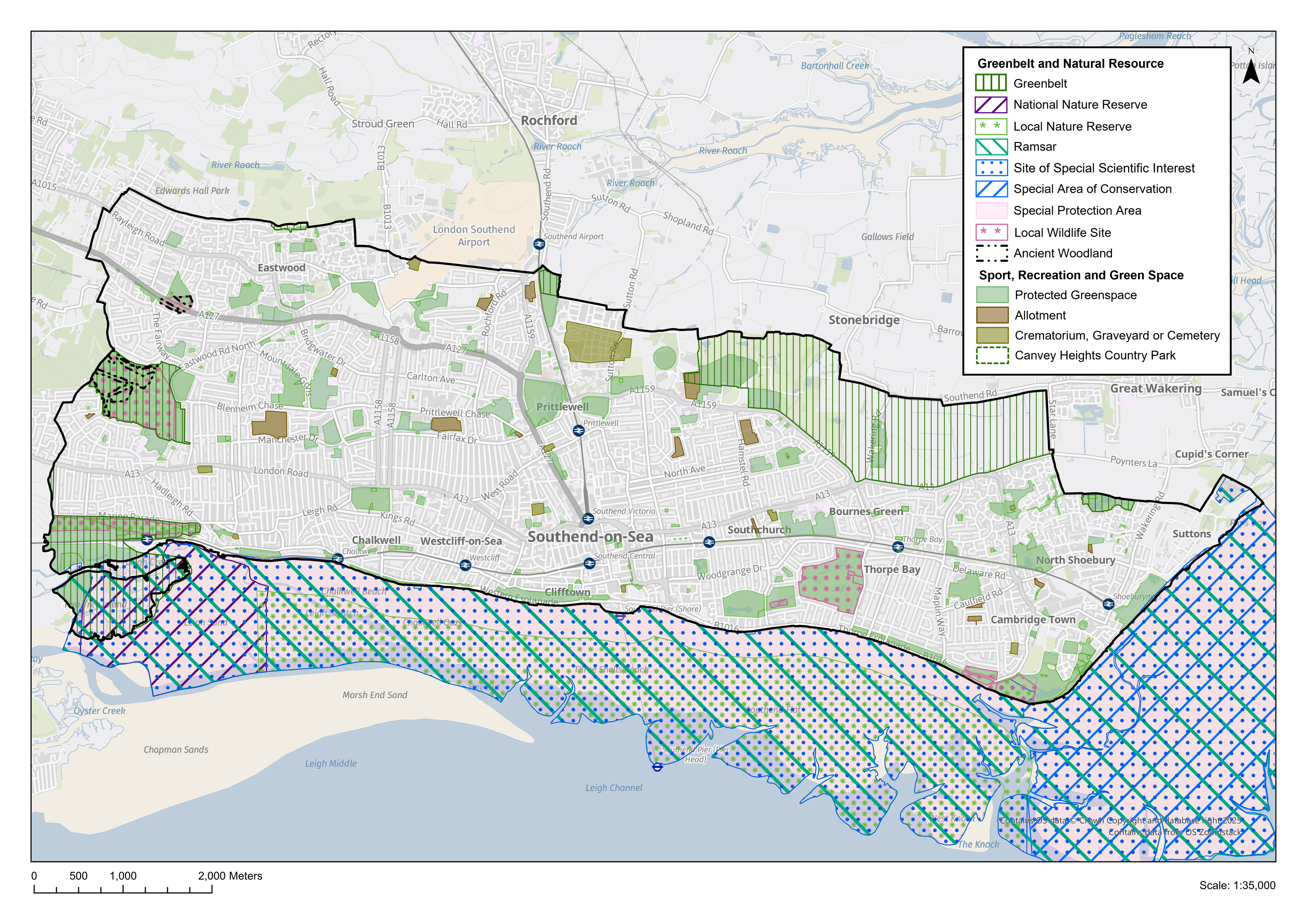
Why we have taken this approach
8.1 Policy SP8 sets out the Council's strategic priorities for protecting and enhancing the green infrastructure network and Green Belt around Southend. The policy seeks to protect green and blue spaces and create multi-functional green infrastructure with spaces for nature, recreation and social interaction. Better connections between Southend's different parks and open spaces will be created to promote active travel through walking and cycling, linked to the priorities in the Local Walking and Cycling Strategy. Where there are gaps in access to green space, these are described in the relevant neighbourhood section and opportunity areas identified. Each neighbourhood contains at least one park or open space of 7 hectares or greater in area which provides a variety of facilities, often with a visitor catchment beyond the local area, for example Priory Park, Chalkwell Park or East Beach.
8.2 Blue spaces also form part of the Green Infrastructure network in Southend, which includes waterbodies, ponds, estuaries, the coast and the sea. Within Southend the seven miles of foreshore provide an important recreational resource for residents and visitors. The King Charles III England Coast Path long distance trail route extends the length of the Southend foreshore and provides access to the coast as a natural resource, as well as a national Sustrans cycle route.
8.3 Policy DM8.2 designates land within Southend as Protected Green Space as identified on the Policies Map. This designation comprises a range of different land uses and types of green space, including (list not exhaustive):
- Neighbourhood Parks – parks of at least 7 hectares in size containing facilities such as cafes, fishing lakes, play space and sports courts and toilets, serving a neighbourhood and city-wide need;
- Local Parks and amenity space – smaller parks and areas of informal green space of at least 0.4 hectares, serving a local need, often with fewer or no facilities;
- Green Corridors – active travel routes with extensive green landscaping that also act as an ecological network e.g. Prittle Brook, Victory Path;
- Natural and semi-natural green space – areas with nature conservation value.
8.4 Southend does not have any large "district natural green space" 100 hectares or greater or "sub-regional greenspace" 500 hectares or greater. However, Country Parks at Hadleigh in Castle Point Borough Council and Cherry Orchard in Rochford District Council currently provide this function for Southend residents.
8.5 A new country park to the north of Southend, and potentially extending into Rochford, is proposed as part of the SEEPark concept jointly developed by the South Essex local authorities, furthering a long-held ambition set out in the Core Strategy (2007) to create a major new green space for Southend's residents in this part of the cityhttps://www.southessex.org.uk/news/more-than-a-park-vision-for-south-essex-estuary-see-park-announced. This would better connect the urban area of Southend with the rural fringes of the Roach Estuary by linking up existing rights of way and providing greater public access to green space, forming part of the wider sub-regional SEEPark. This may also provide an opportunity for additional burial space as part of the wider green infrastructure network, to meet Southend's needs for the plan period and beyond (see Policy DM4.1).
8.6 The Local Plan Refining the Options consultation (2021) sought views on whether a number of the most significant green spaces should be designated as Local Green Space in accordance with NPPF paragraph 107, which sets the qualifying criteria. Whilst this suggestion did receive some support in the consultation, there were also indications that having a two-tier policy approach to green space would lead to confusion about the purpose and status of green spaces without the benefit of the designation. Consequently, it is not intended to take this policy approach forward in Southend's Local Plan, which will continue to apply the "Protected Green Space" designation.
8.7 Southend contains several roads with a wide grassed central reservation within the highway, including Highlands Boulevard, Southchurch Boulevard and Thorpe Hall Avenue. These often include large mature trees, and provide a valuable amenity resource for residents, making a significant contribution to the city's tree canopy. The dual function of these roads as highway and ecological resource will continue to be promoted and their strategic importance as part of the city's green grid recognised.
8.8 Some areas of existing green space have potential to be released for other land uses, ensuring that any development would secure a net gain in biodiversity and include an element of improved quality green space. These include Elm Road (reference HEA137) and George Street (reference HEA135) in Shoeburyness. These sites are set out in the relevant site allocation tables in the neighbourhood chapter 12. Where these sites are proposed for development, some public open space will form part of the overall scheme.
8.9 Overall there will be a net gain of 19 hectares of land designated as protected green space on the policies map, compared with the current adopted Local Plan.
Have your say…
Please explain your answers
QSP8: Do you agree with draft Strategic Policy SP8: Enhancing our Natural Environment? Please explain your answer.
The Metropolitan Green Belt – development management policy
Reference to Strategic Objective and Strategic Policies
Strategic Objective 16
Why we need this Policy
8.10 The majority of open countryside and woodland surrounding Southend is designated as forming part of the wider Metropolitan Green Belt stretching north as far as the southern outskirts of the urban area of Chelmsford and westwards to the edge of London.
8.11 Land within Southend was first designated as forming part of the Metropolitan Green Belt in the early 1980's as part of the Essex County Council Interim Green Belt. These principles were incorporated into the adopted Essex Structure Plan in the early 1990's and detailed boundaries delineated and established in the adopted Southend on Sea Borough Local Plan (March 1994). The Green Belt designation has checked the unrestricted growth of London and prevented the coalescence of towns and cities in South Essex.
8.12 The Government attaches great importance to Green Belts. The fundamental aim of Green Belt policy is to prevent urban sprawl by keeping land permanently open, the essential characteristics of Green Belts are their openness and their permanence (NPPF paragraph 142). The Green Belt serves five purposes:
a) to check the unrestricted sprawl of large built-up areas;
b) to prevent neighbouring towns merging into one another;
c) to assist in safeguarding the countryside from encroachment;
d) to preserve the setting and special character of historic towns; and
e) to assist in urban regeneration, by encouraging the recycling of derelict and other urban land (NPPF paragraph 143).
8.13 There are eight parcels of land within the Southend administrative area which are currently designated as forming part of the Metropolitan Green Belt totalling just over 580 hectares of land (see Figure DM8.1). These are:
Western periphery of city
- land at Belton Hills/Two Tree Island west of Leigh on Sea;
- land west of Tattersall Gardens, Leigh on Sea;
- land at Belfairs Woods;
Northern periphery of city
- land at Green Lane, Eastwood;
- land at Warners Park;
- land north of Eastern Avenue;
- land to the north of Southend (Royal Artillery Way/Bournes Green Chase); and
- land at Friars Park, Shoeburyness.
Figure DM8.1: Green Belt within the Administrative Area of Southend
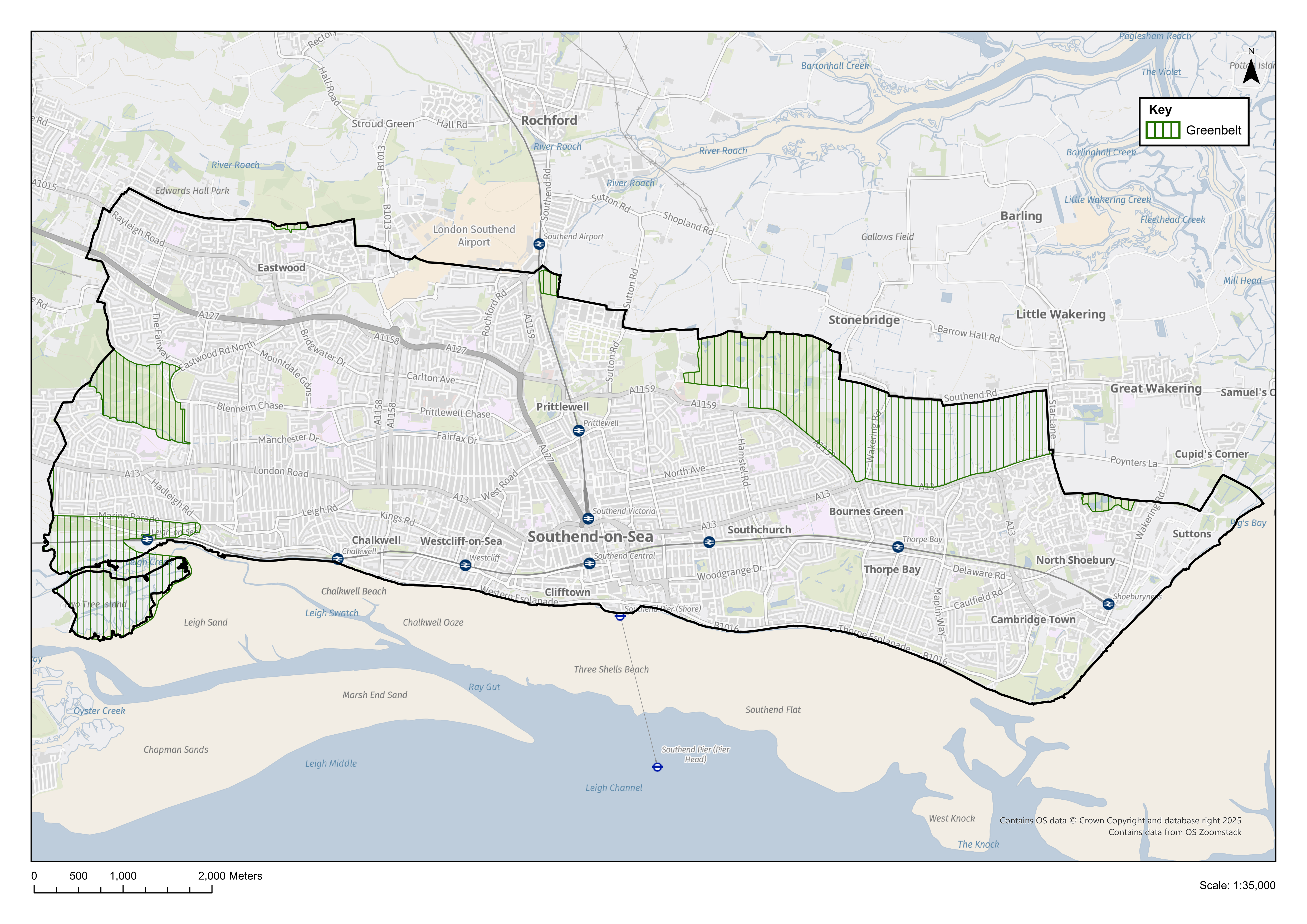
8.14 These areas of green belt are predominantly small parcels of land and/or land protected by nature conservation designations. The exception is an extensive area of land to the north of Southend (Royal Artillery Way/Bournes Green Chase) which is predominantly in agricultural use. This area has been the subject of representations from landowners and agents as part of the preparation of the Southend New Local Plan who are seeking to develop the land to provide a new neighbourhood to the north of Southend with a mix of uses, including housing and associated services, transport connections, infrastructure and new parkland. This could potentially incorporate additional green belt land to the north of the site situated within the neighbouring Rochford District to create a large development. If the option of a new neighbourhood was taken forward in the next stage of the Local Plan, then this would result in the de-designation of Green Belt in this area (Please provide comments concerning this within section 3b).
8.15 The other exception is a small pocket of land north of Eastern Avenue (17.2 hectares) that is identified in the Southend on Sea Borough Local Plan (1994) as being designated as Green Belt but which is separated from the wider Metropolitan Green Belt by other designated land allocations .This isolated tract of green belt land is as a result of a legal challenge to the Borough Local Plan in the mid 1990's in relation to land at Fossetts Farm on the northern periphery of the city. The Borough Local Plan originally designated land at Fossetts Farm and Eastern Avenue as forming part of the wider Metropolitan Green Belt. However, following the submission of a legal challenge by the landowner, the proposed land designations at Fossetts Farm were quashed in the High Court.
8.16 As a result, Southend on Sea Borough Council sought to re-establish the Council's original intention to designate the land at Fossetts Farm as forming part of the wider Metropolitan Green Belt in the publication of the 'Southend on Sea Borough Local Plan Second Alteration'. However, following a public inquiry, the Inspector recommended that land at Fossetts Farm should be designated as 'Safeguarded Land' outside the green belt for future development needs. The Southend on Sea Borough Local Plan Second Alteration was adopted in 1997 and in accordance with the Inspectors recommendations, land at Fossetts Farm was designated as 'Safeguarded Land'. This situation resulted in a small parcel of land to the south of Fossetts Farm and north of Eastern Avenue, identified as green belt land in the original Southend on Sea Borough Local Plan, being isolated from the wider Metropolitan Green Belt.
8.17 Given the isolation of land north of Eastern Avenue from the wider Metropolitan Green Belt, not surprisingly the green belt studyRochford District and Southend on Sea Joint Green Belt Study, LUC, London, February 2020 identified that the land made a weak contribution to the stated purposes of the green belt. To rectify this anomaly, it is proposed to delete the current isolated green belt designation at Eastern Avenue from the emerging Southend New Local Plan. There are also a small number of very minor amendments to the Green Belt boundary to take account of identified anomalies.
How the Policy Works
8.18 Inappropriate development is by definition harmful to the Green Belt and should not be approved except in very special circumstances. When considering any planning application, the Council will seek to ensure that new buildings in the Green Belt are strictly controlled in accordance with draft Policy DM8.1 and national planning policy. The NPPF outlines the types of development that are not inappropriate, and this includes agriculture or forestry buildings and recreational uses. In addition, the Council acknowledges that in certain cases it will be appropriate to permit infill development within the green belt within existing settlements and to allow for the replacement of existing buildings provided they are permanent and not materially larger than the one it replaces.
Policy DM8.1: The Metropolitan Green Belt
- Within the Green Belt inappropriate development will not be permitted except in very special circumstances.
- Planning permission will be granted for the following exceptions provided such development preserves the openness of the Green Belt, does not conflict with its stated purposes and does not detract from the existing character or appearance of the area, namely:
- buildings for agriculture and forestry;
- facilities for outdoor sport, outdoor recreation and cemeteries;
- minor extensions or alterations to existing buildings;
- infilling within an existing settlement where the site is a small gap in an otherwise built-up frontage and the infilling is limited so as not to impact unacceptably on the function and purpose of the Green belt; and
- replacement buildings where the existing building being replaced is of permanent and substantial construction and the new building is:
- in the same use as the existing; and
- not materially larger than the one it replaces.
Have your say…
Please explain your answers
Q8.1: Do you agree with draft Development Management Policy DM8.1: The Metropolitan Green Belt? Please explain your answer.
Green Infrastructure Network – development management policy
Reference to Strategic Objective and Strategic Policies
Strategic Objective 16
Strategic Objective 17
Why we need this Policy
8.19 The NPPF recognises the wider benefits from natural capital and ecosystem services and the importance of green infrastructure in achieving sustainable development and influencing determinants of health and wellbeing. Green infrastructureThe definition of Green Infrastructure includes blue infrastructure including the sea, rivers and lakes. (GI) provides a range of environmental, social and economic benefits. Provision of accessible green infrastructure including amenity and play space, 'play on the way' spaces that provide informal opportunities for play on green routes, local growing sites and safe routes for walking and cycling can encourage regular physical activity, improve community cohesion and mental health and wellbeing.
8.20 The city's GI network also plays a vital role in climate change mitigation and adaptation. Open space, trees, soft landscaping such as green walls and roofs, and water features can reduce the urban heat island effect making the built environment more comfortable during the summer months. It also provides shade, reduces air pollution and allows surface water and carbon to be stored increasing biodiversity and contributing to making places more attractive for visitors and investors.
How the Policy Works
8.21 Policy DM8.2 requires development proposals to protect existing green infrastructure, including public open space and address quantitative and qualitative deficiencies where development opportunities arise. The key areas of focus for new and enhanced green infrastructure are the City Centre and adjacent neighbourhoods, which lack sufficient local green space within walking distance of homesSouthend and Rochford Settlement Role and Hierarchy Study 2020 Southend Central Area Profile, and the opportunity for a new country park. This would be a landscape-scale green space created to serve new and existing residents.
8.22 Major development proposals should include a Green Infrastructure plan (which may be part of a Design and Access Statement) setting out how the development will deliver the GI policies, proposals and development requirements in development plan policies and local design codes. GI delivered in major developments should be managed, maintained, and monitored for a minimum of 30 years. Green Infrastructure elements of proposals should be multi-functional, for example providing public open space while meeting requirements for sustainable urban drainage and urban greening factor, providing co-benefits for people and for nature.
8.23 The Council will continue to invest in quality improvements to the main public parks and open spaces and seek to provide additional green infrastructure where resources are available, including through external funding and partnership with other public and private bodies. Priorities for GI investment will be set out in the Infrastructure Delivery Plan.
8.24 Relevant developments will be required to meet the statutory 10% biodiversity net gain (see Policy DM8.5).
Policy DM8.2: Green Infrastructure Network
- All major residential developments will be required to provide public open space. Provision should preferably be on-site, recognising in particular where the development would exacerbate existing deficiencies in quantity, quality and/or access. Where it can be robustly justified that on-site provision is not practicable a financial contribution will be sought for the provision of new/ improved public open space. Wherever new or improved green infrastructure is delivered as part of new development, the developer should make appropriate provision for its long-term management and maintenance.
- The loss of public open space through new development will not be permitted unless it would result in a replacement open space of equivalent or better quality and quantity being provided that would serve the same locality.
- Opportunities to provide new green space, play space and play on the way elements, local food growing and enhanced walking and cycling access are strongly encouraged, particularly where this would address deficiencies in quantity, quality and/or access.
- Developments should promote the conservation, restoration and enhancement of priority habitats, ecological networks and the protection and recovery of priority species. All proposals will be expected to contribute to biodiversity and meet the objectives of the Essex Nature Recovery Strategy.
- The redevelopment of existing allotment sites for other uses will only be permitted where it can clearly be shown that the facility is no longer required or can be adequately and conveniently provided elsewhere.
- Facilities for informal countryside recreation which increase public access will be encouraged, provided this would not adversely affect land of nature conservation, landscape or archaeological importance. The Council will work with other local authorities, landowners, horse-riding and walking interests to create additional footpath and horse-riding opportunities within Southend and adjoining areas and will seek to incorporate such facilities within the definitive rights of way network.
- Development proposals should not prejudice the informal recreation value of footpaths and bridleways.
- The Council will seek to enhance public open space provision by:
- providing local areas for play within areas of deficiency as land and resources allow;
- working in partnership to enhance connections between public open spaces for increased biodiversity, active travel and climate change resilience;
- widening community access to school recreation facilities wherever possible for example through community use agreements;
- qualitative improvements to existing public open space.
Note: Southend has no Regional or Sub-Regional Parks as defined within the South Essex Green and Blue Infrastructure Studyhttps://localplan.southend.gov.uk/sites/localplan.southend/files/2021-08/South-Essex-Strategic-Green-and-Blue-Infrastructure-Study.pdf
Have your say…
Please explain your answers
Q8.2 Do you agree with draft Development Management Policy DM8.2: Green Infrastructure Network? Please explain your answer.
Urban Greening Factor – development management policy
Reference to Strategic Objective and Strategic Policies
Strategic Objective 16
Strategic Objective 17
Why we need this Policy
8.25 The Urban Greening Factor is a tool that evaluates the quantity and quality of urban greening provided by a development proposal. It aims to accelerate the greening of urban areas and results in well planned and high-quality interventions that add to a multi-functional green infrastructure network.
8.26 The central area of Southend, including the City Centre and Central Seafront will be the continued focus for civic, cultural and commercial activity, where a substantial proportion of planned residential growth in Southend to 2040 is expected to come forward. Aside from one or two notable examples such as Warrior Square and Prittlewell Square, the High Street and its environs is severely lacking in green infrastructure, and previous public engagement has confirmed that residents strongly support the need for urban greening to enhance the character of the City Centre and make it a more attractive and welcoming place.
8.27 Urban greening can also provide climate change resilience. The Southend Heat Stress Strategy (2022) found that parts of Southend, including the City Centre and adjacent neighbourhoods lack green and blue infrastructure, which results in a higher average day and nighttime temperatures. This can contribute to increased levels of surface water run-off, causing localised surface water flooding issues, and higher temperatures are a risk factor for the health of vulnerable residents, including children and older people.
8.28 Southend is a densely developed area with limited opportunities for new green space. However, there will be opportunities to create green space where new development is proposed, including enhanced public realm, as well as improving connections between green spaces through soft landscaping, tree planting, green roofs and walls, and better signage and way finding. Such small interventions can make a significant impact as part of the wider network and can also provide a means of enhancing biodiversity on urban and brownfield sites.
How the Policy Works
8.29 Policy DM8.3requires major developments to demonstrate how they have integrated urban greening into their proposals. The aim is to secure a measurable increase in green and blue infrastructure. Increasing the amount of permeable surface will aid surface water run-off, and reduce heat stress, as well as creating a more attractive place, with benefits for the environment, local residents, and local businesses.
8.30 The Urban Greening Factor (UGF) is a tool to evaluate the quantity and quality of urban greening and compares the amount of greening proposed against a target score. The Surface Cover Types and Factor Scores are set out in Appendix 9.
8.31 Different types of greening measures are categorised by surface types with a factor score assigned to reflect their relative quality. The UGF assigns a factor score to each surface type as a proxy for naturalness and functionality. Better quality surface types can achieve a higher UGF score without increasing the overall footprint of greening. As Southend has an urban character, a score of 0.4 for predominantly residential development, and 0.3 for predominantly commercial development is considered appropriate. This approach has been endorsed by Natural England, and the surface cover types are consistent with Natural England proposed weightingshttps://publications.naturalengland.org.uk/publication/5846537451339776. For mixed-use developments the land use class with the largest square meterage surface area can be used to determine the target score and if necessary, advice can be sought from the local planning authority.
8.32 A review of major developments granted planning permission indicates that a measurable increase in urban greening would be technically feasible with only minor adjustments to scheme design. The Urban Greening Factor tool can be used to inform pre-application discussions and highlight opportunities to increase green and blue infrastructure as an integral part of the proposals, providing wider environmental, social and economic benefits.
8.33Policy DM8.3 does not replace the requirement to achieve 10% BNG (or higher) on qualifying developments. Where a proposal may affect a designated site for Nature Conservation the proposal should comply with Policy DM8.4 and Policy DM8.5 to avoid or mitigate any effects on the biodiversity value of the site.
Policy DM8.3: Urban Greening Factor
- Proposals for major development* must apply an Urban Greening Factor (UGF) to provide a measurable increase in urban greening within the red line boundary of the planning application, in accordance with the surface cover types and factor scores set out in Appendix 9.
- Developments should meet a target UGF score of 0.4 for residential developments and 0.3 for commercial developments.
- Urban Greening Factor scores should be calculated as follows:
- assign each surface cover type within the red line boundary a score in accordance with Appendix 9;
- measure the area of each surface type in square metres;
- for each surface type multiply the area by the factor score e.g. 2 sqm of amenity grass land x 0.4 = 0.8;
- add the scores together for each surface type;
- divide the combined score by the total site area (square metres) to determine the UGF score for the proposal.
- Any areas unchanged by the proposal, e.g. retained grassed areas, should be included in the calculation. Where a surface cover type is not included in Appendix 9, the application should identify and use the nearest relevant factor score. Vertical surfaces such as green walls can be included but should not be added to the site's total area.
- Urban Greening Factor calculations should be submitted as a separate drawing including colour coding or other method to identify each surface type and their contribution to the overall UGF score, and a table showing the calculations.
*Major development is defined in the NPPF as: For housing, development where 10 or more home will be provided, or the site has an area of 0.5 hectares or more. For non-residential development, it means additional floorspace of 1,000sqm or more, or a site of 1 hectare or more, or as otherwise provided in the Town and Country Planning (Development Management Procedure) (England) Order 2015.
Policy DM8.3 aims to secure a measurable increase in urban greening as part of new developments. There are two options to apply the policy:
Option 1 – Policy DM8.3 applied city-wide for all major developments - This would provide a city-wide benefit of increased green infrastructure for Southend which is predominantly a dense urban area albeit with a more suburban leafy character at its western and eastern edges.
Option 2 – Policy DM8.3 targeted to apply to major developments within specific neighbourhoods (Westcliff, Southend Central and Southchurch) – to address the lack of green infrastructure in these locations. The evidence for the targeted policy is set out in the Heat Stress Strategy 2022.
Have your say…
Please explain your answers
Q8.3i Do you agree with draft Development Management Policy DM8.3: Urban Greening Factor? Please explain your answer.
Q8.3ii Where should the Urban Green Factor (Policy DM8.3) be targeted. For all major developments:
a) Option 1 – across the city; or
b) Option 2 - within specific areas that lack green infrastructure/spaces (namely the neighbourhoods of Westcliff, Southend Central and Southchurch)?
Southend Foreshore – development management policy
Reference to Strategic Objective and Strategic Policies
Strategic Objective 7
Strategic Objective 10
Strategic Objective 15
Strategic Objective 18
Why we need this Policy
8.34 Southend's residents benefit from their close relationship with the River Thames, and the seafront is a major tourism and leisure resource. The offer ranges from informal recreation along an extensive promenade, to major tourism attractions within the Central Seafront area, including the Grade II listed Pier, theme park, arcades, and cafes, while water sport activities are present along the length of the foreshore. The entire foreshore is also important as a habitat for bird species, with five internationally designated sites for nature conservation covering the intertidal part of the Thames Estuary. These sites support a wide range of bird species, providing overwintering feeding grounds.
8.35 As such, the complex range of activities taking place within and adjacent to the foreshore must be considered in a holistic manner to ensure that environmental and heritage assets are protected without adverse impact on their purpose and integrity.
8.36 By 2050 there is likely to be 59% more winter rainfall and once a century sea level events could become annual events by 2100.Thames Estuary 2100 (TE2100) - GOV.UK Significant lengths of the seafront and adjacent homes and business premises are protected from tidal flooding by sea defences. The Central Seafront area in particular includes areas at higher risk of surface water flooding when periods of heavy rainfall coincide with high tides and where gravity discharge to tide via drainage outfalls is constrained or tide-locked. The 'riverside strategy' approach advocated by the Environment Agency aims for upgrades of coastal defences to be integrated into wider development and enhancement of the riverside.
8.37 The National Flood and Coastal Erosion Risk Management Strategy for England (2020)https://www.gov.uk/government/publications/national-flood-and-coastal-erosion-risk-management-strategy-for-england--2 aims to better manage the risks and consequences of flooding from rivers, the sea, groundwater, reservoirs, ordinary watercourses, surface water and sewers and coastal erosion and making greater use of nature-based solutions that take a catchment-based approach to both floods and droughts. The Southend-on-Sea Shoreline Management Plan (2019) provides a strategy for the next 100 years, to maximise the reduction of coastal flood and erosion risk to properties and infrastructure at significant or very significant risk of flooding as a result of climate change, in support of the Essex and Suffolk Shoreline Management Plan (2010) and Thames Estuary 2100 Plan (TE2100) (2012) and subsequent reviews.
8.38 The c2c line runs between Hadleigh and Leigh through Hadleigh Marshes, through an area at risk of tidal flooding. The TE2100 Plan's preferred tidal flood risk management policy for the Hadleigh Marshes policy unit is to maintain flood defences at their current level, accepting that the flood risk will increase. The Council will seek to ensure, in collaboration with Network Rail, railway operators (currently C2C), the Environment Agency and other partners, the continued resilience of this vital transport route during the plan period and beyond, taking into account the long-term impacts of climate change. The TE2100 Plan's preferred tidal flood risk management policy for the Leigh Old Town to Southend-on-Sea policy unit is to take further action to keep up with climate and land use change so that flood risk does not increase. Southend-on-Sea City Council will work with the Environment Agency and other partners to implement the capital works required.
8.39 The Council is not responsible for planning beyond the coastal mean low water mark. However, all developments providing sea-based activities (such as jet skiing, surfing, or boat facilities) or with a potential impact on the marine environment, including above mean high-water springs should take account of the South East Marine Plan, in line with the principles of integrated coastal zone management.South East Inshore Marine Plan (June 2021) https://assets.publishing.service.gov.uk/media/60f6f6dde90e0764ccfbd836/FINAL_South_East_Marine_Plan__1_.pdf
8.40 Water recreation has increased in popularity in Southend, particularly since the covid-19 pandemic, and the Estuary is used by local groups and individuals and visitors for a variety of water sports all year round, including yachting, windsurfing, stand-up paddle boarding, swimming, and jet-skis. There is also a segregated cycle path along most of the seafront (with shared space in some of the busiest sections), and the England Coast Path, a signed walking route along the foreshore providing almost continuous public access along the coastline.
8.41 The historic environment plays an important role in the development and continued success of Southend as a coastal destination, beginning with the establishment of Royal Terrace in the Georgian period, and improved access by rail for day trips during the 19th Century to visit the seafront, amusements, and the Grade II listed Pier. There are several Conservation Areas (CAs) adjacent to the 7-mile length of the seafront from the working port at Leigh Old Town CA to the former military Shoebury Garrison CA, each with their own unique character.
8.42 The continued regeneration and sustainable development of Southend's foreshore is a key objective of the Local Plan (Strategic Objective 10), including making more effective connections between Southend High Street and the seafront. The Council's tourism and cultural strategies also seek to promote other parts of the seafront, including East Beach and Old Leigh as visitor destinations, as well as the Central Seafront area. Leigh Port is an active fishing port and centre for maritime activities, and supports the tourism, retail and hospitality sectors. It remains an ambition to enhance the condition of the Cinder Path between Old Leigh and Chalkwell Station, part of the Sustrans National Cycle Network and more recently the England Coast Path, as a route for pedestrians and cyclists (see also Policy N2: Leigh Neighbourhood).
8.43 The cumulative (or "in combination") impact of growth is being addressed through the Essex Coast RAMS partnership, to alleviate pressure on designated habitats. New housing in the area is likely to increase the level of disturbance because of the additional visitor pressure on coastal sites. Developers will therefore need to pay a tariff if their new development is within a 'Zone of Influence' around a designated site. The Essex Coast RAMS Supplementary Planning Documentwww.southend.gov.uk/local-planning-framework/essex-coast-rams sets out the justification for the tariff and the range of mitigation measures that will be taken.
8.44 Some housing schemes, particularly those which are large in scale or located close to a designated Habitats site boundary, may need to provide extra bespoke mitigation. The local planning authority, with advice from Natural England, will consider the mitigation requirements for such development proposals on a case-by-case basis.
How the Policy Works
8.45 Proposals that may affect the foreshore area should be in accordance with the provisions of Policy DM8.4, taking account of the complex range of factors affecting the coastline and its use.
8.46 The TE2100 Planwww.gov.uk/government/collections/thames-estuary-2100-te2100 advocates a 'Riverside Strategy' approach which emphasises the importance of partnership working on development and coastal management, to achieve multiple benefits for the environment and for people. This is particularly important in Southend where an appropriate balance must be struck between protecting environmental assets and achieving coastal resilience, and the tourism role of the coast as an economic driver. The Riverside Strategy will be produced for Southend in support of Policy DM8.3 which will provide clear guidance for any development affecting the Foreshore. Development proposals within areas at risk of flooding must take account of the most up to date Strategic Flood Risk Assessment with reference to Policy DM9.4.
8.47 The historic character of the seafront will be conserved and enhanced. New development should be appropriate to local character and context, in accordance with the seafront character zones set out in Policy Table DM8.4 (and as defined on the Policies Map).
8.48 Applications where RAMS applies will be refused if a RAMS mitigation payment has not been paid or secured as part of a legal agreement. Applicants can also provide mitigation themselves, but they will need to show the Council and Natural England that their proposed measures will fully safeguard the habitat from the impact of their development.
Policy DM8.4: Southend Foreshore
- Proposals for development should maintain and improve the integrity of designated habitats of International, European and national importance, and limit any adverse impacts on the biodiversity interests of the local nature reserves and coastal and marine environment. Individual proposals affecting the foreshore are likely to require assessment under the Habitats Regulations 2017 to ensure screening for potential adverse impacts on internationally designated nature conservation sites in the area.
- Development which may affect the UK Marine Area should take account of the South East Marine Plan in assessing the potential impacts on the marine environment. Proposals should demonstrate that they would be resilient to the impacts of flood risk, climate change and coastal change for the lifetime of the project. Proposals that are likely to have significant adverse effects on coastal change will not be supported.
- Development within or near to Southend Foreshore must not detrimentally impact upon the Thames Estuary's openness or views across and backdrops to the River Thames and Southend's beaches.
- Development proposals should take account of Strategic Flood Risk Assessments and Surface Water Management Plans to avoid and mitigate flood risk and be flood resistant and resilient. Proposals should not prevent or restrict future maintenance and improvement of flood defences and the ability to manage coastal change. Coastal defences should be renewed and/or replaced in accordance with the priorities set out in the Shoreline Management Strategy and successor documents, including consideration for raising fixed defences in the future where required.
- Proposals for development which enhance habitats providing flood defence or carbon sequestration are supported, where they integrate nature-based solutions for sustainable drainage and landscaping and demonstrate how they contribute to and enhance the city's green and blue infrastructure network, as set out in Policy DM8.2.
- Proposals for development that supports Southend-on-Sea as a thriving coastal resort will generally be supported where:
- development would not detrimentally reduce the amount of beach available for public use or public accessibility to the foreshore; and
- where development would provide an inclusive means of access to the foreshore and would contribute to the positive appreciation of natural resources and biodiversity of the foreshore;
- refurbishment and replacement of beach huts will only be permitted on a like for like basis to maintain the uniformity of height, footprint and building line and avoid any significant change in scale or character.
Proposals for new and improved facilities, including additional slipways may be provided in appropriate locations where they do not conflict with other beach activities, public accessibility, the general enjoyment of the foreshore and the natural environment, including designated habitat sites.
- Existing buildings along the Seafront that form a cohesive frontage, have an historic context or are recognised as key landmarks and/ or contribute to a distinctive Southend sense of place will be retained and protected from development that would adversely affect, their character, setting and the importance of the Seafront, in accordance with the Seafront Character Zones set out in Policy Table DM8.4 (and as defined on the Policies Map). Proposals should take account of any known wreck sites or other heritage assets that may be affected.
- Where appropriate, contributions from new residential developments will be secured towards measures identified in the Essex Recreational disturbance Avoidance and Mitigation Strategy (RAMS) to mitigate in-combination effects on designated habitat sites. Where a development is likely to have a significant impact on designated habitats by themselves, bespoke mitigation may be required.
- New residential development, particularly close to designated habitat site boundaries or major development, may be required to provide project level mitigation to safeguard designated habitats from potential impacts
Policy Table DM8.4: Seafront Character Zones (defined on the Policies Map)
|
Have your say…
Please explain your answers
Q8.4: Do you agree with draft Development Management Policy DM8.4: Southend Foreshore? Please explain your answer.
Biodiversity and Net Gain – development management policy
Reference to Strategic Objective and Strategic Policies
Strategic Objective 4
Strategic Objective 16
Strategic Objective 17
Why we need this Policy
8.49 The UK has lost almost half its biodiversity since the 1970s,www.nhm.ac.uk/discover/news/2019/october/the-state-of-nature-41-percent-of-the-uks-species-have-declined.html and sits near the bottom of the Biodiversity Intactness Index. It is the lowest of any G7 nationwww.nhm.ac.uk/discover/news/2020/september/uk-has-led-the-world-in-destroying-the-natural-environment.html and in the bottom 10% of all countries globally, with only 50.3% of its biodiversity remaining. Southend is densely urbanised, and land and buildings make up approximately 42% of the entire city (this includes private gardens and the intertidal area). Quantitative evidence about loss of natural habitat in Essex is hindered by a lack of systematic data collectionEssex Biodiversity Net Gain – Evidence for Need (ECC Place Services) (2024).
8.50 The Environment Act (2021) introduced a mandatory requirement for at least 10% biodiversity net gain (BNG) to be achieved for qualifying developments which require planning permission. BNG aims to create new habitat as well as enhancing existing habitat where new development occurs, to leave biodiversity in a measurably better state than before the development took place. It can help mitigate climate change using "nature-based solutionsNature Based Solutions can include protection, restoration or management of natural and semi-natural ecosystems and the integration of nature in and around cities. www.naturebasedsolutionsinitiative.org/what-are-nature-based-solutions" to address wider environmental problems such as flooding, water quality and reducing carbon emissions, and achieve greater resilience to extremes of weather including heatwaves and flooding. Increased biodiversity can also contribute towards place-making, creating greener neighbourhoods that are more attractive to live, work and do business and enhance health and wellbeing.
8.51 Biodiversity net gain will support the delivery of the Essex Local Nature Recovery StrategyDraft Essex Local Nature Recovery Strategy, contributing to the formation of the England-wide Nature Recovery Network, a national network of wildlife rich places to increase and restore nature. Southend's Biodiversity Action Plan 2013www.southend.gov.uk/downloads/file/3557/local-biodiversity-action-plan-report-2013 identifies the priority species and habitats for protection and enhancement.
How the Policy Works
8.52 In England, biodiversity net gain is required under a statutory framework.www.legislation.gov.uk/ukpga/2021/30/schedule/14/enacted Qualifying developments will be deemed to have been granted planning permission subject to the condition that the biodiversity gain objective is met ("the biodiversity net gain condition"). Some exceptions apply, including for householder development, permitted development and self-build/custom build. Applicants are advised to check the Planning Practice Guidancewww.gov.uk/guidance/biodiversity-net-gain for more information.
8.53 The focus for biodiversity gains in Southend is to protect and enhance the city's existing green infrastructure network and create opportunities to better connect individual parks and open spaces with green corridors to create an enhanced biodiversity network.
8.54 To achieve biodiversity net gain, applicants are expected to:
- Use the latest available DEFRA Biodiversity MetricBiodiversity Metric www.gov.uk/guidance/biodiversity-metric-calculate-the-biodiversity-net-gain-of-a-project-or-development to assess the biodiversity value of the site, and identify relevant assets;
- Determine the impact of development options on the biodiversity value of the site, using the Mitigation Hierarchy;
- Establish a design solution that delivers the greatest biodiversity net gain and enhances the ecological network;
- Submit detailed solutions that demonstrate how Biodiversity Net Gain would be delivered.
8.55 The requirements for biodiversity net gain will apply to development projects, or components of projects, as far as the low-water mark, including the intertidal zone. Projects, or components of projects, in the marine environment beyond the intertidal zone are not included within the scope of the mandatory requirements for biodiversity net gain. Protected species, protected sites and irreplaceable habitats will be dealt with in accordance with relevant legislation and licensing regimes, but they must also be taken into account as part of wider biodiversity considerations. The mandatory biodiversity net gain process is additional to existing requirements for Environmental Impact Assessment, Strategic Environmental Assessment, and Habitat Regulations Assessment. There are opportunities to align reporting so that efforts are not duplicated.
8.56 The biodiversity gain condition is a pre-commencement condition: once planning permission has been granted, a biodiversity gain plan must be submitted and approved by the Council before commencement of development. Submission of a draft biodiversity gain plan with the planning application, whilst not legally required, will assist in demonstrating prior to consent where and how the measures will be implemented and secured. The biodiversity gain plan must include the minimum national information requirementsPlanning Practice Guidance, Biodiversity Net Gain (paragraph 011) www.gov.uk/guidance/biodiversity-net-gain#para11.
8.57 When evaluating biodiversity gain plans the Council will be seeking to ensure that proposals have applied the Mitigation Hierarchy and provides good outcomes for nature, not just achievement of the percentage BNG. Proposals will also need to demonstrate that they provide a long-term benefit to biodiversity that is compatible with other site uses such as recreational space or sports pitches. Proposals should be informed by the Essex Local Nature Recovery Strategy and any Southend specific biodiversity evidence.
8.58 Where off-site habitat measures are required, applicants must provide UK habitat assessment surveys to agree a baseline metric of the existing offsite habitats, conform to BNG CIEEM/IEMA/CIRIA- Good Practice Principles for Development and seek to deliver strategic BNG as close as feasible to the impacts of the development. The Defra Biodiversity Metric trading rules should also be observed.
8.59 The Council will provide further detailed guidance on BNG setting out any local requirements for on-site and offsite habitat enhancement or creation as well as application of the Biodiversity Gain Hierarchy, including information required at validation, long-term management and monitoring options, funding arrangements, legal arrangements, and costs for any local or strategic offsetting schemes.
Policy DM8.5: Biodiversity and Net Gain
- Proposals for qualifying developments* must deliver an overall net gain of at least 10% for biodiversity using the DEFRA biodiversity metric, and:
- applicants must use the DEFRA metric or other agreed equivalent to establish the baseline and proposed post-development biodiversity value of the development site, including any off-site areas proposed for habitat creation;
- assessment should be undertaken by a suitably qualified person**;
- the assessment should be submitted in a digital format alongside the planning application, including a draft Biodiversity Gain Plan;
- the development proposed should accord with the Mitigation Hierarchy, by firstly avoiding harm to biodiversity; then looking to provide on-site mitigation, followed by off-site mitigation. The purchase of biodiversity credits toward habitat banks should only be proposed as a last resort;
- any off-site habitats proposed to be created or enhanced should optimise local nature recovery including connection with a network of sites for biodiversity;
- a draft Habitat Management and Monitoring Plan should be submitted with the planning application, indicating how the biodiversity net gain will be achieved and maintained over this period.
*For qualifying developments please refer to The Biodiversity Gain (Town and Country Planning) (Modifications and Amendments) (England) Regulations 2024 or successor requirements www.legislation.gov.uk/uksi/2024/50/contents/made
** If the small sites metric is used, the assessment must be undertaken by a competent person. If the full metric is used, the assessment must be undertaken by a qualified CIEEM ecologist.
Have your say…
Please explain your answers
Q8.5: Do you agree with draft Development Management Policy DM8.5: Biodiversity and Net Gain? Please explain your answer.
Trees – development management policy
Reference to Strategic Objective and Strategic Policies
Strategic Objective 17
Why we need this Policy
8.60 Individual trees form a network that makes an essential and positive contribution to the city's green infrastructure. There are approximately 30,000 trees within the Council's highways, parks and gardens, and more are located on private land including residential gardens. In October 2019 the canopy cover of the entire city was measured at 12%, below the UK average of 17% and slightly lower than the average canopy cover of coastal towns at 13.7%. The Woodland Trust also provide a Tree Equity Score UK Map which takes into account a range of six equally weighted climate, health and socio-economic variables to identify priorities for tree planting to contribute towards achieving Tree Equity.
8.61 Tree coverage varies significantly across the city, from a high of 23.3% in Belfairs Ward, to just 8.5% in Westborough Ward. This reflects the extensive woodland in Belfairs Woods and Golf Course compared with the very urban nature of wards such as Westborough where hard surfaces are the predominant ground material (see Figure DM8.6).
8.62 Trees provide significant benefits for our physical and mental health and wellbeing by providing a sense of place and access to nature, for biodiversity, provision of shade and cooling, and help to alleviate surface water flooding by offsetting heavy rainfall.
8.63 The Council's Tree Policy sets a target to increase the tree canopy in the city from 12% to 15% by 2030. This is equivalent to a 20% increase in tree canopy cover in Southend and would cover an area the size of 150 football pitches. It is an ambitious target for the city which will be achieved by the Council acting in partnership with local businesses, community groups and residents.
8.64 Many of the existing stock of trees within the city were planted during the peak growth of the settlement, from the late 19th century to the post war growth of the 1950s. Careful management of the existing stock and careful selection of appropriate species for each location will be necessary to achieve the desired increase in canopy cover.
How the Policy Works
8.65 Policy DM8.6 seeks to protect the existing stock of trees within the city and increase the tree canopy cover as opportunities arise through new developments. Developers should set out proposals to plan, plant, and manage trees within new developments, and agree how they will be funded, including through developer contributions and other mechanisms such as Biodiversity Net Gain.
8.66 Existing trees on site should be protected and retained wherever possible, with any losses compensated using the CAVATwww.ltoa.org.uk/resources/cavat methodology. This provides a capital asset value for amenity trees which reflects their value as essential natural capital. Of particular note for the Southend context, the CAVAT methodology (amongst several other factors) assigns a greater weighting to trees within areas of greater population density, reflecting the size of the community that experiences benefits provided by the tree.
8.67 Trees may also be subject to a Tree Preservation Order and/ or be located within a Conservation Areawww.gov.uk/guidance/tree-preservation-orders-and-trees-in-conservation-areas which means that consent is usually required for works to such trees (including cutting down, topping, lopping or uprooting). Advice should be sought from the local planning authority to establish if consent is required. When granting planning permission, the Council may also where appropriate, use planning conditions to provide for tree retention and planting.
8.68 New streets should be tree lined, in accordance with the expectations of the NPPF. Major residential and non-residential development should be designed to contribute towards the tree canopy cover target.
8.69 The right tree should be planted in the right place. Where trees are proposed to be planted as part of a development proposal, advice should be sought from the Council's arboriculture officer to ensure that the species is appropriate for the site character and condition and taking account of future maintenance requirements, for example, tree age, height and root spread of future trees, and soil type. The impact of climate change on average temperatures and rainfall levels in the future will also inform the selection of tree species.
8.70 There are constraints to tree planting within built up areas, including underground services. Within new highway schemes or other hard landscaping projects, special planting techniques which allow adequate soil volume to be available and avoid tree roots damaging the hard surface should be used. http://www.tdag.org.uk/trees-in-hard-landscapes.html
8.71 Additional planting should be included wherever opportunities arise, using creative solutions including the provision of planters, green roofs and walls, rain gardens and other sustainable drainage measures as appropriate.
Further guidance is available in the National Model Design Code on how trees can be included in the built environment. www.gov.uk/government/publications/national-model-design-code
Policy DM8.6: Trees
- Tree planting should be incorporated as an integral part of new development schemes to help achieve the Council's city-wide target of 15% canopy cover. This includes the public realm as well as private gardens and commercial land. New streets should be tree lined. Tree planting will be prioritised in neighbourhoods with the lowest tree canopy cover.
- On-site trees should be retained wherever possible and are always preferable to off-site compensatory planting. Tree protection measures should be included in development proposals to show how existing trees will be safeguarded during construction. Proposals to remove on site trees should be accompanied by a Tree Survey which sets out the justification for removal. Planning conditions may be imposed to preserve trees on site or require additional planting. When trees are removed, they should be replaced on a least a 2:1 ratio.
- Where an individual tree or group of trees makes a significant contribution to the local streetscape and replacement trees cannot be accommodated on site, a planning obligation may be required to secure financial compensation and enable the local authority to plant new trees in the vicinity. Where development would result in the loss of a tree or group of trees, the CAVAT system* will be used to provide a value for the tree and enable compensation for damage or loss.
Have your say…
Please explain your answers
Q8.6: Do you agree with draft Development Management Policy DM8.6: Trees? Please explain your answer.
9. Climate Change, Sustainable Design and Environmental Protection
Strategic Policy
Where we are now
9.1 Human induced climate change over the last century has caused widespread adverse impacts to nature and people, beyond natural climate variability, and there is high confidence that beyond 2040, climate change will lead to numerous risks to human and natural systemsIPCC, Climate Change 2022: Impacts, Adaptation, Vulnerability www.ipcc.ch/report/ar6/wg2/.
The key issues to be addressed over the plan period and beyond are:
- Coastal, river and surface water flooding from high rainfall and rising sea levels will require a whole catchment approach to flood risk management;
- Continuing sea level rise is expected to require maintenance and renewal of coastal defences;
- Extreme rainfall events may lead to a reduction in water quality through release of pollutants;
- A growing population increases demand for water supply within an area of high water stress and water scarcity;
- Rising temperatures will increase heat stress particularly within high density areas lacking green infrastructure, with disproportionate impacts on vulnerable groups such as older people, and low-income households;
- Existing homes, non-domestic buildings and private transport are the primary sources of carbon emissions generated in SouthendCarbon emissions in Southend https://democracy.southend.gov.uk/documents/s54687/Report%20of%20Exec%20Director%20Neighbourhoods%20and%20Envt.pdf;
- Most of Southend is already built up so retaining the embodied carbon in existing buildings and re-using construction and demolition materials will reduce levels of waste and generate fewer additional carbon emissions from construction;In a Circular Economy, products and materials are kept in circulation, for example through processes such as maintenance, reuse, refurbishment, remanufacture, recycling and composting.
- Limited capacity for large scale wind or solar power generation, due to the densely built-up character of the city, and the environmental designations along the foreshore which protect internationally important bird species;
- Emissions from petrol and diesel vehicles impact on local air quality, particularly within the two air quality management areas.
Where we want to be
Strategic Objective 10
Strategic Objective 15
Strategic Objective 18
Supporting Documents
Key supporting documents that underpin the policies are available on the Council's Evidence Documents | Southend Local Planhttps://localplan.southend.gov.uk/evidence-documents, particular under the heading 'Planning for climate change'.
How we are going to get there
Strategic Policy SP9. Climate Change and Environmental Protection
- New development must ensure Southend is more resilient to the impacts of climate change, by mitigating and reducing carbon emissions from land use and building construction and adapting the environment where necessary to mitigate climate change impacts.
Climate Change Mitigation
- In order to reduce carbon emissions, new development must:
- Mitigate climate change in accordance with the following hierarchy:
- be lean: use less energy and manage demand during operation;
- be clean: exploit local energy resources (such as secondary heat) and supply energy efficiently and cleanly;
- be green: maximise opportunities for renewable energy by producing, storing and using renewable energy on-site;
- be seen: monitor, verify and report on energy performance;
- Support the principle of walkable neighbourhoods, enabling residents to access the full range of day-to-day facilities on foot, by bicycle or public transport;
- Promote a circular economy* through retention and/or re-use of materials;
- Improve walking and cycling connections to improve opportunities for active travel and reduce demand to travel by private car.
- Mitigate climate change in accordance with the following hierarchy:
Climate Change Adaptation
- The impacts of climate change on Southend will be addressed by:
- Managing flood risk, taking a whole catchment approach and including flood resistant and flood resilient measures (Policy DM9.4 flood risk policy and sustainable drainage);
- Ensuring sea defences are adequate to manage flood risk for the plan period and beyond, and safeguarding land for future replacement and/or raising of flood defences to ensure climate change adaptation is feasible;
- Careful management of water resources including water efficiency measures and nature-based sustainable drainage solutions;
- Opportunities to better adapt to heat stress by protecting and strengthening the green and blue infrastructure network.
Environmental Protection
- The city's natural resources and resident's health will be protected by:
- Safeguarding the existing minerals resources including brickearth and agricultural land;
- Avoiding harmful impacts on human health and the environment through water, air or soil pollution and land instability.
*where products and materials are kept in circulation, for example through processes such as maintenance, reuse, refurbishment, remanufacture, recycling and composting
What it will look like
Figure SP9: Climate Change and Environmental Protection

Why we have taken this approach
9.2 Planning must ensure that the development and use of land contributes to the mitigation and adaptation to climate change. Climate resilient development can significantly increase the adaptive capacity of places, providing multiple co-benefits for health and wellbeing and ecosystem services, such as reducing obesity, asthma and premature deaths due to pollution, protection of wildlife and enhancement of existing blue and green infrastructure assets. It also has benefits for the economy and social inclusion, such as security of energy supply through increased energy diversity, reduced fuel cost and employment possibilities.
9.3 Southend-on-Sea City Corporate Plan 2024-2028 highlights some of the environmental challenges Southend faces in the future, including an ageing built environment; environmental instability; the poor quality of our air; and risks of natural flooding and coastal erosion. The Plan's outcomes include to "build a resilient city to tackle effects of climate change." The Council will work with partners to improve water quality and make Southend a national exemplar for flood and coastal erosion risk management.
9.4 Southend needs to be able to adapt to a changing climate in the following ways:
- Our infrastructure will need to be maintained and renewed, and built to higher specifications where appropriate such as raising sea defences;
- Taking into account climate change projections for sea level rises and increased rainfall, we will need to review our flood zone mapping to ensure new development, particularly housing and other vulnerable uses (e.g. healthcare) that have to be located in areas of flood risk is resilient for the long term
- Increasing green and blue infrastructure coverage in areas of heat stress to reduce day and night ambient temperatures and health impacts on vulnerable groups;
- Supporting nature, creating resilient local habitats for our native species and supporting woodland creation and management for carbon sequestration;
- Creating new energy efficient and adaptable buildings for the 21st century by minimising carbon emissions and addressing the retrofitting challenge;
- Decarbonising the transport network and providing more opportunities for active travel;
- Reducing carbon emissions from waste and energy networks.
Have your say…
Please explain your answers
QSP9: Do you agree with draft Strategic Policy SP9: Climate Change and Environmental Protection? Please explain your answer.
Sustainable Design and Construction – development management policy
Reference to Strategic Objective and Strategic Policies
Strategic Objective 15
Why we need this Policy
Water efficiency
9.5 Essex is already classified as a seriously water-stressed areawww.gov.uk/government/publications/water-stressed-areas-2021-classification, and existing water resources need to be managed carefully. Essex is one of the driest places in the country, and by 2050, Essex may have a water shortage of almost 150 million litres every day, with climate change and population growth exacerbating water shortages, and impacts on the environment.
9.6 Looking ahead, our winters will continue to be a lot wetter and summers a lot drier. The Essex Water Strategywww.essex.gov.uk/news/2024/new-water-strategy-essex identifies three main ways to address the projected shortfall in water supply: reducing demand for water, changing land use for water, and developing new sources of water supply. Southend does not have the land resource to influence additional water supply, but through the Local Plan developments can make more space for water through nature-based solutions to sustainable drainage (Policy DM9.4) and urban greening measures (Policy DM9.3), and new developments can include water efficiency measures to reduce demand for mains water and increase domestic waste water recycling.
9.7 The average number of litres used daily per person in Essex households is 152.3 litres. Part G of the Building Regulationshttps://assets.publishing.service.gov.uk/media/5a80092540f0b623026911f3/BR_PDF_AD_G_2015_with_2016_amendments.pdf allows for local authorities to adopt an optional higher water efficiency standard per household of 110 litres per day in new dwellings, within in areas of high water stress. Southend adopted the optional higher standard of water efficiency in the Development Management DPD (2015), and this is being implemented in new developments. Policy DM9.1 requires residential development to incorporate water efficiency measures that limit internal water consumption per household to 110 litres per day (including external water consumption), maintaining the existing policy requirement.
Energy Efficiency
9.8 The Planning and Energy Act 2008 specifically allows the setting of energy efficiency standards that exceed the energy requirements of Building Regulations. Requirements should be 'reasonable'.
9.9 Approximately 90% of existing housing in Southend (and at least 30% of Council stock) is below Energy Performance Rating (EPC) C. To meet the government's net zero target by 2050, these properties will need some form of retrofitting to increase their energy efficiency and reduce carbon emissions from this sector. This means that new build homes should be as energy efficient as possible, avoiding expensive retrofitting once properties are built, and providing savings on heating bills for future residents.
9.10 The government is proposing to update Part L of the Building Regulations to achieve more energy efficient homes, to be known as the Future Homes and Buildings Standard (FHS). Its aim is to ensure that new homes built from 2025 will produce 75-80% less carbon emissions than homes built under the current Building Regulations. The government consulted on two options for implementing the FHS in December 2023The Future Homes and Building Standards: 2023 consultation www.gov.uk/government/consultations/the-future-homes-and-buildings-standards-2023-consultation and the new standard is intended to come into force from 2025.
9.11 The Essex Climate Action Commission commissioned evidence on behalf of all the Greater Essex local authorities to demonstrate that building to net zero in operation would be technically feasibleEssex Net Zero Policy Study www.essexdesignguide.co.uk/climate-change/essex-net-zero-policy-study/, financially viableNet Zero Carbon Viability and Toolkit Study, Essex Design Guide www.essexdesignguide.co.uk/climate-change/essex-net-zero-evidence/net-zero-carbon-viability-and-toolkit-study/ and legally justifiedEssex Open Legal Advice Energy Policy & Building Regulations, Essex Design Guide www.essexdesignguide.co.uk/climate-change/essex-open-legal-advice/essex-open-legal-advice-energy-policy-and-building-regulations/. A proposed "Local Standard" would use an Energy Use Intensity (EUI) metric that would measure the expected and actual 'in-use' energy efficiency of the actual buildings proposed, with a focus on fabric first to ensure the buildings are as energy efficient as possible, for example in their orientation, design, and building materials used. This option would go beyond current building regulations.
9.12 By contrast, the FHS would be based on a target carbon emission rate (TER) which describes a typical property e.g. 3 bedroom semi-detached, rather than the projected and actual energy efficiency savings that could be achieved on a particular site.
9.13 The recommended policy requirements for the Essex 'local standard' are set out in Table DM9.1a below.
Renewable Energy
9.14 Southend Core Strategy Policy KP2 promotes on-site energy generation, with at least 10% coming from renewable options and/or decentralised renewable or low carbon sources. Both policy options will require a significant uplift in use of renewable energy generation on development sites to achieve new low or zero carbon homes.
- Policy Option 1 – "Future Homes and Buildings Standard (FHS)" – The notional property based on the TER incorporates renewable energy generation including a heat pump rather than a gas boiler, and photovoltaic (solar) panels are included on low and mid-rise homes but not on blocks of flats of over 15 storeys https://assets.publishing.service.gov.uk/media/657733b8095987001295de11/The_notional_buildings_for_dwellings_2025_consultation_only.pdf.
- Policy Option 2 "Local Standard" – includes a specific requirement for on-site renewable energy as set out in Table DM9.1a, based on the predicted annual energy use of the building/s. A typical property would incorporate a heat pump and probably some solar panels to provide on-site renewable energy. Where 100% on-site renewable energy generation cannot be achieved, a contribution would be expected to off-set the remainder to a local net-zero energy fund for use in retrofitting existing public housing stock and other community assets.
Table DM9.1a: Energy Efficiency Policy Options
This table explains how Policy DM9.1 3 a) Energy Efficiency in new developments – net zero in operation would be applied under each of the options |
||||||
|
Option 1 - Future Homes and Buildings Standard Applies to new buildings (and some changes of use) – the proposals under Option A were subject to a national consultation New dwellings and non-residential buildings would be required to meet the target primary energy rate, target emission rate (TER) and target fabric energy efficient rate set out in the Future Homes and Buildings Standard. The detailed requirements will be set out in the national Future Homes and Building Standard document – these have not yet been published |
||||||
|
Option 2 – Net Zero carbon in operation – Local Standard The option aims to achieve net zero in operation, by balancing the operational energy of the new property with on-site renewables, and as a last resort, investment in off-site renewables. It equates to the Passivhaus classic standard as set out in the 3 Dragons study. This would apply to both new developments and extensions and conversions of existing buildings. See Point A and B below: A) New build development (residential and non-residential) All new buildings must be designed and built to be Net Zero Carbon in operation. They must be ultra-low energy buildings, fossil fuel free, and generate renewable energy on-site to at least match annual energy use. All new buildings (1 dwelling and above for residential; 100sqm and above for non-residential) are required to comply with requirements 1 to 5 as set out below:
*For development proposals where it is demonstrated to the satisfaction of the Local Planning Authority that meeting Requirement 4 is not technically feasible then renewable energy generation on-site should be maximised and the residual amount of renewable energy generation (equivalent to the shortfall in meeting the annual energy use of the building in kWh/year) must be offset by a financial contribution to cover the administration, purchasing and installation of a solar PV renewable energy (electricity) system elsewhere in the plan area, which is able to generate a similar amount of energy, and be paid into the Council's offset fund. The offset price is set at £1.35 per kWh or the most recent updated version published by the Council and the contribution shall be calculated at the time of planning application determination.
Alternative routes to meeting the policy requirements for new buildings Proposals that are built and certified to the Passivhaus Classic or higher PassivHaus standard are deemed to have met the requirements 1 and 3. Requirements 2, 4 and 5 must also be met to achieve policy compliance. B) Extensions and Conversions Applications for residential extensions and conversions affecting existing buildings (but excluding Listed Buildings) are encouraged to meet the minimum standards approach to fabric specificationswww.essexdesignguide.co.uk/media/2941/report-2-essex-net-zero-policy-summary-policy-evidence-and-validation-requirements-july-2023.pdf set out in the Essex Design Guide net zero policy validation requirements, and to maximise renewable energy generation where practical and feasible. |
9.15 The "Local Standard" is intended to be taken forward by individual Essex local authorities as they review their local plans, providing a consistent policy approach and more certainty for developers in relation to the standards expected in new developments.
9.16 The Essex wide evidence indicates that it is technically feasible for a building to generate sufficient renewable energy to match or exceed its predicted annual total energy use, and in most cases across Essex financially viable for most larger brownfield sites.
Circular Economy and embodied carbon
9.17 The carbon emissions used to extract and transport raw materials, and the manufacturing of those materials are also known as embodied carbon. In a circular economywww.ellenmacarthurfoundation.org/topics/circular-economy-introduction/overview, products and materials are kept in circulation through processes like maintenance, reuse, refurbishment, remanufacturing, recycling and composting. A circular economy could reduce global carbon dioxide emissions from building materials by 38% in 2050, by reducing demand for steel, aluminium, cement, and plastic. Current Building Regulations do not address embodied carbon. The UK Green Building Councilhttps://ukgbc.org/our-work/topics/advancing-net-zero/embodied-carbon/ is advocating the regulation of embodied carbon in the construction process to help the industry progress toward net zero carbon goals.
9.18 The Essex Embodied Carbon Policy Studywww.essexdesignguide.co.uk/climate-change/essex-embodied-carbon-policy-study/ provides the technical evidence to support the development of a consistent planning policy approach towards reducing embodied carbon emissions from new development in Essex. The study provides technical modelling and cost analysis to support the policy recommendations, as set out in Table DM9.1b below.
Table DM9.1b Reducing embodied carbon in new developments
Reducing embodied carbon in new developments – net zero whole life carbon
*Upfront Embodied Carbon = emissions associated with the Building Life Cycle Stages A1-A5 and RIBA stages 2/3, 4 and 6) **GIA = Gross internal floor area ***NZCBS = UK Net Zero Carbon Building Standards (pilot launched September 2024). |
How the Policy Works
Energy Efficiency
9.19 New buildings are required to comply with requirements 1 to 5 as set out in Policy DM9.1, to be demonstrated through an Energy Assessment, using the 'net zero spreadsheet' from Essex Design Guide.www.essexdesignguide.co.uk/media/2941/report-2-essex-net-zero-policy-summary-policy-evidence-and-validation-requirements-july-2023.pdf
9.20 Information should be submitted prior to occupation to demonstrate to the satisfaction of the LPA that the building or development has been built to the approved design and energy standards. Further guidance will be set out in supplementary guidance or design code.
9.21 A guide to meeting net zero specifications for six common residential typologies is available here.www.essexdesignguide.co.uk/media/2984/10560-irb-xx-xx-t-os-5101-essex-nz-specifications.pdf
9.22 Where it is not technically possible to match on-site renewable energy with annual average energy demand, off-setting may be required to enable the development to achieve policy compliance and will be secured by planning obligations.
Embodied Carbon
9.23 A statement should be submitted with the planning application setting out how the application meets the policy requirements. The requirements may be secured by pre-commencement or pre-occupation conditions. Conditions may also require monitoring reports to be submitted for occupation and/or post-occupation stage.
Policy DM9.1: Sustainable Design and Construction
- All development proposals should be energy and resource efficient, and should take a fabric first approach to design, whereby energy efficient measures are considered at the outset.
Water Efficiency
- All new residential developments should achieve a water efficiency standard per household of 110 litres per day (including 5 litres per day for garden use).
Energy Efficiency
3(a) Energy Efficiency in new developments:
Energy Efficiency 3(a) Option 1 – business as usual/ improving national requirement
Ensure developments comply with current Part L building regulations and any Future Homes Standard that is anticipated to come into effect in 2025. This would require new dwellings and non-residential buildings to meet the target primary energy rate, target emission rate and target fabric energy efficient rate set out in the Future Homes and Buildings Standard. This does not address unregulated energy use e.g. from cooking, or electrical appliances. The standard is based on the energy performance of a notional building with an air source heat pump and on-site photovoltaic panels with no gas connection (with some variations for different building types such as single storey dwellings and buildings of over 15 storeys).
Energy Efficiency 3(a) Option 2 – net zero in operation - local standard developed in partnership with other Essex authorities based on a common evidence base
This option takes a 'fabric first' approach to building design, embedding the energy hierarchy, by improving building fabric standards and energy efficiency to ensure energy demand is minimised, then installing renewable energy generation capacity to meet or exceed demand where possible, and if required, offsetting any residual energy demand. Factors that influence energy demand and renewable energy potential should be taken into account at the design stage, for example orientation, built form, building fabric, site layout and landscaping measures.
The detailed policy requirements under option 2 are set out in Table DM9.1a
3(b) Energy efficiency improvements to existing buildings:
Energy efficiency and low carbon heating measures undertaken as part of the redevelopment of existing buildings and structures will be encouraged where they would not harm heritage assets or their setting.
Embodied Carbon
- Reducing embodied carbon in new developments:
Embodied Carbon 4. Option 1 – national policy
- encourage retention of existing buildings and/or structures where possible as a general principle
- promote circular economy with lean building design and good material efficiency e.g. use of sustainable building materials and re-use of construction waste/reclaimed materials
This does not include target setting for reducing embodied carbon or reporting on whole life carbon.
Embodied Carbon 4. Option 2 – local policy – Essex embodied carbon policy position
- prioritise re-use, renovation or retrofitting of existing buildings and/or structures on a site – no demolition unless justified to the satisfaction of the LPA
- reduce use of upfront embodied carbon as far as possible through good design and material efficiency
- New major developments, major retrofits and rebuild to meet set limits for upfront embodied carbon
The detailed policy requirements under option 2 are set out in Table DM9.1b
Have your say…
Please explain your answers
Q9.1a: Do you agree with draft Development Management Policy DM9.1: Sustainable Design and Construction?
Q9.1bi: Do you support Option 1 in relation to the proposed options for energy efficiency?
Q9.1bii: Do you support Option 2 in relation to the proposed options for energy efficiency?
Q9.1ci: Do you support Option 1 in relation to the proposed options for embodied carbon?
Q9.1cii: Do you support Option 2 in relation to the proposed options for embodied carbon?
Energy – development management policy
Reference to Strategic Objective and Strategic Policies
Strategic Objective 15
Why we need this Policy
- The UK currently uses approximately three times more energy than the electricity grid can produce, the balance being met by fossil fuels such as gas.
- There is limited capacity within Southend for large scale wind or solar power generation, due to the densely built-up character of the city, and the environmental designations along the foreshore which protect internationally important bird species.
- The electricity grid in Southend is constrained, due in part (at least) to its coastal location at the very edge of the electricity grid and an increasing population will lead to increased demand for power, along with transition from gas boilers for domestic use during the plan period.
- There is limited potential for local heat networks within the existing built-up area of the city due to lack of space for heating plant or energy centreshttps://assets.publishing.service.gov.uk/media/5abccf5f40f0b6026d7ecefb/HNIP_What_is_a_heat_network.pdf
- Micro-generationMicrogeneration of renewable energy is often permitted development and therefore may not require planning permission, although it is advisable to check before installing anything. within individual development sites, including solar panels, and air or ground source heat pumps could make a significant contribution to renewable energy generation within Southend.
- Local or community energy (battery) storage can help to ensure local energy resilience and harness local renewable energy generation.
Zero carbon developments achieve no net emissions by reducing carbon emissions by on-site, inclusion of renewable energy generation and balancing any imports with exports to the National Grid to achieve a zero balance. Low carbon developments are similar but generally achieve at least a 50% reduction in the energy use of new buildings. Making more effective use of energy resources including the potential for renewable energy generation on site is a high priority for Southend in order to transition away from fossil fuels and towards zero carbon.
9.24 Compared to the national average Southend benefits from a higher-than-average amount of sunlightwww.utilitybidder.co.uk/blog/solar-sunlight-index/ with solar power providing a good option to harness this. Community batteries are increasingly being seen as a way of harnessing local renewable energy generation from solar and micro-wind turbines and enabling the sharing of more solar within the local area, including to households without solar, and help to overcome a lack of local network capacity. Local battery storage can help to regulate voltage on the network and improve network quality and resilience and enable carbon emission reductions by storing renewable energy and making it available at times of peak demand, reducing the reliance on non-renewable energy sources.
9.25 The REMeDY projectDeveloped with Innovate UK REMeDY Project (netzeroremedy.uk) developed by Southend-on-Sea City Council's climate team and partners, promotes the use of communal heat networks, a mix of communal solar panels and battery storage and potentially communal wind, to deliver low carbon heat and power. This approach is best suited to denser new build, flatted residential developments, where space is limited for heat pumps. It identifies local heat network priority areas in the City Centre and Westcliff.
9.26 Nearly a fifth of carbon emissions in the city are from transport (industries and households)Southend Council - Electric Vehicle Charging Infrastructure for new development Supplementary Planning Document (2021), and action to help address carbon emissions arising from the use of petrol and diesel vehicles is expected to have positive local effects; supporting the use of electric vehicles is a key part of this. There are already a number of charging points for electric vehicles across the city, available for the general public to use for a fee. However, with the number of electric vehicles increasing, and in the context of the UK's net zero emissions targets, there is opportunity to enhance the provision of electric vehicle charging across Southend, and public charging points will be encouraged in appropriate locations, such as City, District, Neighbourhood and Local Centres, and where they serve a local need.
How the Policy Works
9.27 The Council will work in partnership with energy service companies, property owners and other partners with the objective of delivering decentralised and low carbon energy within the city where possible. Community projects to increase local energy resilience will be encouraged.
9.28 Where development takes place on greenfield sites, and at scale, there will be much greater opportunity for on-site renewable energy generation and supply, and applications will be required to demonstrate that this has been considered as an integral part of the development.
9.29 Developments of 50 or more residential dwellings will be expected to demonstrate that they have explored the potential benefits of delivering heat through an energy masterplan. Being able to connect to a heat network at a future date means that the development would be optimally designed to connect to a district energy network upon construction or at some point afterwards.
9.30 Since 2021 Southend has applied its Supplementary Planning GuidanceSouthend Council - Electric Vehicle Charging Infrastructure for new development Supplementary Planning Document (2021) to achieve provision of electric vehicle charging spaces in new residential and commercial development. This has succeeded in increasing the amount of charging spaces in the city, and the requirement has been incorporated into Policy DM9.2.
9.31 Applications for mixed use development will be considered on a case-by-case basis but as a general principle where car parking is allocated solely in association with residential properties the residential EV charge point standard will apply. Spaces should be rounded up to the nearest whole number e.g. 3.6 spaces would be rounded up to 4 spaces.
Policy DM9.2: Energy
Decentralised/Renewable Energy – Community
- Proposals for public electric vehicle charging points and community battery storage will be supported in principle subject to appropriate design and safeguarding residential amenity.
Electric Vehicle Charging Points in new residential and commercial development
- Every new dwelling with an associated on-plot car parking space should provide an electric vehicle charge point. This requirement also applies to buildings undergoing a material change of use to create a dwelling. Where there are more than 10 communal or allocated car parking spaces associated with the residential building, a minimum of one charge point should be installed for each dwelling, with ducting infrastructure for each remaining space to enable a future connection location for an electric vehicle charge point.
- Where commercial developments include on plot car parking spaces, 40% of these should have an electric vehicle charge point. The remainder (60%) should include ducting infrastructure to enable a future connection location for an electric vehicle charge point.
- All car parking spaces designated for disabled parking should have an EV charge point.
- All car club parking spaces should have an EV charge point.
- An electric vehicle charge point should have a minimum power rating output of 7kW, fitted with a universal socket that can charge all types of electric vehicle currently on the market and meet relevant safety and accessibility requirements.
- Passive provision of ducting infrastructure may be positioned to serve more than one parking space provided that the enabling infrastructure is adequate for the future installation of electric vehicle charge points which enable each space to be used simultaneously for recharging e.g. a charge point with multiple outlets.
- Where development schemes include on-site renewable energy generation, this should be harnessed to power any electric vehicle charging points provided, unless it can be clearly demonstrated that this is not technically feasible.
- Where no car parking spaces are to be provided there is no requirement to install an electric vehicle charge point.
(These standards should be read in conjunction with the parking standards set out in Appendix 10).
Energy Masterplans
- An Energy Masterplan should be submitted for developments of 50 or more dwellings. This should identify:
- major heat loads from the proposed development;
- heat loads from existing buildings in the vicinity with the potential to link to the network;
- primary heat supply plant;
- secondary heat sources;
- possible land for energy centre or energy storage;
- possible heating and cooling energy networks within the development;
- infrastructure and land requirements for energy generation.
- Proposals for developments of 50 or more dwellings should provide the appropriate infrastructure to connect to a heat network in the future or demonstrate why this is not feasible or financially viable.
Have your say…
Please explain your answers
Q9.2: Do you agree with draft Development Management Policy DM9.2: Energy? Please explain your answer.
Environmental Protection – development management policy
Reference to Strategic Objective and Strategic Policies
Strategic Objective 15
Why we need this Policy
Contaminated Land
9.32 Contaminated land has the potential to pose a risk to the environment or to people. The urban nature of Southend means that most development will be built on previously developed (or brownfield) land. Some brownfield land may have previously been in industrial or commercial use and therefore potentially affected by contamination, requiring where appropriate further investigation as to the existence, nature and extent of any contamination. Redeveloping contaminated land does however provide opportunities for remediation to negate any threats to human health and the environment.
Land Stability
9.33 There has been a history of movement of the cliffs along the Thames Estuary frontage, which are often steeper than the natural stable gradient for the materials of which they are composed. This has ranged from small scale slumping to major rotational and transitional movements, such as that in the vicinity of Prittlewell Gardens in 2002 which led to the relocation of the Southend Bandstand from its cliff top location to Priory Park. The cliffs, if not maintained, over a significant period of time, are likely to naturally degrade to a stable profile which would continue to slump and move northwards. This would have a significant and detrimental effect on the built environment, and thus measures are required to prevent and/ or reduce the movement, or where possible accommodate it.
Air Quality
9.34 Pollutants from road transport, industry and burning wood and coal in domestic open fires and stoves can affect air quality through emissions released into the air and can constitute a major public health risk. There is also often a strong correlation between poor air quality and less affluent areas.https://uk-air.defra.gov.uk/reports/cat09/0701110944_AQinequalitiesFNL_AEAT_0506.pdf
9.35 Levels of air pollution along the A127 road corridor are a particular concern and have led to the designation of two Air Quality Management Areas at the Bell junction and Victoria Avenue/East Street junction, where action to reduce transport related emissions is being focussed. The potential impacts of major developments on air quality, and developments within AQMAs, should therefore be properly assessed and mitigation provided where appropriate.
Water
9.36 The Water Framework Directive Regulations 2017 provide a framework for managing the water environment in the UK, to protect and enhance water quality, both surface and ground water. Any developments with potential to affect water quality will need to demonstrate that there will be no deterioration in quality as a result of the proposals and should contribute to achieving an improvement in water quality.
Agent of Change
9.37 In a dense urban area where land uses are changing over time and mixed uses are becoming more widespread, existing residents and businesses can be adversely affected by new development. The agent of change principle places the responsibility for mitigating noise and other nuisances on the new development. For example, where residential properties are proposed close to existing noise-generating uses such as pubs and clubs, theatres or sporting facilities, applicants will need to use sensitive design to avoid unacceptable impacts and ensure the continued success of established premises, for example by soundproofing new residential properties, or paying for soundproofing for existing noise-generating businesses. Conversely, if a new noise-generating use is proposed close to existing noise-sensitive uses, it should be designed to protect existing residents or other users from noise impacts.
How the Policy Works
9.38 Where land is redeveloped, developers and landowners must ensure it is safe for future occupiers, through effective remediation, removing the source of contamination. Proposals to redevelop sites that are potentially contaminated, or could be affected by nearby sites, will require the developer to carry out an investigation to establish the existence, nature and extent of any contaminating substances, in accordance with best practice guidance.
9.39 Where there is reason to suspect that contamination may be present, for example due to former uses of the land, and the proposed end use is vulnerable, such as homes, schools, children's play areas, or allotments, a Phase 1 Desk Study report must be submitted with the planning application. Depending on the outcome of the Phase 1 Desk Study, a Phase 2 (site investigation) report and Remediation Statement may also be required in support of the application.
9.40 A Contaminated Land Assessment must be carried out by a competent person and in accordance with the code of practice on investigation of potentially contaminated sites BS 10175:2011+A2:2017 https://knowledge.bsigroup.com/products/investigation-of-potentially-contaminated-sites-code-of-practice-code-of-practice. Where appropriate planning conditions will be used to require remediation works to be carried out. Potential land contamination issues should be raised at an early stage and the scope of any site investigation works should be agreed with the Local Planning Authority in writing. It is the responsibility of the developer to ensure that the land is safe for the intended use. The full implications of building on unstable land must be considered at an early stage in the development process, and appropriate mitigation measures agreed prior to a planning application submission.
9.41 Proposals within or likely to affect the two AQMAs will be required to submit an Air Quality Assessment. Proposals for major development should ensure, in consultation with Anglian Water, that there is adequate capacity in foul water infrastructure to accommodate the proposed development to prevent the deterioration in current water quality standards and thus ensure the objectives of the Water Framework Directive are not compromised.
9.42 Where the agent of change principle applies, noise and other impact assessments should be submitted where appropriate and should relate clearly to the specific local circumstances of the application site and environments, identifying all relevant noise receptors, taking into account the nature of the proposal, and considering ongoing and longer-term mitigation of noise impacts by means of a noise management plan. Where significant adverse impacts are identified as a result of the assessment, an application is likely to be refused.
Policy DM9.3: Environmental Protection
- Development on or near land that is known to be contaminated, or which may be affected by contamination will only be permitted where:
- An appropriate Contaminated Land Assessment has been undertaken to identify risks to human health, the natural environment or water quality; and
- Any contamination found which would pose unacceptable risks to human health, the natural environment or water quality would be subject to appropriate remedial measures, secured by planning condition, to ensure the site is suitable for the proposed use and development can safely proceed.
- Proposals in the vicinity of the cliff frontages will only be considered where:
- It has been demonstrated to the satisfaction of the Council that the development of unstable or potentially unstable land will be constructed and used safely without increasing instability of the site and surrounding land; and
- It can be demonstrated that mitigation measures to stabilise land are environmentally acceptable and will not adversely impact upon neighbouring uses or sites.
- New developments should not cause exceedances of legal air quality standards. Major developments*, and those developments requiring an Environmental Impact Assessment, should demonstrate measures to actively reduce air pollution in the vicinity of the site, through an Air Quality Assessment, submitted with the planning application.
- Within Air Quality Management Areas proposals should identify design solutions to address local problems of air quality, particularly where developments are likely to be used by people who are vulnerable to poor air quality, such as children or older people.
- Developments that adversely affect surface and ground water quality will be resisted. Proposals should include measures to reduce risks to the water environment and its ecology; aim to improve water quality (surface, ground and the sea), and ensure that new development does not unduly burden the existing foul water system.
- In areas of existing noise and other types of pollution, new development sensitive to the effects of that pollution, including new homes, must follow the 'agent-of-change' principle, which requires the person or organisation responsible for change to manage the impact of that change. Measures to mitigate the impact of the existing pollution on the future occupiers will be secured as part of any planning permission. New development sensitive to pollution will not be permitted where the presence of that sensitive development could threaten the ongoing viability of existing uses that are considered desirable for reasons of economic or wider social need, such as industrial uses, public houses and music venues, through the imposition of undue operational constraints.
- The Council will require a Noise Impact Assessment and Acoustic Design Statement as part of all major* developments; any other developments which give rise to potential noise and vibration impacts; or any other application where agent-of-change is considered relevant.
* Major development is defined as:
- The number of dwellings to be provided is 10 more; or
- The development is to be carried out on a site having an area of 0.5 hectares or more and it is not known whether the development would constitute 10 dwellings or more.
Have your say…
Please explain your answers
Q9.3: Do you agree with draft Development Management Policy DM9.3: Environmental Protection? Please explain your answer.
Flood Risk and Sustainable Drainage – development management policy
Reference to Strategic Objective and Strategic Policies
Strategic Objective 10
Strategic Objective 15
Strategic Objective 18
Why we need this Policy
9.43 The city has areas at risk from flooding, which lie within Flood Zones 2 and 3, where new development should be avoided. The Central Seafront area and City Centre are also subject to surface water flooding, as indicated in the SFRA and Environment Agency online mapping, and this can coincide with high tides and periods of heavy rainfall to cause more complex flooding events. This can lead to sewer flooding and environmental pollution, including impacts on water quality. It is therefore important to take a whole catchment approach to flood risk management, taking into account all sources of flooding and the lifetime impacts of climate change on all sources of flood risk.
9.44 The New Water Strategy for Essex (2024)www.essex.gov.uk/sites/default/files/2024-03/Water%20Strategy%20for%20Essex%20March%202024.pdf outlines the current and future water issues facing Essex. There is likely to be sufficient water capacity to accommodate growth until at least 2040. However, by 2050 new sources of water supply are likely to be needed in the East of England. Anglian Water are the sewerage provider for Southend. Due to historic reasons a large element of the system is based on combined sewers (i.e. surface water and sewerage discharge into the same pipes). This causes issues with the capacity of the pipes at times of peak flow as well as contributing to problems with meeting the Water Framework Directive, in particular for bathing water. Adding new connections to existing combined sewers exacerbates existing problems.
9.45 The Anglian Water Drainage and Wastewater Management Plan (2025-2050)www.anglianwater.co.uk/SysSiteAssets/household/about-us/dwmp/dwmp---technical-report-1.pdf includes a range of scenarios to take account of climate change and a variety of growth projections. The Council and developers will need to work closely with Anglian Water with respect to the sewerage network, to ensure there is adequate capacity in foul water infrastructure to accommodate the scale of growth as set out in the range of growth scenarios presented, to prevent the deterioration in current water quality standards.
9.46 NPPF requires that Local Plans should reduce risk from coastal change by avoiding inappropriate development in vulnerable areas. The Shoreline Management Plan (SMP)https://environment.data.gov.uk/shoreline-planning/shoreline-management-plan/SMP8 sets out a sustainable management approach for the Southend coastline over a 25-year period. The overall intent of the SMP is to sustain and support the viability of the seafront related tourism and commercial activities and protect the communities living along the coastline. This means a continuation of the current management approach that seeks to hold the current alignment where there are defences. Although the integrity of defences is at risk of erosion, holding the line is necessary to sustain the viability of Southend as a seaside resort.
9.47 The Essex and South Suffolk SMP has a policy of "Hold the Line" for the Southend on Sea management unit through the short, medium and long term periods to 2105. The management intention from the SMP is that "the current line will be held throughout the duration of the SMP. The standard of protection will be maintained or upgraded. Economic case could be challenging, and a partnership approach may be needed to maintain defences. Hold the Line at Two Tree Island is driven by presence of historic waste facilities."
9.48 Sustainable drainage measures (SuDS), such as permeable surfaces, rain gardens and ponds, reduce the risk of surface water flooding. Sustainable drainage solutions can be integrated with public realm enhancements and green infrastructure to reduce surface water run-off and provide more attractive places. The Council will work closely with the Environment Agency and Anglian Water as well as developers to deliver appropriate solutions.
9.49 The Catchment to Coast projectCatchment to Coast: www.catchmenttocoast.uk/ aims to test innovative methods of tackling flooding and coastal erosion, including enhancing and regenerating saltmarsh at Two Tree Island and improved sustainable drainage measures at Marine Parade, incorporating nature-based solutions and integrated water management where possible to become more resilient to climate change impacts.
How the Policy Works
9.50 The risk of flooding in Southend will be managed by ensuring that individual developments that have to be located in areas of flood risk are safe and flood resilient and, in the longer term, implementing a strategic shoreline defence to protect the city as a whole. Policy DM9.4 seeks to direct new development away from areas at highest risk of flooding, and to design developments to be more resilience to flood events. By tackling flood risk, developers and businesses will have confidence to invest in, and people to live in, the City Centre, securing sustainable economic growth. New defences can also be integrated into the cityscape and within new developments. It is important that developments connect appropriately to water and wastewater infrastructure, incorporate sustainable drainage wherever possible, and take account of infrastructure easements.
9.51 Sustainable urban drainage systems (SuDs) are designed to reduce the potential impact of new and existing developments with respect to surface water drainage discharges. SuDS try to replicate natural systems and use cost effective solutions with low environmental impact to drain away dirty and surface water run-off through collection, storage, and cleaning. Integrating green and blue infrastructure into new developments, at all scales, will be the default approach. This is necessary to manage surface water within the catchment of Southend in a pro-active manner, considering the inter-connected nature of sources of flooding within the city.
9.52 Policy DM9.4 will ensure that development in one part of Southend will not have an adverse effect on residents and business elsewhere in the city. SuDS should replicate natural systems and use cost effective solutions with low environmental impact to drain away surface water run-off through collection, storage and cleaning. The type of SuDS measures for a particular site should be informed by specific catchment and ground characteristics, taking a landscape-led approach. SuDS should form part of the design at an early stage to secure the most appropriate solution and should be integrated into the site layout proposals prior to undertaking any other site masterplanning, to ensure proposals are practical and feasible.
9.53 SuDS should be designed in accordance with the Non-statutory technical standards for sustainable drainage systems (2015) and guidance in the SuDS Manual (2015) published by Construction Industry Research and Information Association (CIRIA). Please also refer to the Susdrain website (www.susdrain.org) for more information.
9.54 The design target will be to limit the discharge of the site run-off to green-field levels wherever possible. It may be found that this standard is not achievable, but any derogation will have to be approved by the organisation managing the receiving water system. For main rivers and ordinary watercourses this will be the Council, and for public surface water sewers Anglian Water. Detailed guidance will be produced to support the policy, demonstrating how nature-based solutions can be implemented within the Southend context, illustrated by real life examples from local projects such as SARCC, Catchment to Coast project, and the Cool Towns projectwww.southend.gov.uk/protecting-environment-emergencies/climate-change-2.
9.55 It should be noted that SuDS must receive planning approval before construction is commenced and:
- for extensions and other single property developments the owner or developer will remain responsible for maintaining the system in good working order;
- for developments above single property scale, once the Council, as the Lead Local Flood Authority, is satisfied it has been constructed to an appropriate standard, the Council will adopt the SuDs for maintenance.
Policy DM9.4: Flood Risk and Sustainable Drainage
- All development proposals should:
- seek to avoid areas at risk of flooding and provide evidence to support the application of the Sequential Test;
- demonstrate how they incorporate sustainable urban drainage systems (SuDS) to mitigate the increase in surface water run-off, and where relevant, how they will avoid or mitigate tidal or fluvial flood risk, to ensure that peak flows, post development, are not increased above pre-development levels and that new development is both safe and flood resilient for its lifetime;
- positively contribute to reducing flood risk by working with natural processes and where possible using green infrastructure to provide a nature-based solution to flood risk management for the site and surrounding area.
- connect to the existing water and waste water networks wherever possible unless this is not available and alternative provision is necessary.
- New impermeable areas must be drained via SuDS, to ensure the risk of surface water is not increased on site or elsewhere. Under no circumstances will surface water be permitted to discharge into a separate foul sewer or sewerage system. Surface run-off that cannot be discharged into the ground, a surface water body or a surface water sewer or local highway drain, must be discharged to a public, combined sewer system. SuDS must receive planning approval before any construction is commenced.
- Development proposals which are or will be at risk of flooding over their lifetime should be accompanied by a Flood Risk Assessment that considers all sources of flooding. Proposals should:
- locate more vulnerable uses in the area of the proposal least at risk;
- provide a safe access and egress route away from the flood risk (e.g. to Flood Zone 1) during a flood design event;
Or provide a clear justification as to why these requirements in i. and ii. are not practical, viable or appropriate in planning and design terms. - achieve an appropriate degree of safety over the lifetime of the development including the following minimum safety standards:
- more vulnerable uses: floor levels of habitable rooms will be above the design flood level, with an allowance for climate change. Within Flood Zone 3 the floor level must be situated above the design floor level with allowance for climate change
- for all uses: development should remain structurally sound in an extreme flood event; provide appropriate flood resistance/resilience measures to the extreme flood level; not generate increased flood risk elsewhere; provide a flood plan identifying methods ;of warning and evacuation; and provide an appropriate safe refuge above the extreme flood level if safe access and egress during a design flood event is not provided for.
- All development on the coast must have regard to the need to manage future flood risk and coastal change to maintain the structural integrity of flood defences, including:
- appropriate flood defence and engineering solutions;
- design solutions which do not prevent or restrict future maintenance and improvement of flood defences and the Council's ability to manage coastal change;
- protect sites of International, European, and national importance for nature, limiting any adverse impacts and where possible enhancing their biodiversity interest.
Have your say…
Please explain your answers
Q9.4: Do you agree with draft Development Management Policy DM9.4: Flood Risk and Sustainable Drainage? Please explain your answer.
Minerals – development management policy
Reference to Strategic Objective and Strategic Policies
Strategic Objective 14
Why we need this Policy
9.55 As a unitary authority, the Council is the local Minerals and Waste Planning Authority (MWPA) with the responsibility to make Local Plans. Essex is one of the largest producers in the UK for sand and gravel resources, used in construction and for roads. Existing allocated sites within the Essex Minerals Local Plan Review 2014 contain sufficient mineral resources to support current needs within Essex and outside the county (including Southend). Essex's current mineral provision at a rate of 4.31 million tonnes per annum accommodates the fact that Southend is unlikely to be able to provide any minerals for its growth and development needswww.essex.gov.uk/minerals-waste-planning-policy/minerals-local-plan.
9.56 There has been a clear reduction in the amount of mineral permitted for extraction in Greater Essex over the last 20 years.Greater Essex LAA 2025 - Greater Essex Local Aggregate Assessment 2025 This follows a national trend. At the end of 2020, Greater Essex (including Southend and Thurrock) had sufficient permitted reserve and allocations to meet minerals supply and demand. The Essex Minerals Local Plan is under review and will consider both an appropriate plan provision figure for extraction to 2040, and potential additional sites for extraction. None of the 52 candidate sites submitted for consideration to date are in South Essex.
9.57 Southend's mineral resources consist of brick earth and are predominantly located under agricultural land to the north of the city and just beyond the city boundary in the district of Rochford, but there are no active brickworks in the Southend or Rochford areas. Following large-scale rationalisation in recent years, the UK brick industry is now dominated by five large manufacturers, each of which operates several highly automated production units and other factories. There are some smaller brickworks in north Essex, serving mainly specialist or local markets, including for the construction and restoration of buildings, but there is no extraction of brickearth within Essex at the present time. Although the mineral resources in Southend are not currently worked, minerals are a finite resource and can only be worked where they are found. It is therefore important to make best use of minerals of local and national importance, as there may be potential to extract this resource economically at some point in the future. Policy DM9.5 therefore provides for the safeguarding of mineral resources, and requirement for prior extraction to be considered where other necessary development might sterilise valuable mineral resources.
9.58 Some areas of agricultural land are proposed to be designated for a mix of land uses, ensuring that any development would secure a net gain in biodiversity and include an element of improved green space. These sites are set out in the neighbourhood chapter 12. Please refer to the Prittlewell and Fossetts Neighbourhood sections for more information.
9.59 Existing waste management infrastructure at Stock Road and Temple Farm will continue to be safeguarded, to comply with NPPF, National Planning Policy for Waste, and adopted Essex and Southend Waste Local Plan (2017).
9.60 The South East Marine Plan (2021) includes policies safeguarding wharves and ports from the encroachment of incompatible development that may comprise the ability of these marine facilities to receive aggregate from marine-won mineral. The nearest facilities are within Thurrock and outside the plan area. The Essex MWPA's Wharf Baseline Capacity Study (2020) concluded that there is currently no means to justify a reduced land-won allocation through a reliance on increased marine-won aggregate landings. Licences to explore and extract marine won aggregates are within the remit of the Crown Estate, and outside the responsibility of Mineral and Waste Planning Authorities.
How the Policy Works
9.61 Developments should avoid loss of minerals resources including best and most versatile agricultural land. Developments with the potential to affect safeguarded minerals resources will be required to demonstrate that there will be no unacceptable harm to these assets, and that prior extraction is not practicable. Policy DM9.5 sets out the criteria that developers will need to meet to demonstrate this. When determining planning applications, great weight should be given to the benefits of mineral extraction, including to the economy.
Policy DM9.5: Minerals
- The best and most versatile agricultural land (Grade 1, 2 and 3a of the Agricultural Land Classification) will be protected from irreversible damage where this is consistent with the full range of sustainability considerations.
- Extraction of brickearth will be permitted subject to demonstrating a local need, satisfactory details of future remediation and sustainable transportation of materials.
- Non mineral development should not sterilise locations containing minerals of local and national importance. Prior extraction should be encouraged where practical and environmentally feasible.
- Where land is worked for minerals, this should be reclaimed at the earliest opportunity, and restoration should be of a high quality, and enhance the city's blue and green infrastructure network.
- Proposals for importing minerals and the recovery of materials to produce secondary and recycled aggregates on industrial sites within the City of Southend will be permitted where they can be carried out without material adverse impact on the environment and local amenity, and where transportation arrangements follow the proximity principle, using rail or river transport wherever possible.
- Gas and carbon storage and associated infrastructure will be supported if local geological conditions indicate such works are feasible.
- Proposals for marine won aggregates should take account of environmental constraints including biodiversity assets and the impacts of transportation.
Have your say…
Please explain your answers
Q9.5: Do you agree with draft Development Management Policy DM9.5: Minerals? Please explain your answer.
10. Transport and Connectivity
A CITY THAT IS CONNECTED AND SMART
10a.This chapter looks at transport and connectivity in Southend, including promoting sustainable transport and reducing congestion, as well as setting out the parking standards for development in the city. It also provides a focus on telecommunications and London Southend Airport.
Strategic Policy
10.1 The transport connectivity of Southend is dictated by the geography of the area, the city being located on a peninsula at the mouth of the Thames Estuary with a predominantly east – west transport corridor.
Where we are now
- The strategic highway network serving Southend is provided by the A127 and A13/A1159, with links to the London orbital M25 and Dartford River Crossing, and A130 to Canvey Island and to Chelmsford;
- Two railway lines link the city to London and the national network, namely the c2c line to London Fenchurch Street and the Great Eastern main line to London Liverpool Street, which provide links to the Elizabeth Line at Shenfield and High-Speed Rail at Stratford;
- There are nine railway stations within the local authority area while Southend Airport station is just outside within Rochford District;
- London Southend Airport is partly located in the city with much of the runway and infrastructure within neighbouring Rochford District;
- North-south links exist but are limited, especially by public transport;
- Bus services operate on a commercial basis, with frequent services on key corridors and with more limited services elsewhere;
- Congestion on the road network impacts on the local economy and tourism industry and the ability to re-allocate road space to other users including cyclists and buses;
- There are significant variations between neighbourhoods, although generally car ownership is low across the city with just over one car per household;
- A comprehensive network of attractive linked corridors is required to encourage people to walk and use their bikes more and become more active and promote inclusive access;
- Provision of electric charging points is limited.
Where we want to be
Strategic Objective 1
Strategic Objective 20
Strategic Objective 21
Strategic Objective 22
Strategic Objective 23
Strategic Objective 24
Key Supporting Documents
Key supporting documents that underpin the policies are available on the Council's Evidence Documents | Southend Local Plan, particular under the heading 'Providing for a sustainable transport system'.
How we are going to get there
Strategic Policy 10 - Transport and Connectivity
- Improvements to transport infrastructure and services will be sought in partnership to secure a 'step change' in provision to achieve a modern integrated transport system necessary to secure the sustainable growth of the city as part of an infrastructure led approach. The strategic objective will be to improve accessibility, connectivity, sustainability, and ease of movement to, from and within the city.
- Development proposals will be required to contribute to the implementation of the transport improvements set out and the provisions of the Southend on Sea Local Transport Plan and its subsequent reviews where such contributions would be related to the development proposed and necessary for the development to proceed.
- New development must provide for sustainable transport including walking, cycling, and public transport modes and new highway infrastructure. These provisions include but are not limited to:
- improving the road and rail network to deliver improvements to accessibility, traffic flows, travel choice and freight distribution. In particular by:
- improving the A127/A1159 east-west strategic transport and freight corridor including junction improvements at Progress Road/ Bellhouse Lane, Harp House roundabout, Cuckoo Corner, Fairfax Drive/ Prittlewell Chase, Queensway, Sutton Road/ Eastern Avenue roundabout, Garon Park roundabout;
- improving accessibility to key development sites, and the City Centre, Central Seafront, Fossetts Farm and to London Southend Airport to support the potential of the Airport to function as a catalyst for economic growth;
- providing high-quality transport interchanges in the City Centre and at Leigh Railway Station, Shoeburyness Railway Station, Southend University Hospital and London Southend Airport;
- widening travel choice, particularly by walking and cycling, rail, bus (including the enhancement and creation of key bus corridors and mobility hubs, and demand-responsive transport), car share/ clubs, and taxi.
- enhancing the level of bus provision and connectivity through improved mobility hubs and interchanges (and potentially through Park-and-Ride/Rail and rapid transit where feasible).
- realising the potential of the River Thames to function as a sustainable transport corridor, including improved access to Leigh Port, subject to environmental considerations;
- providing for state-of-the-art communications, signing and intelligent transport management systems, and maximising the opportunities for use of 5G and the Fibre to the premise (FTTP) network to promote new transport technologies such as autonomous vehicles improving road safety, quality of life and equality of access for all.
- provision of appropriate on and off-street infrastructure to facilitate electric and hydrogen powered vehicles as part of a move towards a low carbon transport network.
- parking management that enhances the quality of place, the effective function of the transport network and encouragement of low carbon modes of travel.
- improving the road and rail network to deliver improvements to accessibility, traffic flows, travel choice and freight distribution. In particular by:
- Significant development proposals which would generate large traffic movements, or which are of sub-regional importance, will be directed to those areas well served by a range of transport modes and in particular to areas close to the City Centre. All development will need to reduce sole reliance on the car for accessibility by enabling access by sustainable travel modes including public transport.
What will it look like
Figure SP10:Transport and Connectivity
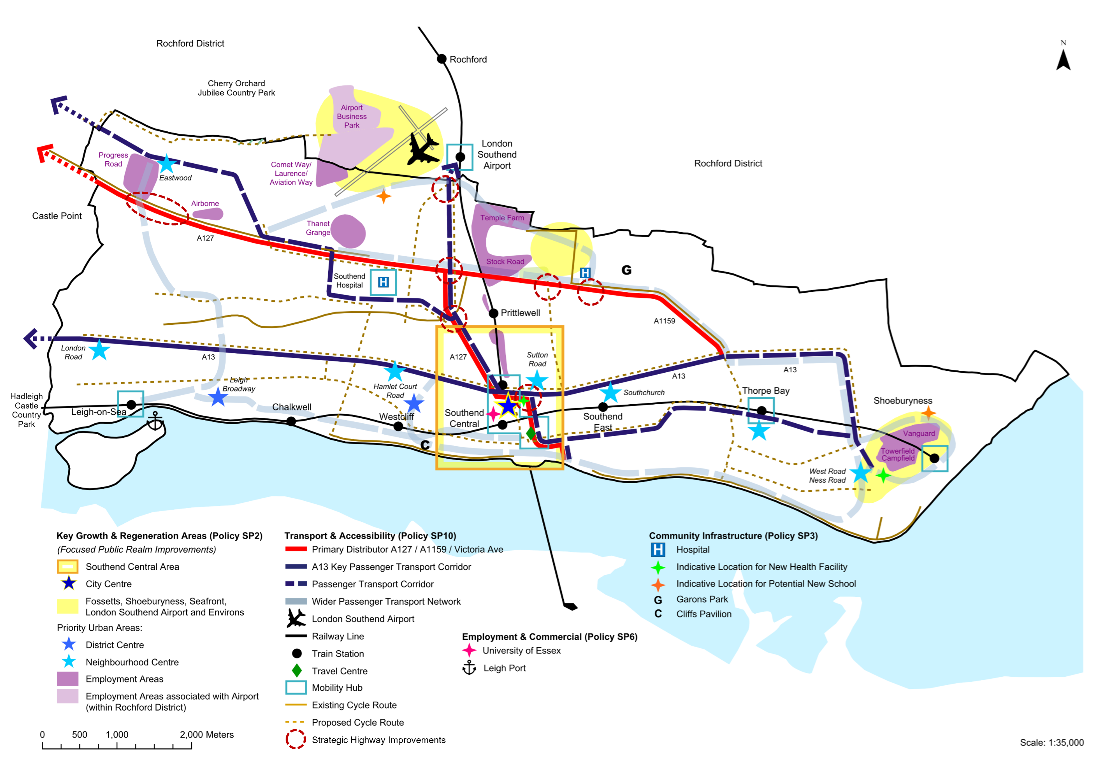
Why we have taken this approach
10.2 The physical location of the city and its geography present both challenges and opportunities. Opportunities to improve the strategic network linking the city to the rest of the country require that a strategic approach is taken with partners and operators. Working with bodies such as Transport East and the A127 Task Force will be essential to ensuring that enhancements to the network are pursued and new approaches are considered.
10.3 The densely developed nature of the city limits the amount of change that the existing road infrastructure can satisfactorily accommodate. Proposals such as grade separated junctions on the A127 would be prohibitively expensive and very difficult to deliver within an urban environment. Making the most effective use of existing infrastructure will therefore be essential. The use of electric and hydrogen fuelled vehicles will help to reduce vehicle emissions, and provision of re-fuelling infrastructure to enable this will be essential. Enhancing the level of bus provision and connectivity through improved transport hubs (and potentially through Park-and-Ride/Rail where feasible) would help to achieve changes in how people travel and provide sustainable solutions. They will however require a fresh look at how the existing infrastructure could accommodate such facilities through the Local Transport Plan (LTP) and relevant studies.
10.4 The Bus Service Improvement Plan 2024-2029 identifies Key Corridors for bus services and Mobility Hubs which will be linked together by frequent, high quality bus services, building upon the strengths of the commercial bus network, and providing links to local rail services, cycle parking and electric vehicle charging close to everyday shops and services. Mobility hubs will be prioritised at Leigh Station, City Centre (Southend Central and Southend Victoria Stations), Shoeburyness Station, Southend Hospital, Thorpe Bay Station, and London Southend Airport Station.
10.5 Co-ordinated provision of new and improved walking and cycling routes and facilities, especially to neighbourhood and local centres, will be essential if the ambition of connected neighbourhoods is to be achieved. It will be an important element in improving health and wellbeing and reducing emissions and highway congestion around the city. The emerging Southend-on-Sea Local Cycling and Walking Infrastructure Plan (LCWIP) sets out where improvements will be prioritised.
10.6 Significant technological innovation is expected to occur within the lifetime of the Local Plan. Digital technology, both in its own right but also as an enabler of new transport solutions. This covers everything from co-ordination of traffic signals to management of autonomous vehicles; the use of drones for cargo deliveries and "air taxis" for moving people in the future.
10.7 The Policy reflects the approach that developments which generate a significant amount of movement should be situated in sustainable locations. Sustainable locations are defined as sites which minimise the need to travel, such as the City Centre, and also takes advantage of the opportunities to utilise and enhance public transport and both the cycling and walking network. Consequently, it is considered appropriate that large retail, commercial, employment or leisure developments should be concentrated in locations where existing transport infrastructure can sustain such developments for the long-term, or where new developments can unlock opportunities to provide new services to both the new development and surrounding neighbourhood.
Have your say…
Please explain your answers
QSP10: Do you agree with draft Strategic Policy SP10: Transport and Connectivity? Please explain your answer.
Promoting Sustainable Transport & Reducing Congestion – development management policy
Reference to Strategic Objective and Strategic Policies
Strategic Objective 17
Strategic Objective 20
Strategic Objective 21
Strategic Objective 22
Strategic Policy SP10
Why we need this Policy
10.8 Sustainable Transport in Southend plays a key role in supporting economic growth, reducing carbon emissions, promoting equality of opportunity and improving the quality of life and health. Sustainable transport management will provide a number of benefits that contribute towards sustainable development such as:
- Reducing emissions and contribution to climate change;
- Improving health through better air quality and making walking and cycling an attractive alternative to the use of private motor vehicles;
- Helping equitable access to services for all, not putting those who cannot or do not own a car at a disadvantage; and
- Reducing congestion on the road network from car travel, which can have benefits for the economy.
10.9 New Development often generate additional traffic and can require new access requirements. The location of development and the intensity of the usage are the two crucial variables that will ultimately determine whether developments are sustainable in terms of the local or regional transport network. Therefore, developments, if positioned in sustainable locations, can provide tangible opportunities to improve the wider transport network. New Development should endeavour to minimise the need to travel and maximise the use of sustainable transport modes, especially given the compact nature of the city.
10.10 Improvements to active travel networks can contribute to improving the health of the population; enabling the creation of attractive complete neighbourhoods.
How the Policy Works
10.11 This policy will encourage modal shift, particularly to public transport, cycling and walking which will subsequently reduce greenhouse gas emissions and other pollutants and the use of private motor vehicles.
10.12 To promote sustainable development, the Policy further supports the national policy objectives of identifying and pursuing opportunities to promote walking, cycling and public transport use; providing for high-quality walking and cycling networks particularly with respect to 'complete neighbourhoods'; and ensuring that the design and access arrangements of new developments give priority first to pedestrian and cycling movements. The Council's Design SPD and national guidance, such as "Active Design" produced by Sport England, and Manual for Streets, should be followed.
10.13 The emerging LCWIP identifies Southend City Centre, Westcliff-on-Sea, Shoeburyness, Eastwood, Leigh (London Road), Leigh Broadway, Prittlewell Chase, Southchurch and Thorpe Bay as areas which contain a high density of trip attractors, providing opportunities for improving the pedestrian experience in terms of safety, attractiveness, comfort, directness and coherence. The highest potential areas for cycle growth in the city, based on existing cycle flow data and key points of interest such as town centres, hospitals and workplaces are Central Southend, Westcliff and Leigh, where short, medium and long-term route improvements can be focussed, providing safer and more attractive cycle routes, generally on quieter, more lightly trafficked roads.
10.14 Developments* should be supported by a Transport Statement or Transport Assessment. The current thresholds are set out in Council's Validation checklist. Comprehensive information should be provided to support submissions.
10.15 The Southend-on-Sea LTP seeks to tackle congestion by promoting active travel. It places greater emphasis on travel plans and by the incorporation of other sustainable travel modes to influence people's travel behaviour towards more sustainable alternatives. Applicants will need to agree appropriate sustainable travel measures with the Council prior to a planning application submission. A travel plan and arrangements for its monitoring will be required for any proposal where the Council considers it necessary, based on the potential individual or cumulative impact of the proposal on the area.
10.16 The overall aim is to limit the growth in traffic congestion as part of an overall package to make other more sustainable forms of transport more attractive. Developments should mitigate transport impacts according to the following hierarchy:
- reduce overall travel demand;
- minimise mode share by private car;
- seek to spread or time shift demand away from peak hours as well as considering off-peak effects;
- offset residual impact through highways improvements, which must be achieved with no adverse impact on highway safety or to users of sustainable modes.
10.17 Transport Assessment and Travel Plan thresholds are set out in the Local Validation checklist available on the Councils website.
Policy DM10.1: Promoting Sustainable Transport & Reducing Congestion
- Development should be located and designed so as to encourage walking and cycling and use of public transport routes, while reducing dependency on travel by private motor vehicle. This should include:
- designing developments to prioritise the needs of pedestrians, cyclists and users of public transport;
- phasing the development process so that walking and cycling infrastructure is in place and usable at the point of first occupation;
- ensuring that access to the development, and any traffic generated, does not cause undue harm to the local street scene, including the amenity of neighbouring properties and/ or public rights of way, and does not cause an unacceptable impact in terms of increased traffic congestion or highway safety;
- providing an appropriate amount and type of parking in accordance with Policy DM10.3;
- for development which generates a significant demand for travel and/ or is likely to have other transport implications: contributing to improved sustainable transport infrastructure off-site, including, where appropriate, bus priority measures and enhanced passenger information, and enhancements to the city's walking and cycling network.
- Development proposals should demonstrate that there is, or will be, physical and environmental capacity to accommodate the amount and type of traffic generated in a safe and sustainable manner, that the cumulative impact on the transport network can be satisfactorily mitigated, and other relevant local plan policies are satisfactorily addressed. In order to consider such impacts, developments* should be supported by a:
- Transport Statement, which assesses the impact of a development with relatively small transport implications, and a Travel Plan Statement**, which identifies how the development will maximise the usage of sustainable modes of transport; or
- Transport Assessment, which assesses the impact of a development when there would be significant impact on the transport network, infrastructure and services, and a full Travel Plan**, which will identify how the development will optimise the usage of sustainable modes, including necessary improvements and introduce new infrastructure as required to mitigate development impacts.
The applicant should view the Local List of Planning Validation Requirements (or any subsequent document) to ensure that they submit an appropriate Transport Statement or Transport Assessment with their planning application.
*Relevant thresholds for Transport Statement and Transport Assessment are set out within the Council's Local List of Validation Requirements.
** Travel Plans, and Travel Plan Statements, should seek to reduce dependency on motor vehicles by considering a range of measures, including car clubs, car sharing and pooling, real-time public transport information, marketing and communication materials and travel packs.
Have your say…
Please explain your answers
Q10.1: Do you agree with draft Development Management Policy DM10.1: Promoting Sustainable Transport and Reducing Congestion? Please explain your answer.
Ensuring that the highway network is safe and effective – development management policy
Reference to Strategic Objective and Strategic Policies
Strategic Objective 20
Strategic Policy SP10
Why we need this Policy
10.18 Southend has a strategic objective to improve accessibility, connectivity, sustainability, and ease of movement to, from and within the city. Strategic Policy SP10 sets out the framework for ensuring business as usual despite new development. This policy provides further requirements to ensure the continued safe and efficient movement of the network.
How the Policy Works
10.19 It is important for Southend to be able deliver new homes and jobs for its growing population, although this growth should not overly interfere with the day-to-day prosperity and function of the city's centres, employment areas and transport network. Deliveries during construction can contribute to congestion, as can servicing and deliveries when the building is operational. Innovative solutions such as the implementation of last mile deliveries by foot, cycle or zero emission vehicles will be supported.
10.20 While onsite, major development can require large amounts of deliveries and servicing, these activities require the use of heavy construction vehicles and often result in disruption on the network. Site phasing must be undertaken in order to reduce the impact of these activities on the network. Equally, the servicing of operational facilities, especially out of hours, requires careful consideration.
10.21 Development can mitigate disruption to existing residents and businesses by providing off street servicing space where practicable or implementing freight reduction measures can ensure that deliveries and servicing requirements do not have a negative impact on the road network. This is particularly important for high density residential or commercial developments in the Southend Central neighbourhood and City Centre, and on the strategic highway and bus routes within Southend.
Policy DM10.2: Ensuring the highway network is safe and effective
- To ensure the continued efficient movement of the highway and sustainable transport network while enabling growth, major development* must:
- consider the overall impact of the development on the surrounding area including impacts on traffic flows and congestion, provision for sustainable travel and environmental impacts such as noise and air quality;
- consider servicing and emergency vehicles requirements;
- utilise innovative solutions to ensure the lowest amount of disruption is made to the highway and sustainable transport networks during construction and operation.
- Development within Southend Central neighbourhood should be managed to minimise the impact of deliveries and freight traffic on the local highway and sustainable transport networks. In order to achieve this, major development proposals should:
- minimise the need for freight trips and seek to consolidate freight and servicing across the wider neighbourhood;
- adopt technologies/ practices to enable efficient servicing and deliveries to sites; and
- provide onsite servicing areas where practicable to allow all goods and refuse collection vehicles likely to service the development at the same time to be conveniently loaded and unloaded.
* Major development is defined as:
- The number of dwellings to be provided is 10 or more; or
- The development is to be carried out on a site having an area of 0.5 hectares or more and it is not known whether the development would constitute 10 dwellings or more
Have your say…
Please explain your answers
Q10.2: Do you agree with draft Development Management Policy DM10.2: Ensuring the highway network is safe and effective? Please explain your answer.
Parking Standards – development management policy
Reference to Strategic Objective and Strategic Policies
Strategic Objective 12, Strategic Objective 13
Strategic Objective 14, Strategic Objective 20
Strategic Objective 21, Strategic Objective 22
Strategic Policy SP10
Why we need this Policy
10.22 Southend is a densely populated city, and the demand for travel in Southend is expected to increase as the city realises its regeneration and growth ambitions, and as a result of changing lifestyle choices. The Southend Local Transport Plan (LTP) seeks to tackle congestion by placing greater emphasis on travel plans and by the incorporation of other smarter choice measures Managing car parking space provision can actively encourage more sustainable choices to be made in respect to the need to travel and the choice of mode.
10.23 Given the interrelationship between Southend and neighbouring districts both in terms of travel to work patterns and shopping and leisure trips, Southend's parking standards have been developed to take account of parking standards developed at County levelEssex Planning Officers Association (EPOA) Parking Standards, as well as local factors. This includes consideration of accessibility in setting standards, the importance of electric charging facilities, integrating parking as part of the wider design process and changes in the size and type of vehicles. Applying parking standards, where appropriate, will enable the Council to provide clarity and certainty for developers and residents. This is supplemented by Policy DM7.1: Design Quality and Public Realm and the Design and Townscape Guidance SPD, and any other subsequent design code/ guidance, in respect to the design and layout of parking areas and cycle parking facilities, and consideration of context.
10.24 The Southend LTP seeks to promote sustainable travel options, focussing initially on journeys to the City Centre, and linking reductions in on-street parking provision to the promotion of public transport, walking and cycling. Parking standards set a requirement for the City CentreWithin Southend Central neighbourhood, analysis of 2021 census data highlights that car ownership is significantly lower for residents living in and around the City Centre than in other areas of the city. Overall car ownership in 2021 was 1.16 per household (1.4 per house; 0.8 per flat) across the city but varied between neighbourhoods with Southend Central 0.8 cars per household (1.1 per house; 0.6 per flat). The development of the Parking Standards therefore reflects this., continuing the approach set out in the Council's Development Management Document. This recognises that the City Centre has good public transport options and have services and facilities within walking distance making sustainable travel a realistic alternative for many people without compromising viability.
How the Policy Works
10.25 See Appendix 10 for full list of parking standards. The parking standards as set out in Appendix 10 apply minimum standards to residential ('trip-origin') development as well as other land uses to ensure that a sufficient level of parking is provided within new development. However, these standards may be applied flexibly where it can be demonstrated that residential development is proposed in a sustainable location with frequent and extensive links to public transport (such locations have easy access to education, healthcare, food shopping, and employment opportunities, and have direct and easy pedestrian access to more than one means of public transport which offers frequent services, such as train stations and bus stops), particularly within the most sustainable areas of Southend Central neighbourhood, and where the rigid application of these standards would have a detrimental impact on local character and context. In addition, reliance upon on-street parking will only be considered appropriate where it can be demonstrated by the applicant that there is on-street parking capacity.
10.26 Garages are often an important feature of a residential development and are multifunctional in that they are used for both car parking and general storage. Garages need to be large enough to accommodate a modern, family sized car, cycles and some storage and therefore internal dimension below 7.0m x 3.0m will therefore not be considered or counted as a parking space.
10.27 Parking standards should not be considered in isolation but as an important component of high-quality design. It is essential that parking is considered at the earliest stages of design so that cars doesn't visually dominate the development and issues such as sustainable drainage and landscaping (as appropriate) are satisfactorily incorporated in the design. This will require that a number of different approaches to how parking is provided depending on the location and scale of development.
10.28 There is significant potential to increase the level of cycling in Southend. This will help reduce congestion, contribute to zero carbon ambitions and improve the health of users. Provision of safe, good quality and secure cycle parking both at origin and destination will be an important element of achieving this.
10.29 Provision should be made for the parking needs of the whole range of highway users, including those with mobility difficulties. This includes blue badge holders and those with mobility scooters. A move towards low emission transport will require good quality recharging facilities for electric vehicles where regard should be had to Policy DM9.2 Energy.
10.30 A "Park and Ride/Rail" site and a location to transfer goods to enable low emission "last mile delivery" may come forward within the plan period. This will be considered within the LTP. Key criteria for their consideration are set out in the policy.
10.31 A parking strategy should be produced by developers as part of the wider transport assessment for larger developments. These would form an important context for consideration of individual applications.
10.32 New vehicle crossovers help create new off-street parking for individual properties. They do however impact on-street parking and affect highway safety and sustainable transport networks. Consideration of these effects, plus cumulative impacts when considered with existing crossovers will form a central element of the consideration of such applications.
Policy DM10.3: Parking Standards
- All development should meet the parking standards (including cycle parking) set out in Appendix 10. Residential vehicle parking standards may be applied flexibly where it can be demonstrated that the development is proposed in a sustainable location with frequent and extensive links to public transport and/ or where the rigid application of these standards would have a clear detrimental impact on local character and context. Reliance upon on-street parking will only be considered appropriate where it can be demonstrated by the applicant that there is on-street parking capacity. All parking provision should contribute to high quality design (see Policy DM7.1 Design Quality and Public Realm). The parking standards in Appendix 10 will be kept under review.
- To prioritise and promote alternatives to private vehicle use, development proposals must prioritise the needs of pedestrians, including disabled persons and those with impaired mobility, and cyclists, including safe, secure and covered on-site cycle parking and, where appropriate, changing facilities, creating safe and secure layouts that minimise conflicts with traffic and avoid street clutter and barriers to movement.
- All major development proposals must incorporate and include provision for:
- safe, convenient and legible access to public transport for pedestrians and cyclists, and sustainable alternatives to reduce dependency on vehicles. All other development should seek to include such measures where site specific circumstances allows; and
- servicing and emergency vehicles.
- Provision of parking for Car Clubs will be supported with provision to be agreed to the satisfaction of the Local Planning Authority, particularly in car free/ car lite developments with lower car parking provision.
- Provision of vehicle crossovers for new or existing developments should not have any detrimental impact on highway safety and the effective functioning of bus and cycle routes and not adversely impact overall on-street parking levels.
- Electric vehicle charging points and infrastructure should be provided in line with the standards in Policy DM9.2: Energy. Infrastructure for public electric vehicle charging points should be focussed within neighbourhood and local centres and public car parks. On-street residential charging points should be located where they would not inhibit access for pedestrians and other road users.
- Provision of a "Park and Ride/Rail" will be supported subject to meeting the following requirements:
- be close to and have good access to the strategic road network;
- incorporate a high-quality passenger waiting area with facilities and VMS signage;
- be linked to bus priority measures on the network;
- incorporate electric charging points;
- incorporate Low-Impact Lighting and CCTV security;
- be supported by a full Transport Assessment.
- Provision of Transhipment parking for transfer of goods from HGV's and for onward delivery, especially by low carbon alternatives within the urban area will be supported. Such locations should have:
- good access to the strategic road network;
- electric vehicle recharging facilities;
- welfare facilities for drivers;
- storage facilities for goods as appropriate;
- consider noise mitigation measures as appropriate;
- be supported by a full Transport Assessment.
Have your say…
Please explain your answers
Q10.3: Do you agree with draft Development Management Policy DM10.3: Parking Standards? Please explain your answer.
Improving Railway Stations – development management policy
Reference to Strategic Objective and Strategic Policies
Strategic Objective 1
Strategic Objective 20
Strategic Objective 22
Strategic Policy SP10
Why we need this Policy
10.33 Southend benefits from a "metro quality" of service on its rail corridors. The C2C line provides around four trains per hour east-west to seven stations across the south of the city and onward to Basildon and London Fenchurch Street. The Greater Anglia line from Southend Victoria to London Liverpool Street provides access from Southend through to London Southend Airport and onto Stratford and London Liverpool Street. The city's railway stations perform an important role in supporting complete and accessible neighbourhoods.
10.34 The two railway lines operate in isolation to each other with a half mile gap between Southend Central and Victoria stations along the High Street in the City Centre. While all the stations operate effectively there are opportunities for improvements, especially to the two central stations. Southend Central station in particular is somewhat hidden from the High Street and has a poor external environment, particularly to its forecourt fronting Clifftown Road. While there is some level of bus interchange at most stations it is only at Southend Victoria that this is particularly effective.
How the Policy Works
10.35 Southend Central and Southend Victoria railway stations are key gateways to the city and are integral to the sustainable development of Southend Central neighbourhood, including the City Centre. The rail stations of Leigh, Thorpe Bay, Shoeburyness and at London Southend Airport have also been identified as mobility hubs, which are places in a community that can maximise shared transport and interchange with public transport and active travel in spaces designed to improve the public realm for all.
10.36 How this will be developed for specific stations would require development of site-specific considerations. Opportunities to improve the accessibility, environment and interchange at stations will be given positive consideration, especially where they facilitate more effective integration with other sustainable modes.
10.37 The Elizabeth Line recently opened, providing connections from Shenfield through central London to the west of England, and providing connections for travel to Kent. There is potential for the line to be extended to Southend Victoria during or beyond the plan period.
Policy DM10.4: Improving Railway Stations
- Proposals to enhance the role of railway stations, access to them, and the quality of surrounding public realm and station forecourts will be supported where these meet other relevant Local Plan policies. In particular Leigh-on-Sea, Southend Central, Southend Victoria, Thorpe Bay, Shoeburyness and Southend Airport rail stations will be prioritised for enhanced public realm and improved multi-modal connections.
- Development will be supported where it would contribute to the implementation of enhanced rail infrastructure, capacity, improved timetabling or operational improvements.
Have your say…
Please explain your answers
Q10.4: Do you agree with draft Development Management Policy DM10.4: Improving Railway Stations? Please explain your answer.
Telecommunications – development management policy
Reference to Strategic Objective and Strategic Policies
Strategic Objective 1, Strategic Objective 3
Strategic Objective 20, Strategic Policy SP10
Why we need this Policy
10.38 Telecommunications, whether by full fibre to properties or by cellular data (such as 5G) are essential to the economy and transport systems. However, the networks do have locational needs and physical impacts that need to be addressed through the planning system.
How the Policy Works
10.39 Digital infrastructure is a constantly evolving technology. This policy seeks to provide for the two main forms of digital communication: cellular communications that require equipment be placed on buildings and masts to relay signals, and 5G (and in future, 6G) that requires a denser network of cells to function, thus a need for more equipment, often at greater height.
10.40 Telecommunications also have a role in providing real time transport information. Bus stops and shelters provide real time service update, and signage also indicates public parking capacity within the City Centre.
10.41 Not all telecommunications development requires planning permission as set out by the relevant legislation, but where planning permission or prior approval is required, the provision of Policy DM10.5 apply.
10.42 Full fibre relies on underground networks. City Fibre have already installed a new network throughout Southend. To maximise the benefits of this it is essential that any new premises are constructed in such a manner that enables easy access to the network, thus avoiding additional costs at a later stage for retrofitting. Permitted development rights have been altered nationally to facilitate this for residential uses, but the same principle of easy access should apply to all uses.
10.43 The Council will consider a range of impacts in determining applications, including cumulative impacts. Visual impacts are likely to be most common. Because of the potential site-specific impacts in a very densely populated urban area, the Council encourages the use of designs tailored to the locality rather than the use of standard models, and pre-application discussions are encouraged in order to resolve any issues.
Policy DM10.5: Telecommunications
- Where planning permission, including prior approval, is required, proposals will be supported where:
- if a new mast is proposed there are no suitable existing masts, buildings or other structures, including those used by other operators, where the proposed apparatus could be operated;
- the design and siting of any new or extended infrastructure, including on street cabinets, seeks to minimise and mitigate visual impact and respects the character of the building or area in which it is located;
- the siting of the proposed apparatus and associated structures minimises impacts on the operation of other electronic devices within the surrounding area;
- any other impacts, including noise and impact on airspace for drones and other forms of aircraft, are addressed;
- supporting documentation is proportionate but related to the location.
- Fibre to the Premise (FTTP) provision will be expected for all new premises (residential and non-residential) unless this is already covered by Building Regulations. Exceptions to this policy on the basis of viability or feasibility of making such provision should be supported by evidence to the satisfaction of the Council.
Have your say…
Please explain your answers
Q10.5: Do you agree with draft Development Management Policy DM10.5: Telecommunications? Please explain your answer.
11. London Southend Airport
Strategic Policy
Where we are now
- There has been an airfield on the current site for over 100 years and during the 1960's Southend airport was the 3rd busiest in the UK
- The airport straddles the administrative boundaries of Rochford District Council and Southend City Council
- London Southend Airport is a key economic asset and local employer with 87% of employees living in the SS postcode area (covering Southend, Rochford, Castle Point and Basildon).
- A Joint Area Action Plan (JAAP), prepared with Rochford District Council, sets out the current planning framework to 2031 for London Southend Airport and its environs.
- In 2019 the Airport attracted over 2.1 million passengers as well as freight and General Aviation users. Covid had a significant impact with passenger numbers dropping by over 90%, but these are predicted to recover and exceed pre-covid levels by 2026-27.
- The Vulcan Aircraft XL426 is preserved at the Airport.
- A Section 106 legal agreement and associated documents control impacts of the airport, including total air traffic movements and noise flight preferential routes. A summary can be found here – London Southend Airport Operational Controls Summary Table
Where we want to be
Strategic Objective 5
Strategic Objective 15
Strategic Objective 20
Strategic Objective 22
Strategic Objective 23
Supporting Documents
Key supporting documents that underpin the policies are available on the Council's Evidence Documents | Southend Local Plan
How we are going to get there
Strategic Policy 11. London Southend Airport
- The Council will continue to work with Rochford District Council to deliver the existing Joint Area Action Plan (JAAP) for the Airport and environs, along with any future review or preparation of a joint masterplan as required. This includes policies governing the development and monitoring of airport operations; development of employment sites surrounding the airport within the JAAP boundaries; and promotion and monitoring of sustainable travel opportunities for both staff and visitors.
- Opportunities to enhance the airport and associated train station as a sustainable transport hub and to improve surface access, minimise congestion and environmental impacts will be supported.
- The development of skills training and work placement initiatives between the airport, on-site and neighbouring employers, local educational institutions and local communities, will be supported. This will help increase both the aviation and non-aviation-related skills base in the local area and meet local employment needs.
Airport Safeguarding
- Development that would adversely affect the operational integrity or safety of London Southend Airport will be assessed to ensure as far as practicable, that the airport and its surrounding airspace is not adversely impacted by the proposal. With respect to operational considerations, this includes (but is not limited to) concerns over height of buildings associated cranes, telecommunications apparatus, lighting, glare, significant bird activity, and proximity to Public Safety Zones.
Airport Expansion
- Proposals for expansion of the airport and its operation, together with any associated surface access improvements, will be assessed against the Local Plan and JAAP policies taking account of the wider sub-regional impact of the airport. Proposals for development will only be supported where all of the following criteria are met, having regard to the nature and scale of such proposals as appropriate:
- they are Airport related;
- they are in accordance with the adopted JAAP or an up-to-date joint Airport master plan published by the operators of London Southend Airport and adopted by Rochford District Council and Southend City Council;
- they fully assess the impacts of any increase in Air Transport Movements on surrounding occupiers and/or the local environment (in terms of noise, disturbance, air quality flooding, waste management, water management, ecological and climate change impacts);
- achieve noise reduction or no material increase in day or night time noise in accordance with the airport's most recent Airport Noise Action Plan;
- include proposals that will, over time, result in a significant diminution and betterment of the effects of aircraft operations on the amenity of local residents in the area, through measures to be taken to secure fleet modernisation or otherwise;
- incorporate sustainable transportation and surface access measures that, in particular, minimise use of the private car, maximise the use of sustainable and inclusive transport modes and facilitate modal shift, in accordance with the London Southend Airport Surface Access Strategy;
- include a clear and measurable plan for achieving zero-carbon operation of the Airport terminal and facilities and working with aircraft operators to reduce their carbon footprint, including through the introduction of the latest most efficient aviation industry recognised aircraft;
- consider and appropriately address the impact on heritage assets including below ground archaeology;
- include robust monitoring mechanisms that ensures the current and future operations at the airport are fully in accordance with the policies of this plan and any future planning permission/s which is/are granted.
Why we have taken this approach
Background
11.1 London Southend Airport is a key regional transport hub providing a gateway to Europe and helping to generate important economic investment and jobs in Southend and south Essex. The airport lies partly in Southend-on-Sea and partly in the District of Rochford and both Southend and Rochford Councils are relevant planning authorities.
11.2 As part of the Airport's expansion and development plans in 2010, Southend Council considered very carefully how best to achieve an appropriate balance between encouraging airport development and economic growth; while adopting tough measures to protect residents as much as possible from the environmental impact of aircraft movements, particularly at night.
11.3 Regular passenger flights to European destinations commenced from the airport in April 2012, after planning permission for the runway extension was granted in April 2010. At that point new controlsThe controls are set out in two planning agreements (s.106 agreements) which can be accessed on the Public Access pages of this website under application reference 09/01960/FULM. The controls are replicated in leases which can be obtained from the Land Registry. came into effect, these impose much more stringent controls on flights, and especially night time movements. Compliance is monitored by the Airport Consultative CommitteeThe Airport Consultative Committee (ACC) meets each quarter and is comprised of representatives from local authorities, community groups and airport users under the provisions of the Civil Aviation Act 1982 (Section 35) and has no executive powers.. The new controls included the following important restrictions:
- the number of possible night flights per month has been reduced from more than 900 to 120;
- the night period has been increased from 6 hours to 7.5 hours;
- strict noise controls have been introduced on aircraft operating from the airport;
- night time passenger flights are generally restricted; and
- there is now a runway preference scheme to restrict the number of take offs and landings over the south west, Leigh-on-Sea area.
11.4 In addition, a Frequently Asked Questions document has been prepared, together with a clear summary of the new controls Operational Controls Summary Table.
Adopted Joint Area Action Plan (JAAP) for the Airport and environs
11.5 Southend-on-Sea City Council, together with Rochford District Council, jointly prepared and adopted the Southend Airport and Environs Joint Area Action Plan (JAAP) in 2014. This followed permission for the extension of the airport's runway, seeking to maximise local economic benefits of the growth through the vision of an area that realises its potential as a driver for the sub-regional economy, providing significant employment opportunities and ensuring a good quality of life for its residents and workers. The JAAP established the following objectives to achieve this:
- maximising the economic benefits of a thriving airport and related activity;
- ensuring good connectivity to the development area by all modes of transport, with appropriate improvements to sustainable transport and the highway network;
- ensuring a high-quality public realm and environment for residents and workers;
- seeking maximum return on public investment through attracting inward investment; and
- developing efficient use and upgrading of existing employment land resources.
11.6 The JAAP sets out how the airport is expected to grow in a sustainable manner up to 2031 and includes policies covering both development within the curtilage of the airport itself, and that of designated employment sites within the surrounding designated area, which were to deliver over 100,000 m2 of employment floorspace and 5,000 additional jobs. These jobs contribute to the delivery of the jobs totals for Rochford District Council and Southend-on-Sea City Council – the apportionment to each district is based on a 50-50 split of the overall jobs total to be provided within the JAAP areaJAAP 2014 Policy E1 – General Development Considerations.
11.7 Whilst the intervening years since the JAAP's adoption have seen the emergence of a range of unforeseen impacts on the airport (e.g. COVID-19 pandemic and more recent socio-economic impacts), over time the airport and adjacent employment sites have experienced substantial growth and development, guided by the JAAP policies.
11.8 The JAAP continues to provide a relevant long-term vision for the Airport and its environs. The Airport's growth to date has helped to deliver additional jobs alongside substantial new infrastructure. This has included a new business park, state of the art air traffic control tower, runway extension, railway station, passenger terminal and associated on-site hotel facilities. It has also witnessed new and improved bus routes and supported successful funding bids for capacity improvements to the local road network.
11.9 In 2019/20, the Airport served approximately 2.1 million passengers which was an increase of around 43% from the previous year, and a doubling of 2017 numbers. Whilst the Airport has been deeply affected by economic circumstances during and following the pandemic it remains well-placed to grow in the future and is predicted to recover and exceed pre-covid levels by 2026-27.
National Aviation Policy and Guidance
11.10 Planning permission for the Airport limits the number of air traffic movements to 53,300 per year with around 37,000 movements taking place in the 2019-20 financial year. Whilst the use of larger aircraft could allow passenger movements to increase, any longer-term growth aspirations beyond 53,300 movements a year would require a new planning framework and agreement. This framework would need to weigh up the various benefits and challenges presented by the Airport's growth, including the strong economic benefits alongside air quality, traffic, climate change and noise considerations. It should also consider recent Government aviation policy and related guidanceAviation policy framework - GOV.UK (www.gov.uk) (2013); Beyond the horizon the future of UK aviation (publishing.service.gov.uk) (2018); Overarching aviation noise policy - GOV.UK (www.gov.uk) (2023); Flightpath to the future: a strategic framework for the aviation sector - GOV.UK (www.gov.uk) (2022), including:
- to make the best use of existing runway capacityBeyond the horizon the future of UK aviation (publishing.service.gov.uk);
- to ensure the aviation sector makes a significant contribution towards reducing global emissions and achieving Net Zero;
- to ensure communities surrounding airports share in the economic benefits and adverse impacts such as noise are mitigated wherever possible;
- to limit and where possible reduce the number of people significantly affected by noise;
- that Government, local authorities and airports should work together to improve air quality.
11.11 The Government is clear that the local planning application process is equipped to deal with applications for airports to increase passenger caps by fewer than 10 million passengers per annumBeyond the horizon the future of UK aviation (publishing.service.gov.uk) (2018), and is supportive of airports seeking to expand. Local authorities must consult fully and judge such proposals on their individual merits, taking careful account of all relevant considerations, particularly economic and environmental impacts, along with proposed mitigation.
11.12 The Airports National Policy Statement (2018), although focused on building strategic aviation hub capacity at London Heathrow, contains a useful set of assessment principles and impacts in Chapters 4 and 5, many of which are generic and apply to all airport expansion proposals. These include:
- climate change adaptation and carbon emissions;
- pollution control and environmental protection (including air/water quality);
- noise;
- health;
- accessibility;
- surface access;
- resources and waste management;
- landscape and visual impact;
- community engagement;
- skills; and
- flood risk
11.13 Any future proposals to extend or adapt Southend Airport in respect of its aviation and ancillary activities should have regard to these principles.
London Southend Airport Recovery
11.14 Since the devastating impact of the Covid pandemic on its operation and use, the Airport now has long-term plans to increase passenger numbers beyond pre-pandemic levels. The gradual return of flights and passenger numbers indicates a recovery is underway as witnessed by the significant increase in destinations from three to fifteen, a return to year-round flying, a successful transition of ownership and the return of airline partner easyJet as part of a multi-year deal which will see three based aircraft on-site from the summer of 2025.
11.15 A return to growth is likely to have a range of both positive and negative impacts on the local area and any growth beyond the current agreed operating limits will need careful management through the planning system. Expansion on the site brings opportunities for direct and indirect local employment (including enhancing skills and training), for increased infrastructure investment, and in improving local sustainable transport connectivity, using the Airport site as a 'hub' for different modes of transport. However, it also brings a risk of issues such as air and noise pollution, traffic congestion and increased carbon emissions.
11.16 The Council will continue to work with partners to realise the airport's economic potential as the aviation industry recovers, whilst having regard to local amenity and environmental issues. The JAAP, along with the established forums for dialogue between the airport and relevant partners and stakeholders (i.e., the Airport Consultative Committee, Airport Transport Forum, Community Noise Forum, Airport Liaison Group and Transport Liaison Group), will enable the Council to regulate the operation of the airport through balancing noise and environmental issues with residential amenity.
11.17 In the longer term, the Council will work with the Airport, Rochford District Council, Essex County Council and other partners to develop an appropriate planning framework to replace the JAAP, should this be deemed necessary. It will also work constructively with partners to ensure a robust and up-to-date suite of monitoring documents is in place to manage Airport operations, including any changes to the existing Section 106 agreement.
11.18 In accordance with the existing Section 106 agreement, the Council will continue to work with the airport and other local authority partners to improve and promote sustainable travel opportunities for both staff and visitors at the airport. Opportunities to further enhance the airport's role as a sustainable, multi-modal transport hub, acting as an interchange of bus, rail and active travel routes for the wider area and to improve surface access to the Airport, will also be explored.
11.19 In the event that planning permission was sought to grow the airport prior to a review of the JAAP, the Council would expect this to have regard to Policy SP11 and be in conformity with an up-to-date joint Airport MasterplanAviation Policy Framework (publishing.service.gov.uk) (2013). Annex B contains guidance on the content of master plans, airport transport forums and airport surface access strategies. published by the operators of London Southend Airport and adopted by Rochford District Council and Southend City Council.
Airport Safeguarding
11.20 There are two elements to safeguarding at London Southend Airport.
- Public Safety Zones (PSZ's) are triangular areas located at the end of runways as defined in the DfT Policy Paper "Control of development in airport public safety zones" (updated October 2021). PSZ's restrict new development such as housing and employment within the designated area.
- Airport Safeguarding Zones are intended to make sure that there isn't a conflict between new development above a certain height and the safe operation of aircraft, including any impacts on radar, instrument landing systems and air traffic control equipment. As Local Planning Authority the City Council consults the Airport on applications that meet the defined locational and elevational criteria and are set out in Safeguarding maps.
Have your say…
Please explain your answers
QSP11: Do you agree with draft Strategic Policy SP11: London Southend Airport? Please explain your answer.
12. Place Specific Neighbourhood Policies
THE NEIGHBOURHOODS OF SOUTHEND
PLACE SPECIFIC POLICIES
12a. This chapter looks at Southend's neighbourhoods, setting out the context for each and any key issues, providing a vision and policy approach.
Figure 12.1: Southend's Neighbourhoods
12.1 As with any city, Southend is not a single homogenous place. Rather, it is a collection of separate and distinct places or neighbourhoods which have grown together over time to create a substantial conurbation. The Local Plan has sought to consider the issues facing the different neighbourhoods of Southend. Profiles for each of the neighbourhoods are available here: https://localplan.southend.gov.uk/evidence-documents
12.2 Within the following chapter of the Local Plan, each of the nine neighbourhoods is presented, setting out their context and key issues, key facts, a vision for the neighbourhood, map and neighbourhood policy, together with a table of potential site proposals, as applicable.
12.3 The neighbourhood policies are set out in the following sections:
- Eastwood (Policy N1) (Site Proposals Policy N1i)
- Leigh (Policy N2) (Site Proposals Policy N2i)
- Prittlewell (Policy N3) (Site Proposals Policy N3i)
- Westcliff (Policy N4) (Site Proposals Policy N4i)
- Southend Central
- City Centre (Policy N5a) (Site Proposals Policy N5ai)
- Central Seafront area (Policy N5b) (Site Proposals Policy N5bi)
- Central Area surrounding residential areas (Policy N5c) (Site Proposals Policy N5ci)
- Central Area Car Parking (Policy N5d)
- Southchurch (Policy N6) (Site Proposals Policy N6i)
- Fossetts (Policy N7) (Site Proposals Policy N7i)
- Thorpe Bay (Policy N8)
- Shoeburyness (Policy N9) (Site Proposals Policy N9i)
12.1 Eastwood
Context and Key Issues
Eastwood Area Profile
- Eastwood is suburban in character on the north-west fringes of the city. It is a relatively modern part of Southend, principally featuring post-war buildings. A substantial part of Eastwood is laid out to cul-de-sac style residential development, in contrast to the classic grid structure that defines large parts of the city.
- The style and format of buildings varies significantly but includes chalet style houses and more substantial properties in the 'Nobles Green' area. Eastwood is a relatively low-density part of Southend and is well served by public open space, including at Eastwood Park, and nearby within Rochford District Council, Cherry Orchard Way Country Park and Edwards Hall Park. There are opportunities to enhance active travel, promoting access through the neighbourhood, including to open and green spaces.
- The neighbourhood is bounded to the south by the A127 and to the north by open countryside, designated as forming part of the Metropolitan Green Belt within Rochford District.
- Rayleigh Road is home to a number of retail/ commercial centres, providing a range of local shops and services. It also provides a main transport corridor and bus route linking Eastwood with the City Centre and Rayleigh to the west. The retail/ commercial centres at Rayleigh Road may offer potential opportunities for residential intensification, with flats above shops, and would benefit from public realm enhancements and urban greening. In addition to these centres, there are larger format supermarkets at the junction with Progress Road and at Western Approaches retail park.
- There are frequent east-west bus routes focussed along Rayleigh Road, however the nearest stations at Leigh and Rayleigh (in neighbouring Rochford district) are some distance away, compounded by a lack of public transport connections, running north/ south – there is opportunity to enhance north/ south public transport connections, improving connectivity with Leigh-on-Sea railway station, connections to the City Centre and to the Airport.
- Eastwood is home to two employment growth areas at Progress Road and Comet Way, which offer potential for intensification and regeneration for employment uses, and several industrial/ business estates at Airborne Close, Airborne Industrial Estate, Aviation Way, and Laurence Industrial Estate, that provide local job opportunities.
Vision
12.4 Eastwood will be a sustainable suburban area interspersed with mature parkland connected by enhanced cycle and pedestrian links, and a quality public realm, which will improve connections within the existing urban area and to the surrounding countryside. The vibrant retail/ commercial centres on Rayleigh Road will continue to serve the local community, well served by buses, connecting the neighbourhood with Southend City Centre and Rayleigh, and providing opportunity for new homes and commercial enterprise, including living above shops.
12.5 Residents will benefit from good access to shops, services, local jobs, and public transport. The neighbourhood will benefit from improvements to existing local play areas, providing opportunities for play and recreation for children and young people. The employment areas aligning the A127 will offer local job opportunities, focussed at: Progress Road, Comet Way, Airborne Close, Airborne Industrial Park, Aviation Way, and Laurence Industrial Estate. These areas will benefit from enhanced access.
Have your say…
Please explain yours answers
QN1a: Do you agree with the Vision for Eastwood? Please explain your answer.
Figure N1: Eastwood Neighbourhood
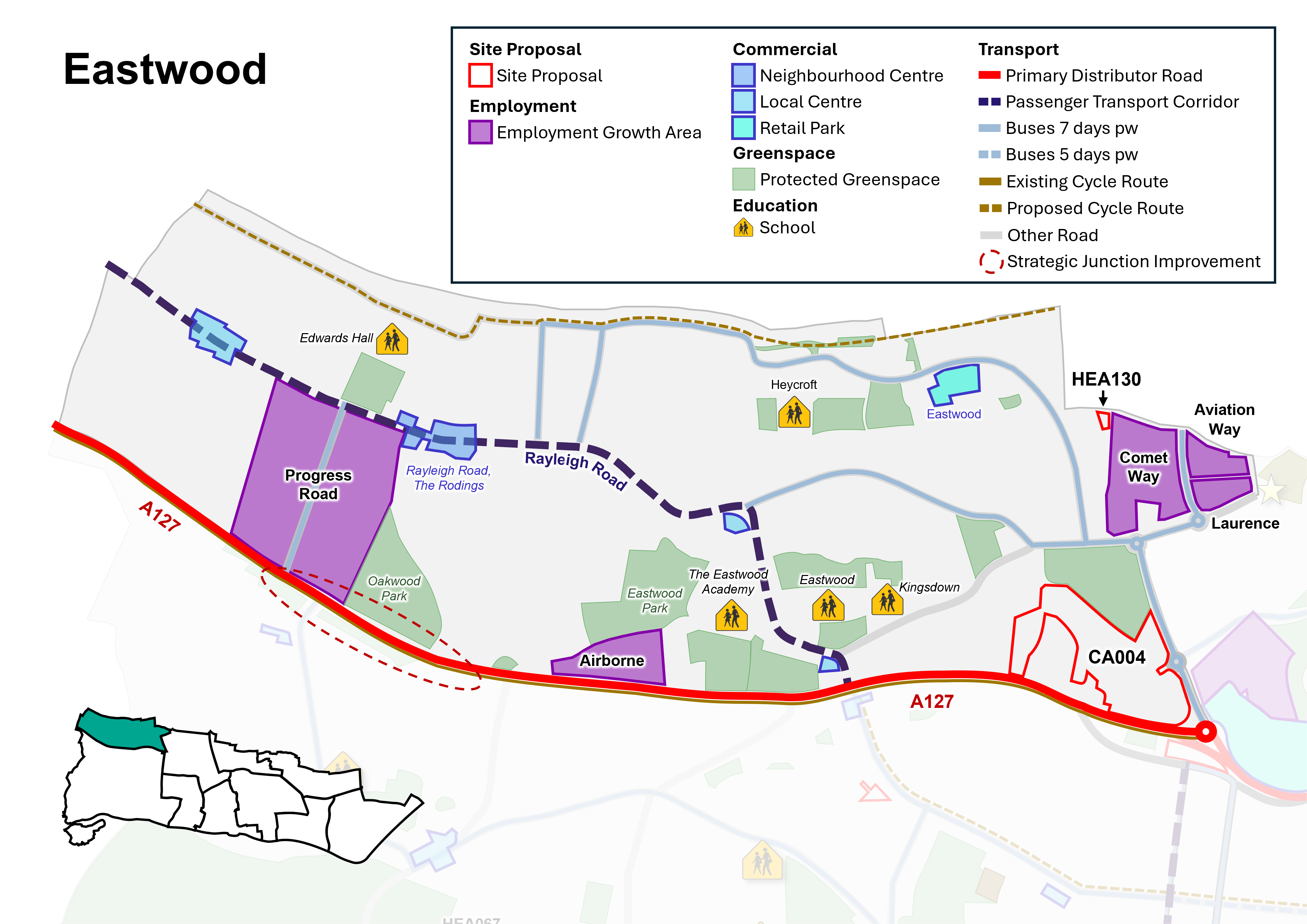
Neighbourhood Policy N1: Eastwood
All development should be in accordance with the Development Plan for the city. Specific requirements for Eastwood are:
Health and well-being
- New development must contribute to healthy lifestyles and address health and wellbeing having regard to Policy SP4.
- New development must be aligned with the provision of necessary infrastructure (including social infrastructure such as health and education) and not place a damaging burden on existing provision (Policy SP3). The Council will seek to protect and manage community facilities and sport and recreation facilities in line with Policies DM4.1 and DM4.2.
Homes
- Seek to safeguard existing dwellings, including family housing, and provide for new homes in line with Policy SP5, DM5.2, DM5.3 and DM5.4 and as per relevant sites identified for residential development in Policy N1i (Policy Table N1i).
- Positively consider windfall development particularly where they are of good quality design and optimise the use of land within the Neighbourhood Centre and Passenger Transport Corridor.
Economy and Tourism
- Seek to manage employment land and promote economic growth in line with Policy SP6 and DM6.1.
- Protect and promote the provision of additional employment floorspace within identified employment areas in line with Policy DM6.3, including within the employment growth areas of Progress Road and Comet Way and the industrial/ business estates at Airborne Close, Airborne Industrial Park, Aviation Way and Laurence Industrial Estate.
- Manage and support the provision of Class E retail and commercial uses accordance with the retail hierarchy within identified Neighbourhood and Local Centres and improve accessibility in line with Policy DM6.4.
Urban Design, Character and Heritage
- The Council will support good quality design that contributes positivity to the creation of successful places and optimises the use of land having regard to local character and context in line with Policy SP7 and DM7.1.
- Support public realm improvements and urban greening focused to the Neighbourhood and Local Centres, and Retail Parks.
Natural Environment and Climate Change
- Protect and enhance the green and blue Infrastructure network, including protected green space and parks, in line with Policy SP8 and DM8.2.
- Establish an effective green grid, including green corridors, and new and improved public green space, particularly the neighbourhood parks of Oakwood and Eastwood.
- Promote enhancements to existing play space facilities and new facilities within the neighbourhood to improve quality and access.
- Manage and promote tree planting within the neighbourhood and as part of new development, as set out in Policy DM8.6.
- Development should seek to avoid the risk of flooding, unless otherwise allocated for development, and incorporate sustainable urban drainage systems (SuDS) (Policy DM9.4).
Transport and connectivity
- Widen travel choice, particularly by walking and cycling, rail, bus (including the enhancement of existing routes and new routes as part of the wider passenger transport network, and demand-responsive transport), car share/ clubs, and taxi in line with Policy SP10.3.
- Promote improvements to the passenger transport corridor along Rayleigh Road, and wider passenger transport network, including enhanced connections to Leigh Railway Station, London Southend Airport and Airport Business Park, and via Progress Road.
- Promote opportunities for improvements to the walking and cycling network, particularly along Rayleigh Road and to the northern edge of the neighbourhood (Figure N1).
- Infrastructure for public electric vehicle charging points should be focussed within neighbourhood and local centres and public car parks. On-street residential charging points should be located where they would not inhibit access for pedestrians and other road users.
Have your say…
Please explain your answer
QN1b: Do you agree with Neighbourhood Policy N1: Eastwood? Please explain your answer.
12.6 The local plan designates land for particular purposes, such as to protect valuable green space and key employment areas. The plan also includes site proposals that identify specific sites for particular uses. This process ensures that land is utilised effectively and strategically and will guide development decisions on future planning applications across the city. See Appendix 2 and accompanying Policies Map for more information.
Policy N1i: Eastwood Site Proposals
- Within Eastwood, allocate sites, as defined on the Policies Map, for development as set out in Policy Table N1i (see also Figure N1):
Policy Table N1i: Sites in Eastwood
|
Ref No |
Site Name |
Proposed Use |
Approx. Homes |
|
Allocation |
|||
|
CA004 |
Nestuda Way |
Mixed-use commercial development opportunity with potential for improved access, burial ground, energy generation and flexible commercial floorspace (Class E - business and/ or convenience retail), addressing height constraints given proximity to airport. |
N/A |
|
Site with planning permission to be allocated (Please note a planning permission cannot be rescinded as a result of this consultation) |
|||
|
HEA130 |
Land at Lundy Close, Southend |
Residential development, complemented by landscaping. |
9 |
Have your say…
Please explain your answer
QN1c: Do you agree with Neighbourhood Policy N1i: Eastwood Site Proposals? Please explain your answer, providing the site reference where applicable.
12.2 Leigh
Context and Key Issues
Leigh Area Profile
localplan.southend.gov.uk/sites/localplan.southend/files/2021-08/Leigh Area Profile Nov 2020.pdf
- A large neighbourhood, comprising distinctive areas emphasised through the change in character from south to north.
- To the south is a vibrant district centre, centred on the hilltop overlooking Leigh Old Town (a traditional working marine fishing port and visitor destination) and estuary. Residential areas extend out from this, including more tightly planned, often terraced housing close to the district centre, with more semi-detached/ detached housing to the north, east and west of the neighbourhood. Elsewhere the neighbourhood is home to neighbourhood and local centres, and there are opportunities to enhance access to these.
- There are two railway stations, Leigh-on-Sea and Chalkwell, adjacent to the coastline. There is opportunity to enhance bus access to/ from Leigh station, including through the neighbourhood to Eastwood and London Southend Airport.
- There is not a dominant residential type in the north of the neighbourhood, with a mix of terraced, semi-detached housing and bungalows, together with some areas of housing estates in public ownership. The character and layout are quite different to the south of the neighbourhood, which generally has a more formal layout.
- London Road (A13) is the key passenger transport corridor, with shops and services, including flatted developments, and is accessible for many residents. Prittle Brook Greenway provides a well-used green pedestrian and cycle route through the neighbourhood and beyond.
- A key issue affecting southern parts of Leigh, particularly the more tightly planned terraced streets around the District Centre, is pressure for on-street parking, compounded by sub-division of single, family dwellings, and pressures from visitors, as well traffic congestion on key routes, particularly around and leading to Leigh Broadway.
- Green/ open spaces include Belfairs Wood, Park and Nature Reserve, Blenheim Park, and Chalkwell Park, complemented by smaller areas of well-used green space including Leigh Library Gardens, Bonchurch Park, Danescroft Park, and the green spaces at Belton Way, Marine Parade and Leigh Marshes. There is access from the south-west of the neighbourhood to Two Tree Island Nature Reserve and through to Hadleigh Country Park. There are several children's play areas across the neighbourhood, although quality of provision varies. The south of the neighbourhood (within Leigh ward) has opportunities to enhance the tree canopy, with canopy cover currently under 10%.
- There are a range of schools in the neighbourhood, with opportunities to enhance access by foot and bike.
- There are four Conservation Areas in the south of the neighbourhood, all of which make a positive contribution to the sense of place.
Vision
12.7 Leigh will continue to be a vibrant and accessible neighbourhood, with goods and services within easy reach for residents. Leigh District Centre will remain the focus for everyday activity and will benefit from an enhanced public realm and measures to help mitigate traffic and visitor parking. This will be complemented other Neighbourhood and Local Centres, and businesses along the A13 London Road.
12.8 The A13 London Road will remain the Key Passenger Transport Corridor, with an enhanced public realm and a focus for residential growth, providing well-designed buildings that optimise the use of land, providing opportunities for active ground floor uses and residential uses above ground floor. Residents will benefit from good access to shops and services and public transport. Connectivity between the north and south of Leigh neighbourhood will be improved, including enhanced bus access to Leigh-on-Sea and Chalkwell railway stations, and to London Southend Airport and Eastwood.
12.9 The neighbourhood's heritage assets will be conserved and enhanced, including Leigh, Leigh Cliff, Leigh Old Town and Chapmanslord Conservation Areas. The traditional character of the seafront, including historic and natural assets, will be protected and enhanced. Leigh Old Town will maintain its important function as a working port, tourism and leisure destination, balancing this with the conservation of the protected estuary environment and Conservation Area, and residential amenity. Landscaping and public realm improvements, including enhanced pedestrian/ cycle connections along the coastal path, will help to mitigate the impact of cars/ parking within the Old Town.
12.10 The quality of the urban realm within the neighbourhood will be improved, making it more attractive for active travel, particularly around retail/ commercial centres and schools. Opportunities to provide urban greening and enhance biodiversity will help improve air quality, increase climate resilience, and provide for an improved quality of life for residents.
Have your say…
Please explain your answers
QN2a: Do you agree with the Vision for Leigh? Please explain your answer.
Figure N2: Leigh Neighbourhood
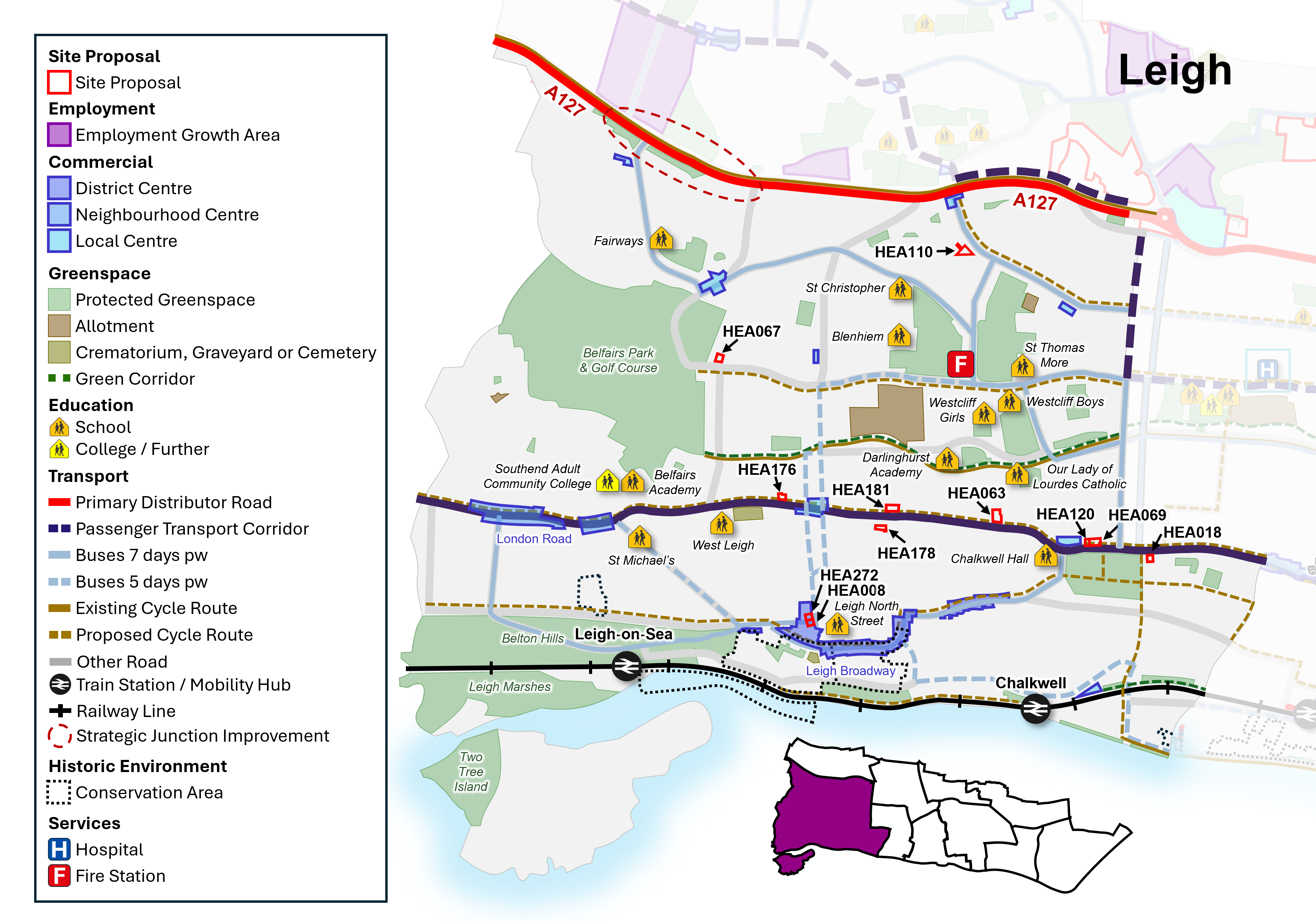
Neighbourhood Policy N2: Leigh
All development should be in accordance with the Development Plan for the city. Specific requirements for Leigh are:
Health and well-being
- New development must contribute to healthy lifestyles and address health and wellbeing having regard to Policy SP4.
- New development must be aligned with the provision of necessary infrastructure (including social infrastructure such as health and education) and not place a damaging burden on existing provision (Policy SP3). The Council will seek to protect and manage community facilities and sport and recreation facilities in line with Policies DM4.1 and DM4.2.
Homes
- Seek to safeguard existing dwellings, including family housing, and provide for new homes in line with Policy SP5, DM5.2, DM5.3 and DM5.4 and as per sites identified for residential development in Policy N2i (Policy Table N2i).
- Positively consider windfall development particularly where they are of good quality design and optimise the use of land along the A13 Key Passenger Transport Corridor and within District and Neighbourhood Centres.
Economy and Tourism
- Seek to manage employment land and promote economic growth, including at Leigh Port, in line with Policy SP6 and DM6.1.
- Manage and support the provision of Class E retail and commercial uses within Leigh District Centre, and the Neighbourhood and Local Centres, in accordance with the retail hierarchy, and improve accessibility in line with Policy DM6.4.
- Seek to manage and safeguard visitor accommodation, facilities and assets, including the foreshore, in line with Policy DM6.5, particularly around Leigh Old Town/ Leigh Port and Leigh District Centre.
Urban Design, Character and Heritage
- The Council will support good quality design that contributes positivity to the creation of successful places and optimises the use of land having regard to local character and context in line with Policy SP7 and DM7.1. Development along the seafront will have regard to Policy DM8.4 and Policy Table DM8.4: Seafront Character Zones (as defined on the Policies Map).
- The Neighbourhoods Conservation Areas and other heritage assets within the neighbourhood, will continue to be conserved and opportunities to enhance them encouraged, particularly where this would contribute to heritage-led regeneration (Policy DM7.6).
- Support public realm improvements and urban greening focused on Leigh District Centre, Neighbourhood and Local Centres, A13 Key Passenger Transport Corridor, Leigh and Chalkwell railway station and Seafront.
Natural Environment and Climate Change
- Protect and enhance the green and blue Infrastructure network within Leigh Neighbourhood, including protected green space, parks, and foreshore in line with Policy SP8, DM8.2, DM8.4.
- Establish an effective green grid including new and improved public green space.
- Promote enhancements to existing play space facilities and new facilities within the neighbourhood to improve quality and access.
- Manage and promote tree planting within new development as set out in Policy DM8.5, particularly within the south of the neighbourhood including along A13 Key Passenger Transport Corridor to contribute towards the 12-15% canopy cover target.
- Development should seek to avoid the risk of flooding, unless otherwise allocated for development, and incorporate sustainable urban drainage systems (SuDS) (Policy DM9.4).
Transport and connectivity
- Widen travel choice, particularly by walking and cycling, rail, bus (including a mobility hub at Leigh Station, enhancement of existing routes and new routes as part of the wider passenger transport network, and demand-responsive transport), car share/ clubs, and taxi in line with Policy SP10.3.
- Promote improvements to the A13 Key Passenger Transport Corridor, passenger transport corridor and wider passenger transport network (Figure N2).
- Enhance provision and quality of the neighbourhood's walking and cycle networks, including along the London Road and Leigh Broadway; the Charles III England Coast Path and National Cycle Network Route 16 (including Cinder Path) (Figure N2), and promote opportunities to enhance provision around schools, railway stations, district and neighbourhood centres.
- Proposals to enhance the setting and role of railway stations within Leigh neighbourhood will be supported in accordance with Policy DM10.4, promoting Leigh Railway Station as a Mobility Hub.
- Infrastructure for public electric vehicle charging points should be focussed within designated commercial/ retail centres and public car parks. On-street residential charging points should be located where they would not inhibit access for pedestrians and other road users.
Have your say…
Please explain your answer
QN2b: Do you agree with Neighbourhood Policy N2: Leigh? Please explain your answer.
12.11 The local plan designates land for particular purposes, such as to protect valuable green space and key employment areas. The plan also includes site proposals that identify specific sites for particular uses. This process ensures that land is utilised effectively and strategically and will guide development decisions on future planning applications across the city. See Appendix 2 and accompanying Policies Map for more information
Policy N2i: Leigh Site Proposals
- Within Leigh, allocate sites, as defined on the Policies Map, for development as set out in Policy Table N2i (see also Figure N2):
Policy Table N2i: Sites in Leigh
|
Reference Number |
Site Name |
Proposed Use |
Approx. Homes |
|
|
Proposed Allocation |
||||
|
HEA272 |
Former Police Station, Elm Road, Leigh-on-Sea |
Mixed use scheme with commercial/ community ground floor use providing active frontage, retaining locally listed façade with residential to rear and upper floors. |
5 |
|
|
HEA018 |
658 London Road, Leigh-on-Sea |
Mixed use residential development with commercial use at ground floor providing active frontage. Principle of development established through previous planning permission. |
25 |
|
|
HEA069 |
Former Car Showroom, 831-837 London Road, Leigh-on-Sea (north of Chalkwell Park) |
Mixed use residential development with commercial ground floor providing active frontage. |
52 |
|
|
HEA120 |
843 London Road, Leigh-on-Sea |
Mixed use residential development with commercial use at ground floor providing an active frontage. Principle of development established through previous planning permission. |
9 |
|
|
HEA178 |
986-1006 London Road, Leigh-on-Sea |
Mixed use residential development with potential for commercial ground floor providing active frontage. |
17 |
|
|
HEA110 |
Vacant Land to the rear of 11-33 Juniper Road |
Residential development, complemented by landscaping, green space and improved access. |
8 |
|
|
Site with planning permission to be allocated (Please note a planning permission cannot be rescinded as a result of this consultation) |
||||
|
HEA008 |
Sarah Moore, 57-59 Elm Road, Leigh-on-Sea |
Continued use as public house with residential development to upper floors. |
6 |
|
|
HEA063 |
939-953 London Road, Leigh-on-Sea |
Mixed use residential development with commercial ground floor providing an active frontage. |
30 |
|
|
HEA067 |
Former Old Vienna Restaurant, Eastwood Road, Leigh-on-Sea |
Residential development, complemented by landscaping. |
13 |
|
|
HEA176 |
1285 London Road, Leigh-on-Sea |
Mixed use residential development with commercial ground floor providing active frontage. |
17 |
|
|
HEA181 |
1131-1111 London Road, Leigh-on-Sea |
Residential development with commercial ground floor providing active frontage. |
6 |
|
Have your say…
Please explain your answers
QN2c: Do you agree with Neighbourhood Policy N2i: Leigh Site Proposals? Please explain your answer providing the site reference where applicable.
12.3 Prittlewell
Prittlewell Area Profile
Context and Key Issues
- Prittlewell has a notable historic core, centred on the parish church of St. Mary and the medieval road alignments of East Street/ West Street and North Street (now part of Victoria Avenue). It is adjacent to Southend Central Area to the south.
- The village of Prittlewell was once the principal settlement and parish in the area now covered by the City of Southend-on-Sea. The neighbourhood is home to a range of heritage assets, including Prittlewell Conservation Area, the Grade I listed St Mary's Church, and the Grade I listed Prittlewell Priory and Scheduled Monument in Priory Park.
- Priory Park provides an important area of public green space within the neighbourhood, including sports facilities, band stand, fishing lake and children's play area, complemented by provision at St Laurence Park to the west of the neighbourhood.
- Prittle Brook Greenway provides pedestrian/ cycle connections to the neighbourhood from the west.
- Key destinations within the neighbourhood include Southend University Hospital (Prittlewell Chase), Southend United Football Club (Roots Hall), Priory Park, and London Southend Airport lies just to the north within Rochford District Council.
- There are five Local Centres within the Neighbourhood as well as retail parks near to the Airport and at Thanet Grange (Tesco A127).
- There are two Air Quality Management Areas (AQMAs) within Prittlewell - The Bell Junction AQMA, and AQMA 2 at a short section of the A127 Victoria Avenue, close to the junctions with East Street, West Street, Priory Crescent and Fairfax Drive.
- Cuckoo Corner is also a busy junction, providing links between the primary distributor of the A127 Victoria Avenue and Prince Avenue, London Southend Airport and neighbouring areas – including the A1159 which provides connections to Southchurch, Fossetts, Shoeburyness and other settlements to the east.
- There is an important local employment base, with two employment areas (Priory Works and Thanet Grange).
- The area has a main line railway station (Prittlewell) and bus connections to the City Centre, London Southend Airport and beyond.
Vision
12.12 Prittlewell's heritage assets and green spaces continue to play an important role in defining its character. Parks and open spaces, and connections between them, have been enhanced, together with play area provision, and landscaping and tree cover increased as part of improvements to the wider green infrastructure network. Walking and cycling links, including connections to Prittle Brook Greenway and with neighbourhoods to the east, are improved.
12.13 Air quality will be improved, particularly within the Air Quality Management Areas (AQMAs) at the Bell and West Road/ East Street junctions of the A127 and at Cuckoo Corner, through design and landscape mitigation, that enhances the quality of the environment and mitigates the impact of traffic. The impact of the road network on the character and setting of heritage assets has been mitigated wherever possible.
12.14 Victoria Avenue (A127) continues to play an important role as the primary distributor, and passenger transport corridor, providing access to the City Centre and Central Seafront, and connections to London Southend Airport. Southend University Hospital continues to serve the local and wider area, served by a range of travel options, including bus services, and improved opportunities for walking and cycling.
12.15 The economic role of London Southend Airport is supported and improved surface access for all transport modes will serve the Airport and London Southend Airport Railway Station. The employment areas of Priory Works and Thanet Grange continue to be protected for employment uses to support local employment opportunities. Opportunities for residential growth are focussed around passenger transport corridors, allowing for sustainable access.
Have your say…
Please explain your answers
QN3a: Do you agree with the Vision for Prittlewell? Please explain your answer.
Figure N3: Prittlewell Neighbourhood
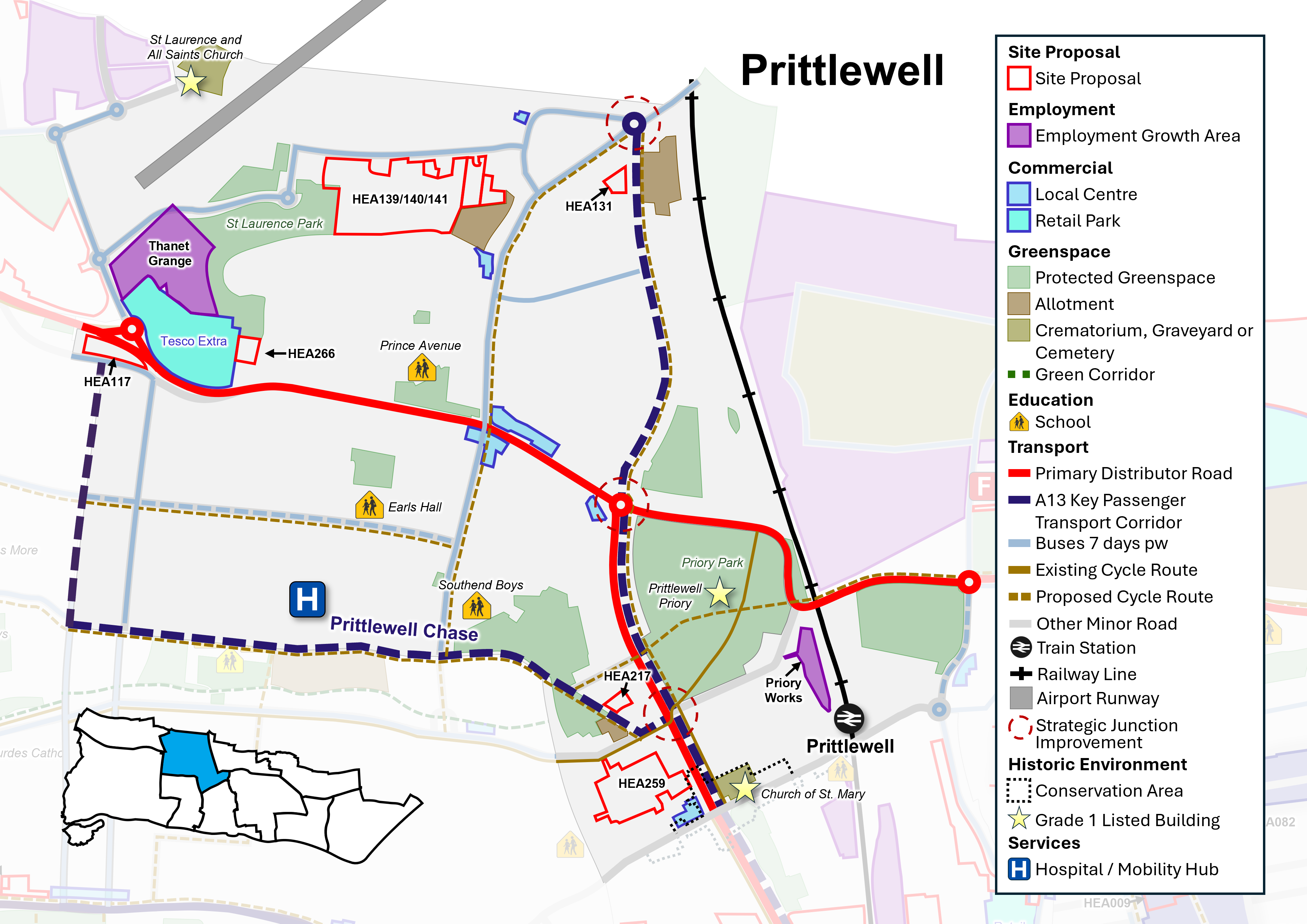
Neighbourhood Policy N3 – Prittlewell
All development should be in accordance with the Development Plan for the city. Specific requirements for Prittlewell are:
Health and well-being
- New development must contribute to healthy lifestyles and address health and wellbeing having regard to Policy SP4.
- New development must be aligned with the provision of necessary infrastructure (including social infrastructure such as health and education) and not place a damaging burden on existing provision (Policy SP3). The Council will seek to protect and manage community facilities and sport and recreation facilities in line with Policies DM4.1 and DM4.2.
- Opportunities for urban greening along the A127 primary distributor will be encouraged to enhance the local environment and help to improve local air quality and enhance quality of life for residents, particularly in Air Quality Management Areas (AQMAs)* and at Cuckoo Corner.
Homes
- Seek to safeguard existing dwellings, including family housing, and provide for new homes in line with Policy SP5, DM5.2, DM5.3 and DM5.4 and as per sites identified in Policy N3i (Policy Table N3i).
Economy and Tourism
- Seek to manage employment land and promote economic growth in line with Policy SP6 and DM6.1.
- Protect and promote the provision of additional employment floorspace within identified employment areas in line with Policy DM6.3, including within the employment growth area of Thanet Grange and the industrial/ business estate at Priory Works.
- Manage and support the provision of Class E retail and commercial uses in accordance with the retail hierarchy within identified Local Centres and improve accessibility in line with Policy DM6.4.
- Support the refurbishment and renewal of Roots Hall stadium, including improved surface access by public transport and provision for walking and cycling, and enhanced public realm, linked to development at Fossetts Farm (site HEA264, see Fossetts Neighbourhood).
Urban Design, Character and Heritage
- The Council will support good quality design that contributes positivity to the creation of successful places and optimises the use of land having regard to local character and context in line with Policy SP7 and DM7.1.
- Prittlewell Conservation Area and other heritage assets within the neighbourhood will continue to be conserved and opportunities to enhance them encouraged, particularly where this would contribute to heritage-led regeneration (Policy DM7.6). Areas of archaeological potential in the neighbourhood should be taken account of within any development proposals (Policy Table DM7.6a).
- Support public realm improvements and urban greening focused to Local Centres and Mobility Hubs.
Natural Environment and Climate Change
- Protect and enhance the green and blue Infrastructure network within Prittlewell Neighbourhood, including protected green space and parks, in line with Policy SP8, DM8.2.
- Establish an effective green grid, including new and improved public green space.
- Promote enhancements to existing play space facilities and new facilities within the neighbourhood to improve quality and access.
- Manage and promote tree planting within new development as set out in Policy DM8.6, particularly within St Laurence ward, to contribute towards the 12-15% tree canopy cover target.
- Development must seek to avoid the risk of flooding, unless otherwise allocated for development, and incorporate sustainable urban drainage systems (SuDS) (Policy DM9.4).
Transport and connectivity
- Widen travel choice, particularly by walking and cycling, rail, bus (including Mobility Hubs at Southend University Hospital and London Southend Airport, enhancement of existing routes and new routes as part of the wider passenger transport network, and demand-responsive transport), car share/ clubs, and taxi in line with Policy SP10.3.
- Promote improvements to the bus network, including the passenger transport corridor between the City Centre and London Southend Airport, and to Southend University Hospital.
- Promote opportunities for improvements to walking and cycling networks, particularly at Southend University Hospital and between London Southend Airport and the City Centre (see Figure N3).
- Proposals to enhance the setting and role of Prittlewell railway station will be supported in accordance with Policy DM10.4.
- Manage and support the development of London Southend Airport as a sub-regional transport and economic hub, including improved surface access measures to encourage and enable people to travel to the airport using public transport and active travel in line with Policy SP11.
- Infrastructure for public electric vehicle charging points should be focussed within Local Centres and public car parks. On-street residential charging points should not inhibit access for pedestrians and other road users.
*AQMA 1 The Bell Junction; AQMA 2 A127 Victoria Avenue/ East Street/ West Road
Have your say…
Please explain your answers
QN3b: Do you agree with Neighbourhood Policy N3: Prittlewell? Please explain your answer.
12.16 The local plan designates land for particular purposes, such as to protect valuable green space and key employment areas. The plan also includes site proposals that identify specific sites for particular uses. This process ensures that land is utilised effectively and strategically and will guide development decisions on future planning applications across the city. See Appendix 2 and accompanying Policies Map for more information.
Policy N3i: Prittlewell Site Proposals
- Within Prittlewell, allocate sites, as defined on the Policies Map, for development as set out in Policy Table N3i (see also Figure N3 and policies map):
Policy Table N3i: Sites in Prittlewell
|
Ref No |
Site Name |
Proposed Use |
Approx. Homes |
|
Allocation |
|||
|
HEA117 |
Land between Prince Avenue and A127 (former cattery) |
Residential development, complemented by landscaping and provision of green buffer between the rear of the site and Prince Avenue (A127). |
29 |
|
HEA131 |
St Stephen's Church, Manners Way |
Retain church and supporting community use, play area, and potential for complementary residential uses. |
7 |
|
HEA217 |
Land at Prittlewell Chase, adjacent to Brook Meadows House |
Residential development (potential for extra care/ assisted living/ key worker accommodation) complemented by landscaping. |
31 |
|
HEA259 |
Roots Hall Stadium |
Renovation of Roots Hall Football Stadium to provide a modern community stadium with complementary food and drink uses, with potential for some enabling residential development. |
Unknown |
|
Broad Location/ Opportunity Site |
|||
|
HEA139, HEA140A, HEA140B, HEA141 |
Land to the South of Eastwoodbury Lane |
Potential for new school (HEA141) as required and residential development, together with improved access, enhanced public space, and allotment provision. Part of site (HEA140A) has planning permission. |
Unknown (subject to school provision) |
|
HEA266 |
Prince Close |
Potential redevelopment including residential, with landscaping, particularly to western boundary adjacent to commercial uses. |
Unknown |
Have your say…
Please explain your answers
QN3c: Do you agree with Neighbourhood Policy N3i: Prittlewell Site Proposals? Please explain your answer providing the site reference where applicable.
12.4 Westcliff
Westcliff Area Profile
Context and Key Issues
- Westcliff neighbourhood lies between Leigh to the west and Southend Central to the east. It stretches from the coast to Prittle Brook and is bisected by the A13 London Road.
- The London Road marks a change in street pattern and defines the distinctive Westborough residential area in the northern part of the neighbourhood, a tightly knit grid pattern of terraced Victorian and Edwardian housing. The southern part of the neighbourhood contains a mixture of mainly Victorian and Edwardian residential streets with some larger properties particularly along the seafront route, including high rise flats.
- Heritage assets are clustered around the Seafront and Hamlet Court Road, along with some individual listed buildings including the Palace Theatre.
- Westcliff has the highest population density in the city, with around 46 homes per hectare. It developed largely during the Victorian and Edwardian eras, with terraced and semi-detached homes, and many properties have been sub-divided into multiple flats. In places this has resulted in a lack of private garden space, and reduced space for adequate and convenient waste storage.
- Westcliff is a walkable neighbourhood with good access to day-to-day services. Retail and commercial functions are focussed on the District Centre of Hamlet Court Road, and Neighbourhood Centre at London Road/ West Road. A lot of retail and commercial activity is centred on linear main road corridors, mostly comprising shops and other small businesses.
- The A13 London Road is the key passenger transport corridor, providing regular bus services to and from Southend City Centre. Westcliff railway station provides connections to Southend and London, but Prittlewell railway station is also within a reasonable walking distance for many residents living in the neighbourhood. Bus services are also available via Southend University Hospital to Leigh-on-Sea. Reflecting its good public transport accessibility and access to local services, Westcliff has the second lowest car ownership in the city.Census 2021 took place during covid restrictions and therefore some caution should be applied in relation to travel statistics www.ons.gov.uk/peoplepopulationandcommunity/populationandmigration/populationestimates/methodologies/qualityandmethodologyinformationqmiforcensus2021#quality-summary ; ;
- There is a lack of green space within the neighbourhood apart from Fairfax Drive playground. Residents use public open space outside the neighbourhood at Chalkwell Park, Priory Park and Gainsborough Park, and the seafront provides recreational opportunities. ;
- Tree canopy cover is the lowest in the city at 8.5% and opportunities to increase this should be considered as part of any development proposals. ;
- Public realm is poor in places and would benefit from enhancement to improve amenity and opportunities for active travel.
Vision
12.17 Westcliff will continue to be a vibrant and accessible neighbourhood, with goods and services and local employment within easy reach for residents. Its community and cultural assets will be protected and strengthened. Westcliff District Centre at Hamlet Court Road remains the focus for everyday activity, along with the Neighbourhood Centre at London Road/ West Road, complemented by Local Centres and businesses along the A13 London Road. The A13 will remain the Key Passenger Transport Corridor, with an enhanced public realm, and will be a focus for residential growth, providing well designed buildings that optimise the use of land, with opportunities for active ground floor uses and residential uses above.
12.18 Its heritage assets will be conserved and enhanced, including Hamlet Court Road Conservation Area, providing a focus for heritage-led regeneration and enterprise. The traditional character of the seafront, including historic and natural assets, will be protected and enhancedDevelopment along the seafront will have regard to Policy DM8.4 and Policy Table DM8.4: Seafront Character Zones..
12.19 The quality of the urban realm within the neighbourhood will be improved, making it more attractive for active travel, particularly around retail/ commercial centres and schools, and to facilities and services outside the neighbourhood, for example, Milton Gardens, Chalkwell Park and Priory Park. Opportunities to provide urban greening and enhance biodiversity will help improve air quality, increase climate resilience, and provide for an improved quality of life for residents. Opportunities will be sought to provide new and enhanced public open space and play facilities.
Have your say…
Please explain your answers
QN4a: Do you agree with the Vision for Westcliff? Please explain your answer.
Figure N4: Westcliff Neighbourhood
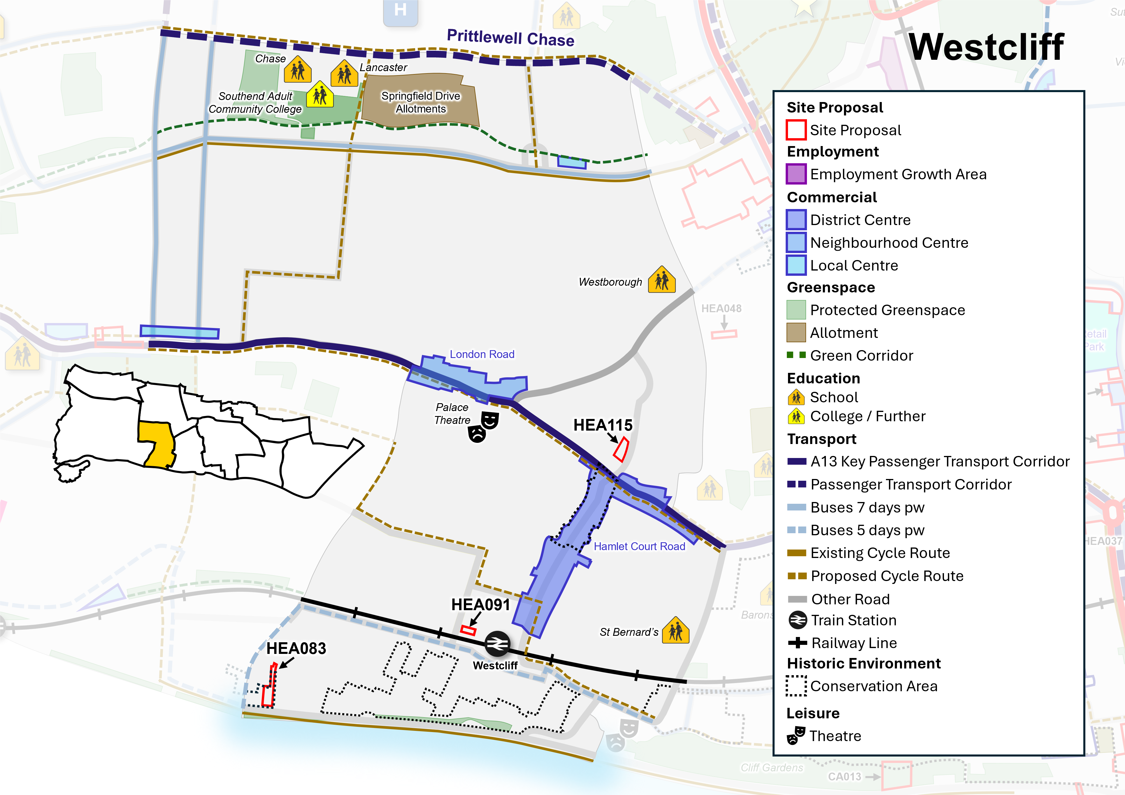
Neighbourhood Policy N4: Westcliff
All development should be in accordance with the Development Plan for the city. Specific requirements for Westcliff are:
Health and well-being
- New development must contribute to healthy lifestyles and address health and wellbeing having regard to Policy SP4.
- New development must be aligned with the provision of necessary infrastructure (including social infrastructure such as health and education) and not place a damaging burden on existing provision (Policy SP3). The Council will seek to protect and manage community facilities and sport and recreation facilities in line with Policies DM4.1 and DM4.2.
Homes
- Seek to safeguard existing dwellings, including family housing, and provide for new homes in line with Policy SP5, DM5.2, DM5.3 and DM5.4 and as per sites identified in Policy N4i (Policy Table N4i).
- Positively consider windfall development particularly where they are of good quality design and optimise the use of land along the A13 Key Passenger Transport Corridor and within District and Neighbourhood Centres.
- Ensure that an appropriate balance is struck between meeting the demand for homes in multiple occupation whilst protecting and safeguarding the character and amenities of established residential areas in line with Policy DM5.6.
Economy and Tourism
- Manage and support the provision of Class E retail and commercial uses in accordance with the retail hierarchy within Westcliff District Centre, London Road/ West Road Neighbourhood Centre, and the Local Centres, and improve accessibility in line with Policy DM6.4.
- Seek to manage and safeguard visitor accommodation, facilities and assets, including the foreshore, in line with Policy DM6.5.
Urban Design, Character and Heritage
- The Council will support good quality design that contributes positively to the creation of successful places and optimises the use of land having regard to local character and context in line with Policy SP7 and DM7.1. Development along the seafront will have regard to Policy DM8.4 and Policy Table DM8.4: Seafront Character Zones (as defined on the Policies Map).
- The Neighbourhood's Conservation Areas and other heritage assets within the neighbourhood will continue to be conserved and opportunities to enhance them encouraged, particularly where this would contribute to heritage led regeneration (Policy DM7.6).
- Support public realm improvements and urban greening focused around Westcliff District Centre, Neighbourhood and Local Centres, A13 Key Passenger Transport Corridor, Transport Hubs and Seafront.
Natural Environment and Climate Change
- Protect and enhance the green and blue Infrastructure network within Westcliff, including protected green space, parks and foreshore, in line with Policies SP8, DM8.2, and DM8.4.
- The character and function of the foreshore and related open space and leisure uses will be protected, and measures for climate change adaptation and mitigation should incorporate nature-based solutions, in accordance with Policy DM9.4.
- Establish an effective green grid with new and improved public green space and enhanced active travel connections to neighbouring parks and open space at Chalkwell Park and Priory Park.
- Provide new and enhanced play space within the neighbourhood to improve quality and access.
- Manage and promote tree planting within new development as set out in Policy DM8.6.
- Development should seek to avoid the risk of flooding, unless otherwise allocated for development, and incorporate sustainable urban drainage systems (SuDS) (Policy DM9.4)
Transport and connectivity
- Promote improvements to the A13 Key Passenger Transport Corridor.
- Widen travel choice, particularly by walking and cycling, rail, bus (including the enhancement of existing routes and new routes as part of the wider passenger transport network, and demand-responsive transport), car share/ clubs, and taxi in line with Policy SP10.3.
- Promote opportunities to enhance walking routes along London Road between Hamlet Court Road and West Road, and cycling corridors (Figure N4).
- Proposals to enhance the setting and role of Westcliff railway station will be supported in accordance with Policy DM10.4.
Have your say…
Please explain your answers
QN4b. Do you agree with Neighbourhood Policy N4: Westcliff? Please explain your answer.
12.20 The local plan designates land for particular purposes, such as to protect valuable green space and key employment areas. The plan also includes site proposals that identify specific sites for particular uses. This process ensures that land is utilised effectively and strategically and will guide development decisions on future planning applications across the city. See Appendix 2 and accompanying Policies Map for more information.
Policy N4i: Westcliff Site Proposals
- Within Westcliff, allocate sites, as defined on the Policies Map, for development as set out in Policy Table N4i (see also Figure N4):
Policy Table N4i: Sites in Westcliff
|
Ref No |
Site Name |
Proposed Use |
Approx. Homes |
|
Broad Location/Opportunity Site |
|||
|
HEA091 |
Land at Westcliff Station (adj Valkyrie Road) |
Potential for residential development with landscaping. |
12 |
|
HEA115 |
Part of Hamlet Court Road Car Park |
Potential for residential development subject to operational requirements for public parking. |
10 |
|
Site with planning permission to be allocated (Please note a planning permission cannot be rescinded as a result of this consultation) |
|||
|
HEA083 |
30-32 The Leas |
Residential development, providing opportunity for well-designed development that contributes to and conserves and enhances the character and setting of the Crowstone Conservation Area. |
9 |
Have your say…
Please explain your answers
QN4c: Do you agree with Neighbourhood Policy N4i: Westcliff Site Proposals? Please explain your answer providing the site reference where applicable.
12.5 Southend Central
Southend Central Area Profile
General Character
12.21 Southend Central is characterised by two distinct entities, the City Centre (which includes the High Street) and the Central Seafront area comprising the city's main tourism facilities and leisure offer. It is also home to surrounding residential areas, including Sutton Road, Clifftown, Milton and Shorefields. These distinct areas are shown on Figure N5.i, and the policy framework is set out in Policies N5a, N5b and N5c respectively, with Policy N5d setting out the approach to car parking management in Southend Central Area. Proposed site allocations and opportunity areas are presented in Policies N5ai, N5bi, and N5ci.
City Centre
12.22 Southend City Centre is a sub-regional retail and commercial centre, traditionally dominated by comparison shopping including two retail malls ('The Victoria's Centre' and 'The Royals') at the northern and southern ends of the linear pedestrianised High Street, which form part of the City Centre Primary Shopping Area. There is a continuous link through to the Central Seafront area, via Pier Hill. It is also the principal public transport hub for the city and includes two railway stations (Southend Central and Southend Victoria) and the bus station/ travel centre interchange at Tylers Avenue/ Chichester Road.
The City Centre is comprised of three zones (see Figure N5.i which shows the City Centre 'zones' in context with the other parts of the Southend Central Area neighbourhood), all of which are intersected by the High Street:
-
City Centre (North) (Gateway) which includes The Victoria's, the north end of the High Street Better Queensway, Chichester Road, London Road, Victoria Avenue and residential and employment uses to the east of the railway line/ west of Sutton Road:
12.23 To the western edge of City Centre (North) (Figure N5.i), the end of the London Road provides links to the northern extent of the High Street, and is home to student accommodation, supermarket and a cluster of eating and drinking establishments. This area has benefitted in recent years from public realm enhancements, which have created an attractive and inviting public space, there are some bulky and taller buildings in this location, and commercial uses at ground floor (some residential above ground floor). The northern end of the High Street (including primary shopping area) is dominated by The Victoria's shopping centre, a focus for retail, leisure, health and other commercial uses, with potential to grow this focus. The tower block element above the centre has been converted to residential. To the east is Chichester Road, which connects this area through to Warrior Square and the bus interchange at Tylers Avenue but would benefit from enhancements to create a green route, improving connections to the High Street and bus interchange, and enhancing the setting of the Better Queensway site to the east. Currently a surface car park, high rise residential tower, commercial uses and the busy Queensway dual carriageway dominate this area, which offer potential for regeneration. Southchurch Road provides commercial frontages, some with residential above.
12.24 The Short Street area to the north-east of the High Street includes elements of employment land, as well as a range of residential development types. Grainger Road area provides opportunity for regeneration. To the north-west of the High Street is a grouping of bulky post-war civic buildings situated on the eastern side of Victoria Avenue. The western side of Victoria Avenue has seen the conversion of several tall buildings (obsolete office blocks) into residential use, some with active commercial uses at ground floor, and may present opportunity for further residential-led regeneration and a focus for taller buildings.
- City Centre (Central) (Educational Hub) which includes High Street, Elmer Square, Warrior Square and Gardens, Chichester Road:
12.25 Southend Central Railway Station is in the Central zone of the City Centre (Figure N5.i) and sits adjacent to the University of Essex and South Essex College campuses, and The Forum complex, which forms part of the academic hub as well as accommodating the public library and art gallery. Buildings on the western side of the High Street back onto the green space and play area that are situated in front of The Forum. There is limited permeability through to the High Street from this area, which remains hidden behind existing buildings. In the central zone, the pedestrianised High Street is wider in places, narrowing where it is bisected by the railway line, which crosses over the High Street via a railway bridge. The High Street forms part of the Primary Shopping Area. There are some attractive, historic shopfronts in this section of the High Street, and there have been some public realm enhancements to adjoining side streets although there remains opportunity to enhance visibility and links to The Forum and educational hub, to Southend Central Station (including enhancements to the forecourt to improve access and appearance), and to the green space at Warrior Square Gardens.
12.26 The Warrior Square Conservation Area to the east of the High Street is a residential community set around tree-lined open space, Warrior Square Gardens. To its western edge is Chichester Road, which connects Queensway to the north with the travel centre at Tylers Avenue to the south and has potential for enhancement to create an attractive green street along its length, connecting to the south and northern City Centre zones.
- City Centre (South) (Shops to Coast) which includes the southern end of High Street, Tylers, The Royals, Alexandra Street/ Clarence Road, Market Place and Royal Mews:
12.27 The City Centre (South) zone (Figure N5.i) provides the link between the High Street and the Central Seafront area; via Pier Hill there is a continuous link to the seafront. The Royals shopping centre is a focal point at the end of the High Street, although presents a blank frontage at upper floors fronting the estuary. The High Street itself is narrower here, and pedestrianised to the south, with retail and commercial units, and eateries, providing activity. Further north, the High Street is intersected by the local road network, which allows traffic around part of it. Alexandra Street and Clarence Road provide surface car parks within this zone, close to the High Street and Central Seafront. Alexandra Street provides a link between the High Street and Central Seafront (to the west) and to a notable part of the Central Area's historic core to the west, connecting through to the Clifftown Conservation Area. To the east of the High Street is Tylers Avenue, including surface level car park and travel centre. There are opportunities to enhance provision here and improve pedestrian links through to the High Street, including through public realm and urban greening enhancements.
Central Seafront area
12.28 The Central Seafront area lies to the south of the City Centre from the cliff line to the foreshore (see Figure N5.i). It includes an extensive range of leisure and tourist facilities focussed along Western and Eastern Esplanade and Marine Parade including the historic Pier, Kursaal and Adventure Island theme park. The City Beach (Phase 1) scheme has revitalised a key part of the central seafront, with key enhancements made to the public realm while further investment in attractions and tourism accommodation have increased the quality of leisure facilities and capacity of the hotel offer. The cliffs along Western Esplanade provide a green backdrop to the seafront with the Cliffs Pavilion, a major regional theatre, situated at its western end. To the east of the Central Seafront area is the Grade II listed Kursaal (part of the Kursaal Conservation Area) with Eastern Esplanade also providing a focus for leisure and tourism, as well as being home to the Eastern Esplanade Conservation Area.
Surrounding residential areas
12.29 The Southend Central neighbourhood is also home to several well-established surrounding residential areas (Figure N5.i). These areas typically contain more suburban type terraced housing, as well as social housing estates and some taller residential buildings. These taller buildings are largely focused to the western extent of Southend Central Area, with several residential tower blocks and more tightly planned residential streets around the North Road area; to the south of this area is the London Road retail park.
12.30 To the east, Sutton Road includes a mixture of shops and commercial/ industrial premises, living above shops, and residential properties (including flatted development/ apartment blocks, at four-five storeys) and provides a focus for well designed, residential led regeneration. The Greyhound Way retail park is accessed from Sutton Road, providing larger format units. South of here, to the south and east of Warrior Square, there is a cluster of residential streets, including Quebec Avenue and York Road, comprising mainly terraced properties, adjoining Queensway to the east. Beyond this, towards the seafront, the Kursaal (Woodgrange) estate is located to the eastern edge of the Southend Central Area, a 1970s social housing development comprising residential blocks, interspersed with green spaces and landscaping. Victoria Road marks the eastern extent of Southend Central here, with terraced residential streets relatively typical of Southend, and some more contemporary residential development including houses and five storey apartment blocks focused around Retort Close.
12.31 The area to the south-west of the High Street marks the early expansion of Southend's residential neighbourhoods and forms an historic core with some particularly attractive planned streets and spaces in the Clifftown Conservation Area, including Prittlewell Square and Westcliff/ Clifftown Parade Gardens. Beyond this, to the north are tightly planned residential streets close to the City Centre, leading to the leafy, curving residential streets within the Milton Conservation Area, and the residential streets of the Shorefields Conservation Area, with views across the estuary, and prominent, taller buildings, including the Westcliff Hotel (as well as adjacent taller residential buildings, outside of the Conservation Area).
Figure N5.i: Southend Central 'zones'
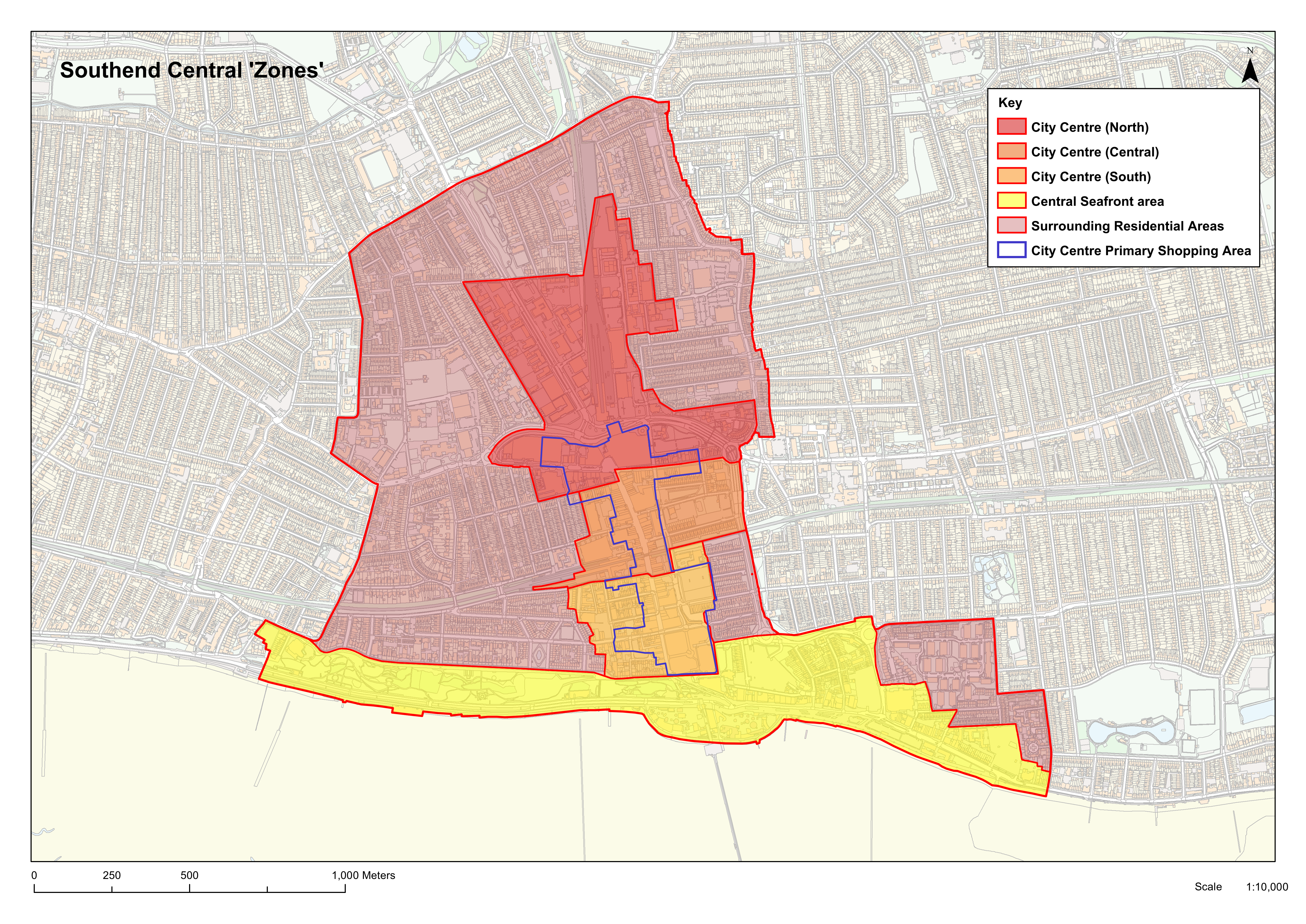
Challenges and Opportunities
12.32 There are several challenges facing Southend Central Area and opportunities for addressing these in a positive sustainable manner. These include:
- the need to regenerate the High Street following the national decline in the traditional comparison goods retail function in town centres due to changing shopping patterns;
- opportunities to regenerate the Queensway area to the north-east of the High Street as a residential-led community project that will be better integrated with the City Centre;
- identifying opportunities for new housing development at higher densities within the neighbourhood focussed to the City Centre and Central Seafront that will assist regeneration and meet a range of local housing needs, including for families, younger and older residents;
- further regeneration of the Central Seafront area to provide opportunities to enhance leisure and tourism, providing a year-round destination and enhancing visitor accommodation;
- improving transport and travel choices, including for walking and cycling, public transport and enhance access to public parking to support the economic vitality of the area;
- securing heritage led regeneration of key assets including the Pier and Kursaal and enhancing the unique character and identity of its conservation areas;
- enhancing and improving the public realm and green spaces, including greening of the High Street and adjoining routes;
- protecting and enhancing the natural assets of the foreshore.
Vision
12.33 In the light of changing retail patterns and the need to move from a retail policy approach to promoting a greater mix of uses, the City Centre needs to be re-imagined and refocused to ensure that it adapts and evolves to retain its role as a vibrant thriving sub-regional centre. An integral part of this regeneration approach will be enhancing the tourism and leisure potential of the Central Seafront area, as well as making it an attractive place to live and work, improving connections with surrounding residential areas. Building on the principles established in the Southend Central Area Action Plan and the findings of the City Strategy and Investment Plan, a specific vision for Southend Central setting out what we want the area to look like in twenty years' time is set out below. This provides the basis for specific local neighbourhood objectives and policy approaches set within the framework of the plans' wider strategic objectives and policies.
'Regeneration and the reinvention of the City Centre with improved links to the Central Seafront has provided for a prosperous and thriving commercial centre, resort and residential area. It will be an area that is vibrant, safe and hospitable, rich in heritage, commerce, learning, arts, culture and the creative industries and an attractive, diverse place where people want to live, work and visit for both day trips, overnight and longer stays. Its iconic Pier will be the focus of a thriving tourism industry reflecting Southend's status as one of the country's favourite coastal destinations'.
12.34 The objectives for Southend Central Area are:
- To improve and transform the economic vitality, viability and diversity of Southend Central Area by encouraging the establishment of a wider range of homes, businesses, shops and cultural uses whilst providing new opportunities for learning, creative industries, arts, recreation, leisure and tourism.
- To increase the number and diversity of people living within Southend Central Area by building more homes and ensuring that living in the area becomes appealing to more families with children, students, and older people supported by social and community infrastructure, and good access to public transport. Optimising the use of land in a sustainable manner, including through increasing densities, and opportunities for well-designed, sustainable tall buildings in appropriate locations.
- To encourage the establishment and expansion of businesses in Southend Central Area by identifying, promoting or actively bringing forward suitable sites for development to meet modern user and investor requirements.
- To promote and enhance the tourism, cultural and leisure offer within Southend Central Area, with a particular focus on the Central Seafront area, including visitor accommodation, having regard to the assets offered by the area, to attract greater visitor numbers and promote more overnight and longer stays.
- To support the viability and vitality of City Centre, including focus on the High Street and Primary Shopping Area, so that it remains the primary focus of regeneration and growth within Southend and creates an environment that encourages investment within the area.
- To promote Southend Central Area as a thriving learning quarter that provides state-of-the-art facilities and well-designed student accommodation.
- To improve accessibility to, from and within the area, ensuring streets, public and green spaces are well-connected, well-designed and safe, utilising a coordinated palette of materials and furniture that enhances the quality of the streetscape and improves opportunities for walking and cycling, and access to more sustainable modes of transport, such as rail and bus.
- To promote a positive approach to public car parking provision that provides public car parking levels that support the vitality and viability of the City Centre and Central Seafront Area, managing the balance of parking provision to address peak demand and capacity, and provide good access to the seafront by encouraging improvements to the quality of access to and from parking areas that are convenient, well-signposted, safe and secure.
- To enhance the quality of, and access to the area's natural environment and open spaces, connecting to the green grid, and to improve connectivity between the City Centre and Central Seafront Area, and surrounding residential neighbourhoods, in order to relieve pressure on the foreshores Site of Special Scientific Interest (SSSI), Ramsar site, Special Protection Area (SPA) and other environmental designations, to protect and enhance local biodiversity and nature conservation, and to encourage opportunity for linked trips.
Have your say…
Please explain your answers
QN5. Do you agree with the Vision and Objectives for Southend Central? Please explain your answer.
Figure N5.ii: Southend Central Neighbourhood
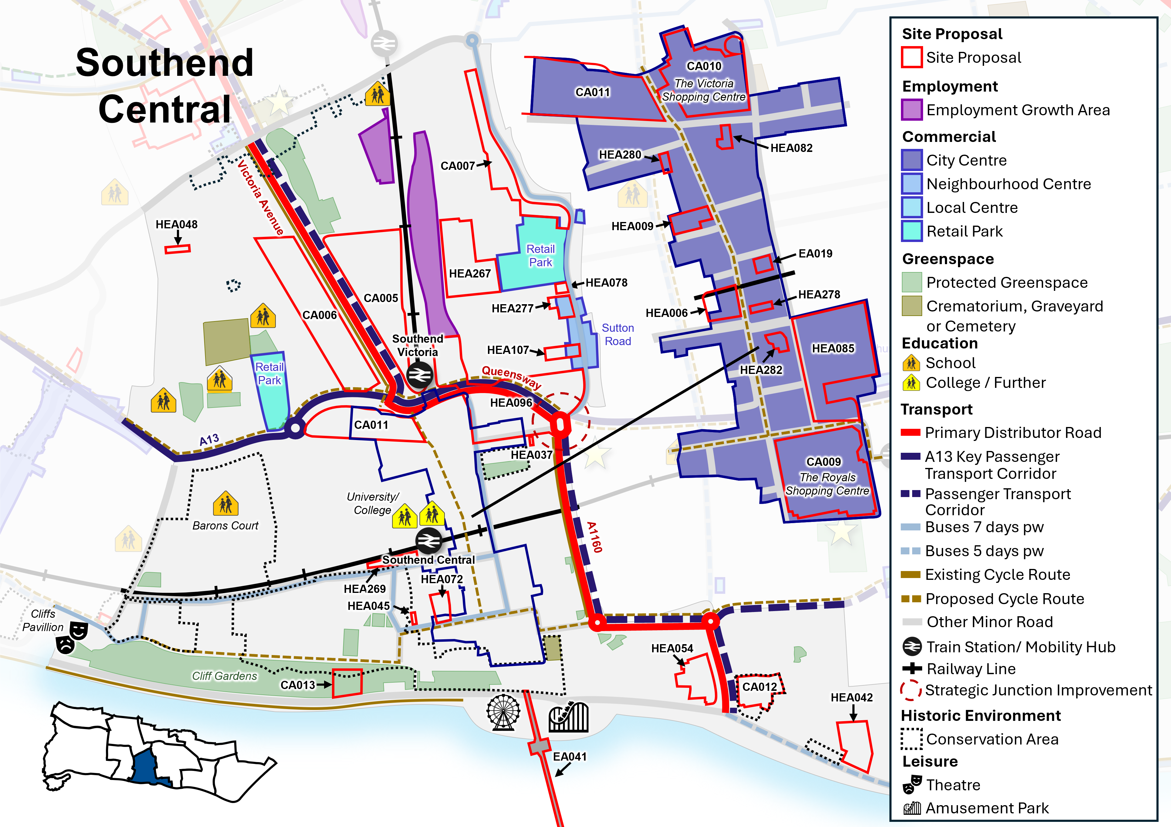
Policy Approach
12.35 The detailed Policy Approach for the Southend Central Area Neighbourhood is set out in Policies: N5a (City Centre) and N5ai (City Centre Site Proposals); N5b (Central Seafront area), N5bi (Central Seafront Site Proposals); N5c (Southend Central surrounding residential areas), and N5ci (Southend Central surrounding residential areas site proposals). In addition, Policy N5d (Traffic Management and Car Parking Provision in Southend Central) relates to the retention of key visitor car parking in the City Centre to ensure an adequate level of car parking is provided to support the vitality and viability of the city's commercial and tourism function.
12.36 All these policies should be read in conjunction with the relevant strategic and development management policies contained in this Local Plan. Strategic Policy SP2 (Spatial Strategy) identifies Southend Central Area as the primary growth area within the City for new homes and jobs. There is opportunity to optimise the use of land within Southend Central, including potential to increase densities, which could include the development of well designed, sustainable tall buildings in the City Centre and Central Seafront (see Policy DM7.3: Tall Buildings). The City Centre is also identified as the first preference for retail and other main town centre uses, and the Central Seafront as the primary focus for new and enhanced tourist attractions, complemented by opportunities within the City Centre.
City Centre – zones and potential themes
12.37 The City Centre is considered as a series of 'zones' – City Centre (North), City Centre (Central), and City Centre (South) (see Figure N5.i). Each of these zones has its own role and identity. The City Centre Primary Shopping Area spans all three of these zones. The following section provides more detail on the objectives for the City Centre.
- City Centre (North): Gateway
Victoria Avenue (including Southend Victoria Railway Station), Short Street, the northern extent of Queensway (including Better Queensway and Southchurch Road), London Road, and the northern end of the High Street (including The Victoria's shopping centre).
-
- Support high quality urban living centre around Victoria Avenue, Victoria Station and Queensway as a gateway to the City Centre.
- Consolidate Southend Victoria rail station as a successful transport hub and interchange maintaining a high-quality public realm and way finding through to the High Street and primary shopping area.
- Pivot to a more local community focused centre at the northern end of the High Street with a higher proportion of convenience retail complimented by numerous services and restaurants anchored by the cinema.
- City Centre (Central): Educational Hub
The Forum/ Elmer Square, Warrior Square, and the central section of the High Street.
-
- Develop the education and learning culture focussed around The Forum and that part of the High Street, with a higher proportion of smaller independent outlets and cafes.
- Warrior Square will provide a tranquil contrast to the vibrant High Street area, focused on the predominantly small-scale residential character of the Conservation Area and the green quality of Warrior Square Gardens.
- Enhance the appearance and setting of the Southend Central Railway Station forecourt, conserving the setting of the locally listed station building, together with improved pedestrian links across the station and to the High Street including landscaping, tree planting and public realm improvements.
- City Centre (South): Shops to Coast
Tylers, southern end of the High Street (including The Royals Shopping Centre), Alexandra Street/ Clifftown.
-
- Consolidate larger format national retail chains to the southern section of the High Street with improved linkages to the central seafront.
- Revitalise The Royals Shopping Centre through high quality mixed-use development that maximises it setting and views across the estuary.
- Adjacent to Clifftown and west of the High Street will be a vibrant area, creating a lively setting for food, drink and small niche retail offer that is active throughout the day and into the evening, particularly in parts close to the high street.
- Enhance pedestrian connections and the quality of the public realm between the High Street, Tylers Avenue and Central Seafront area, including improved access from Seaway Car Park.
City Centre – retail and commercial function
12.38 The pedestrianised High Street is of some 800 metres in length and contains multiple retail outlets interspersed with cafes, restaurants, coffee bars, banks and building societies, forming the central spine of the City Centre Primary Shopping Area. Several streets span out at right angles from the High Street providing further retail and service uses. These are mainly concentrated to London Road/ Southchurch Road, Queens Road, York Road and Alexandra Street. The City Centre remains the first preference for all forms of retail and town centre uses within Southend. There is the opportunity to provide for the imaginative and extensive use of planting and the integration of art, creativity and play, so that the High Street becomes a focus for green, inclusive and innovative renewal with a complementary mix of retail, commercial (as well as education and leisure uses), with residential uses above ground floor.
12.39 To provide greater flexibility in the types of uses to be permitted in a town centre as an aid to regeneration, the Government introduced a new Use Class 'E' which allows a building to be used for a range of retail and commercial uses without the need for planning permission to be obtained for a change of use of the building between these uses. However, legislative changes also allow for the conversion of commercial premises (Class E) to residential (Class MA) without the need for formal planning consent under Permitted Development Rights. Within the core of the City Centre, unplanned residential use at ground floor level could undermine the viability, function and vitality of the existing retail, cultural and commercial activities in the centre by creating pockets of residential use which break the continuity of the commercial frontage. This can affect the function of the centre, result in reduced footfall and 'dead' frontages, which undermine its character and jeopardise the vibrancy and vitality of the City Centre. To resolve these issues, ground floor residential uses will be resisted within the City Centre Primary Shopping Area and the Council will investigate the use of an Article 4 Direction in order to remove permitted development rights within Class MA and restrict the conversion of ground floor uses to residential, in order to protect the viability and vitality of the City Centre and its role as a sub-regional centre, providing a range of goods and services. See also Policy DM6.4.
12.40 Defining areas of Primary and Secondary shopping Frontage within the City Centre sets out a clear strategy for growth – highlighting those areas of Primary Shopping Frontage recognised as forming the primary retail (and complementary commercial) core of the City Centre.
City Centre – strategic road access
12.41 Passing through the City Centre and its surrounding residential areas, Queensway dual carriageway acts as both a major highway approach to the Central Area and a ring road around it. Its scale and design acts as a barrier between the City Centre and its outlying neighbourhoods. Queensway has some significant green verges that make an important contribution to the area, helping to mitigate the impact of the road and traffic, but there is potential to reinforce east-west connections and pedestrian/ cycle links across it, providing more sustainable access to the City Centre, High Street and Central Seafront. Chichester Road runs from Queensway parallel to the High Street and provides a service thoroughfare within the City Centre providing access to car parks and the main bus route to the Travel Centre focused at Tylers Avenue. It passes through each of the three City Centre 'zones' and is an important route for public transport. However, the quality of the streetscape is poorly defined, and there is scope for enhancement to transform it into a 'green street', to include upgrading of the footway surfaces, tree planting and landscaping. The width of the highway presents opportunities for improved pedestrian and segregated cycle links to and from the High Street, surrounding residential areas and Central Seafront.
City Centre (North)
12.42 The eastern extent of the London Road provides the main entry point to the northern section of the High Street and this area has been transformed in recent years into a vibrant area of cafés and restaurants that, together with the cinema and shops, provides daytime and evening attractions. Public realm improvements have enhanced this area and there is significant pedestrian activity including movements to and from the High Street. However, the area is characterised by a varied architecture dominated by the Odeon Cinema and Sainsbury's food store, both of which present blank, 'inactive' frontages onto the Queensway dual carriageway. There are opportunities to address these issues within any future development proposals to ensure that active frontages are created, including opportunities for public realm improvements (including a reduction of street clutter), and landscaping as well as enhancement to the facades of existing buildings. This area is identified as Broad Location/ Opportunity Site (reference CA011) (see Figure N5.ii).
12.43 The purchase of The Victoria's Shopping Centre by the City Council provides an opportunity to revitalise and diversify the centre for a creative, commercial and community health-hub combining retail and food and drink with civic, community, cultural and other commercial uses, including leisure facilities. The Victoria's may also provide the opportunity for office uses, with potential to further increase footfall. In addition, there is opportunity to enhance the important gateway to the High Street from Southend Victoria Railway Station through to The Victoria's and Victoria Circus public space. This currently provides for a restricted and uninviting entrance to the High Street, and it and the public spaces around it have potential for enhancement. This area is therefore identified as a Broad Location/ Opportunity Site (reference CA010) (see Figure N5.ii).
12.44 To the north of the High Street is Victoria Avenue which was once home to Southend's office zone and college campus. While the area maintains a strong civic focus, with Civic Centre, Police Station, Court, Beecroft Art Gallery and Central Museum to the eastern side of the Avenue, the western side has been transformed into a thriving residential area through comprehensive redevelopment, and through the conversion of outmoded, large office blocks. Victoria Avenue West is proposed as a Site Allocation (reference CA006) in recognition of the remaining regeneration potential here for mixed use, residential-led development with some supporting commercial uses to ground floor, with potential for green space and green infrastructure. Victoria Avenue East is recognised as a Broad Location/ Opportunity Site (reference CA005) with potential for regeneration, including residential, public sector, and quality public realm improvements and green space provision – subject to continuation of existing uses. Parts of this area are susceptible to surface water flooding. Therefore, development proposals will need to have regard to local flood risk management policies, particularly regarding SuDS. See Policy DM9.4.
12.45 To the west of Victoria Avenue, beyond the City Centre, lie several residential streets, with numerous terraced properties, and some 1960s residential tower blocks and public sector housing focussed around North Road. There are also several primary schools located in this area, and the London Road Retail Park provides some 'big box' units to the west. These form part of Southend Central's surrounding residential areas. See Policy N5c.
12.46 To the east of Victoria Avenue and Southend Victoria Railway Station lies the Queensway residential area, dominated by a swathe of 1960s residential tower blocks. These provide redevelopment potential (including the re-provision of social housing) and associated opportunities to enhance the setting of All Saints Church (locally listed) and Porters (Grade I listed) heritage assets. Locations such as Coleman Street also provide opportunity to re-establish urban grain (i.e. the physical form of street patterns and blocks) by providing residential development that complements existing dwellings. To the north-west of this is a retail outlet occupied by The Range.
12.47 The Council has initiated the 'Better Queensway' project, which has planning permission and aims to regenerate the area that includes the large residential tower blocks and the site of the former Queensway House, now in temporary use as a public car park, to provide for modern purpose-built social housing set within an enhanced local environment. The project will form an integrated part of the City Centre. Regeneration and development of the 'Better Queensway' project will be the catalyst for wider regeneration in the City Centre, broadening the demographic and increasing the number of residents living in the area, generating more activity and demand for local services. The initiative provides significant opportunity for redevelopment and regeneration and uplift the image of the area, complemented by enhancements to the carriageway and public realm and re-provision of social housing. Allocated in the SCAAP, it is identified in the draft Local Plan as a proposed Site Allocation (reference HEA096).
12.48 There is also scope for regeneration and renewal at Grainger Road, proposed Broad Location/ Opportunity Site (reference HEA267), with potential for cultural led regeneration which could comprise mixed use development with residential and live-work units, and potential for modern commercial floorspace to part of the site, with amenity space and landscaping. Short Street Employment Area will continue to provide a high-quality employment offer, are there are opportunities to improve the environment of Short Street along its length, including continuing the footway north. To the east is Sutton Road, a residential area which includes commercial uses, shopping parades and a retail park.
City Centre (Central)
12.49 To the west of the High Street lies Elmer Square, providing a state-of-the-art library 'The Forum' and learning facilities, complemented by the adjacent higher and further education campuses and the University Square student accommodation. Significant improvements have been made to the public realm within this area in recent years. However, the area remains hidden from the main High Street and the backs of High Street buildings provide a blank detrimental visual impact on the area. Opportunities may exist to open up the rear of these buildings to provide new commercial frontages onto the Elmer Square to enhance the amenities and vibrancy of this area, this should also include provision of suitable waste storage (residential and commercial) to ensure this does not adversely impact the quality of the area and enjoyment of the public spaces.
12.50 The High Street is bisected at its central point by the railway lineLondon Fenchurch Street to Shoeburyness. Southend Central Railway Station lies to the west of the High Street and provides direct access to Elmer Square and the education facilities from its northern side. However, Central Station, locally listed, is at present hidden away from the High Street, with a very low-quality forecourt and entrance which is dominated by cars to its southern side. While public realm enhancements to the street here in recent years have lifted the appearance of the area, there is potential to enliven this space and further improve the setting of the station and access to/ from it. This is identified as a Broad Location/ Opportunity Site (reference HEA269), which also recognises the potential for mixed use residential development (with ground floor commercial uses) adjacent to the station. Beyond the station, is the heart of the historic core of the Central Area – much of this area being designated Conservation Area, including Clifftown, Shorefields and Milton Conservation Areas, providing an attractive, well-preserved link to Southend's past (see Policy N5c: Southend Central surrounding residential areas).
12.51 To the east of the High Street are Warrior Square gardens and its associated Conservation Area which provides for a valuable green lung within the City Centre. Any development within this area must sensitively address the setting of the Conservation Area in terms of scale, massing and detailed design, as well as provide opportunities for enhanced natural surveillance to the Gardens, and improved links with the High Street. The is also opportunity to enhance links with Better Queensway to the north.
City Centre (South)
12.52 In this zone, the High Street is home to some larger units and national outlets, a focus for comparison retail. To the immediate east of the High Street is the Tylers Avenue car park and Travel Centre, the main bus hub for the city. This area represents an Opportunity Site (reference HEA085), for the provision of enhanced public parking with potential for ancillary development, public transport interchange, with associated public realm enhancements and landscaping to provide urban greening within the City Centre. The area would benefit from public realm enhancements, and opportunities for urban greening, improving pedestrian connections with the High Street, Central Seafront, and surrounding residential areas (including the adjoining residential streets of Quebec Avenue, Portland Avenue, Baltic Avenue and Heygate Avenue). This residential area is somewhat isolated from the High Street because of its poor connectivity, given the barrier created by Chichester Road, and the area would benefit from measures to create a more cohesive and seamless transition through new development, public realm improvements and urban greening.
12.53 The Royals Shopping Centre at the southern end of the High Street offers the potential for well-designed, comprehensive mixed-use development, to provide retail, leisure and food and drink uses on the ground floor, with active frontages, with potential for residential uses on the upper floors, and enhanced public parking, becoming the leading link between the High Street and the Central Seafront. Its southern façade overlooks the foreshore and there may be opportunities to open up this façade to create an attractive and active frontage and maximise foreshore views.
12.54 Royal Terrace, Royal Mews, and Market Place provide the heritage focus of the zone, linking the City Centre to its surrounding residential neighbourhoods, much of which is comprised of Conservation Areas. Market Place offers a focus for small scale, independent shops and services, with opportunity to enhance the public realm and connections to the High Street.
Policy N5a: City Centre
All development should be in accordance with the Development Plan for the city. Specific requirements for the City Centre are set out below.
- The City Centre will be a primary focus for regeneration and growth (Policy SP2) and will remain the first preference for retail and other main town centre uses attracting large numbers of people in both the daytime and evening economies (Policy DM6.4).
- Provide for a full range of high-quality sub-regional services and facilities required to meet the needs for retail, commercial, business and services uses (Class E use), higher and further education and non-residential institutions (Class F1 use), and opportunities for leisure, and good quality mixed use development to secure new jobs, and new homes (Policy DM6.4).
- Within the City Centre Primary Shopping Area:
- All new or replacement frontages will be of a high standard of design that is compatible with the architectural style and character of the building and surrounding area and must address the design principles set out in DM7.4;
- Seek to maintain and enhance 'street market' provision;
- Define areas of Primary Shopping Frontage in order to provide a focus for the retail (and complementary commercial) core of the City Centre, supported by areas of Secondary Shopping Frontage;
- Resist ground floor residential uses and give consideration to the use of an Article 4 Direction prohibiting the change of use of the ground floor of commercial premises (Use Class E) into residential use (within Class MA) to maintain the centres' vitality and viability (see also Policy DM6.4);
- proposals for the use of upper floors for residential will be supported subject to the protection of nearby users with reference to the Agent of Change Principle (Policy DM9.3).
- Support the provision of new homes through the creation and enhancement of high-quality urban living (Policy DM7.1), including through allocating sites for development (see Policy N5ai), achieving higher densities and the provision of taller buildings in accordance with Policy DM7.3 subject to the protection of nearby users with reference to the Agent of Change Principle (Policy DM9.3).
- New development must be aligned with the provision of necessary infrastructure (including social infrastructure such as health and education) and not place a damaging burden on existing provision (Policy SP3). The Council will seek to protect and manage community facilities (Policy DM4.1).
- Planning applications for new student accommodation should be accompanied by a long-term management and maintenance plan, to ensure the development has a positive impact on local amenity and the local environment for the lifetime of its use (Policy DM5.5).
- All development proposals affecting designated and non- designated heritage assets should conserve these assets and opportunities to enhance them will be encouraged, particularly where this would contribute to heritage led regeneration. Areas identified as being of archaeological potential should be appropriately investigated and conserved (Policy DM7.6). Opportunities to enhance the public realm, and green spaces, linking with the Conservation Areas will be encouraged.
- The Council will promote the following initiatives and access and public realm improvements:
- Throughout the City Centre
- new development will be expected to demonstrate that it is compatible with and/or enhances Key Views, namely views of the Seafront; Southend Pier; the Kursaal; Royal Terrace and Clifftown Parade; All Saints Church; Porters.
- promote opportunities for improvements to walking and cycling networks and connections through the neighbourhood, particularly from residential areas to the north and east, to improve access to the City Centre.
- maintain and enhance the High Street as public space for pedestrians, and assist in increasing footfall along its length, by providing quality landscapes and streetscapes, pursuing urban greening projects, including improved landscaping and tree planting, improved lighting and integrated signage, to create an attractive, coordinated public realm with opportunities for play space, and outside seating areas to cafes and restaurants to enliven the street scene.
- transform Chichester Road throughout the City Centre 'zones' into a green street, with tree planting, landscaping, improvements to the footway and crossing points helping to make this a more welcoming and attractive environment for pedestrians and cyclists along its length, providing connections through the City Centre to the Central Seafront.
- reduce unnecessary street furniture and clutter within each of the zones and use a coordinated palette of materials and furniture to provide each zone with a distinct identity and to improve the quality and appearance of the streetscape.
- at key junction points, create a strong public realm to emphasise the intersection of east–west routes.
- City Centre (North)
- enhancing the pedestrian access from Southend Victoria Railway Station to Victoria Circus with improved lighting, signage and hard and soft landscaping, and opportunities to enhance the entrance to the High Street.
- opportunities to enhance the appearance of more utilitarian street furniture, such as bollards, will be encouraged, including through use of public art.
- enhancing the existing public space at Victoria Circus.
- improve gateway crossings for pedestrians at key locations on Queensway dual carriageway and Chichester Road.
- enhance access between the Better Queensway site and the green space at Warrior Square Gardens, and to the High Street, and conserve and enhance views of notable heritage assets, including Grade I listed Porters.
- facilitate better pedestrian and cycle connections along Short Street, and associated improvements to the public realm, and enhance connectivity through to Sutton Road.
- urban greening enhancements to Victoria Avenue, associated with development proposals.
- maintain and enhance the Short Street Employment Area as a location for modern employment floorspace (Policy DM6.3).
- City Centre (Central)
- support Elmer Square as an educational hub, providing state of the art library and learning facilities set within a quality public realm with integrated pedestrian links with the High Street.
- enhance the visual appearance of the rear of buildings that back onto the public space of the Elmer Square education complex; opportunities to further connect the Elmer Square education complex with the High Street to create new vistas and improved pedestrian connectivity will be encouraged.
- enhance the visual appearance of the railway bridge where it intersects the High Street, for example through innovative lighting at street level.
- providing for enhancements to the appearance and setting of the Southend Central Railway Station forecourt, conserving the setting of the locally listed station building, together with improved pedestrian links across the station and to the High Street including landscaping, tree planting and public realm improvements.
- pedestrianisation and enhancement of several of the High Street's inter- linking access ('stub') roads, supporting access to Warrior Square Gardens, retail and commercial provision, public transport hubs, and car parks.
- maintain and enhance the public open green space at Warrior Square Gardens, ensuring that this conserves the setting of the Conservation Area, and encourage opportunities to improve access to this space from surrounding areas.
- City Centre (South)
- improve pedestrian and cycle links between the High Street, Tylers Avenue and Central Seafront area, including from Seaway Car Park, with associated enhancements to the public realm, including improved lighting, signage and hard and soft landscaping.
- provision of an active and attractive frontage to the southern façade of The Royals Shopping Centre as part of any mixed-use development, providing opportunities to maximise view of the estuary and enliven the street scene.
- enhance the visual appearance of the rear of buildings on the east side of the High Street that front onto the Tylers Avenue
- improve the public realm, including opportunities for urban greening, along Alexandra Street, providing safe and attractive walking routes to and from car parks, and through to the historic core of Clifftown Conservation Area.
- improve the public realm and enhance connections through to the High Street from Royal Mews and Market Place, reinforcing this area's role as a focus for small, independent businesses within an historic setting.
- Throughout the City Centre
Have your say…
Please explain your answers
QN5a: Do you agree with Neighbourhood Policy N5a: City Centre? Please explain your answer.
12.55 The Local Plan designates land for particularly purposes, such as to protect valuable green space and key employment areas. The Plan also includes site proposals that identify specific sites for particular uses. This process ensures that land is utilised effectively and strategically and will guide development decisions on future planning applications across the city. See Appendix 2 and accompanying Policies Map for more information.
Policy N5ai: City Centre Site Proposals
- Within the City Centre, allocate sites, as defined on the Policies Map, for development as set out in Policy Table N5ai (see also Figure N5.ii).
Policy Table N5ai: Sites in the City Centre
|
Ref No |
Site Name |
Proposed Use |
Approx. Homes |
|
Proposed Allocation |
|||
|
HEA006 |
Central House, 8 Clifftown Road, Southend |
Mixed use residential development with commercial use (at ground floor) providing active frontage to High Street and Clifftown Road. Located in City Centre primary shopping area. Adjacent to locally listed building (Southend Central Station). |
170 |
|
HEA037 |
96 Southchurch Road, Southend |
Mixed use, residential-led development with commercial use at ground floor providing an active frontage. Principle of development established through previous planning permission. |
8 |
|
HEA045 |
48 Alexandra Street, Southend |
Mixed use residential development with commercial ground floor providing an active frontage, with the frontage of townscape merit designation of the former building and adjacent buildings informing the detailed design. Principle of development established through previous planning permission. |
9 |
|
HEA082 |
4 Southchurch Road, Southend |
Mixed use residential development with commercial ground floor use providing active frontage in this City Centre location. Principle of development established through previous planning permission. |
24 |
|
HEA278 |
90 High Street, Southend |
Mixed use residential development with commercial/ community use to ground floor providing active frontage in this City Centre location. Principle of development established through previous planning permission. |
9 |
|
HEA280 |
1b Queens Road, Southend |
Residential development. Principle of development established through previous planning permission. |
9 |
|
CA006 |
Victoria Avenue West |
Mixed use, residential led development with some supporting commercial uses to ground floor providing an active frontage, and green space/ green infrastructure provision/ enhancements. |
850 |
|
Broad Location/ Opportunity Site |
|||
|
HEA085 |
Tylers Avenue |
Retain and enhance public parking with potential for ancillary development, public transport interchange, with associated public realm enhancements and landscaping to provide urban greening within the central area. Existing Allocation in the Southend Central Area Action Plan. |
N/A |
|
HEA267 |
Grainger Road |
Potential for cultural led regeneration, which could comprise mixed-use development with residential and live-work units, and potential for modern commercial floorspace to part of the site, with amenity space and landscaping. |
Unknown |
|
HEA269 |
Central Station (and land adjacent), Clifftown Road |
Continued used of railway station (locally listed), with public realm and forecourt enhancements. Potential for adjacent mixed use residential development with commercial uses at ground floor, taking into consideration the locally listed station and its setting. |
Unknown |
|
CA005 |
Victoria Avenue East |
Broad location with potential for regeneration, including residential, public sector, and quality public realm enhancements, with improved/ enhanced green space provision, subject to continuation of existing uses. The museum and civic fountain, both Grade II listed will be conserved and enhanced. Existing Allocation in the Southend Central Area Action Plan. |
Unknown |
|
CA009 |
The Royals Shopping Centre |
Potential for well designed, comprehensive mixed-use redevelopment with active ground floor commercial uses and frontages, including potential for repurposed retail offer, leisure, food and drink, residential to upper floors and enhanced public parking provision. Maximising opportunities for estuary views from the south elevation of the building through its detailed design. |
Unknown |
|
CA010 |
The Victoria Shopping Centre |
Potential for enhanced/ modernised commercial offer, including retail, food and drink, leisure, public sector, office, and healthcare uses. Potential for enhanced public realm and parking, and pedestrian connectivity to Chichester Road and Southend Victoria station. |
N/A |
|
CA011 |
London Road (Southend Central) |
Potential within area for retention of ground floor commercial uses with potential for increased building heights and residential above. Potential to provide enhanced pedestrian connections from Queensway, and to address Queensway frontage through the orientation and detailed design of buildings, complemented by enhanced public realm and urban greening. |
Unknown |
|
EA019 |
Whitegate Road |
Potential opportunity to provide employment floorspace. |
N/A |
|
Site with planning permission to be allocated (Please note a planning permission cannot be rescinded as a result of this consultation) |
|||
|
HEA009 |
9 Elmer Approach, Southend |
Mixed use residential development with commercial use at ground floor providing active frontage. |
136 |
|
HEA072 |
Former Empire Theatre, Alexandra Street, Southend |
Mixed use residential development with commercial ground floor use providing active frontages (to both Alexandra Street and Clarence Street). |
22 |
|
HEA096 |
Better Queensway |
Opportunity for comprehensive regeneration to include well-designed, landmark buildings within the City Centre. Mixed use residential development with commercial and community uses to ground floors providing active frontages, with open space and public realm enhancements, improved connectivity for pedestrians and cyclists, parking provision, and highways works. Existing Allocation in the Southend Central Area Action Plan. |
1,760 |
|
HEA282 |
7 Tylers Avenue, Southend |
Mixed use residential development with commercial ground floor providing active frontage in this City Centre location. |
50 |
Have your say…
Please explain your answers
QN5ai. Do you agree with Neighbourhood Policy N5ai: City Centre Site Proposals? Please explain your answer providing the site reference where applicable.
Central Seafront
12.56 Tourism, together with leisure, cultural and creative industries, is an important part of Southend's identity and of its economy with a strong traditional day visit offer attracting nearly 7 million daytrips per yearDestination research: Economic Impact of Tourism. The Central Seafront area, as defined on the Policies Map, will be the primary focus for new and enhanced tourist attractions and its resort function will be maintained.
12.57 The Central Seafront is home to the Grade II listed Pier, the longest pleasure Pier in the world, and the Kursaal. The Pier has recently benefitted from considerable investment, including the development of the Royal Pavilion and associated facilities and the provision of new Pier trains, and the Council will seek further opportunities for its enhancement (reference EA041) and to rejuvenate the Kursaal for leisure, culture and community uses (reference CA012). Beyond this, the former gas works sites on Eastern Esplanade (reference HEA042), in use as a temporary car park, provides opportunity for mixed use development (residential and commercial), including retention of public parking. Improvements to the public realm in this location, enhancing connections to the foreshore and through to the City Centre will also be encouraged, to enhance the setting and improve access for residents and visitors.
12.58 The Central Seafront draws in residents and visitors for a range of activities including use of the beach, water sports and other seafront attractions. Adventure Island theme park is a major tourism asset to Southend. The Cliffs Pavilion on the western edge of the Central Seafront area is another major visitor destination and is an important cultural asset which should be enhanced where possible to develop further the visitor offer, and the Shorefield Road car park provides public car parking close by, together with provision along Western Esplanade to the south. The 'City Beach' scheme extending between the Pier and the Kursaal has transformed the environment and public realm in this central seafront location. Opportunities to further extend the scheme eastwards and westwards will be promoted. The Marine Plaza site provides opportunity for regeneration and renewal, benefitting from planning permission, including mixed use residential and commercial development (reference HEA054), with consideration given to the setting of adjacent heritage assets and flood zone location.
12.59 Although the Pier Lift and improvements to Pier Hill has helped to improve access between the Central Seafront and High Street, opportunities to further enhance the linkages will be sought to promote a better exchange of visitors between their functions. The regeneration of the Central Seafront and successful integration with the High Street through improved and enhanced pedestrian links and wayfinding will be key to increasing footfall and improving the areas vitality and viability. This could include a focus on enhancing the public piazza area to the southern end of the High Street, adjacent to The Royals and Pier Hill – creating more opportunities for seating, landscaping, and way finding signage, including associated improvements to the footway to Pier Hill Walk, providing an active and attractive route through to the Central Seafront. There are several vacant units/ poor quality shopfronts along this route, which would benefit from re-use and renewal, making this a more attractive, vibrant environment. Opportunities to enhance access between the City Centre and Central Seafront also exist.
12.60 The foreshore area encompasses several environmental designations, SSSI, SPA and Ramsar site (Policy DM8.4 Southend Foreshore, sets out the policy approach to the management of the foreshore, including seafront character zones). These designations highlight the Estuary's importance as a wildlife habitat. While the estuary provides an important habitat for birds and wildlife, it has also attracted many tourists and other visitors. As such the area is under pressure from a number of competing influences. There is a need to strike a balance between the protection and conservation of natural and built assets with the needs of residents and visitors utilising these resources, and the regeneration ambitions for the wider City Centre. To retain important views across the foreshore, development south of the sea wall will be restricted and any acceptable proposed use will also have to be water compatible, such as a lido or lagoon.
12.61 The Central Seafront area is at risk of flooding from tidal and surface water flooding, including areas within the Environment Agency Flood Zones 3a (higher risk) and Flood Zone 2 (lower risk). Therefore, all development within the Central Seafront area should have particular regard to Policy DM9.4 relating to Flood Risk Management and Sustainable Drainage.
12.62 There are several potential development opportunities within the Central Seafront area which are key to enhancing the tourism and leisure offer in the area. These Opportunity Sites are set out in Policy Table N5bi below and identified on the Policies Map (see also Figure N5.ii).
Policy N5b: Central Seafront
All development should be in accordance with the Development Plan for the city. Specific requirements for the City Centre are set out below.
- The Central Seafront area will be promoted as the focus of the city's leisure and tourism offer in accordance with Strategic Policy SP2 and DM6.5 including through allocating sites for development (see Policy N5bi).
- The Council, through its role in determining planning decisions and other initiatives, will:
- support proposals which enhance or diversify the range of entertainment, tourism, leisure and recreational, arts and culture facilities, subject to an assessment of the scale, character, location and impact of the proposal on existing facilities and environmental designations, including protected green space.
- promote the provision of hotels and visitor accommodation as per Policy DM6.5.
- secure high quality and sustainable redevelopment of poor quality, vacant or underused sites and buildings to improve the local townscape, including provision of active ground floor frontages to add to the vibrancy and vitality of the street scene.
- ensure that all development proposals affecting all designated and non-designated heritage assets, conserve these assets and their settings, and enhance them where appropriate to contribute towards heritage-led regeneration, in line with Policy DM7.6.
- There is potential for archaeological deposits within the area of Southend Cliffs and Seaway Car Park and as such developers should have regard to Policy DM7.6.
- require all development within the Central Seafront area to:
- have regard to Policy DM9.4 to manage and mitigate against flood risk, include flood resistant and flood resilience measures and ensure that all future sea defences and flood mitigation measures integrate seamlessly with the public realm, integrating nature-based solutions wherever possible
- protect and enhance public realm and open spaces including footways, seating, shelters, public toilets and appropriate signage, with a high quality and coordinated palette of materials, linking to a city-wide network of walking and cycling routes;
- safeguard, and where appropriate, enhance the biodiversity of the foreshore and respect the European designations in line with Policy DM8.4.
- all development proposals within the Central Seafront area must be accompanied by a Habitats Regulations Assessment and associated documentation to ensure there will be no adverse effect on the European and International foreshore designations either alone or in combination with other plans or projects;
- proposals for waterfront development and improved facilities should demonstrate there would be no unacceptable adverse impact upon navigation on the Estuary;
- not normally permit development south of the sea wall where a proposal has the potential to adversely affect a European site or cause significant harm to a Site of Special Scientific Interest (SSSI) and/ or adversely impact on foreshore views. Any proposed use will also have to be water compatible as defined in the Planning Practice Guidance;
- Support the provision of new homes through the creation and enhancement of high-quality urban living (Policy DM7.1), including through allocating sites for development (see Policy N5bi), achieving higher densities and the provision of taller buildings in accordance with Policy DM7.3 subject to the protection of nearby users with reference to the Agent of Change Principle (Policy DM9.3).
- The Council will promote the following initiatives and access and public realm enhancements:
- promote opportunities for improvements to walking and cycling networks, and connections through the neighbourhood, including along Western Esplanade and Eastern Esplanade, emphasise orientation points, views and vistas, and improve accessibility between the Central Seafront and City Centre;
- enhance the public piazza area at the southern end of the High Street between The Royals, The Palace Hotel and Pier Hill, enhancing way-finding, providing signage, seating, landscaping, and improvements to the footway on Pier Hill Walk, and encourage new and existing uses to provide active frontages onto this space;
- new development will be expected to demonstrate that it is compatible with and/or enhances views of: the estuary; Southend Pier; the Kursaal; Royal Terrace and Clifftown Parade.
- preservation and integration of the open spaces of the seafront and foreshore with the 'green grid' to create a series of linked, functional green spaces to relieve pressure on the seafront;
- use creative lighting and public art to strengthen identity and connectivity. New lighting should be arranged so as to avoid direct illumination of the foreshore or excessive glare when viewed from the foreshore;
- remove unnecessary street furniture and improve and rationalise signage, with particular focus on public realm adjacent to heritage assets, in particular around The Kursaal;
- upgrade the Cliffs Pavilion outdoor space and improve its connection to the seafront;
- promote the beach, foreshore and Estuary for appropriate cultural, leisure and tourism activities, including the maintenance and enhancement of facilities for:
- seafront, beach and water-based recreation activities and attractions including tidal paddling pools;
- marine and boat users, including moorings, support facilities (wharfs, jetties, landing stages and slipways), club facilities and information.
- promote and seek to enhance the visitor attractions and commercial floorspace of the 'Golden Mile', with potential for well-designed residential development above, complementing listed buildings and conservation area setting. Opportunity to improve north/ south pedestrian routes, to improve links between the seafront and City Centre;
- integrate the protection and interpretation of biodiversity interests, heritage interests and landscape features through provision of information boards/ facilities including making increasing use of mobile phone and digital technology together with themed walking and cycling signed routes, and links to a broader city-wide walking and cycling network;
- provision for new/ improved pedestrian/ cycle priority link;
- provide additional seating, tree planting and landscaping, as well as enhanced links between neighbouring residential areas;
- consider favourably the development of a high-quality visitor facility close to the foreshore which will assist with interpretation of the natural habitat in the area, providing visitors with a better understanding of the ecosystems and local biodiversity;
- improve traffic management with the aid of VMS and improved signage, parking, including taxi rank and coach drop off provision, and walking and cycling, including SUSTRANS route;
- junction improvements at Queensway/ Seaways/ Chancellor Road.
Have your say…
Please explain your answers
QN5b: Do you agree with Neighbourhood Policy N5b: Central Seafront? Please explain your answer.
12.63 The Local Plan includes site proposals that identify specific sites for particular uses. This process ensures that land is utilised effectively and strategically and will guide development decisions on future planning applications across the city. See Appendix 2 and accompanying Policies Map for more information.
Policy N5bi: Central Seafront Site Proposals
- Within the Central Seafront, allocate sites, as defined on the Policies Map, for development as set out in Policy Table N5ai (see also Figure N5.ii).
Policy Table N5bi: Site Proposals within Central Seafront
|
Ref No |
Site Name |
Proposed Use |
Approx. Homes |
|
Proposed Allocation |
|||
|
EA041 |
Southend Pier |
Conserve and enhance the historic Grade II listed Pier and enhance leisure and cultural use, including food and drink and small scale retail provision. Existing Allocation in the Southend Central Area Action Plan. |
N/A |
|
CA012 |
The Kursaal |
Potential for leisure/ cultural/ tourism uses to provide visitor attractions, conserving and enhancing the historic Grade II listed Kursaal building. There may be potential for enabling residential uses to rear. |
N/A |
|
CA013 |
Land between Clifftown Parade and Western Esplanade |
Opportunity to enhance public open green space, with potential for cultural/ leisure use. Existing Allocation in the Southend Central Area Action Plan. |
N/A |
|
Broad Location/ Opportunity Site |
|||
|
HEA042 |
Former Gas Works, Eastern Esplanade |
Retention of public parking with potential for mixed use development particularly to the north of the site, comprising residential and commercial (which could include hotel). Principle of development established through previous planning permission. |
To be determined |
|
Site with planning permission to be allocated (Please note a planning permission cannot be rescinded as a result of this consultation) |
|||
|
HEA054 |
Marine Plaza, Southend |
Mixed use residential and commercial development, with potential to create a landmark building in central seafront location - principle of development established through previous planning permission. Part of the site is within Flood Zone 3. Consideration to be given to the setting of adjacent Kursaal Conservation Area and Grade II listed Kursaal. |
282 |
Have your say…
Please explain your answers
QN5bi, Do you agree with Neighbourhood Policy N5bi: Central Seafront Site Proposals? Please explain your answer providing the site reference where applicable.
Southend Central's surrounding residential areas
12.64 Within the Southend Central Area neighbourhood, there are a cluster of well-established, residential areas that are near the City Centre and/ or Central Seafront area. These areas are the Sutton Road area, Clifftown, Milton and Shorefields area, Quebec/ Baltic Avenue area, North Road area (including London Road retail park), and Kursaal (Woodgrange) estate and surrounding residential streets.
12.65 Sutton Road provides a range of commercial uses to the area, and there are examples of modern apartments blocks along its length, at 4/5 storeys providing a step change in terms of scale, making more efficient and effective use of land. Opportunities to improve the public realm, urban greening, and pedestrian connections within the Sutton Road commercial offer linking through to the City Centre will be supported, including improved pedestrian connections to the retail park at Greyhound Way.
12.66 To the south east of the City Centre and High Street, the residential streets of Quebec, Portland, Baltic, and Heygate Avenues are also home to a well-established residential community, and opportunities to enhance these streets, including through surface enhancements, and landscaping will be supported, including opportunities to improve walking/ cycling links with the City Centre to the west and to surrounding residential neighbourhoods to the east, via Queensway.
12.67 There is also a well-established community focussed around the North Road area, including residential tower blocks around Balmoral Road and Salisbury Avenue. Prittlewell Chapel provides an attractive area of green space with several mature trees. Opportunities to enhance tree planting and urban greening will be encouraged, together with improvements to the public realm – particularly focussed on North Road – to improve north-south pedestrian/ cycle connections to local schools, the City Centre, London Road, and West Road to the north, as well as links with residential streets. To the northern end of North Road, 'The Old Waterworks' comprising a cluster of attractive brick buildings on the former Water Board site – this provides a focus for arts in the Central Area. Opportunities to enhance the provision for cultural and community facilities in the local area, to complement this offer, will be encouraged. Within the London Road Retail Park, opportunities to improve the public realm will also be encouraged to make this area more accessible and user friendly for pedestrians and cyclists.
12.68 There is an important historic core to the southwest of the City Centre and High Street, comprised of the Clifftown, Milton and Shorefields Conservation Areas and neighbouring residential streets. This is complemented by areas of green space, including Prittlewell Square Gardens and large street trees. Within the Conservation Areas, there may be opportunities to improve the public realm, removing unnecessary street clutter and utilising an appropriate palette of materials that are sensitive to the character and appearance of these historic areas, which should continue to be conserved.
12.69 To the eastern edge of Southend Central, the Kursaal (Woodgrange) Estate includes social housing provision, focused in residential blocks interspersed with areas of green space. Opportunities to enhance access to the area, including improvements to the public realm, will be encouraged, providing opportunity for walking and cycling.
Policy N5c: Southend Central – surrounding residential areas
All new development should be in accordance with the Development Management framework for the whole of Southend. Specific additional requirements for the Southend Central Area's surrounding residential areas are set out below.
- In the surrounding residential areas positively consider windfall development particularly where they are of good quality design and optimise the use of land within Southend Central Area. Support the provision of new homes through the creation and enhancement of high-quality urban living (Policy DM7.1), including through allocating sites for development (see Policy N5ci), achieving higher densities subject to the protection of nearby users with reference to the Agent of Change Principle (Policy DM9.3).
- Ensure that an appropriate balance is struck between meeting the demand for homes in multiple occupation whilst protecting and safeguarding the character and amenities of established residential areas in line with Policy DM5.6.
- Development proposals that would assist delivery of the following will be supported in principle:
- A net increase in dwellings, including live-work units and accommodation above existing or new commercial development, where appropriate;
- Enhanced community and cultural facilities to complement the offer of The Old Waterworks on North Road, and the wider offer in Southend Central;
- Within the Sutton Road area, opportunities for mixed use development including retail, leisure, cultural, commercial, office, with residential uses to upper floors).
- The Council will promote the following initiatives and access and public realm enhancements:
- Public realm improvements, including street furniture, within the Conservation Areas (Clifftown, Milton, Shorefields) should conserve the historic character of these areas, including using appropriate materials and furniture, reducing street clutter and contributing to their enhancement where appropriate.
- Improve pedestrian connections, promoting opportunities for enhanced urban greening and way finding, between Southend Central Area's surrounding residential areas and the City Centre and Central Seafront.
- Promote opportunities for urban greening/ landscaping and associated public realm enhancements to Sutton Road, to enhance the quality of the environment and access to the City Centre, encouraging walking and cycling.
- Providing public realm improvements to the residential streets of Quebec Avenue, Portland Avenue, Baltic Avenue and Heygate Avenue including urban greening and cycle parking, enhancing connectivity with the City Centre.
- Promote opportunities to enhance Queensway dual carriageway, including potential for crossing points to neighbouring residential areas, enhanced landscaping, and removal of street clutter where appropriate.
- Enhancements to the North Road area to improve the residential environment and enhance links to local schools, the City Centre, Victoria Avenue/ West Street local centre (Prittlewell), Roots Hall, and London Road retail park.
- Enhancements to public realm, cycle and pedestrian connections to the Neighbourhood and Local Centres on Sutton Road (Southchurch), including urban greening and landscaping, and the Greyhound Retail Park.
- Enhancements to public realm, cycle and pedestrian connections between Kursaal (Woodgrange) Estate, the City Centre, and Central seafront.
Have your say…
Please explain your answers
QN5c: Do you agree with Neighbourhood Policy N5c: Southend Central – surrounding residential areas? Please explain your answer.
12.70 The Local Plan includes site proposals that identify specific sites for particular uses. This process ensures that land is utilised effectively and strategically and will guide development decisions on future planning applications across the city. See Appendix 2 and accompanying Policies Map for more information.
Policy N5ci: Southend Central – surrounding residential areas Site Proposals
- Within the Southend Central – surrounding residential areas, allocate sites, as defined on the Policies Map, for development as set out in Policy Table N5ci (see also Figure N5.ii).
Policy Table N5ci: Site Proposals within Southend Central – surrounding residential areas
|
Ref No |
Site Name |
Proposed Use |
Approx. Homes |
|
Proposed Allocation |
|||
|
CA007 |
Sutton Road |
Mixed use, residential-led development with supporting commercial uses to ground floor providing an active frontage, with green space/ green infrastructure provision and enhancements. |
150 |
|
HEA107 |
53-57 Sutton Road, Southend |
Mixed use residential and commercial development, retaining the locally listed façade of the Cooperative building. |
50 |
|
Site with planning permission to be allocated (Please note a planning permission cannot be rescinded as a result of this consultation) |
|||
|
HEA048 |
215-215a North Road, Southend |
Residential development. |
9 |
|
HEA078 |
165 Sutton Road, Southend |
Residential development, complemented by landscaping. |
22 |
|
HEA277 |
141-159 Sutton Road, Southend |
Mixed use residential development with commercial ground floor use providing active frontage to local shopping parade. |
34 |
Have your say…
Please explain your answers
QN5ci: Do you agree with Neighbourhood Policy N5ci: Southend Central – surrounding residential areas Site Proposals? Please explain your answer providing the site reference where applicable.
Traffic Management and Car Parking Provision in Southend Central
12.71 Well informed and effective parking management techniques will contribute towards an efficient transport network in and around the Southend Central area, ensuring that visitors are directed to convenient and accessible parking areas to access the many facilities and services that the City Centre and Central Seafront area have to offer, and helping to mitigate the negative impacts of congestion. This will be particularly beneficial during seasonal visitor peaks where parking is at greater demand, such as the summer months and during December. These provisions and other traffic management and car parking standards for the city are set out in Development Management Policy DM10.3 of the Local Plan. However, in Southend Central it is essential that adequate car parking provision is made to support the City Centre's economic vitality and viability and tourism function of the Central Seafront.
12.72 Past parking surveys and studies of car parking provision in Southend Central have revealed that collectively the car parks have the potential to serve both the High Street retail and commercial areas and the Central Seafronts' many tourist and leisure facilities, facilitating linked trips and increasing the potential for associated shared spend. However, there is a clear imbalance in the Southend Central Area parking network at periods of peak demand, with car parking to the south of the area, within approximately 10 minutes' walk of the Southend Central Area foreshore, experiencing overcapacity issues, while car parking to the north of the area has available spare capacity. This is principally due to the demand for car parking spaces from visitors to the Central Seafront area.
12.73 As a result of these peak capacity issues the Southend Central Area Action Plan (SCAAP, adopted 2018) put in place policy provisions to ensure that there is no net loss of key visitor car parking to the south of the Southend Central Area. This demarcation between the north and south of the Southend Central area is broadly marked by the London Fenchurch Street to Shoeburyness railway line which bisects the High Street at its midpoint. The SCAAP sought to maintain approximately 2,550 spaces within key visitor car parks to the south of the Central Area. Since the adoption of the SCAAP additional visitor parking provision has increased to approximately 2,900 spaces. Given the constraints and limited land availability of Southend Central Area, opportunities to further increase car parking to the south will be limited, however where viable and feasible, the Council will seek further provision in association with development.
12.74 Any change in visitor car parking provision to the south of the Central Area (as defined by Map N5d) must not undermine the vitality and viability of the Central Seafront as a significant tourist destination, recognising the peaks and troughs of demand for car parking. Broadly, this should ensure that as a minimum the 2,550 visitor car park spaces baseline as set out in the SCAAP (2018) is maintained to the south of the Central Area. Any planning application that results in a loss of visitor car parking to the south of the Central Area must be accompanied by a detailed transport assessment that includes an analysis of the impact of the additional parking demand generated by the proposed development on visitor car parks to the south of the Central Area, having regard to adopted parking standards, linked/ combined existing trips, availability of parking in other convenient locations, and opportunities for further mode shift through the travel plan process.
Map N5d: Central Area South – 10 minutes walk from shoreline
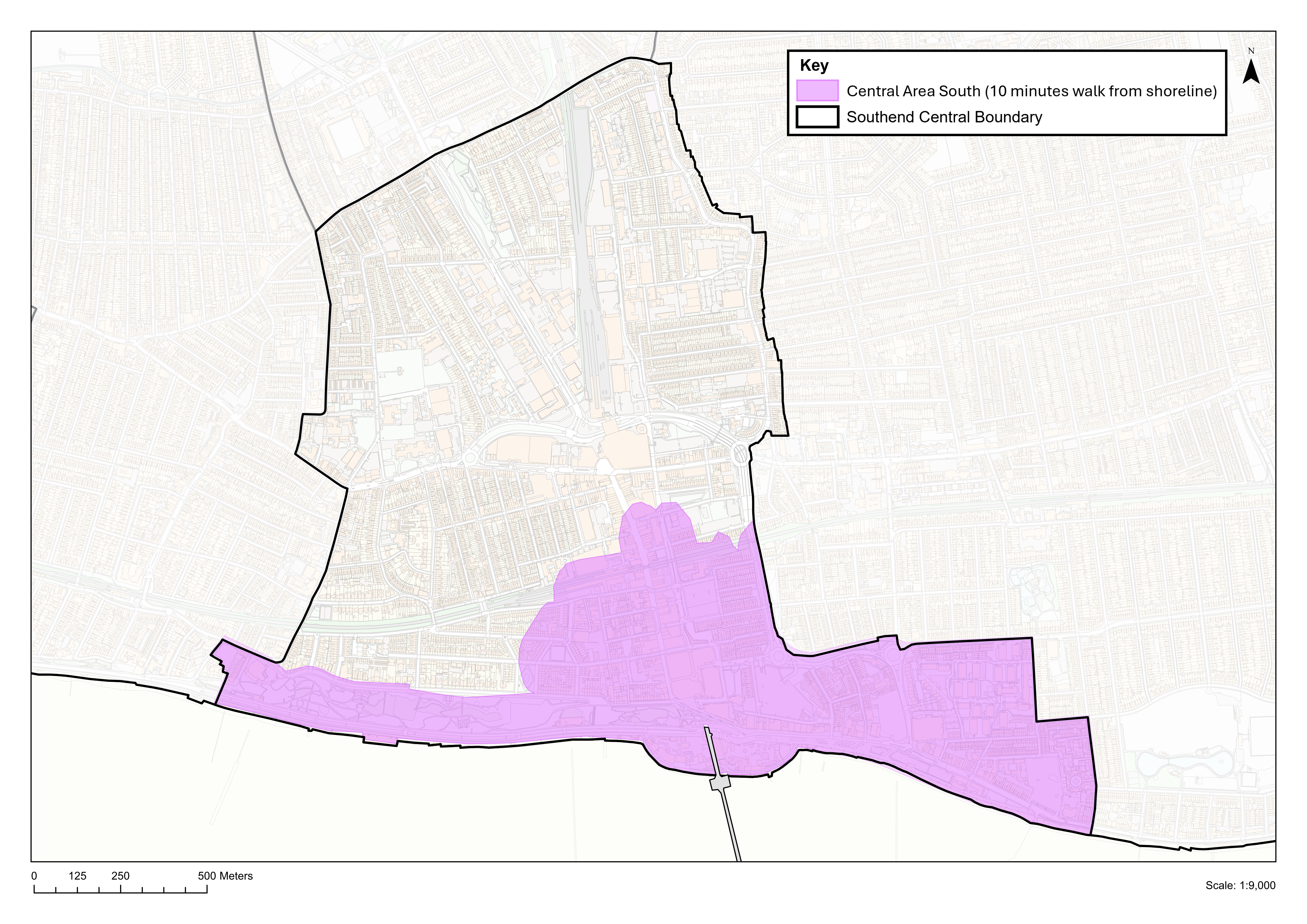
Policy N5d: Traffic Management and Car Parking Provision in Southend Central
- All car parking provision and traffic management measures should be in accordance with Policy DM10.3. Specific additional requirements for car parking provision in Southend Central area are set out below.
- In order to support the vitality and viability of Southend Central the Council will:
- ensure parking capacity* within the Southend Central Area is at a level that supports vitality and viability and does not undermine the areas' ability to accommodate visitor trips, whilst enabling the delivery of relevant site proposals;
- any change in visitor car parking provision as a result of major development proposals to the south of the Central Area (as defined by Map N5d) must not undermine the vitality and viability of the Central Seafront as a significant tourist destination, recognising the peaks and troughs of demand for car parking. Any planning application resulting in a loss of visitor parking in this area would need to be accompanied by a detailed transport assessment that would include an analysis of the impact of the additional parking demand generated by the proposed development on visitor car parks, having regard to:
- adopted parking standards (Policy DM10.3);
- consideration of the extent to which linked/ combined trips and opportunities for further mode shift through the travel plan process will reduce the need for additional visitor parking spaces;
- availability of parking to the south of the Central Area within the area shown in Map N5d; and
- the need for any replacement parking to be provided within the area shown in Map N5d, where it should be secured through a planning condition or obligation as part of the overall development scheme or through another means acceptable to the Council.
- seek to relieve the pressure on the more well-used car parks at peak times and encourage use of less occupied car parks through a combination of dynamic signage, competitive pricing and pre-journey information;
- ensure pedestrian routes to and from public car parks, railway stations and other public transport interchanges are direct, well-lit and signposted, benefiting from a high-quality public realm that links well with main areas of interest;
- ensure new and existing car parks add to the overall aesthetic quality of an area through such measures as landscaping, green walls, public art, pedestrian walkways and pedestrian permeability, as well incorporating innovative layouts to reduce visual impact and effect on key views within and to the Southend Central Area.
* Parking capacity includes provision for cars, motorcycles, taxis, bicycle and Blue Badge holder provision
- The Council will work in partnership with key stakeholders to improve transport infrastructure and access in the Southend Central Area and to secure funding for transport and public realm improvements.
Have your say…
Please explain your answers
QN5d: Do you agree with Policy N5d: Traffic Management and Car Parking Provision in Southend Central? Please explain your answer.
12.6 Southchurch
Southchurch Area Profile
Context and Key Issues
- Southchurch is a residential area east of the City Centre. At its heart the Southchurch Road neighbourhood centre provides a range of shopping, commercial and community uses. Southend East railway station is south of the neighbourhood centre and regular bus services run along the A13 Key Passenger Transport Corridor at Southchurch Road.
- The residential streets spanning out from the centre have traditional Victorian/ Edwardian housing of tightly knit terraced houses and flats/maisonettes on a grid street pattern. Properties in the northern part of the neighbourhood are less regular in form, comprising mainly inter-war housing including some public sector housing around Cluny Square.
- Lower density post war housing is concentrated in the east and south of the neighbourhood, at Bournes Green. Detached housing and bungalows are set within more generous plots focussed on Southchurch Boulevard, providing a green lung running from the neighbourhood centre into the neighbouring Thorpe Bay Neighbourhood.
- Woodgrange Drive Local Centre, Southchurch Hall Gardens and Southchurch Park lie at the southern end of the neighbourhood, surrounded by mainly semi-detached and some terraced properties.
- Southchurch has an average density of 30 homes per hectare (although densities are considerably higher in the terraced streets either side of Southchurch Road) and residents benefit from a broad range of services including health and education, with most able to access day to day services within a 10-minute walk of their home.
- Issues facing the area however include parking stress in the denser residential areas due to the lack of off-street parking facilities and the demand for on street parking from the Southchurch Road neighbourhood centre. On average there are 0.96 cars per household (1.19 per houses and 0.57 per flat)2
- Sports and green infrastructure facilities are provided at Southchurch Park, Bournes Green Park, and to the north, Garon Park and Jones Memorial Recreation Ground, and allotment plots at Hamstel Road, Lifstan Way and Norwich Avenue. To the south there is the seafront area, providing opportunities for leisure, including walking and cycling along the foreshore.
- To the north, within Fossetts Neighbourhood, larger scale facilities are provided at Fossetts Way Retail Park, and employment estates at Stock Road, Temple Farm and Rosshill provide for local employment opportunities.
- See section 3b (and associated questions) regarding an option of a new neighbourhood to the north of Southend.
Vision
12.75 The residential character of Southchurch will be maintained, with Southchurch Road neighbourhood centre providing the focal point for local service and community needs, within easy walking distance for residents. The centre continues to be well served by buses, with good accessibility to Southend East railway station to the south. Opportunities to enhance denser parts of the neighbourhood, particularly the streets to the north of the neighbourhood centre, will be encouraged – including through the provision of landscaping and tree planting to increase local canopy cover and help mitigate the impacts of traffic.
12.76 New homes will comprise a broad range of types to serve housing needs, with potential for intensification along the Southchurch Road A13 corridor, and where opportunities arise for renewal of existing housing areas. Local employment growth will be focussed along Southchurch Road, and adjacent retail park and employment areas to the north within the Fossetts neighbourhood.
12.77 New and enhanced cycle routes will connect Southchurch's residents with the city's main employment and leisure destinations as part of the strategic cycle network. Streets and public spaces, including public parks, will provide an attractive walking environment, with good links to the seafrontDevelopment along the seafront will have regard to Policy DM8.4 and Policy Table DM8.4: Seafront Character Zones. providing opportunities for walking and cycling and leisure activities within the neighbourhood and beyond. Southchurch Hall, and Southchurch Hall Gardens, will continue to provide a visitor attraction, and their heritage will be celebrated and conserved.
Have your say…
Please explain your answers
QN6a: Do you agree with the Vision for Southchurch? Please explain your answer.
See also Q3b: Strategic Policy Option: Question on whether to develop a new neighbourhood on land to the north of Southend
Figure N6: Southchurch Neighbourhood
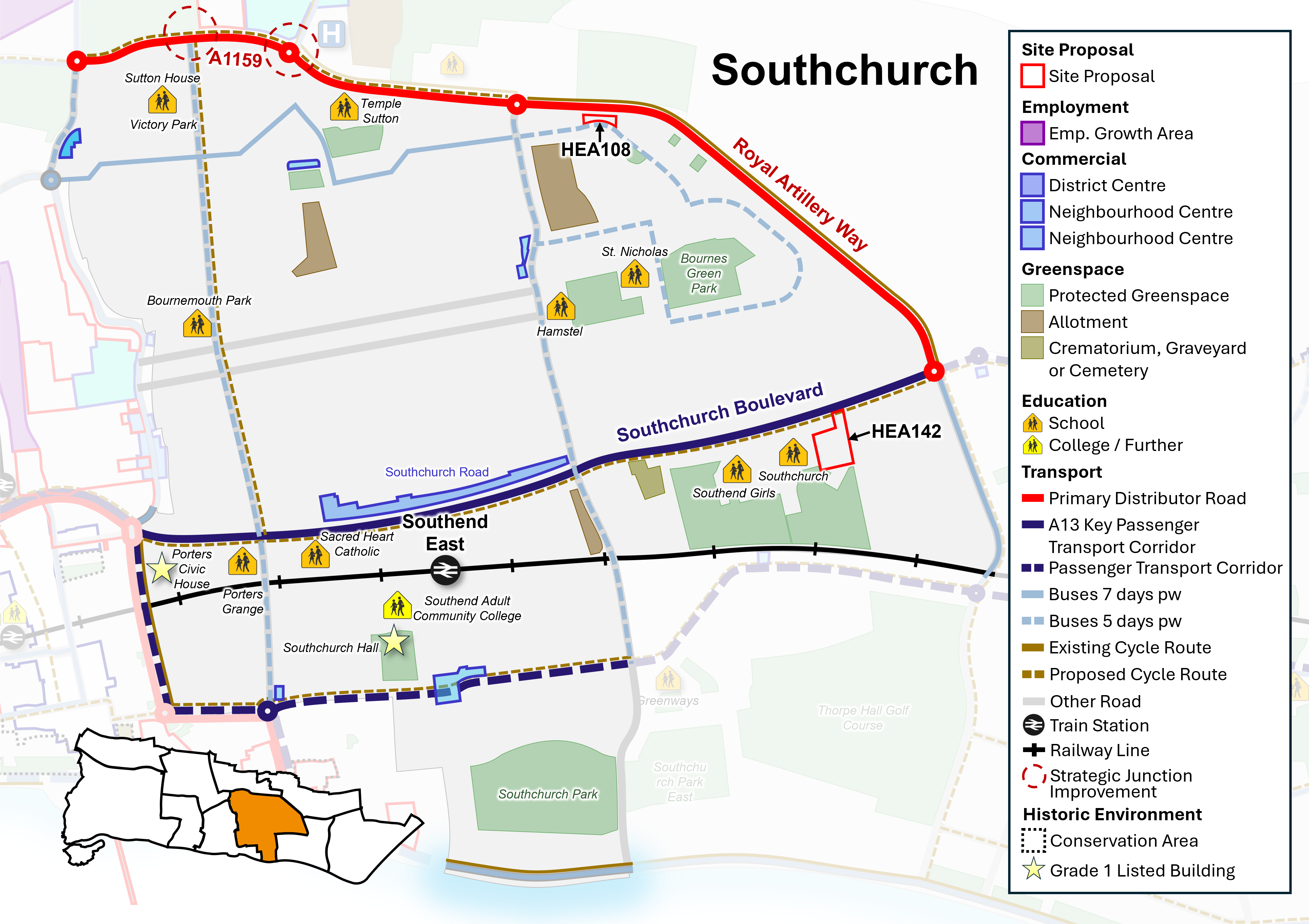
Neighbourhood Policy N6: Southchurch
All development should be in accordance with the Development Plan for the city. Specific requirements for Southchurch are:
Health and well-being
- New development must contribute to healthy lifestyles and address health and wellbeing having regard to Policy SP4.
- New development must be aligned with the provision of necessary infrastructure (including social infrastructure such as health and education) and not place a damaging burden on existing provision (Policy SP3). The Council will seek to protect and manage community facilities and sport and recreation facilities in line with Policies DM4.1 and DM4.2.
Homes
- Seek to safeguard existing dwellings, including family housing, and provide for new homes in line with Policy SP5, DM5.2, DM5.3 and DM5.4 and as per sites identified in Policy N6i (Policy Table N6i).
- Positively consider windfall development particularly where they are of good quality design and optimise the use of land within neighbourhood centres and the A13 Key Passenger Transport Corridor.
- Further housing growth will be focused on opportunities for urban intensification along the main public transport corridor of Southchurch Road, and the renewal of existing housing areas where these can provide better quality homes including for families and specialised forms of housing.
- Ensure that an appropriate balance is struck between meeting the demand for homes in multiple occupation whilst protecting and safeguarding the character and amenities of established residential areas in line with Policy DM5.6.
Economy and Tourism
- Seek to manage employment land and promote economic growth in line with Policy SP6 and DM6.1.
- Manage and support the provision of Class E commercial uses within Southchurch Road Neighbourhood Centre and improve accessibility in line with Policy DM6.4.
- Seek to manage and safeguard visitor accommodation, facilities and assets, including the foreshore, in line with Policy DM6.5
Urban Design, Character and Heritage
- The Council will support good quality design that contributes positivity to the creation of successful places and optimises the use of land having regard to local character and context in line with Policy SP7 and DM7.1. Development along the seafront will have regard to Policy DM8.4 and Policy Table DM8.4: Seafront Character Zones (as defined on the Policies Map).
- Heritage assets within the neighbourhood will continue to be conserved and opportunities to enhance them encouraged, particularly where this would contribute to heritage led regeneration (Policy DM7.6).
- Support public realm improvements focused on Southchurch Road.
Natural Environment and Climate Change
- Protect and enhance the green and blue Infrastructure network within Southchurch, including protected green space, parks and foreshore, in line with Policy SP8, DM8.2, DM8.4.
- Play space will be enhanced within the neighbourhood to improve quality and access.
- Manage and promote tree planting within new development as set out in Policy DM8.6, particularly within Kursaal Ward, and the denser streets north of Southchurch Road, towards the city-wide target of 15% tree canopy cover.
- Development should seek to avoid the risk of flooding, unless otherwise allocated for development, incorporate sustainable urban drainage systems (SuDS) (Policy DM9.4) and address heat stress areas particularly the denser roads north of Southchurch Road with new and enhanced green infrastructure.
- Coastal defences will be upgraded where required to mitigate flood risk and climate change impacts in line with Policy DM8.4 and Policy DM9.4, integrating nature-based solutions wherever possible.
Transport and connectivity
- Promote improvements to the A13 Key Passenger Transport Corridor along Southchurch Road as shown on the Key Diagram.
- Widen travel choice, particularly by walking and cycling, rail, bus (including the enhancement of existing routes and new routes as part of the wider passenger transport network, and demand-responsive transport), car share/ clubs, and taxi in line with Policy SP10.3.
- Proposals to enhance the setting and role of Southend East railway station will be supported in accordance with Policy DM10.4.
- Strengthen and enhance strategic walking and cycling networks in line with Policy DM10.1
Have your say…
Please explain your answers
QN6b: Do you agree with Neighbourhood Policy N6: Southchurch? Please explain your answer.
12.78 The Local Plan designates land for particular purposes, such as to protect valuable green space and key employment areas. The Plan also includes site proposals that identify specific sites for particular uses. This process ensures that land is utilised effectively and strategically and will guide development decisions on future planning applications across the city. See Appendix 2 and accompanying Policies Map for more information.
Policy N6i: Southchurch Site Proposals
- Within Southchurch, allocate sites, as defined on the Policies Map, for development as set out in Policy Table N6i (see also Figure N6):
Policy Table N6i: Sites in Southchurch
|
Ref No |
Site Name |
Proposed Use |
Approx. Homes |
|
Proposed Allocation |
|||
|
HEA142 |
Former Futures College, Southchurch Boulevard |
Residential development complemented by landscaping. |
56 |
|
Broad Location/ Opportunity site |
|||
|
HEA108 |
Vacant land at Archer Avenue |
Residential development complemented by landscaping, improved green space and retention of memorial tree. Other existing trees should be retained or suitably replaced with a preference for on-site re-provision. |
10 |
Have your say…
Please explain your answers
QN6c: Do you agree with Neighbourhood Policy N6i: Site Proposals? Please explain your answer providing the site reference where applicable.
12.7 Fossetts
Context and Key Issues
- This area lies on the northern fringe of Southchurch and eastern edge of Prittlewell, extending east of the Southend to Liverpool Street railway line as far as Garon Park, and northwards up to the boundary with Rochford District Council along Fossetts Way.
- The area contains a cluster of uses that attract a wider catchment, such as the fire station, cemetery and crematorium, Garon Park, allotments, Cecil Jones Academy, Fossetts Way retail park, and the employment areas of Temple Farm, Stock Road and Rosshill.
- Jones Memorial Recreation Ground is protected green space. Land to the east of Jones Memorial Recreation Ground includes Prittlewell Camp Hillfort, a Scheduled Monument protected from development due to its national archaeological importance. The land to the north within Rochford is rural in character.
- Temple Sutton Primary School lies on the south side of Eastern Avenue, which is a busy dual carriageway with a limited number of signalled pedestrian crossings. A wider range of retail and community facilities are available at Southchurch Neighbourhood Centre, located approximately 1 mile to the south, and shopping parades at Cluny Square and Hamstel Road.
- The principle of development at Fossetts Farm, including SUFC Training Ground, Eastern Avenue, has been established through planning permissions for housing and supporting infrastructure, as set out in Policy Table N7 below
- Planning permission on land west of Fossetts Way provides for a new local park and a landscaped buffer around the Scheduled Monument to conserve it and its setting and enhancement works to improve public access.
Vision
12.79 Fossetts will become established over the Local Plan period as a new neighbourhood of Southend, with new homes and associated community and commercial uses. The site allocations in the Local Plan for Fossetts will provide for a cohesive and attractive place through high quality, innovative building design, a legible and clearly defined layout, and soft landscaping providing the neighbourhood with a defining 'green' setting and character. This will form a sustainable community that is also well connected to the existing urban area, with residents benefitting from existing retail, employment, and leisure facilities.
12.80 Urban design will take cues from the vernacular of Southend: building at densities that make efficient and effective use of the land, providing for a mix of housing types and tenures, and supporting infrastructure, including community and commercial uses to support the residential population.
12.81 Permeable walking and cycling routes will be created, forming part of the city's green infrastructure network, with new and enhanced active travel connections to the north via Sutton Road and Rochford Road, via Eastern Avenue to the south and Prittle Brook and Prittlewell Railway Station to the west. Gaps in the strategic cycle network between Priory Park and Fossetts Way will be addressed to provide a safer and more convenient east – west route.
12.82 Good access to bus and rail services within the immediate and wider area will connect new residents with local community facilities and employment opportunities, including London Southend Airport and Prittlewell railway stations. Access to leisure and recreation facilities at Garon Park will be improved, via public transport, walking and cycling. Opportunities for improved access to the adjacent employment areas of Stock Road, Temple Farm and Rosshill, and Fossetts Way Retail Park will be encouraged.
12.83 Garon Park will continue to perform an important role as a leisure, cultural, recreational and community hub for the city, with enhanced sustainable access, including by bus, foot and cycle. Links to the surrounding footpath network will be enhanced to enable access across the wider area, including to Fossetts Farm.
12.84 Southend Cemetery and Crematorium will continue to be protected as a key public service and green infrastructure asset.
Have your say…
Please explain your answers
QN7a: Do you agree with the Vision for Fossetts? Please explain your answer.
Figure N7: Fossetts Neighbourhood
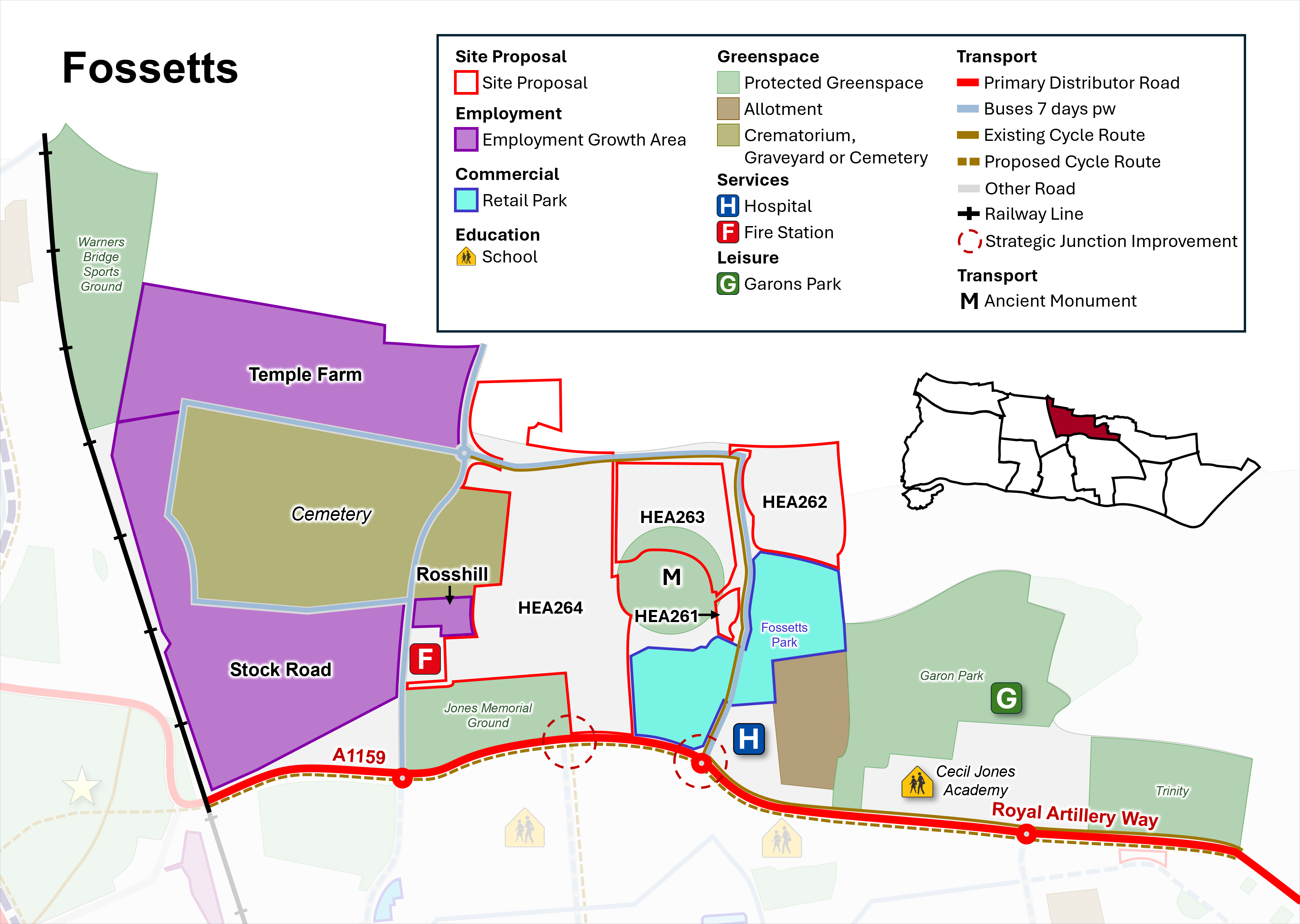
Neighbourhood Policy N7: Fossetts
All development should be in accordance with the Development Plan for the city. Specific requirements for Fossetts are:
Health and well-being
- New development must contribute to healthy lifestyles and address health and wellbeing having regard to Policy SP4.
- New development must be aligned with the provision of necessary infrastructure (including social infrastructure such as health and education) and not place a damaging burden on existing provision (Policy SP3). The Council will seek to protect and manage community facilities and sport and recreation facilities in line with Policies DM4.1 and DM4.2.
- Create well-designed sustainable residential-led development, supported by suitable commercial and community uses to create a walkable neighbourhood with services in easy reach.
Homes
- Seek to provide for a range of homes including family housing, in line with Policy SP5, DM5.2, DM5.3 and DM5.4 and as per sites identified in Policy N7i (Policy Table N7i).
Economy and Tourism
- Seek to manage employment land and promote economic growth in line with Policy SP6 and DM6.1.
- Protect and promote the provision of additional employment floorspace within identified employment areas in line with Policy DM6.3, including within the employment growth areas of Stock Road and Temple Farm and the industrial/ business estate at Rosshill.
- Provide for local needs for day-to-day services and facilities within new development and improve access to Fossetts Way Retail Park, employment areas, and Garon Park, for new and existing residents in line with Policy DM6.4.
Urban Design, Character and Heritage
- Support good quality design that contributes positivity to the creation of successful places and optimises the use of land having regard to local character and context in line with Policy SP7 and DM7.1.
- The Neighbourhood's heritage assets, including the Scheduled Monument at Prittlewell Camp will continue to be conserved and opportunities to enhance them will be encouraged, particularly where this would contribute to heritage led regeneration (Policy DM7.6).
- Support public realm improvements along Eastern Avenue to reduce the severance effect of the road for pedestrians and cyclists and create and enhance public realm and active travel connections between new development and surrounding areas including Fossetts Way Retail Park, employment areas and Garon Park.
Natural Environment and Climate Change
- Protect and enhance the green and blue Infrastructure network within Fossetts, including protected green space, parks and play space, in line with Policy SP8, DM8.2, DM8.3.
- Manage and promote tree planting within new development including new streets, as set out in Policy DM8.6.
- Development should seek to avoid the risk of flooding, unless otherwise allocated for development, and incorporate sustainable urban drainage systems (SuDS) (Policy DM9.4).
Transport and connectivity
- Promote improved passenger transport corridors to the City Centre and to Prittlewell and London Southend Airport railway stations, Garon Park and Shoeburyness, including new and enhanced bus routes.
- Widen travel choice, particularly by walking and cycling, rail, bus (including the enhancement of existing routes and new routes as part of the wider passenger transport network, and demand-responsive transport), car share/ clubs, and taxi in line with Policy SP10.3.
- Pedestrian and cycle connectivity will be enhanced throughout the neighbourhood, including opportunities to improve links between new and established residential areas, commercial centres and protected green spaces and public rights of way, including between Priory Park, Garon Park and the east of the city.
- Gaps in the strategic cycle network between Priory Park and Fossetts Way will be addressed to provide a safer and more convenient east – west route (Figure N7).
Have your say…
Please explain your answers
QN7b. Do you agree with Neighbourhood Policy N7: Fossetts? Please explain your answer.
12.85 The Local Plan designates land for particular purposes, such as to protect valuable green space and key employment areas. The Plan also includes site proposals that identify specific sites for particular uses. This process ensures that land is utilised effectively and strategically and will guide development decisions on future planning applications across the city. See Appendix 2 and accompanying Policies Map for more information.
Policy N7i: Fossetts Site Proposals
- Within Fossetts, allocate sites, as defined on the Policies Map, for development as set out in Policy Table N7i (see also Figure N7):
Policy Table N7i: Sites in Fossetts
|
Ref No |
Site Name |
Proposed Use |
Approx. Homes |
|
Proposed Allocation |
|||
|
HEA261 |
Land West of Fossetts Way (near roundabout and Petrol Station) |
Residential development, with landscaping to ensure integration with surrounding area. Adjacent to Scheduled Monument, to be appropriately addressed as part of any development proposal. |
46 |
|
HEA264 |
Fossetts Farm, including SUFC Training Ground, Eastern Avenue |
A mixed use residential-led development with improved pedestrian, cycle and public transport access, and provision of private and public open space to provide an attractive, green public realm. Development will facilitate improvements/ modernisation of Roots Hall Football Stadium (on site HEA259). |
900 |
|
Site with planning permission to be allocated (Please note a planning permission cannot be rescinded as a result of this consultation) |
|||
|
HEA262 |
Land East of Fossetts Way |
Residential development with landscaping and green space to complement setting. |
221 |
|
HEA263 |
Land West of Fossetts Way |
Residential development, with landscaping and green space to ensure integration with surrounding area. Adjacent to Scheduled Monument, to be appropriately addressed as part of any development proposal. |
131 |
Have your say…
Please explain your answers
QN7c: Do you agree with Neighbourhood Policy N7i: Fossetts Site Proposals? Please explain your answer providing the site reference where applicable.
12.8 Thorpe Bay
Thorpe Bay Area Profile
Context and Key Issues
- Thorpe Bay is a small neighbourhood, characterised by large, low-density homes, green spaces, a strong tree canopy, and an attractive seafront. It is the lowest density established neighbourhood, with the second highest level of car ownership in the city.
- The neighbourhood is bisected by the east-west railway line and is served by Thorpe Bay mainline railway station. To the south of the railway line and east of Thorpe Hall Avenue (notable for its green and tree lined, wide central reservation) the area is characterised by a strong grid pattern, drawn to generous proportions with wide plots of large, predominantly Edwardian and Inter-war, housing as well as a substantial phase of post-war bungalows and houses.
- Wide, tree lined streets are a particular feature of the area, especially in the Burges Estate, which benefits from attractive gardens, tennis courts, bowling green, as well as proximity to the seafront.
- Thorpe Bay Golf course is a private facility, albeit there is public access via a public right of way across the course. Other green space within the neighbourhood includes Thorpe Bay Gardens, Southchurch Park East, and some smaller formal gardens and squares north of the railway line.
- Although there are no children's play areas within Thorpe Bay, Southchurch Park to the west, provides quality public amenity space to the local area, including children's play area and playing pitches, and to the east is a new children's play area at Shoebury Common.
- The golf course and land to the south lies within flood risk zones and Bournes Green roundabout/Thorpe Hall Avenue area is also prone to surface water flooding.
- The Neighbourhood Centre of Thorpe Broadway lies south of Thorpe Bay station, providing a range of local shops and services to the neighbourhood. There are some smaller local centres elsewhere in the neighbourhood.
- North of the railway line is Bournes Green, a planned interwar development built out after World War Two, the form of development largely influenced by the Garden City movement, both in terms of building design and layout of a loose grid pattern, including small cul-de-sacs in each block; towards its centre are Bournes Green Infants and Junior Schools. Beyond this is a large area of housing dating from the 1980s, focussed on Maplin Way North.
- See section 3b (and associated questions) regarding an option of a new neighbourhood to the north of Southend.
Vision
12.86 Thorpe Bay will remain an attractive residential area that benefits from a distinctive tree canopy. Southchurch Park will continue to provide publicly accessible green space and children's play provision, with improved sustainable travel links to surrounding residential areas. The seafront area will continue to provide opportunity for leisure and recreation, and enhancements to the public realm will help support walking and cycling.
12.87 Thorpe Broadway Neighbourhood Centre will remain the retail/ commercial core of the neighbourhood, providing a vibrant range of shops and services to meet the everyday needs of the local community, supported by the smaller Local Centres.
12.88 Sustainable transport options will be enhanced, especially walking and cycle routes and the interchange role of Thorpe Bay Railway Station.
Have your say…
Please explain your answers
QN8a: Do you agree with the Vision for Thorpe Bay? Please explain your answer.
See also Q3b: Strategic Policy Option: Question on whether to develop a new neighbourhood on land to the north of Southend
Figure N8: Thorpe Bay Neighbourhood
Neighbourhood Policy N8: Thorpe Bay
All development should be in accordance with the Development Plan for the city. Specific requirements for Thorpe Bay are:
Health and well-being
- New development must contribute to healthy lifestyles and address health and wellbeing having regard to Policy SP4.
- New development must be aligned with the provision of necessary infrastructure (including social infrastructure such as health and education) and not place a damaging burden on existing provision (Policy SP3). The Council will seek to protect and manage community facilities and sport and recreation facilities in line with Policies DM4.1 and DM4.2.
Homes
- Seek to safeguard existing dwellings, including family housing, and provide for new homes in line with Policy SP5, DM5.2, DM5.3 and DM5.4.
Economy and Tourism
- Seek to manage employment land and promote economic growth in line with Policy SP6 and DM6.1.
- Manage and support the provision of Class E retail and commercial uses in accordance with the retail hierarchy within the Neighbourhood and Local Centres and improve accessibility in line with Policy DM6.4. Opportunities to enhance access to the retail/ commercial centres and the quality of the surrounding public realm will be encouraged.
- Seek to manage and safeguard visitor accommodation, facilities and assets, including the foreshore, in line with Policy DM6.5.
Urban Design, Character and Heritage
- The Council will support good quality design that contributes positivity to the creation of successful places and optimises the use of land having regard to local character and context in line with Policy SP7 and DM7.1.
- Support public realm improvements focused on Thorpe Bay neighbourhood centre and Railway Station, and the seafront.
Natural Environment and Climate Change
- Protect and enhance the green and blue Infrastructure network within Thorpe Bay Neighbourhood, including protected green space, parks, and foreshore in line with Policy SP8, DM8.2, and DM8.4. Development along the seafront will have regard to Policy DM8.4 and Policy Table DM8.4: Seafront Character Zones (as defined on the Policies Map).
- New play spaces and natural 'play on the way' elements will be supported within the neighbourhood where appropriate to improve quality and access.
- Manage and promote tree planting within new development as set out in Policy DM8.6.
- Development should seek to avoid the risk of flooding, unless otherwise allocated for development, and incorporate sustainable urban drainage systems (SuDS) in line with Policy DM9.4.
- Coastal defences will be upgraded where appropriate to mitigate flood risk and climate change impacts and in line with the Thames Estuary 2100 strategy and subsequent reviews in line with Policy DM8.4.
Transport and connectivity
- Widen travel choice, particularly by walking and cycling, rail, bus (including the enhancement of existing routes and new routes as part of the wider passenger transport network, mobility hub, and demand-responsive transport), car share/ clubs, and taxi in line with Policy SP10.3.
- Promote enhancements to the public transport corridor from Shoeburyness to Southend City Centre via Thorpe Bay and bus services from Thorpe Bay to Neighbourhood and Local Centres.
- Improve the public realm around Thorpe Bay Broadway.
- Proposals to enhance the setting and role of Thorpe Bay Railway Station, including as a Mobility Hub, will be supported in accordance with Policy DM10.4.
- Infrastructure for public electric vehicle charging points should be focussed within neighbourhood and local centres and the seafront area.
Have your say…
Please explain your answers
QN8b: Do you agree with Neighbourhood Policy N8: Thorpe Bay? Please explain your answer.
12.9 Shoeburyness
Shoeburyness Area Profile
Context and Key Issues
- The easternmost neighbourhood of Southend, situated to the east of Thorpe Bay. It has several distinct parts and is perhaps one of the most fragmented of the areas in the city, displaying a wide range of spatial and architectural characteristics over a number of distinct zones.
- The Garrison is an important example of Victorian military establishment design with a strong urban form much of which is protected by Conservation Area status set in a generous layout of green spaces and parkland that abuts the coastline. The Garrison buildings have largely been converted to residential uses, and other areas of the wider sites have been built out for residential, developed to integrate with the original form.
- The Garrison, Gunners Park, and the neighbouring East Beach, form part of the attractiveness of the area for tourism and recreation. Where flood risk management is needed along the coast, the use of nature-based solutions is encouraged, including consideration of maintenance and renewal of coastal defences.
- The rest of south Shoebury is more influenced by the neighbouring Thorpe Bay, following a grid pattern with relatively large plots, although tight knit Victorian/ Edwardian terraced housing predominates around the West Road Neighbourhood Centre and Shoebury High Street Local Centre, both of which provide shops and services to the local community.
- North Shoebury is characterised by cul-de-sac development, often lacking in terms of legibility and permeability, and open-plan, modern low-rise development. The area contains the North Shoebury retail park, anchored by a large ASDA store and a small number of complementary commercial units, and large expanse of surface level car parking. There is potential to enhance walking and cycling access here, complemented by opportunities for urban greening.
- The neighbourhood has an important local employment base, focussed around the Employment Growth Areas of Vanguard Way and Towerfield Road, and the industrial/ business estate at Campfield Road.
- The MOD/ QinetiQ still maintains a presence on the 'New Ranges'.
- See section 3b (and associated question) regarding an option of a new neighbourhood to the north of Southend.
Vision
12.89 The historic core around Shoebury Garrison Conservation Area and associated heritage assets continue to be conserved and celebrated for the role they play in the area's character and identity. Gunners Park and East Beach provide for tourism, recreation, and enable access to green space for residents and visitors. Improved pedestrian and cycle connections to Shoeburyness Railway Station, and associated enhancements to the public realm, encourage opportunities for active travel. The tree canopy in the neighbourhood will be enhanced, particularly within West Shoebury ward. Coastal defences and flood risk management continue to be an important consideration in the neighbourhood, including opportunities for nature-based solutions.
12.90 The Neighbourhood and Local Centres provide retail and commercial activity, including opportunities for healthcare, within easy reach for the local community, benefitting from enhanced walking and cycling connections to surrounding residential areas, complemented by urban greening and public realm enhancements
12.91 The Employment Areas of Campfield Road, Towerfield Road and Vanguard Way continue to be protected for employment uses, providing a focus for modern employment floorspace.
Have your say…
Please explain your answers
QN9a. Do you agree with the Vision for Shoeburyness? Please explain your answer.
Figure N9: Shoeburyness Neighbourhood
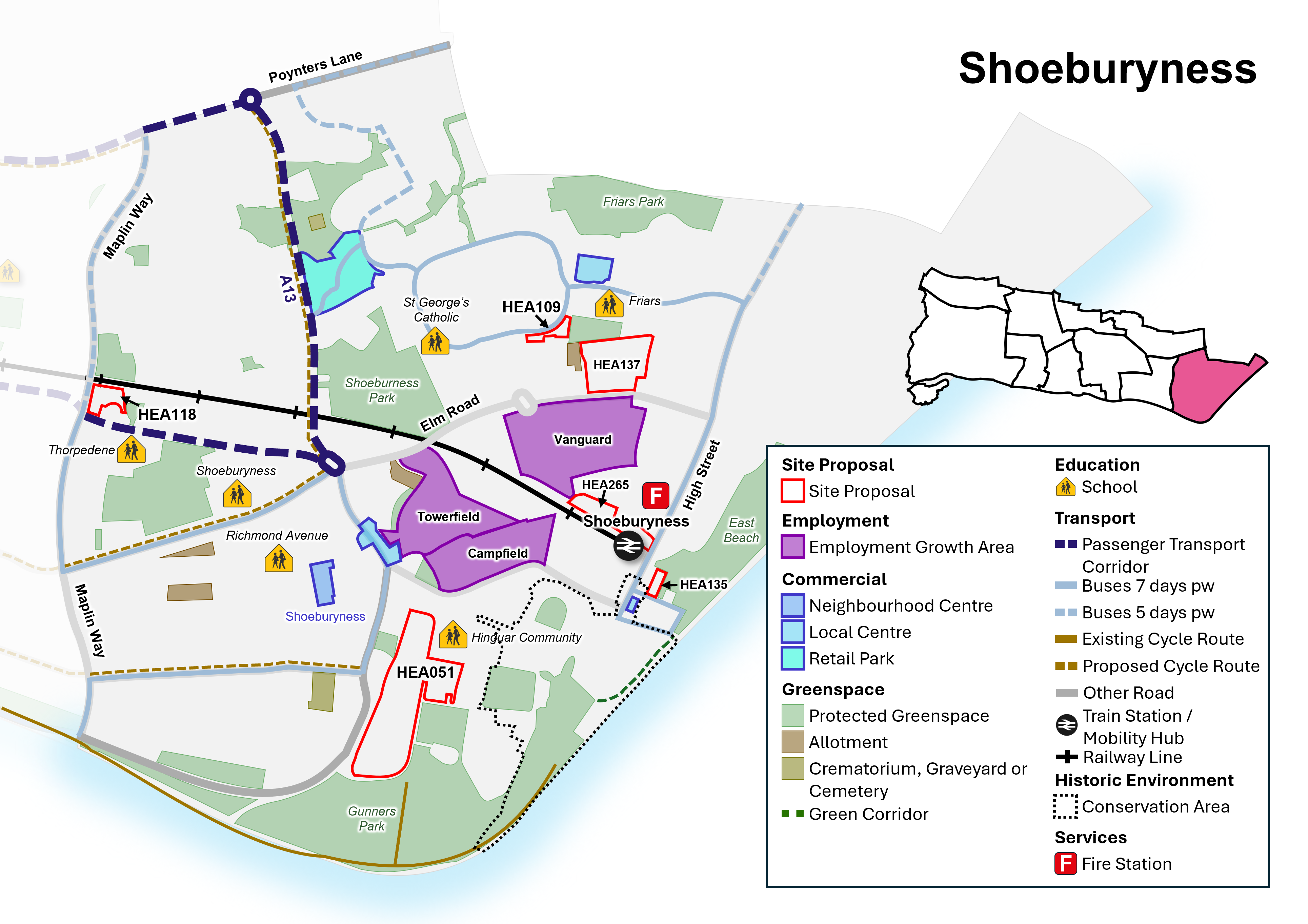
Neighbourhood Policy N9: Shoeburyness
All development should be in accordance with the Development Plan for the city. Specific requirements for Shoeburyness are:
Health and well-being
- New development must contribute to healthy lifestyles and address health and wellbeing having regard to Policy SP4.
- New development must be aligned with the provision of necessary infrastructure (including social infrastructure such as health and education) and not place a damaging burden on existing provision (Policy SP3). The Council will seek to protect and manage community facilities and sport and recreation facilities in line with Policies DM4.1 and DM4.2.
Homes
- Seek to safeguard existing dwellings, including family housing, and provide for new homes in line with Policy SP5, DM5.2, DM5.3 and DM5.4 and as per sites identified in Policy N9i (Policy Table N9i).
- Positively consider windfall development particularly where they are of good quality design and optimise the use of land within the neighbourhood centre.
Economy and Tourism
- Seek to manage employment land and promote economic growth in line with Policy SP6 and DM6.1.
- Protect and promote the provision of additional employment floorspace within identified employment areas at Towerfield Road and Vanguard Way (employment growth areas) and Campfield Road (industrial/ business estate) in line with Policy DM6.3.
- Manage and support the provision of Class E retail and commercial uses in accordance with the retail hierarchy within the neighbourhood and local centres and improve accessibility in line with Policy DM6.4.
- Seek to manage and safeguard visitor accommodation, facilities and assets, including the foreshore, in line with Policy DM6.5.
Urban Design, Character and Heritage
- Support good quality design that contributes positivity to the creation of successful places and optimises the use of land having regard to local character and context in line with Policy SP7 and DM7.1. Development along the seafront will have regard to Policy DM8.4 and Policy Table DM8.4: Seafront Character Zones (as defined on the Policies Map).
- Shoebury Garrison Conservation Area, and other heritage assets within the neighbourhood, will continue to be conserved and opportunities to enhance them encouraged, particularly where this would contribute to heritage led regeneration (Policy DM7.6). Areas of archaeological potential in the neighbourhood should be taken account of within any development proposals (Policy Table DM7.6a).
- Support public realm improvements and urban greening focused within the neighbourhood and local centres, and North Shoebury retail park.
Natural Environment and Climate Change
- Protect and enhance the green and blue Infrastructure network within Shoeburyness Neighbourhood, including protected green space, parks and foreshore, in line with Policy SP8, DM8.2, DM8.4.
- Establish an effective green grid, including green corridors, new and improved public green space as per Map N9.
- Play space enhancements to existing facilities within the neighbourhood to improve quality and access.
- Manage and promote tree planting within new development as set out in Policy DM8.6, particularly within West Shoebury ward.
- Development must seek to avoid the risk of flooding, unless otherwise allocated for development, and incorporate sustainable urban drainage systems (SuDS) (Policy DM9.4).
- Coastal defences will be upgraded to mitigate flood risk and climate change impacts and in line with the Thames Estuary 2100 strategy and subsequent reviews in line with Policy DM8.4.
Transport and connectivity
- Widen travel choice, particularly by walking and cycling, rail, bus (including the enhancement of existing routes and new routes as part of the wider passenger transport network, mobility hub, and demand-responsive transport), car share/ clubs, and taxi in line with Policy SP10.3.
- Promote improvements to the public transport corridor from Shoeburyness Station, via the A13 (Bournes Green Chase, North Shoebury Road, Ness Road, Elm Road), and A1159 (Royal Artillery Way) to London Southend Airport.
- Improve the public realm around Ness Road and the city's cycle network, including the coastal path (Figure N9).
- Proposals to enhance the setting and role of Shoeburyness railway station as a mobility hub will be supported in accordance with Policy DM10.4.
- Infrastructure for public electric vehicle charging points should be focussed within neighbourhood and local centres and the seafront area.
Have your say…
Please explain your answers
QN9b. Do you agree with Neighbourhood Policy N9: Shoeburyness? Please explain your answer.
12.92 The Local Plan designates land for particular purposes, such as to protect valuable green space and key employment areas. The Plan also includes site proposals that identify specific sites for particular uses. This process ensures that land is utilised effectively and strategically and will guide development decisions on future planning applications across the city. See Appendix 2 and accompanying Policies Map for more information.
Policy N9i: Shoeburyness Site Proposals
- Within Shoeburyness, allocate sites, as defined on the Policies Map, for development as set out in Policy Table N9i (see also Figure N9):
Policy Table N9i: Sites in Shoeburyness
|
Ref No |
Site Name |
Proposed Use |
Approx. Homes |
|
Proposed Allocation |
|||
|
HEA118 |
Thorpedene, Delaware Road |
Residential development with potential for community uses as required. |
56 |
|
HEA135 |
Land at George Street, Shoeburyness |
Residential development fronting George Street, with enhanced, publicly accessible open green space to the rear, providing additional recreational space at East Beach. |
8 |
|
Broad Location/ Opportunity Site |
|||
|
HEA137 |
Land at Elm Road, Shoeburyness |
Potential for new school (as required) and residential development, with improved public open space. Development must satisfactorily remediate ground conditions, with all legislation on contamination remediation fully complied with. |
Unknown (subject to provision of school) |
|
HEA265 |
Terminal Close |
Potential for mixed-use residential-led development and potential for small-scale, modern commercial floorspace (such as a small-scale convenience retail store) fronting Shoebury High Street. Release from former employment area designation. |
Unknown |
|
Site with planning permission to be allocated (Please note a planning permission cannot be rescinded as a result of this consultation) |
|||
|
HEA051 |
Land between Barge Pier Road & Ness Road, Shoeburyness |
Mixed use residential development with supporting commercial uses, including health centre, and associated car parking, public open space, pedestrian and cycle connections, SUDS, flood mitigation measures/ design, and landscaping. Principle of development established through planning permission. |
210 |
|
HEA109 |
Land at Eagle Way, Shoeburyness |
Residential development with landscaping to complement setting. |
21 |
Have your say…
Please explain your answers
QN9c: Do you agree with Neighbourhood Policy N9i: Shoeburyness Site Proposals? Please explain your answer providing the site reference where applicable.
13. Delivery and Monitoring
A CITY THAT DELIVERS
13a. This chapter explains how the Local Plan's proposed objectives, policies and proposals will be delivered and monitored.
13.1 This chapter explains how the Local Plan's proposed objectives, policies and proposals will be delivered and monitored. This will be done through the monitoring of the indicators set out in the tables detailed in Appendix 11.
13.2 Each Strategic Policy has a set of key monitoring indicators setting out what the expected outcomes of the policy are. These will be monitored on an annual basis and be published through the Authority's Monitoring Report (AMR). This monitoring will be augmented by appeal decisions made by the Planning Inspectorate in respect of specific development schemes.
13.3 The AMR will be used to report on the performance of the Local Plan as well as recommending any actions required to ensure the delivery of the Local Plan. This could include recommending a specific review of policy and/or to prepare Supplementary Planning Documents (SPD) or Masterplans to give greater clarity and direction to a specific policy. The NPPFNational Planning Policy Framework (NPPF paragraph 34) Ministry of Housing, Communities and Local Government, December 2024 does in any event recommend that Local Plans should be reviewed in their entirety every five years.
13.4 Delivery will be closely linked to the emerging Infrastructure Delivery Plan which accompanies this Local Plan and forms a key part of the supporting evidence. It sets out detailed infrastructure requirements which are essential to the successful sustainable implementation of the Strategic Policies. The infrastructure projects key to achieving delivery are set out in Appendix 4.
Policy DM13.1 Monitoring and Review
- The City Council will undertake regular monitoring to:
- appraise the impact of the Local Plan and measure the effectiveness of its policies and proposals, using the monitoring and implementation framework set out in Appendix 11, particularly with regard to ensuring that development is served by the necessary infrastructure by pursuing an 'infrastructure led' approach;
- appraise the performance of plan preparation with reference to the Local Development Scheme; and
- indicate the need for policy revision, in particular re-appraisal of the phasing and release of further housing or other development, and/or where there may be a need for additional Supplementary Planning Documents and/or Masterplans to effectively guide development schemes.
Have your say…
Please explain your answers
Q13.1: Do you agree with the draft Delivery and Monitoring Framework as set out in Policy DM13.1 and Appendix 11? Please explain your answer with reference to the relevant key indicator number.
Appendix 1 - Glossary
Active travel – modes of travel that involve a level of activity, such as walking, wheeling and cycling.
Affordable housing – housing for sale or rent, for those whose needs are not met by the market (including housing that provides a subsidised route to home ownership and/or is for essential local workers) and falls into one of the following categories: affordable housing for rent, starter homes, discounted market sales housing, or other affordable routes to home ownership:
Affordable housing for rent – set at a level at least 20% below local market rents; and the landlord is a registered provider (except Build to Rent), and there are provisions to remain at an affordable price for future eligible households (or the subsidy can be recycled for alternative affordable housing provision).
- Starter homes – defined in sections 2 and 3 of the Housing and Planning Act 2016 and any secondary legislation under these sections, which currently has the effect of limiting a household's eligibility to purchase, based on a maximum level of income.
- Discounted market sales housing – sold at a discount of at least 20% below local market value, with provisions in place for this to be retained at a discount for future eligible households (determined in relation to local incomes and house prices)/
- Other affordable routes to home ownership – including shared ownership, relevant equity loans, other low-cost homes for sale, and rent to buy (including a period of intermediate rent). Where public grant funding is provided the homes should remain at an affordable price for future eligible households, or receipts recycled for alternative affordable provision.
Agent of change principle - requires the person or organisation responsible for any proposed change to manage its impact
Agricultural land – land in grades 1, 2 and 3a of the Agricultural Land Classification
Airport Safeguarding Zones - are intended to make sure that there isn't a conflict between new development above a certain height and the safe operation of aircraft, including any impacts on radar, instrument landing systems and air traffic control equipment.
Airspace Development – space above existing residential and commercial premises used for the development of new homes by extending upwards.
Air Quality Management Area – area designated by local authorities because they are not likely to achieve national air quality objectives by the relevant deadlines.
Amenity Space – an indoor or outdoor private or shared space that can accommodate a range of activities for residents and the community.
Article 4 Direction – A direction made under Article 4 of the Town and Country Planning (General Permitted Development) (England) Order 2015 which withdraws permitted development rights granted by that Order.
Best and Most Versatile Agricultural Land (BMV) - Land in grades 1, 2 and 3a of the Agricultural Land Classification.
Biodiversity Net Gain (BNG) – a mandatory requirement on new development (unless exemptions apply) to achieve at least 10% gain over and above any existing habitats on site, aiming for biodiversity to be left in a better state than before work took place.
Broad locations / Opportunity sites – areas identified by a Local Planning Authority as the main focus for future development which may be comprised of one or more development sites.
Brownfield Land – see previously developed land.
Build to Rent – purpose-built housing that is typically 100% rented out. It can form part of a wider multi-tenure development of flats and/or houses but should be on the same site and/or contiguous with the main development. Schemes will usually have longer tenancy agreements of three years of more and managed in single ownership and management control.
Blue Flag – an accreditation scheme awarded to well-managed beaches with water quality defined as "excellent."
Blue Infrastructure – includes water features like ponds and rivers, estuaries, and the sea. Together with green spaces it forms part of the green infrastructure network of an area.
Car free or car 'lite' developments – where parking is not provided on site or there is a reduced parking provision, and where there are often restrictions on permits for on-street car parking, to reduce traffic congestion, reduce air pollution and better manage the limited amount of space available for on-street parking and reduce the impact of new homes by encouraging people to walk, cycle and use public transport, within sustainable locations.
Climate change adaptation – Adjustments made to natural or human systems in response to the actual or anticipated impacts of climate change, to mitigate harm or exploit beneficial opportunities.
Climate change mitigation - Action to reduce the impact of human activity on the climate system, primarily through reducing greenhouse gas emissions.
Community Facilities – also referred to as social and community infrastructure, can be defined as physical facilities for different individuals and communities, which are provided by a range of public, private and voluntary organisations.
Community Infrastructure Levy – is a charge that local authorities can set on new development to raise funds to help fund the infrastructure, facilities and services (such as schools or transport improvements) needed to support new homes and businesses.
Complete Neighbourhoods (also referred to as Walkable Neighbourhoods/ Complete Communities) – a planning concept where everyday essentials and services are within a convenient walking or cycle distance to meet basic needs, whilst promoting healthy lifestyles and sustainable living.
Contaminated Land – where substances in the land are causing or could cause significant harm to people, property or protected species, including to controlled waters.
Designated Heritage Asset - are designated under relevant legislation, such as a Scheduled Monument, Listed Building, or Conservation Area.
Design Code - A set of illustrated design requirements that provide specific, detailed parameters for the physical development of a site or area. The graphic and written components of the code should build upon a design vision, such as a masterplan or other design and development framework for a site or area.
Design Review – an independent and impartial evaluation process in which a panel of experts (built environment professionals from a range of disciplines) assess the design of a proposal.
Development Plan – a single document or suite of documents that set out a local authority's policies and proposals for land use in their area.
Digital Infrastructure – the digital technologies that enable the flow of digital products, service and information, including physical assets, software and services.
Embodied carbon – the total amount of greenhouse gas emissions produced during the lifecycle of a building or infrastructure, including mining and processing materials, transportation, construction, maintenance and decommissioning.
Energy Efficiency – using less energy for the same output or producing more with the same output, and minimising energy waste.
Essex Design Guide – non-statutory planning guidance on a range of issues for use by Local Planning Authorities, developers and other bodies
Examination in public – a process that assesses whether a local plan is legally and procedurally sound, managed by the Planning Inspectorate (a body independent of the Local Planning Authority). After the examination the Plan Inspector/s produce a report that recommends whether the Local Plan can be adopted.
EDNA – Economic Development Needs Assessment
Flood Risk Area – inappropriate development in areas at risk of flooding should be avoided by directing development away from areas of highest risk, but where development is necessary, making it safe without increasing flood risk elsewhere
Green Flag – An international accreditation given to parks and open spaces that are well-managed and publicly accessible.
Green Infrastructure - A network of multi-functional green and blue spaces and other natural features, urban and rural, which is capable of delivering a wide range of environmental, economic, health and wellbeing benefits for nature, climate, local and wider communities and prosperity.
Greenfield development – development on land which has not previously been developed with buildings or other structures.
Green Belt – an area of land around a town or city where building is not usually allowed. The boundaries of green belt are established by Local Planning Authorities through their development plans.
Grey Belt - For the purposes of plan-making and decision-making, 'grey belt' is defined as land in the Green Belt comprising previously developed land and/or any other land that, in either case, does not strongly contribute to any of purposes (a), (b), or (d) in NPPF paragraph 143. 'Grey belt' excludes land where the application of the policies relating to the areas or assets in NPPF footnote 7 (other than Green Belt) would provide a strong reason for refusing or restricting development.
Gross Internal Area (GIA) - The Gross Internal Area of a dwelling is defined as the total floor space measured between the internal faces of perimeter walls that enclose the dwelling. This includes partitions, structural elements, cupboards, ducts, flights of stairs and voids above stairs. The Gross Internal Area should be measured and denoted in square metres (sqm).
Heat Stress – results from a greater expanse of buildings and paved ground in urban areas which absorb heat causing temperatures to rise. Human activities such as warming buildings and driving vehicles can also add heat to surroundings. The presence of green and blue spaces can help to mitigate this.
HELAA – Housing and Employment Land Availability Assessment.
Heritage Asset - A building, monument, site, place, area or landscape identified as having a degree of significance meriting consideration in planning decisions, because of its heritage interest. It includes designated heritage assets and non-designated heritage assets including those identified by the Local Planning Authority (such as local listing).
Health Impact Assessment (HIA) – HIA is a way to provide decision-makers and stakeholders with information about the consequences on health of policies and projects.
Houses in Multiple Occupation (HMO) – an HMO is a property where three or more unrelated occupiers pay rent for exclusive use of part of the property and share a toilet, bathroom or kitchen with someone else in the property. One of the occupiers could be the owner. Planning permission is required for HMOs with more than 6 occupants (also referred to as Large HMOs). HMOs with five or more people require a licence under the Housing Act 2004.
Housing Delivery Test - Measures net homes delivered in a local authority area against the homes required, using national statistics and local authority data. The Secretary of State will publish the Housing Delivery Test results for each local authority in England annually.
Housing stock – the number of houses and other places to live in a particular place e.g. Southend.
Infrastructure Delivery Plan (IDP) – a document setting out the infrastructure needs of a given area, and how to meet those needs, including what is needed, where, when, how much it will cost, and how it will be funded. They are used to support local plans and ensure development happens in a coordinated way.
Infrastructure Led Approach – Development must be accompanied by supporting infrastructure. New or improved infrastructure must be planned from the outset and delivered first or at pace to meet the needs of new development. For larger development proposals that may be built out over a number of years this should take account of phasing to ensure that utilities and supporting services and facilities are in place to ensure new communities are sustainable and can thrive.
JAAP – Joint Area Action Plan – a local plan document produced jointly by two or more Local Planning Authorities.
Key Diagram – a visual representation of a spatial strategy that illustrates the broad location for development and other key components of a Local Plan such as opportunity areas, town centres, and key transport hubs and corridors.
Listed Building – buildings that are of special architectural or historic interest can be listed, which gives them legal protection. The record of each listed building is hosted on the National Heritage List for England (known as the NHLE, or the List).
Local Housing Need - The number of homes identified as being needed through the application of the standard method set out in national planning practice guidance.
Local Plan - A plan for the future development of a local area, drawn up by the local planning authority in consultation with the community, under the Town and Country Planning (Local Planning) (England) Regulations 2012. Can consist of either strategic or non-strategic policies, or a combination of the two.
Local Planning Authority (LPA) – the public authority whose duty through legislation is to carry out specific planning functions for a particular area, including responsibility for producing Local Plans, undertaking planning enforcement, and determining planning applications.
Major development - For housing, development where 10 or more homes will be provided, or the site has an area of 0.5 hectares or more. For non-residential development it means additional floorspace of 1,000sqm or more, or a site of 1 hectare or more, or as otherwise provided in the Town and Country Planning (Development Management Procedure) (England) Order 2015.
Meanwhile uses – temporary uses that occupy vacant or underutilised premises, sites or spaces, often on previously developed land.
Microclimate – the climate of a very small and restricted area, especially where this differs from the surrounding area, for example where temperatures are higher within an urban area or wind tunnel effects are experienced between tall buildings.
Microgeneration – the generation of electricity or heat on a small scale, typically for domestic use for low, zero or renewable energy (up to 50 kilowatts for electricity and 45 kilowatts for heat).
Minerals – natural concentrations of materials including rock and sand that are extracted and processed for use in construction and everyday goods. Minerals are a non-renewable resource and must be worked (i.e. extracted) where they are found. Minerals safeguarding ensures that non-minerals development does not needlessly prevent the future extraction of mineral resources, of local and national importance.
Mobility hubs – places in a community that can maximise shared transport and interchange with public transport and active travel in spaces designed to improve the public realm for all.
Modal shift – the process of moving from car journeys to buses, trains or other forms of public transport, cycling and walking, or using a combination of modes, and creating a more sustainable transport system that benefits us all.
Multi-modal – offering the choice of more than one form of transport.
Nationally described space standards – national requirements for the gross internal floor area of new dwellings at a defined level of occupancy as well as floor areas and dimension for key parts of the home, including bedrooms, storage, and floor to ceiling height.
Nature Recovery Network - An expanding, increasingly connected, network of wildlife rich habitats supporting species recovery, alongside wider benefits such as carbon capture, water quality improvements, natural flood risk management and recreation. It includes the existing network of protected sites and other wildlife rich habitats and other areas capable of expanding the network, where there is coordinated action for species and habitats.
Neighbourhoods - The Local Plan has identified nine neighbourhoods in Southend (see Neighbourhood Policies), each with its own characteristics and priorities.
Net Zero development – the balance between the amount of greenhouse gas emissions produced and the amount that are removed from the atmosphere. It can be achieved both through emission reduction and emission removal (i.e. carbon capture and storage).
National Planning Policy Framework (NPPF) – the national policy framework for land use planning.
Non-designated heritage asset - include those that are identified by the Local Planning Authority, which include for Southend: Locally Listed Buildings, Frontages of Townscape Merit, and non-designated sites of archaeological importance.
Open Space - All open space of public value, including not just land, but also areas of water (such as rivers, canals, lakes and reservoirs) which offer important opportunities for sport and recreation and can act as a visual amenity.
Operational carbon – the emissions associated with energy used to operate a building or in the operation of infrastructure, including heating, hot water, cooling, ventilation, lighting and lifts.
Park and Ride/Rail – a place where you can park your car and take a bus or other form of public transport into the centre.
Permitted Development Rights – allow development to take place (for example for householders on their property) without the need to make a planning application.
Planning Obligation - a legal agreement entered into under Section 106 of the Town and Country Planning Act 1990 to mitigate the impacts of a development proposal.
Planning Practice Guidance (PPG) – guidance for England setting out how the NPPF policies should be applied in practice, and to provide further information.
Previously developed land - land which is or was occupied by a permanent structure, including the curtilage of the developed land (although it should not be assumed that the whole of the curtilage should be developed) and any associated fixed surface infrastructure. This excludes: land that is or was last occupied by agricultural or forestry buildings; land that has been developed for minerals extraction or waste disposal by landfill, where provision for restoration has been made through development management procedures; land in built-up areas such as residential gardens, parks, recreation grounds and allotments; and land that was previously developed but where the remains of the permanent structure or fixed surface structure have blended into the landscape.
Public Art - created for the general public, whether situated on public or private property, it is visible from the public realm.
Public Realm – streets and spaces that are accessed by the public.
Public Safety Zones - are triangular areas located at the end of runways as defined in the DfT Policy Paper "Control of development in airport public safety zones" (updated October 2021). PSZ's restrict new development such as housing and employment within the designated area.
Rapid transit – high-capacity public transport that is generally built in urban areas.
RAMS – Essex Coast Recreation Avoidance and disturbance Mitigation Strategy.
Real Time Information – data that is updated continuously, for example bus service information or car parking capacity.
Renewable energy - Includes energy for heating and cooling as well as generating electricity. Renewable energy covers those energy flows that occur naturally and repeatedly in the environment – from the wind, the fall of water, the movement of the oceans, from the sun and also from biomass and deep geothermal heat. Low carbon technologies are those that can help reduce emissions (compared to conventional use of fossil fuels).
Seafront Character Areas – sub-areas of the Southend Foreshore and adjacent built environment, divided on the basis of their distinct characteristics in relation to land use, heritage and environment.
Section 106 agreement – a legally binding agreement between a Local Planning Authority and a developer or landowner, to mitigate the impacts of the development on the local community and infrastructure.
SCAAP – Southend Central Area Action Plan (adopted in 2018) contains planning policies and allocations for the city centre and central seafront area.
(national) Standard Method – a formula that incorporates a baseline of local housing stock which is adjusted upwards to reflect local affordability pressures to identify the minimum number of homes expected to be planned for.
Supplementary Planning Document (SPD) - Documents which add further detail to the policies in the development plan. They can be used to provide further guidance for development on specific sites, or on particular issues, such as design. Supplementary planning documents are capable of being a material consideration in planning decisions but are not part of the development plan.
Special Areas of Conservation - Areas defined by regulation 3 of the Conservation of Habitats and Species Regulations 2017 which have been given special protection as important conservation sites.
Special Protection Areas - Areas classified under regulation 15 of the Conservation of Habitats and Species Regulations 2017 which have been identified as being of international importance for the breeding, feeding, wintering or the migration of rare and vulnerable species of birds.
Square metre (sqm) – a unit of measurement for area, equivalent to the space of a square with sides that are one metre long.
Sui Generis – "of its own kind" or in a class by itself. Usually referring to land use types that do not fall within any particular category and need to be evaluated based on the merits of the individual circumstances.
Sustainability – meeting the needs of the present without compromising the ability of future generations to meet their own needs.
SuDS – Sustainable urban Drainage Scheme designed to reduce surface water run-off within and beyond a development.
Tall Buildings - defined, for the purposes of the Local Plan, as buildings that are substantially taller and/ or bulkier and out of scale with the prevailing built form of the surrounding area, and/ or have a significant impact on the skyline of Southend. This will differ across the city.
Transport Assessment – a comprehensive and systematic process that sets out transport issues relating to a proposed development. It identifies measures required to improve accessibility and safety for all modes of travel, particularly for alternatives to the car such as walking, cycling and public transport, and measures that will be needed deal with the anticipated transport impacts of the development.
Transport Statement - a simplified version of a transport assessment where it is agreed the transport issues arising from development proposals are limited and a full transport assessment is not required.
Travel Plan - a long-term management strategy for an organisation or site that seeks to deliver sustainable transport objectives and is regularly reviewed.
Tree Preservation Order – an order made by a Local Planning Authority to protect specific trees, groups of trees, or woodland in the interests of amenity.
Urban Design – the design of towns and cities, buildings, and the spaces between them, in order to make successfully functioning and quality places.
Urban Greening – the process of adding green spaces and elements into urban environments and infrastructure, such as streets, roofs, and walls, for climate change mitigation, flood risk management and health and well-being.
Urban Greening Factor – a method of quantifying the amount of green infrastructure provided within a new development compared with the existing situation, with the aim of providing a measurable increase.
Use Class – various categories of use which relate to the use of land and buildings, as set out in the Town and Country Planning (Use Classes) Order 1987 (as amended).
Viability – for planning, viability assessments should not compromise sustainable development but should be used to ensure that policies are realistic and that the total cumulative cost of all relevant policies will not undermine the deliverability of the plan.
Windfall sites - sites not specifically identified in the development plan.
Appendix 2 – Sources of housing supply and list site proposals
Table A2i: Sources of housing supply
|
Source |
Description |
|
Planning Permission |
Includes sites that already benefit from planning permission and can be implemented. Planning permissions cannot be rescinded. It is proposed that all sites that have permission for 5 homes or more will be allocated within the Local Plan. |
|
Allocations |
Allocations include sites that are deliverable and there is a clear intention to develop within the plan period. These comprise sites that are available for development drawing upon information from the Call for Sites exercise or from relevant planning application documentation. A site is considered available where the landowner/ promoter has expressed an intention to develop or sell the site for development. Site size threshold for allocation within the Local Plan is 5+ homes or more. |
|
Broad Locations/ Opportunity Sites |
National Planning Policy outlines that authorities can identify broad locations for growth where possible, and these are likely to come forward in later years of the plan periodNPPF December 2024, Paragraph 72(b). Delivery of such sites is less certain and therefore only a proportion of the potential capacity has been assumed by 2040 (approximately 50% of the supply from these sites is assumed to be delivered by 2040). Nevertheless, designating suitable Broad Locations/ Opportunity Sites and setting a policy pre-text will improve the likelihood of delivery and assist with managing future development proposals. Future reviews of the Local Plan can determine whether the designation of Broad Locations/ Opportunity Sites has been effective in bringing sites forward. |
|
Windfall development |
Windfall sites are those that are not specifically identified from the outset in the Local Plan. They normally comprise previously developed land that has unexpectedly become available. These could include, for example, large sites resulting from an unforeseen commercial closure or small sites such as a residential conversion or a new flat over a shop. Windfall can include permitted development that does not require planning permission, and therefore, the Council has limited influence on managing such development. As Southend is almost exclusively urban with areas of old building stock, it is inevitable that there will be further development within the existing urban area and a continual supply of land and buildings reaching the end of their useful life in their current use, which may be suitable for residential use or redevelopment. Such developments assist with regeneration, urban renewal and inward investment but should conform with development management and design led policies to ensure there is not a detrimental impact on the local area. Opportunities to increase the net number of units on windfall sites will be considered favourably unless adverse impacts would significantly and demonstrably outweigh the benefits, when assessed against the policies in the Development Plan when taken as a whole. The Council will support the improvement and/ or renewal of existing housing estates and sheltered housing to provide high quality, adaptable, energy efficient homes. Opportunities to increase the net number of units will be considered favourably unless adverse impacts would significantly and demonstrably outweigh the benefits, when assessed against the policies in the Development Plan when taken as a whole. If redevelopment is proposed the tenure and affordability of any potential new accommodation should not preclude existing residents or suitable accommodation is available elsewhere locally. The Council will support the redevelopment of identified outmoded/ underused employment land to provide additional new homes that relate better to nearby existing residential properties and may include an element of new commercial floorspace. A Development Brief and/ or design code should be agreed with the Council to successfully guide and manage re-development, providing high quality, energy efficient buildings. |
Figure A2.ii – Site Proposals

Table A2ii: List of Site Proposals
|
Ref No |
Site Name |
Proposed Use |
Approx. Homes |
|
EASTWOOD NEIGHBOURHOOD |
|||
|
Proposed Allocation |
|||
|
CA004 |
Nestuda Way |
Mixed-use commercial development opportunity with potential for improved access, burial ground, energy generation and flexible commercial floorspace (Class E - business and/ or convenience retail), addressing height constraints given proximity to airport. |
N/A |
|
Site with planning permission to be allocated (Please note a planning permission cannot be rescinded as a result of this consultation) |
|||
|
HEA130 |
Land at Lundy Close, Southend |
Residential development, complemented by landscaping. |
9 |
|
LEIGH NEIGHBOURHOOD |
|||
|
Proposed Allocation |
|||
|
HEA272 |
Former Police Station, Elm Road, Leigh-on-Sea |
Mixed use scheme with commercial/ community ground floor use providing active frontage, retaining locally listed façade with residential to rear and upper floors. |
5 |
|
HEA018 |
658 London Road, Leigh-on-Sea |
Mixed use residential development with commercial use at ground floor providing active frontage. Principle of development established through previous planning permission. |
25 |
|
HEA069 |
Former Car Showroom, 831-837 London Road, Leigh-on-Sea (north of Chalkwell Park) |
Mixed use residential development with commercial ground floor providing active frontage. |
52 |
|
HEA120 |
843 London Road, Leigh-on-Sea |
Mixed use residential development with commercial use at ground floor providing an active frontage. Principle of development established through previous planning permission. |
9 |
|
HEA178 |
986-1006 London Road, Leigh-on-Sea |
Mixed use residential development with potential for commercial ground floor providing active frontage. |
17 |
|
HEA110 |
Vacant Land to the rear of 11-33 Juniper Road |
Residential development, complemented by landscaping, green space and improved access. |
8 |
|
Site with planning permission to be allocated (Please note a planning permission cannot be rescinded as a result of this consultation) |
|||
|
HEA008 |
Sarah Moore, 57-59 Elm Road, Leigh-on-Sea |
Continued use as public house with residential development to upper floors. |
6 |
|
HEA063 |
939-953 London Road, Leigh-on-Sea |
Mixed use residential development with commercial ground floor providing an active frontage. |
30 |
|
HEA067 |
Former Old Vienna Restaurant, Eastwood Road, Leigh-on-Sea |
Residential development, complemented by landscaping. |
13 |
|
HEA176 |
1285 London Road, Leigh-on-Sea |
Mixed use residential development with commercial ground floor providing active frontage. |
17 |
|
HEA181 |
1131-1111 London Road, Leigh-on-Sea |
Residential development with commercial ground floor providing active frontage. |
6 |
|
PRITTLEWELL NEIGHBOURHOOD |
|||
|
Allocation |
|||
|
HEA117 |
Land between Prince Avenue and A127 (former cattery) |
Residential development, complemented by landscaping and provision of green buffer between the rear of the site and Prince Avenue (A127). |
29 |
|
HEA131 |
St Stephen's Church, Manners Way |
Church and supporting community use, play area, and potential for complementary residential uses. |
7 |
|
HEA217 |
Land at Prittlewell Chase, adjacent to Brook Meadows House |
Residential development (potential for extra care/ assisted living/ key worker accommodation) complemented by landscaping. |
31 |
|
HEA259 |
Roots Hall Stadium |
Renovation of Roots Hall Football Stadium to provide a modern community stadium with complementary food and drink uses, with potential for some enabling residential development. |
Unknown |
|
Broad Location/ Opportunity Site |
|||
|
HEA139, HEA140A, HEA140B, HEA141 |
Land to the South of Eastwoodbury Lane |
Potential for new school (HEA141 as required) and residential development, together with improved access, enhanced public space, and allotment provision. Part of site (HEA140A) has planning permission. |
Unknown (subject to school provision) |
|
HEA266 |
Prince Close |
Potential redevelopment including residential, with landscaping, particularly to western boundary adjacent to commercial uses. |
Unknown |
|
WESTCLIFF NEIGHBOURHOOD |
|||
|
Broad Location/Opportunity Site |
|||
|
HEA091 |
Land at Westcliff Station (adj Valkyrie Road) |
Potential for residential development with landscaping. |
12 |
|
HEA115 |
Part of Hamlet Court Road Car Park |
Potential for residential development subject to operational requirements for public parking. |
10 |
|
Site with planning permission to be allocated (Please note a planning permission cannot be rescinded as a result of this consultation) |
|||
|
HEA083 |
30-32 The Leas |
Residential development, providing opportunity for well-designed development that contributes to and conserves and enhances the character and setting of the Crowstone Conservation Area. |
9 |
|
SOUTHEND CENTRAL NEIGHBOURHOOD |
|||
|
SOUTHEND CENTRAL NEIGHBOURHOOD – CITY CENTRE |
|||
|
Proposed Allocation |
|||
|
HEA006 |
Central House, 8 Clifftown Road, Southend |
Mixed use residential development with commercial use (at ground floor) providing active frontage to High Street and Clifftown Road. Located in city centre primary shopping area. Adjacent to locally listed building (Southend Central Station). |
170 |
|
HEA037 |
96 Southchurch Road, Southend |
Mixed use, residential-led development with commercial use at ground floor providing an active frontage. Principle of development established through previous planning permission. |
8 |
|
HEA045 |
48 Alexandra Street, Southend |
Mixed use residential development with commercial ground floor providing an active frontage, with the frontage of townscape merit designation of the former building and adjacent buildings informing the detailed design. Principle of development established through previous planning permission. |
9 |
|
HEA082 |
4 Southchurch Road, Southend |
Mixed use residential development with commercial ground floor use providing active frontage in this city centre location. Principle of development established through previous planning permission. |
24 |
|
HEA278 |
90 High Street, Southend |
Mixed use residential development with commercial/ community use to ground floor providing active frontage in this city centre location. Principle of development established through previous planning permission. |
9 |
|
HEA280 |
1b Queens Road, Southend |
Residential development. Principle of development established through previous planning permission. |
9 |
|
CA006 |
Victoria Avenue West |
Mixed use, residential led development with some supporting commercial uses to ground floor providing an active frontage, and green space/ green infrastructure provision/ enhancements. |
850 |
|
Broad Location/ Opportunity Site |
|||
|
HEA085 |
Tylers Avenue |
Retain and enhance public parking with potential for ancillary development, public transport interchange, with associated public realm enhancements and landscaping to provide urban greening within the central area. Existing Allocation in the Southend Central Area Action Plan. |
N/A |
|
HEA267 |
Grainger Road |
Potential for cultural led regeneration, which could comprise mixed-use development with residential and live-work units, and potential for modern commercial floorspace to part of the site, with amenity space and landscaping. |
Unknown |
|
HEA269 |
Central Station (and land adjacent), Clifftown Road |
Continued used of railway station (locally listed), with public realm and forecourt enhancements. Potential for adjacent mixed use residential development with commercial uses at ground floor, taking into consideration the locally listed station and its setting. |
Unknown |
|
CA005 |
Victoria Avenue East |
Broad location with potential for regeneration, including residential, public sector, and quality public realm enhancements, with improved/ enhanced green space provision, subject to continuation of existing uses. The museum and civic fountain, both Grade II listed will be conserved and enhanced. Existing Allocation in the Southend Central Area Action Plan. |
Unknown |
|
CA009 |
The Royals Shopping Centre |
Potential for well designed, comprehensive mixed-use redevelopment with active ground floor commercial uses and frontages, including potential for repurposed retail offer, leisure, food and drink, residential to upper floors and enhanced public parking provision. Maximising opportunities for estuary views from the south elevation of the building through its detailed design. |
Unknown |
|
CA010 |
The Victoria Shopping Centre |
Potential for enhanced/ modernised commercial offer, including retail, food and drink, leisure, public sector, office, and healthcare uses. Potential for enhanced public realm and parking, and pedestrian connectivity to Chichester Road and Southend Victoria station. |
N/A |
|
CA011 |
London Road (Southend Central) |
Potential within area for retention of ground floor commercial uses with potential for increased building heights and residential above. Potential to provide enhanced pedestrian connections from Queensway, and to address Queensway frontage through the orientation and detailed design of buildings, complemented by enhanced public realm and urban greening. |
Unknown |
|
EA019 |
Whitegate Road |
Potential opportunity to provide employment floorspace. |
N/A |
|
Site with planning permission to be allocated (Please note a planning permission cannot be rescinded as a result of this consultation) |
|||
|
HEA009 |
9 Elmer Approach, Southend |
Mixed use residential development with commercial use at ground floor providing active frontage. |
136 |
|
HEA072 |
Former Empire Theatre, Alexandra Street, Southend |
Mixed use residential development with commercial ground floor use providing active frontages (to both Alexandra Street and Clarence Street). |
22 |
|
HEA096 |
Better Queensway |
Opportunity for comprehensive regeneration to include well-designed, landmark buildings within the City Centre. Mixed use residential development with commercial and community uses to ground floors providing active frontages, with open space and public realm enhancements, improved connectivity for pedestrians and cyclists, parking provision, and highways works. Existing Allocation in the Southend Central Area Action Plan. |
1,760 |
|
HEA282 |
7 Tylers Avenue, Southend |
Mixed use residential development with commercial ground floor providing active frontage in this City Centre location. |
50 |
|
SOUTHEND CENTRAL NEIGHBOURHOOD – CENTRAL SEAFRONT |
|||
|
Proposed Allocation |
|||
|
EA041 |
Southend Pier |
Conserve and enhance the historic Grade II listed Pier and enhance leisure and cultural use, including food and drink and small scale retail provision. Existing Allocation in the Southend Central Area Action Plan. |
N/A |
|
CA012 |
The Kursaal |
Potential for leisure/ cultural/ tourism uses to provide visitor attractions, conserving and enhancing the historic Grade II listed Kursaal building. There may be potential for enabling residential uses to rear. |
N/A |
|
CA013 |
Land between Clifftown Parade and Western Esplanade |
Opportunity to enhance public open green space, with potential for cultural/ leisure use. Existing Allocation in the Southend Central Area Action Plan. |
N/A |
|
Broad Location/ Opportunity Site |
|||
|
HEA042 |
Former Gas Works, Eastern Esplanade |
Retention of public parking with potential for mixed use development particularly to the north of the site, comprising residential and commercial (which could include hotel). Principle of development established through previous planning permission. |
To be determined |
|
Site with planning permission to be allocated (Please note a planning permission cannot be rescinded as a result of this consultation) |
|||
|
HEA054 |
Marine Plaza, Southend |
Mixed use residential and commercial development, with potential to create a landmark building in central seafront location - principle of development established through previous planning permission. Part of the site is within Flood Zone 3. Consideration to be given to the setting of adjacent Kursaal Conservation Area and Grade II listed Kursaal. |
282 |
|
SOUTHEND CENTRAL NEIGHBOURHOOD – SURROUNDING RESIDENTIAL AREAS |
|||
|
Proposed Allocation |
|||
|
CA007 |
Sutton Road |
Mixed use, residential-led development with supporting commercial uses to ground floor providing an active frontage, with green space/ green infrastructure provision and enhancements. |
150 |
|
HEA107 |
53-57 Sutton Road, Southend |
Mixed use residential and commercial development, retaining the locally listed façade of the Cooperative building. |
50 |
|
Site with planning permission to be allocated (Please note a planning permission cannot be rescinded as a result of this consultation) |
|||
|
HEA048 |
215-215a North Road, Southend |
Residential development. |
9 |
|
HEA078 |
165 Sutton Road, Southend |
Residential development, complemented by landscaping. |
22 |
|
HEA277 |
141-159 Sutton Road, Southend |
Mixed use residential development with commercial ground floor use providing active frontage to local shopping parade. |
34 |
|
SOUTHCHURCH NEIGHBOURHOOD |
|||
|
Proposed Allocation |
|||
|
HEA142 |
Former Futures College, Southchurch Boulevard |
Residential development complemented by landscaping. |
56 |
|
Broad Location/ Opportunity site |
|||
|
HEA108 |
Vacant land at Archer Avenue |
Residential development complemented by landscaping, improved green space and retention of memorial tree. Other existing trees should be retained or suitably replaced with a preference for on-site re-provision. |
10 |
|
FOSSETTS NEIGHBOURHOOD |
|||
|
Proposed Allocation |
|||
|
HEA261 |
Land West of Fossetts Way (near roundabout and Petrol Station) |
Residential development, with landscaping to ensure integration with surrounding area. Adjacent to Scheduled Monument, to be appropriately addressed as part of any development proposal. |
46 |
|
HEA264 |
Fossetts Farm, including SUFC Training Ground, Eastern Avenue |
A mixed use residential-led development with improved pedestrian, cycle and public transport access, and provision of private and public open space to provide an attractive, green public realm. Development will facilitate improvements/ modernisation of Roots Hall Football Stadium (on site HEA259). |
900 |
|
Site with planning permission to be allocated (Please note a planning permission cannot be rescinded as a result of this consultation) |
|||
|
HEA262 |
Land East of Fossetts Way |
Residential development with landscaping and green space to complement setting. |
221 |
|
HEA263 |
Land West of Fossetts Way |
Residential development, with landscaping and green space to ensure integration with surrounding area. Adjacent to Scheduled Monument, to be appropriately addressed as part of any development proposal. |
131 |
|
SHOEBURYNESS NEIGHBOURHOOD |
|||
|
Proposed Allocation |
|||
|
HEA118 |
Thorpedene, Delaware Road |
Residential development with potential for community uses as required. |
56 |
|
HEA135 |
Land at George Street, Shoeburyness |
Residential development fronting George Street, with enhanced, publicly accessible open green space to the rear, providing additional recreational space at East Beach. |
8 |
|
Broad Location/ Opportunity Site |
|||
|
HEA137 |
Land at Elm Road, Shoeburyness |
Potential for new school (as required) and residential development, with improved public open space. Development must satisfactorily remediate ground conditions, with all legislation on contamination remediation fully complied with. |
Unknown (subject to provision of school) |
|
HEA265 |
Terminal Close |
Potential for mixed-use residential-led development and potential for small-scale, modern commercial floorspace (such as a small-scale convenience retail store) fronting Shoebury High Street. Release from former employment area designation. |
Unknown |
|
Site with planning permission to be allocated (Please note a planning permission cannot be rescinded as a result of this consultation) |
|||
|
HEA051 |
Land between Barge Pier Road & Ness Road, Shoeburyness |
Mixed use residential development with supporting commercial uses, including health centre, and associated car parking, public open space, pedestrian and cycle connections, SUDS, flood mitigation measures/ design, and landscaping. Principle of development established through planning permission. |
210 |
|
HEA109 |
Land at Eagle Way, Shoeburyness |
Residential development with landscaping to complement setting. |
21 |
Appendix 3 - List of adopted planning policies to be replaced by the Southend New Local Plan
The current adopted planning policies to be replaced by the Southend New Local Plan upon adoption are set out below.
- Southend Core Strategy DPD (2007) - all policies to be replaced by Southend New Local Plan upon adoption. Southend
- Development Management DPD (2015) - all policies to be replaced by Southend New Local Plan upon adoption. Southend Central
- Area Action Plan (SCAAP) (2018) - all policies to be replaced by Southend New Local Plan upon adoption.
Appendix 4 - Summary of Infrastructure Requirements
A4.1 Background
A4.1.1 This appendix summarises the contents of the Infrastructure Delivery Plan (IDP) which accompanies this local plan. The full IDP can be viewed here: https://localplan.southend.gov.uk/evidence-documents.
A4.1.2 The IDP will be updated following consultation on the 'Preferred Approach' Local Plan. It will be a 'living document' with the information provided being a 'snapshot' in time and as such will be subject to review over the lifetime of the Local Plan.
A4.1.3 The IDP forms a key part of the Local Plan evidence base. It assesses the existing provision of infrastructure throughout the city area and sets out details of what additional essential infrastructure is required to ensure the successful sustainable implementation of the strategic policies contained in the new Local Plan.
A4.1.4 The IDP does not consider all infrastructure types but instead focuses on key items of infrastructure which will be required to support the delivery of growth proposed in the emerging new Local Plan. 'Infrastructure' is defined as physical, social and green items required to enable sustainable development.
A4.1.5 The IDP has assessed the infrastructure requirements of the draft local plan having regard to three cumulative growth scenarios, with Scenario 3 reflecting the growth outlined in the Preferred Approach Local Plan (Strategic Policy SP2: Spatial Strategy). This includes any windfallWindfall development is the term used for the development of land which has not been specifically identified as available in the local plan process. Windfall sites typically comprise previously-developed sites or infill sites which become unexpectedly available. development expected during the plan period, any sites with existing planning permission in the area, and sites which are being considered as potential development allocations within the emerging draft Local Plan. The Scenario would result in approximately 10,000 new homes being developed within Southend between 2023-2040.
A4.1.6 The draft Strategic Policy Option of a potential new neighbourhood on Green Belt land north of Southend (see Section 3b of the draft local plan) and its potential additional infrastructure needs is also assessed by the IDP. It is considered in two parts, namely:
- Growth Scenario 4: Green Belt land north of Southend within the administrative are of Southend. This scenario could deliver approximately 4,000 – 5,000 new homes between 2023 – 2040; and
- Growth Scenario 5: Green Belt land north of Southend within the administrative area of Southend and including adjoining land within the Rochford District. This scenario could deliver up to approximately 10,000 new homes between 2023 – 2040.
A4.1.7 The infrastructure needs and projects identified in the IDP which are key to achieving delivery of the local plan, based on the different growth scenarios, are summarised below.
A4.2 Infrastructure Needs Summary
Land Within the Existing Urban Envelope of Southend and at Fossetts Farm
Draft Strategic Policies SP2 and SP5 (Scenarios 1 to 3 of the IDP)
Highways and Transport
A4.2.2 The strategic highways network experiences high levels of congestion, including the A13 and A127, and parts of the network are considered to be operating near or at its design capacity. The Local Plan growth proposals will result in an increased use of the highways network, public transport services, and active travel routes throughout the city. Therefore, any significant plans for growth across the South Essex area will require additional strategic transport infrastructure interventions. The Council has commissioned the production of a transport assessment which is currently being progressed and will include modelling to assess the impacts and potential mitigation measures required to the highways network to support the delivery of growth.
A4.2.3 Considering the potential needs for transport related infrastructure improvements and based on the levels of growth proposed within the Local Plan, transport related infrastructure improvements will be required in Southend and likely focussed to where the highest levels of growth are occurring. The limited capacity of the A127 may present a significant challenge for highways access at Southend Airport unless mitigated.
Community Infrastructure
A4.2.4 Community infrastructure need is likely to be adequately met through improvements to existing facilities funded by developer contributions or through the direct delivery of new spaces in strategic developments. There is a need for additional burial space and the Council have assessed several options to meet demand with the preferred option being the purchase of a 30-acre site to the north of the current settlement edge, however this has not yet been progressed. There may also be need for new allotment space to support the potential growth outlined in the draft local plan.
Education
A4.2.5 The growth being proposed through the draft Local Plan will result in an increase in the demand for education facilities for Early years/childcare (EY&C), primary, secondary and post-16 education places together with special needs. Further education facilities would be sought through developer contributions.
A4.2.6 Based on the estimated pupil product and available capacity, it is likely that the majority of EY&C demand arising from growth would require extended or new EY&C facilities. There is currently a surplus of primary school places in most parts of the city area, and this will assist in accommodating the short-term increase in demand from proposed growth. Beyond this, additional primary education infrastructure will be required to support growth. The level of growth associated with Scenario 3 would create a demand for primary education places which would go beyond the capacity of existing schools. This would therefore require the provision of additional primary education infrastructure. This is not of a scale sufficient to warrant the construction of a new primary school, therefore these additional needs would be provided through extensions to existing primary schools as required.
A4.2.7 While there is currently a small surplus of secondary school places across the city, this is expected to be entirely used by existing needs in the area, leading to a deficit in secondary capacity by 2027. Any growth proposed within the area will therefore require the provision of additional secondary school infrastructure. Based on the pupil product being generated, it is estimated that Scenario 3 would require the provision of a new 10 form entry secondary school.
A4.2.8 Post-16 provision required to meet growth needs could be provided as part of the required new secondary school. The potential need for additional SEND places would not be sufficient to warrant a new standalone SEND facility. Therefore, where needs for extended and new mainstream schools have been identified, it is expected that specialist resource provisions (SRP) will be included within these proposals.
Emergency Services
A4.2.9 All the emergency services would be impacted by the proposed growth scenarios. The East of England Ambulance Service have advised that this would result in a requirement for 3 additional ambulance vehicles for Scenario 3, additional space for parking at ambulance stations; additional paramedics, support staff and call handlers; and expansion to ambulance stations and hubs. An additional response post may also be required to accommodate growth.
A4.2.10 Essex Police have indicated that proposed housing growth would give rise to significant additional resource needs and implications requiring appropriate funding by developers in order to mitigate and manage the community safety, cohesion and policing requirements, including the crime impacts arising. The baseline fire and rescue service resources within Southend are operating at capacity and would be significantly impacted by growth levels being considered in the emerging Local Plan. Essex County Fire & Rescue Service therefore requires additional fire and rescue infrastructure/ facilities to be funded and/or provided by developers either through section 106 agreements or CIL. The need for stand alone new site facilities has not been identified.
Health
A4.2.11 There is a significant deficit of existing capacity for primary care services such as GP surgeries in all areas of the city. The proposed growth scenarios would result in population increases that would generate increased demand for and use of primary healthcare services across the city, and an increased demand for and use of acute care services at Southend Hospital. The NHS have advised that growth of around 10,000 people would require the provision of a new small 700sqm primary care facility. Given the geographic spread of growth being proposed across the Southend neighbourhoods, it is unlikely that one new facility would provide appropriate access to meet the spread of additional needs that could be created by the proposed levels of growth. The provision of around 2 new primary care facilities may therefore be necessary, in addition to the extension of existing facilities where possible.
Green Infrastructure and Open Space
A4.2.12 The infrastructure related impacts of growth in Southend in relation to Green Infrastructure and Open Space are significant and require a strategic approach to achieve appropriate standards of access to natural greenspace for the new population of Southend. It is expected that joined up green and blue infrastructure projects would be provided as part of on-site mitigation in line with growth, alongside strategic delivery of projects via a range of funding measures to assist in delivering the long term vision of the South Essex Green and Blue Infrastructure Delivery Strategy, and the Local Nature Recovery Strategy, due to be published in 2025. Suitable Alternative Natural Greenspaces (SANGs) would also be required to be delivered on-site via specific developer contributions.
Sport, Indoor and Built Facilities
A4.2.13 Current needs for playing pitches and indoor and built facilities can be met by improvements to the quality of existing infrastructure. However, as Southend-on-Sea experiences growth, the total built infrastructure requirements are likely to increase as well as the requirements for outdoor sports infrastructure. Developer contributions and grant funding will be sought to improve provision.
Flood Management
A4.2.14 Parts of the city area along the course of the Prittle Brook, Eastwood Brook, and Willingale Brook are currently subject to increased risk of fluvial flooding. Any additional growth within these areas will need to take into account this risk, and the increased risk as a result of climate change, and this will need to be demonstrated within Flood Risk Assessments submitted as part of any development applications. Parts of the city along the seafront as well as areas of Shoeburyness are currently at increased risk of tidal flooding. New development and growth in this area will need to account for both maintenance of existing flood defences, and provision of new flood defences to offset projected sea level rises as a result of climate change.
A4.2.15 The drainage system capacity is in need of enhancement as surface water flooding poses a flood risk to the city area. Lack of capacity in the drainage system has been found to be a cause and an exacerbating factor for previous surface water flooding events that have occurred within the city area. As surface water flooding poses a risk to large parts of the city, most growth sites should be assumed to require additional surface water flood risk mitigation measures within the development design. Current and future projected surface water flood risk will need to be considered within a Flood Risk Assessment submitted as part of any development proposal. It is expected that flood management infrastructure will be incorporated into all emerging development proposals for Local Plan site allocations.
Utilities – Electricity
A4.2.16 UK Power Networks (UKPN) is the distribution network operator for Southend and the South East. UKPN divide their jurisdiction into three operating areas. Eastern Power Network (EPN) is responsible for electricity provision in Southend. The latest Long Term Development Statement for Eastern Power Networks (LTDS) and Network Development Plan (NPD) for Eastern Power Networks, both published in 2024, indicate no current capacity issues across the EPN area. However, forecasts indicate negative demand headroom in a number of local substations from 2035 onwards (i.e., actual demand would exceed network supply).UKPN is pursuing a programme to unlock additional generation capacity across the area through identifying and removing network constraints. Growth in Southend would require reinforcement of the electricity network to accommodate the associated increase in electricity consumption. Such an increase could be accommodated by reinforcing some of the existing substations.
Utilities – Gas
A4.2.17 Cadent Gas is the distribution network operator responsible for maintenance of the natural gas distribution network in Southend.Cadent note in their Long Term Development Plan (2022) that growth in housing and the rise in gas-fuelled power generation sites over the medium term are constantly changing network capacity requirements. In the North London region (containing Southend), Cadent are carrying out general network reinforcements for this reason.
Utilities – Communications
A4.2.18 The South Essex Councils, including Southend, are pursuing the deployment of a full fibre network – providing faster internet connectivity across the region. Additionally, as part of their commercial roll out programme, Openreach are delivering full fibre to premises in Southend, covering approximately 85,000 homes and businesses, with the sea front identified as a particular priority area. Southend worked with CityFibre and Vodafone UK to embed gigabit broadband services across the city in 2023, bringing the fastest possible internet speeds. Thus far, five internet service providers are aiding businesses and residents with take-up. In addition, Virgin Media O2 are planning to invest in Southend through the implementation of a next generation fibre network, with the project scheduled to commence in 2025.
Utilities – Potable Water
A4.2.19 Essex and Suffolk Water (ESW) supply potable (drinking) water to the city area.The water sources that supply Southend-on-Sea with potable water are the rivers Chelmer, Blackwater, Stour and Roman River (none of which fall within Southend's City boundary), and Hanningfield Reservoir in Chelmsford. ESW published its most recent Water Resource Management Plan in October 2024. It covers the period 2025 to 2050. During the period 2025-2040, ESW have planned for 11,240 dwellings being built in the city area, based on projections from consultants, and 6,440 dwellings in the whole of Rochford District Area. ESW highlight that for development over this level, they would need to assess the proposed phasing of development to accommodate any necessary new or improved infrastructure.
A4.2.20 New or improved infrastructure may include expansion of an existing service reservoir or a new, additional reservoir with a pumping station, as well as replacement of strategic mains (as these would be undersized) and major network reconfiguration at distribution level for security of supply throughout the city area.
A4.2.21 Funding to deliver the new / improved infrastructure would be via infrastructure charges which are collected by water and sewerage companies when new or developed properties connect to their networks.
Wastewater treatment
A4.2.22 Wastewater management and treatment is provided to Southend-on-Sea by Anglian Water Services (AWS). The Southend Water Recycling Centre (WRC) catchment serves the whole of Southend-on-Sea unitary area and part of Castle Point Borough Council Area. Growth in the Southend WRC catchment would likely impact on network capacity and improvements to wastewater infrastructure would be funded through charges to developer and Anglian Water investments.
Waste Management
A4.2.23 The growth scenarios can be accommodated within the forecasts used in the new Waste Contract which takes account of growth for the life of the contract (2025 – 2032). Additional resource will be required through the life of the contract, including collection vehicles and additional litter bins. The identified growth will result in additional waste collection costs, to be charged earlier within the Waste Contract. There are no additional costs or infrastructure projects identified which would be required to support the Growth Scenarios at this stage.
A4.2.24 The main infrastructure requirements are summarised in Table A4.1
Table A4.1: Main Infrastructure Requirements
Scenario 3: Development within the existing urban envelope (draft Strategic Policies SP2 and SP5) |
|
|
Infrastructure type |
Infrastructure Item |
|
Transport, Highways |
Additional strategic transport infrastructure interventions |
|
Active travel and public transport projects |
|
|
Transport related infrastructure improvements will be required in the neighbourhood areas where the highest levels of growth are occurring. |
|
|
Community Infrastructure |
Improvements to existing community facilities. |
|
Need for additional allotment space. |
|
|
Need for additional library provision. |
|
|
Need for additional burial space. |
|
|
Education |
Improvements to early years and childcare |
|
Additional primary education infrastructure - to be provided through extensions to existing primary schools as required. |
|
|
Provision of a new 10 form entry secondary school. |
|
|
Emergency Services |
An additional ambulance response post may be required. |
|
Additional resources and facilities for Police and Fire services. |
|
|
Health |
Provision of 2 new primary care facilities in addition to the extension of existing facilities. |
|
Increase acute healthcare provision at Southend hospital |
|
|
Green Infrastructure |
Delivering the long term vision of the South Essex Green and Blue Infrastructure Delivery Strategy and the Local Nature Recovery Strategy. |
|
Sports, indoor and built facilities |
Improvements to the quality of existing infrastructure. |
|
Flood management / Utilities, wastewater management |
Flood management infrastructure incorporated into all emerging development proposals. |
A4.3 Additional Infrastructure Needs
Option of a New Neighbourhood on Green Belt Land North of Southend
Draft Strategic Policy Option 3b (Scenarios 4 and 5 of the IDP)
A4.3.1 If it is deemed appropriate to pursue the option of developing green belt land north of Southend to meet future housing needs, this will generate further significant additional infrastructure requirements. The IDP considers these requirements in a detailed annex to the IPD which can be viewed here: https://localplan.southend.gov.uk/evidence-documents. These are summarised below.
Initial Infrastructure Assessment
A4.3.2 The development of land north of Southend is still only a possible option in the local plan and subject to further consultation. As such there are no definitive plans. An assessment of infrastructure requirements at this stage can therefore only provide an indication of need. The actual requirements and costs will be calculated in detail based on the specific needs of the area to support any potential planning application should the scheme be pursued as part of the local plan preparation process.
A4.3.3 The identified infrastructure requirements set out in the IDP Annex represent the best information available at this time. This information may therefore be amended and refined as further details become available and the Local Plan growth strategy is finalised.
A4.3.4 The potential additional infrastructure requirements required if the development of land north of Southend is pursued, are summarised in Table A4.2 below.
Table A4.2: Additional Infrastructure Requirements – Green Belt Land North of Southend
|
Infrastructure type |
Scenario 4: New neighbourhood on Green Belt Land North of Southend within administrative area of Southend (Circa. 4,000 – 5,000 new homes in Southend) |
Scenario 5b: Expanded new neighbourhood on additional Green Belt Land within Rochford (comprises administrative area of Southend and Rochford District) (Circa. 10,000 new homes in Southend and Rochford) |
|
Infrastructure Item |
Infrastructure Item |
|
|
Transport, Highways, public transport, and active travel |
Junction improvements on A1159, A13, and B1017 |
Junction improvements on A1159, A13, and B1017 and potential new junctions on Sutton Road/ Southend Road |
|
Increased capacity on the surrounding highway network, particularly on the A1159, A13, and B1017 and the wider strategic network (A127). |
Increased highways capacity on the surrounding highway network, particularly on the A1159, A13, and B1017, Sutton Road, Southend Road and wider strategic network (A127). |
|
|
New road network across the growth area |
New road network across the growth area |
|
|
Extensions to existing bus services |
Extensions to existing bus services |
|
|
Improvements to rail station facilities, and improved public transport connections to rail stations |
Improvements to rail station facilities, and improved public transport connections to rail stations |
|
|
Create new pedestrian and cycle connections to surrounding areas. |
Create new pedestrian and cycle connections to surrounding areas. |
|
|
Highways, public transport, and active travel improvements being tested within the draft Transport Assessment |
Highways, public transport, and active travel improvements being tested within the draft Transport Assessment |
|
|
Community Infrastructure |
New and extended community infrastructure, including a community hall or hub, library facilities, allotments and cemetery provision. |
New and extended community infrastructure, including a community hall or hub, library facilities, allotments and cemetery provision. |
|
Education |
New Early Years and Childcare facilities (2x56 place co-located with a primary school; 1x56 place facility; and 2x 30 place facility) |
New Early Years and Childcare facilities (5 x 56 place co-located with a primary school; 3 x 56 place facility; and 5 x 30 place facility) |
|
2 x 2 form entry primary schools. |
4 x 2 form entry primary schools. |
|
|
A new 6 form entry secondary school. (could be delivered alongside 1 of the primary schools as a through school) |
A new 8 form entry secondary school. (could be delivered alongside 1 of the primary schools as a through school) |
|
|
SEND provision to be included as part of mainstream schools. |
SEND provision to be included as part of mainstream schools. |
|
|
Healthcare |
A new 700sqm primary healthcare facility. |
3 new primary healthcare facilities. |
|
Improvements / expansion of Southend Hospital |
Improvements and expansion of Southend Hospital and/or development of a new hospital. |
|
|
Emergency services |
Additional resources and facilities, and a new ambulance. |
Additional resources and facilities, and three new ambulances. |
|
Additional resources and facilities for Police and Fire services. |
Additional resources and facilities for Police and Fire services. |
|
|
Green Infrastructure |
New parks, amenity space and children's play of around 15 hectares, and around 31 hectares of natural and semi-natural greenspace. |
New parks, amenity space and children's play of around 33 hectares, and around 68 hectares of natural and semi-natural greenspace. |
|
Sports, indoor and built facilities |
Expansion of existing nearby indoor and outdoor facilities and the provision of new indoor and outdoor facilities. |
Expansion of existing nearby indoor and outdoor facilities and the provision of new indoor and outdoor facilities. |
|
Utilities, potable water |
Expansion of existing service reservoir or new reservoir with pumping station. |
Expansion of existing service reservoir or new reservoir with pumping station. |
|
Utilities, wastewater management |
Wastewater management system additions and upgrades. |
Wastewater management system additions and upgrades. |
|
Waste management |
Additional and extended services. |
Direct costs unlikely, outside of Council's administrative area. |
Appendix 5 - Health Impact Assessment Checklist
To be completed by the applicant/ applicants' agent.
Part 1 – Applicant details and proposal summary.
|
Planning application reference: |
|
|
Proposal address: |
|
|
Proposal postcode |
|
|
Person responsible for completing this Health Impact Assessment: |
|
|
Contact email: |
|
|
Date submitted to Planning and Building Control Department: |
|
|
Please provide a summary of the application proposal (No more than 500 words) |
|
|
Provide summary of any engagement with health partners including outcomes e.g. scheme changes and improvements incorporated (No more than 500 words) |
Part 2 – Health Impact Assessment Checklist of development issues
This checklist has been designed to support a Health Impact Assessment. It aims to bring together the policy requirements in the Local Plan and national standards (for example housing optional technical standards) which influence health and wellbeing, to aid decision making. It provides questions to consider when assessing a proposal and examples to support implementation. The questions are not exhaustive, and not all questions will be of relevance to all proposals.
When completing the checklist, reference should be made to the latest available local health data https://www.smartsouthend.org/
The potential for adverse or positive impacts on the local population, including relevant sub-population groups, should be considered against each question, as well as any other health-related consideration of relevance to the development.
Impact – positive/negative/neutral
Length of effect – temporary/permanent; short/medium/long
Impacted Groups (this list is not exhaustive):
- BAME communities
- people of any gender
- LGBT individuals
- people of any age including:
- children,
- young people,
- working age adults
- older people
- disabled people or people suffering from poor health
- religious or faith groups; pregnant women
- any other key population groups locally such as people suffering from socio-economic deprivation.
Health Impact Assessment Screening Matrix
Complete the matrix to identify potential impacts on health and wellbeing, based on the below questions.
|
Ref |
HIA Screening Criteria |
Yes/No/N/A |
Impact |
Length of Effect |
Impacted Groups |
Comments |
|
Healthy Homes |
||||||
|
H1.1 |
Is a mix of types, tenures and sizes of dwellings provided? |
|||||
|
H1.2 |
Are homes both internally and externally designed to be adapted for arising health and wellbeing needs i.e. room adaptation, mobility equipment? |
|||||
|
H1.3 |
Does the development have any specialist housing proposed? Do homes meet Building Regulations Part M? |
|||||
|
H1.4 |
Have homes been built to a recognised building standard or quality mark? |
|||||
|
H1.5 |
Do the dwellings meet or exceed the nationally described space standard and have access to natural light, especially to habitable rooms? Have buildings been designed to provide appropriate internal space for rooms, along with circulation and external space? |
|||||
|
H1.6 |
Do the dwellings include any private outdoor amenity space, or communal outdoor space where applicable? |
|||||
|
H1.7 |
Is there an appropriate (policy compliant) allocation / mix of affordable housing and if so, at what percentage? |
|||||
|
H1.8 |
During which phase/s will those affordable homes be released? |
|||||
|
H1.9 |
Do homes have dedicated / appropriate space to work from home? |
|||||
|
H1.10 |
Are the dwellings energy efficient? Do they meet current national / local standards? |
|||||
|
Active and Sustainable Environments |
||||||
|
A1.1 |
Is a diverse mix of land uses such as homes, schools, shops, workspace, community facilities and open space provided on site or within a comfortable (800m) walking distance? |
|||||
|
A1.2 |
Does the proposal prioritise pedestrian, cycle and public transport access ahead of the private car? |
|||||
|
A1.3 |
Does the proposal promote a legible, integrated, direct, safe and attractive network of walking and cycling routes suitable for all users and that encourages people to use these readily? |
|||||
|
A1.4 |
Does the proposal consider the safety of pedestrians and cyclists, including vulnerable road users? |
|||||
|
A1.5 |
Are walkable communities created, providing opportunities to facilitate initiatives such as "walking buses" to school, and supporting a network of connected walking and cycling routes? |
|||||
|
A1.6 |
Are the walking and cycling routes provided safe, well lit, overlooked, welcoming, well-maintained, durable and clearly signposted? |
|||||
|
A1.7 |
Are streets and spaces of a high quality, with durable materials, street furniture and signage? |
|||||
|
A1.8 |
Does the public realm allow all people to move easily between buildings and places? |
|||||
|
A1.9 |
Does the development integrate with existing public transport infrastructure and services or provide new passenger transport services to the site? |
|||||
|
A1.10 |
Have sustainable travel plans been developed, approved and funded for the construction and operational phases? |
|||||
|
Green and Blue Infrastructure |
||||||
|
G1.1 |
Does the proposal provide any green infrastructure? |
|||||
|
G1.2 |
Does the proposed open space link to the existing green infrastructure network and walking and cycling routes including those beyond the site? |
|||||
|
G1.3 |
Are informal facilities for physical activity provided, such as natural play, green corridors or nature trails? |
|||||
|
G1.4 |
Are new open spaces and play/recreation facilities planned to be easily accessible (in walking distance) to the new homes provided? |
|||||
|
G1.5 |
Does the proposal provide a net gain in biodiversity? |
|||||
|
G1.6 |
Are new civic and open spaces welcoming, safe and accessible for all? |
|||||
|
G1.7 |
Does the proposal provide or improve indoor/outdoor sports facilities? |
|||||
|
G1.8 |
Are there options for seating? |
|||||
|
G1.9 |
If open space has been lost, what compensatory measures have been made? |
|||||
|
Access to healthier food environments |
||||||
|
F1.1 |
Does the proposal include opportunities to increase access to healthy food? |
|||||
|
F1.2 |
Does the proposal provide opportunities for food growing? |
|||||
|
F1.3 |
Would the proposal result in a new hot-food takeaway within 400m of a school, unless it would be located within a designated centre? |
|||||
|
Safe and Vibrant Neighbourhoods |
||||||
|
N1.1 |
Does the proposal provide any community facilities? |
|||||
|
N1.2 |
Does the proposal promote the co-location and concentration of key retail, community and associated uses? |
|||||
|
N1.3 |
Does the proposal include attractive, flexible public spaces, streets and buildings that provide opportunities for social interaction? |
|||||
|
N1.4 |
Does the proposal incorporate features to help deter crime and promote safety? |
|||||
|
N1.5 |
Is safe and secure cycle parking provided? |
|||||
|
Employment, skills and training |
||||||
|
E1.1 |
Does the proposal include any commercial or employment floorspace, or shared/communal workspace areas? |
|||||
|
E1.2 |
Does the proposal provide opportunities for local employment or training? |
|||||
|
E1.3 |
Does the proposal include educational (or other learning) premises? |
|||||
|
E1.4 |
Are educational/learning premises and employment centres well located in relation to surrounding walking and cycling routes? |
|||||
|
E1.5 |
Are there links to sustainable travel provision including public transport within a comfortable 5 minute walking distance to education / employment premises? |
|||||
|
E1.6 |
Does the construction phase provide training, skills or employment opportunities to local people either directly or through supply chains? |
|||||
|
Health and Social Care infrastructure |
||||||
|
HS1.1 |
Has the proposal considered the wider impact on local hospitals, primary care, community health services, dental and mental health services? |
|||||
|
HS1.2 |
Hs the proposal considered the impacts on social care services? |
|||||
|
HS1.3 |
Has the relevant public health services, including NHS estates, been contacted about this proposal? |
|||||
|
HS1.4 |
Has any proposed on-site health or social care facility secured funding/land/premises with the relevant health bodies? |
|||||
|
HS1.5 |
Does the facility have capacity/flexibility for future growth? |
|||||
|
HS1.6 |
If an on-site facility is to be provided, is it in the most accessible location with good access to public transport services? |
|||||
|
HS1.7 |
If no on-site facility provided, has an assessment been made of the impact this proposal will have on existing GP and primary care provision? |
|||||
|
Climate Change and Health Impacts |
||||||
|
C1.1 |
Have air quality impacts of the development been assessed and avoidance/mitigation measures detailed? |
|||||
|
C1.2 |
Does the proposal minimise construction impacts for those living or working in the vicinity? |
|||||
|
C1.3 |
Does the design minimise exposure to sources of air and noise pollution for future and existing inhabitants? |
|||||
|
C1.4 |
Is the proposal designed to avoid internal and external over-heating? |
|||||
|
C1.5 |
Does the proposal reduce the risk of flooding from all sources? |
|||||
|
C1.6 |
Have water conservation measures been included for the proposal, including for homes? |
|||||
|
C1.7 |
Do streets and open spaces provide areas of shade? |
Healthy Homes
H1.1 Is a mix of types, tenures and sizes of dwellings provided?
Further points to consider/examples:
- Proportion of unit size mix to meet local needs
- Mix of market and affordable housing
- Flatted and non-flatted
- Family homes
- Starter homes
Main policy links: Draft Local Plan: DM6.1 Affordable Housing; DM6.2 Mix and Quality of Homes; DM6.4 Residential Conversions and retention of smaller dwellings; DM6.5 Residential Standards
H1.2 Are homes both internally and externally designed to be adapted for arising health and wellbeing needs i.e. room adaptation, mobility equipment?
Further points to consider/examples:
- Design and layout of parking, entrances, hallways and internal space
- Step-free access and level threshold
- Future-proofed to accommodate changing needs
- Lifts/accessible stairways
- Adaptable homes (Building Regulations M4 (2))
Main policy links: Draft Local Plan: DM6.5 Residential Standards; DM6.7 Housing and Accommodation for Older People; DM8.1 Design Quality; DM9.1 Green Infrastructure Network;
H1.3 Does the development have any specialist housing proposed? Do homes meet Building Regulations Part M?
Further points to consider/examples:
- Design and layout of parking, entrances, hallways and internal space
- Step-free access and level threshold
- Entrance-level bedroom and living space
- Building Regulations M4 (3)
Main policy links: Draft Local Plan: DM6.5 Residential Standards; DM6.7 Housing and Accommodation for Older People; DM8.1 Design Quality.
H1.4 Have homes been built to a recognised building standard or quality mark?
H1.5 Do the dwellings meet or exceed nationally described internal space standards and have access to natural light, especially to habitable rooms?
H1.9 Do homes have dedicated/appropriate space to work from home?
Further points to consider/examples:
- Space standards met for bedroom sizes, storage, ceiling heights and level access
- Natural daylight
Main policy links: Draft Local Plan: DM6.5 Residential Standards; DM6.7 Housing and Accommodation for Older People;
H1.6 Do the dwellings include any private outdoor amenity space, or communal outdoor space where applicable?
Further points to consider/examples:
- Private balcony, patio, roof terrace
- Shared amenity space
- Space for sitting, drying clothes, and storage
Main policy links: Draft Local Plan: DM6.5 Residential Standards; DM6.7 Housing and Accommodation for Older People; DM8.1 Design Quality; DM9.1 Green Infrastructure Network;
H1.7 Is there an appropriate/policy compliant allocation / mix of affordable housing, and if so, at what percentageH1.8 During which phase will those affordable homes be released?
Further points to consider/examples:
- Onsite provision where required
- Integrated throughout the scheme
- Mix of tenures
- Proportion of unit size mix to meet local needs
Main policy links:
- Draft Local Plan: DM6.1 Affordable Housing; DM6.2 Mix and Quality of Homes
H1.10 Are the dwellings energy efficient? Do they meet current national / local standards?
Further points to consider/examples:
- Passive design and orientation; maximising natural light
- High fabric performance
- Low carbon, low-emission solutions/technologies
- Connection to existing/future decentralised energy schemes
Main policy links: Draft Local Plan: DM10.1 Sustainable Design and Construction; DM8.1 Design Quality
Active and Sustainable Environments
A1.1 is a diverse mix of land uses such as homes, schools, shops, workplace, community facilities and open space provided on site or within a comfortable (800m) walking distance?
A1.2 Does the proposal prioritise pedestrian, cycle and public transport access ahead of the private car?
Further points to consider/examples:
- Walkable neighbourhoods
- Co-location of services and facilities
- Parking for car-clubs
- Car-free proposal
- Cycle storage
- Links to public transport and pedestrian network
- Links to surrounding facilities.
Main policy links: Draft Local Plan: DM11.1 Promoting Sustainable Transport and Reducing Congestion; DM11.3 Car and Cycle Parking; DM9.1 Green Infrastructure Network; DM8.1 Design Quali
Further points to consider/examples
- Well-located, secure cycle storage
- Workplace cyclist facilities
- Protection of existing cycle routes
- Accessible building entrances
- Good quality public realm
- Easily navigable/legible routes
Main policy links: Draft Local Plan: DM11.1 Promoting Sustainable Transport and Reducing Congestion; DM11.3 Car and Cycle Parking; DM9.1 Green Infrastructure Network; DM8.1 Design Quality
A1.3 Does the proposal promote a legible, integrated, direct, safe and attractive network of walking and cycling routes suitable for all users and that encourages people to use these readily?
A1.4 Does the proposal consider the safety of pedestrians and cyclists, including vulnerable road users?
Further points to consider/examples
- Safe access
- Lighting
- Passive/natural surveillance
- Separate cycling and walking routes
- Children, older people and disabled people road safety considerations
- Dementia-friendly paving
Main policy links: Draft Local Plan: DM11.1 Promoting Sustainable Transport and Reducing Congestion; DM11.3 Car and Cycle Parking; DM9.1 Green Infrastructure Network; DM8.1 Design Quality
A1.5 Are walkable communities created, providing opportunities to facilitate initiatives such as "walking buses" to school, and supporting a network of connected walking and cycling routes?
Further points to consider/examples:
- Walkable neighbourhoods
- Co-location of services and facilities
- Cycle storage
- Links to public transport and pedestrian network
- Links to surrounding facilities.
Main policy links: Draft Local Plan: DM11.1 Promoting Sustainable Transport and Reducing Congestion; DM11.3 Car and Cycle Parking; DM9.1 Green Infrastructure Network; DM8.1 Design Quality
A1.6 Are the walking and cycling routes provided safe, well lit, overlooked, welcoming, well-maintained, durable and clearly signposted?
A1.7 Are streets and spaces of a high quality, with durable materials, street furniture and signage?
Further points to consider/examples:
- Well connected, attractive, safe, and legible streets, footpaths and cycle network.
- Public realm linked to existing networks
Main policy links: Draft Local Plan: DM11.1 Promoting Sustainable Transport and Reducing Congestion; DM11.3 Car and Cycle Parking; DM9.1 Green Infrastructure Network; DM8.1 Design Quality
A1.8 Does the public realm allow all people to move easily between buildings and places?
Further points to consider/examples:
- Step-free level access
- Inclusive design
- Legible pathways
- Clear entrances to buildings
Main policy links: Draft Local Plan: DM8.1 Design Quality; DM9.1 Green Infrastructure Network;
A1.9 Does the development integrate with existing public transport infrastructure and services or provide new passenger transport services to the site?
A1.10 Have sustainable travel plans been developed, approved and funded for the construction and operational phases?
Further points to consider/examples:
- Walkable neighbourhoods
- Co-location of services and facilities
- Parking for car-clubs
- Car-free proposal
- Cycle storage
- Links to public transport and pedestrian network
- Links to surrounding facilities.
Main policy links: Draft Local Plan: DM11.1 Promoting Sustainable Transport and Reducing Congestion; DM11.3 Car and Cycle Parking; DM8.1 Design Quality
Green and Blue Infrastructure
G1.1 Does the proposal provide any green infrastructure?
Further points to consider/examples:
- Provision of open space on-site
- Communal open space
- Improved access to open space off-site
Main policy links: Draft Local Plan: DM8.1 Design Quality; DM9.1 Green Infrastructure Network;
G1.2 Does the proposed open space link to the existing green infrastructure network and walking and cycling routes including those beyond the site?
Further points to consider/examples:
- Provision of open space - where relevant
- Pedestrian and cyclist priority
- Walkable communities
- Co-location of services and facilities
Main policy links: Draft Local Plan: DM3.1 Providing and Protecting Community Facilities; DM9.1 Green Infrastructure Network; DM8.1 Design Quality; DM11.1 Promoting Sustainable Transport and Reducing Congestion
G1.3 Are informal activities for physical activity provided, such as natural play, green corridors or nature trails?
G1.4 Are new open spaces and play/recreation facilities planned to be easily accessible (in walking distance) to the new homes provided?
Further points to consider/examples:
- Provision of open space - where relevant
- Walkable communities
- Formal and informal play areas
- Natural play
- Open space accessible to children/young people living in both affordable and market housing
Main policy links: Draft Local Plan: DM3.1 Providing and Protecting Community Facilities; DM9.1 Green Infrastructure Network; DM8.1 Design Quality
G1.5 Does the proposal provide a net gain in biodiversity?
Further points to consider/examples:
- Green roofs, green walls, trees, planting
- Water features
- Gardens
- Links to walking and cycling routes
Main policy links: Draft Local Plan: DM9.1 Green Infrastructure Network; DM9.2 Urban Greening Factor; DM9.4 Biodiversity and Net Gain; DM10.1 Sustainable Design and Construction; DM10.4 Flood Risk and Sustainable Drainage;
G1.6 Are new civic and open spaces welcoming, safe and accessible to all?
G1.8 Are there options for seating?
Further points to consider/examples:
- Proximity to homes and every day services
- Links to walking and cycling routes
- Natural surveillance from neighbouring uses
- Seating areas and shelter
Main policy links: Draft Local Plan: DM8.1 Design Quality; DM9.1 Green Infrastructure Network; DM3.1 Providing and Protecting Community Facilities
G1.7 Does the proposal provide or improve indoor/outdoor sports facilities?
Further points to consider/examples:
- Leisure facilities
- Improved access to playing fields or other facilities off-site
Main policy links: Draft Local Plan: DM3.1 Providing and Protecting Community Facilities; DM3.2 Sport and Recreation; DM9.1 Green Infrastructure Network;
G1.9 If open space has been lost, what compensatory measures have been made?
Further points to consider/examples:
- Provision of open space on-site
- Communal open space
- Improved access to open space off-site
Main policy links: Draft Local Plan: DM8.1 Design Quality; DM9.1 Green Infrastructure Network
Access to Healthier Food Environments
F1.1 Does the proposal include opportunities to increase access to healthy food?
Further points to consider/examples:
- Near to local or town centre locations selling fresh food
- Access to drinking water
- Near to allotments/food-growing space
- Community/communal kitchen space
Main policy links: Draft Local Plan: DM9.1 Green Infrastructure Network; DM7.3 Centres and Frontages; SP4 Enabling Healthy Lifestyles and Wellbeing
F1.2 Does the proposal provide opportunities for food growing?
Further points to consider/examples:
- Provision of food growing space in the development, such as roof gardens, raised beds or gardens
- Incorporation of fruit and/or nut trees (edible landscaping)
- Incorporation of, or near to, allotments
Main policy links: Draft Local Plan: DM9.1 Green Infrastructure Network; SP4 Enabling Healthy Lifestyles and Wellbeing
F1.3 Would the proposal result in a new Hot Food Takeway/ Fast Food outlet premises within 400m of a school (outside a designated centre)?
Further points to consider/examples:
- Avoiding the provision of new hot-food takeaways around schools unless it would be located within a designated centre
Main policy links: Draft Local Plan: DM7.3 Centres and Frontages; SP4 Enabling Healthy Lifestyles and Wellbeing
Safe and Vibrant Neighbourhoods
N1.1 Does the proposal provide any community facilities?
Further points to consider/examples:
- Community centre
- Community/communal kitchen space
- Accessibility of space
- Co-location of facilities
Main policy links: Draft Local Plan: DM3.1 Providing and Protecting Community Facilities; DM9.1 Green Infrastructure Network; SP4 Enabling Healthy Lifestyles and Wellbeing;
N1.2 Does the proposal promote the co-location and concentration of key retail,
Further points to consider/examples:
- Proximity to homes and every day services
- Links to walking and cycling routes
Policy Links: Draft Local Plan: DM7.3 Centres and Frontages; SP4 Enabling Healthy Lifestyles and Wellbeing; DM3.1 Providing and Protecting Community Facilities
N1.3 Does the proposal include attractive, flexible public spaces, streets and buildings that provide opportunities for social interaction?
Further points to consider/examples:
- High quality materials
- Benches
- Shading
- Communal areas
Main policy links: Draft Local Plan: DM8.1 Design Quality; DM9.1 Green Infrastructure Network; DM9.2 Urban Greening Factor; DM3.1 Providing and Protecting Community Facilities
N1.4 Does the proposal incorporate features to help deter crime and promote safety?
Further points to consider/examples:
- Clearly defined boundaries
- Appropriate mix of land uses
- Passive/natural surveillance
- Lighting
- Barriers or netting to prevent suicide, for example on high rise buildings and bridges
- High quality materials
- Secure By Design
Main policy links: Draft Local Plan: DM8.1 Design Quality
N1.5 Is safe and secure cycle parking provided?
Further points to consider/examples:
- Proximity to homes and every day services
- Measures to promote sustainable travel
- Links to walking and cycling routes
- Natural surveillance from neighbouring uses
Draft Local Plan: DM8.1 Design Quality; SP4 Enabling Healthy Lifestyles and Wellbeing; DM11.1 Promoting Sustainable Transport and Reducing Congestion
Employment, Skills and Training
E1.1 Does the proposal include any commercial floorspace?
Further points to consider/examples:
- Energy efficient design
- Healthy design, such as ventilation and natural lighting
- Well-connected
- Measures to promote sustainable travel
Main policy links: Draft Local Plan: DM7.1 Employment Sectors; DM7.1 Employment Areas; DM7.3 Centres and Frontages; DM7.4 Visitor Accommodation; DM11.1 Promoting Sustainable Transport and Reducing Congestion; DM8.1 Design Quality
E1.2 Does the proposal provide opportunities for local employment or training?
Further points to consider/examples:
- Local Employment Scheme
Main policy links: Draft Local Plan: DM7.1 Employment Sectors; DM7.1 Employment Areas; DM7.3 Centres and Frontages; DM7.4 Visitor Accommodation
E1.3 Does the proposal include educational (or other learning) premises?
E1.4 Are educational/learning premises and employment centres well located in relation to surrounding walking and cycling routes?
E1.5 Are there links to sustainable travel provision including public transport within a comfortable 5 minute walking distance to education/employment premises?
Further points to consider/examples:
- Accessible local services
- Healthy design, such as ventilation and natural lighting
- Well-connected
- Measures to promote sustainable travel
Main policy links: Draft Local Plan: DM7.1 Employment Sectors; DM7.1 Employment Areas; DM7.3 Centres and Frontages; Promoting Sustainable Transport and Reducing Congestion
E1.6 Does the construction phase provide training skills or employment opportunities to local people either directly or through supply chains?
Further points to consider/examples:
- Local Employment Scheme
Main policy links: Draft Local Plan: DM7.1 Employment Sectors; DM7.1 Employment Areas; DM7.3 Centres and Frontages; DM7.4 Visitor Accommodation
Health and Social Care Infrastructure
HS1.1 Has the proposal considered the wider impact on local hospitals, primary care, community health services, dental and mental health services
HS1.2 Has the proposal considered the impacts on social care services?
HS1.7 If no on-site facility provided, has an assessment been made of the impact this proposal will have on existing GP and primary care provision?
Further points to consider/examples:
- Impacts on:
- GPs
- dentists
- pharmacists
- hospitals
- A&E
- community health services
- mental health services and social care
- Health protection preparedness and response. Health facility in scheme where appropriate
Main policy links: Draft Local Plan: DM9.1 Green Infrastructure Network; SP4 Enabling Healthy Lifestyles and Wellbeing; DM3.1 Providing and Protecting Community Facilities
HS1.3 Has the relevant public health services, including NHS estates, been contacted about this proposal?
HS1.4 Has any proposed on-site health or social care facility secured funding/land/premises with the relevant health bodies?
HS1.5 Does the facility have capacity/flexibility for future growth?
HS1.6 If an on-site facility is to be provided, is it in the most accessible location with good access to public transport services?
Further points to consider/examples:
- Potential impacts of new population on service provision
- Spatial distribution of services
- Potential for co-location of services
- Need for developer contributions for health infrastructure
- Proximity to public transport networks
Draft Local Plan: DM3.1 Providing and Protecting Community Facilities; SP4 Enabling Healthy Lifestyles and Wellbeing
Climate Change and Health Impacts
C1.1 Have air quality impacts of the development been assessed and avoidance / mitigation measures detailed?
Further points to consider/examples
- Site layout and design
- Low-emission renewable energy
- Sound insulation
- Noise from heating/ventilation
Main policy links: Draft Local Plan: DM10.1 Sustainable Design and Construction; DM10.3 Environmental Protection
C1.2 Does the proposal minimise construction impacts for those living or working in the vicinity?
Further points to consider/examples:
- Considerate Constructers scheme
- Dust impacts
- Noise impacts
- Visual Impacts including light
- Odours and exhaust fumes
- Construction/Demolition Environmental Management Plan
Main policy links: Draft Local Plan: SP4 Enabling Healthy Lifestyles and Wellbeing; DM10.3 Environmental Protection; DM8.1 Design Quality
C1.3 Does the design minimise exposure to sources of air and noise pollution for future and existing inhabitants?
Further points to consider/examples:
- Indoor/outdoor air quality
- Site layout and design
- Avoidance of "street canyons"
- Proximity of habitable rooms from roadside
- Electric vehicle charging infrastructure
- Low-emission renewable energy
- Sound insulation
- Noise from heating/ventilation
Main policy links: Draft Local Plan: SP4 Enabling Healthy Lifestyles and Wellbeing; DM10.3 Environmental Protection; DM8.1 Design Quality
C1.4 Is the proposal designed to avoid internal and external over-heating?
C1.7 Are areas of shade provided for within public realm and open space?
Further points to consider/examples:
- Passive cooling
- Shading
- Green infrastructure
- Design features e.g. brise soleil
Main policy links: Draft Local Plan: DM8.1 Design Quality; DM9.1 Green Infrastructure Network; DM9.2 Urban Greening Factor; DM10.1 Sustainable Design and Construction;
C1.5 Does the proposal reduce the risk of flooding from all sources?
Further points to consider/examples:
- Site sequential design
- SUDS, such as permeable paving
- Green infrastructure
Main policy links: Draft Local Plan: DM8.1 Design Quality; DM9.1 Green Infrastructure Network; DM9.2 Urban Greening Factor; DM10.1 Sustainable Design and Construction; DM10.4 Flood Risk and Sustainable Drainage
C1.6 Have water conservation measures been included for the proposal, including for homes?
Further points to consider/examples:
- Water efficiency measures including the 'optional' standard in Building Regulations
- Sustainable Drainage Systems (SUDS)
- Green infrastructure
Main policy links: Draft Local Plan: DM9.1 Green Infrastructure Network; DM9.2 Urban Greening Factor; DM9.4 Biodiversity and Net Gain; DM10.1 Sustainable Design and Construction; DM10.4 Flood Risk and Sustainable Drainage.
Appendix 6 - Marketing and Market Demand Evidence
The Appendix details requirements for applicants to produce evidence to demonstrate that community facilities, visitor accommodation, housing and accommodation for older people and specialist accommodation, designated heritage assets, and employment land/ uses, are no longer in demand, viable or suitable for their continued permanent authorised use.
- Part A applies to the loss of Community Facilities as described in Policy DM4.1; the loss of Visitor Accommodation within Key Areas as described in Policy DM6.5/ Policy Table DM6.5a; to designated Heritage Assets in relation to Policy DM7.6;
- Part A and B apply to the loss of employment land in Employment Areas as defined by Policy DM6.3, Policy Table DM6.3b and on the Policies Map;
- Part C applies to the loss of employment uses outside those Employment Area defined by Policy DM6.3, Policy Table DM6.3b and on the Policies Map;
- Part D applies to Policies DM5.7 Housing and Accommodation for Older People, and DM5.8 Specialist Accommodation, where a local connection needs to be demonstrated, and sets out guidance on an appropriate marketing exercise, targeted at people with a local connection to Southend.
The Council may seek independent advice, funded by the applicants at a reasonable cost, to test the veracity of any marketing and/ or market demand exercise. This verification will assess the accuracy and robustness of the matters listed below.
Part A – Marketing
In instances where policies require marketing information to be submitted, the following details will be used to assess the acceptability, or otherwise, of the information submitted and any marketing undertaken.
Marketing evidence requires demonstration of an active marketing campaign for a continuous 1 year period, whilst premises were vacant*, which has shown to be unsuccessful.
Marketing must be through a commercial agent at a price that genuinely reflects the market value of the lawful use. It must be shown to the Council's satisfaction that marketing has been unsuccessful for all relevant floorspace proposed to be lost through redevelopment or Change of Use.
Active marketing should include all of the following:
- A visible advertisement board posted in a prominent location on site, including relevant contact information (subject to advertisement consent, if required);
- Registration of property with at least one commercial property agent and continuously advertised on the agent's website;
- Property details and information available to enquirers on request;
- Property marketed at a reasonable price reflecting market conditions, including in relation to use, condition, quality and location of the premises/ site;
- Property marketed for the appropriate use or uses as defined by the relevant planning policy;
Sufficient detailed information is required to be submitted alongside any planning application to demonstrate compliance with the above criteria.
Additionally, information should be submitted regarding:
- The number and details of enquiries received;
- The number of viewings;
- The number, type, proposed uses and value of offers received;
- Reasons for refusal of any offer received, and/ or reasons why any offers fell through;
- The asking price and/ or rent that the site or property has been offered at, including a professional valuation from at least three agents to confirming that this is reasonable;
- The length of marketing period, including dates; and
- The length of the vacancy period.
*For the purposes of Policy DM4.1: Community Facilities, Policy DM6.5: Visitor Accommodation and Policy DM7.6: Designated Heritage Assets are not required to be vacant during the marketing exercise.
Part B – Market Demand Analysis
A detailed assessment of the current, and potential future, market demand for the site or premises in question should be provided. Market demand analysis submitted alongside, or where justified, in place of marketing evidence must set out clear and up to date information on matters, including:
- Business floorspace available in order similar properties within the market area;
- Rental levels achieved for these properties;
- Independent commentary on the current and likely future demand for floorspace within the market area, based on the above factors and other relevant considerations (e.g. the latest Southend Employment Land Review, and Survey of Key Employment Areas).
To take account of changing economic circumstances, consideration should be given to any likely changes in market conditions within a 3 - 5 year time horizon, which could impact on development viability.
Part C – Qualitative Appraisal
The appraisal will set out an analysis identifying the advantages and limitations of the site or premises in question to accommodate employment uses. For each limitation that is identified, a justification should be provided as to why it could not be overcome, having regard to the introduction of alternative employment uses, general investment or improvements, or through competitive rental levels.
In addition, the appraisal should include, but is not limited to, the following analysis:
- The relevant national, regional, local planning and economic policy context;
- The quality of the buildings/ site;
- The accessibility of the site and its ability to serve a range of employment uses, having regard to private and public transport; and
- Any constraints that will limit the future use of the site or premises for employment uses.
Additional marketing and market demand information, reflecting Part A and/ or Part B, as set out above, may be used to support the appraisal.
Comparison with other employment sites or areas within the locality should discuss issues that are relevant to the site or premises.
Part D – Local Connection to Southend and Marketing – Housing and Accommodation for Older People, and Specialist Accommodation
Where are local connection to Southend is required to be demonstrated (Policy DM5.7 and Policy DM5.8) the following will apply:
Local connection
To be considered as having a local connection to Southend, one of the following must have been demonstrated and verified.
- Live in City - You are normally resident in the city. This will typically mean that you live in settled accommodation in the borough and have done so continuously for the last 3 years, or 3 of the last 5 years.
- Work in City - You work in the city for 16 hours or more per week and have done so for 3 of the past 5 years, prior to application. Verification of substantive employment in Southend-on-Sea will be required at point of application.
- Family in City - You have family members who are resident in the city. Family members are defined as parents, adult children or brothers or sisters who have been resident in Southend-on-Sea for at least 5 years.
- Armed Forces –
- You are a member of the Armed Forces and former service personnel, and your application has been made within 5 years of discharge.
- You are a bereaved spouse or civil partner of a member of the Armed Forces and former service personnel.
- You are a serving member or former member of the reserve forces and need to move because of a serious injury, medical condition, or disability as a result of your service.
- You are a divorced or separated spouse or civil partner of service personnel and need to move out of accommodation provided by the ministry of defence
Marketing
An active marketing exercise should be implemented that is targeted at people with a local connection to Southend (as set out above) (initially for a 6 month period), and should contribute to meeting an identified need in the city. Appropriate active marketing activities would include:
- A visible advertisement board posted in a prominent location on site, including relevant contact information (subject to advertisement consent, if required);
- Registration of property with at least one commercial property agent and continuously advertised on the agent's website;
- Property details and information available to enquirers on request;
- Property marketed at a reasonable price reflecting market conditions, including in relation to use, condition, quality and location of the premises/ site;
- Property marketed for the appropriate use or uses as defined by the relevant planning policy.
Appendix 7 - Affordable Housing Provision
Delivering more affordable housing is a key issue for Southend and all relevant development proposals will be expected to maximise the delivery of affordable housing in the city and make the most efficient use of available resources.
The Council will seek to ensure that affordable housing is delivered on site in the first instance to support the delivery of mixed and inclusive communities, as a minimum in line with the provision of Policy DM5.1. In cases where it can be clearly demonstrated that off-site provision/ cash in lieu contributions are necessary, or there is an evidenced issue with the viability of a proposed development that is likely to impact the delivery of affordable housing, the criteria set out in Policy DM5.1.3 and DM5.1.4, as appropriate, should be addressed to the satisfaction of the Council. Further guidance and supporting information are provided below to outline expectations in this regard and should be read alongside relevant Local Plan policies. The threshold for affordable housing is set out in Policy DM5.1.
Part One: Off-site provision/ payment in lieu contributions
With reference to Policy criteria DM5.1.3, affordable housing will normally only be accepted as an off-site contribution in exceptional circumstances where it can be robustly demonstrated that affordable housing cannot be delivered on-site, or where direct off-site delivery would exceed policy compliant provision of affordable housing or better deliver mixed and inclusive communities than an on-site contribution.
Payment in lieu contributions will normally only be acceptable in limited circumstances, and detailed evidence should be provided to clearly demonstrate that on-site affordable housing delivery is not practical, off-site options have been explored but are not deliverable, and that accepting a payment in lieu contribution will not be to the detriment of the delivery of mixed and inclusive communities. This should take account of the fact that all sites are expected to deliver at least the threshold level of affordable housing.
Payment in lieu contributions will be held in a separate affordable housing pot, pooling resources and ring-fencing these to enable appropriate off-site provision. Off-site provision should either be on an identified site or as part of an agreed programme of affordable housing delivery in the city, complying with statutory tests for use of planning obligations. To avoid incentivising off-site provision or in-lieu contributions, agreements for this should provide no financial benefit to the applicant relative to on-site provision and should include review mechanisms in line with the approach to viability review mechanisms, set out in Part Two below.
Part Two: Viability
With reference to DM5.1.4, where a proposed development cannot meet the required level of affordable housing, this will be subject to viability testing. The aim of a viability assessment is to establish whether the proposed level of affordable housing and other contributions are the maximum that can be reasonably supported or whether further obligations or a greater level of policy compliance could be achieved. Where viability assessment is required to determine the maximum level of affordable housing deliverable on a scheme, the assessment should be treated transparently and in line with the Council's SPD2: a Guide to S106 and Developer Contributions, and any subsequent update to this, or additional Council guidance.
Comprehensive Viability Review Mechanisms will be applied to all viability tested applications at early and late stages in the development process (and mid-term reviews in the case of longer phased schemes) to ensure that affordable housing delivery is maximised as a result of any future improvement in viability.
An Early Stage Review will be triggered if an agreed level of progress on implementation is not made within two years of the permission being granted or as agreed with the LPA. This will result in additional on-site affordable housing in the event that viability has improved since the application stage.
A Late Stage Review will be required at the point at which 75% of units are sold or let, or for phased scheme, 75% of the way through the final phase. This will result in a financial contribution for affordable housing provision in the event that viability has improved since the application stage.
One or more Mid Term Reviews will be required for larger phased schemes, or as appropriate. These will take place at a mid-stage in the development process and should result in additional on-site affordable housing.
Review clauses should be set out in the Section 106 agreement.
Amendments to a development
In cases where any subsequent applications are made to vary the planning consent or Section 106 agreement, viability information will be required where:
- the amendment would not meet the relevant affordable housing threshold level;
- the amendments would not meet the required tenure split;
- the amendment would result in a reduction in affordable housing provision or housing affordability.
Where the above criteria do not apply, viability information will not normally be required.
For schemes that did not meet the required affordable housing threshold level or tenure split as part of the original planning permission, viability information will be required where an application is submitted that would vary the consent and would therefore alter the economic circumstances of the scheme (resulting, for example, in a change to development cost or values). For any additional homes provided, if the required affordable housing threshold level is not provided on the additional homes, or proposed amendments would result in a reduction in the proportion of affordable housing, viability information will be required, and this should consider all value and cost inputs as well as profit requirements and land value of the scheme.
Appendix 8 - Commercial Use Classes and Permitted Change of Use
Table DM6: Use Classes and Permitted Change of Use
|
Use Class |
Permitted Change of Use |
|
Class E – Commercial, Business and Service Use, or part use, for all or any of the following purposes:
|
To C3 (residential), subject to prior approval (PD Class MA) To a mixed use for any purpose within Class E and as up to 2 flats, subject to prior approval (PD Class G) To a mixed use for any purpose within Class E and as up to 2 flats to a use for any purpose Class E (PD Class H). To a state funded school falling within Class F1(a) (PD Class T) (and back to previous lawful use (PD Class U). |
|
Class B2 General Industry Industrial process other than one falling within the uses described in Class E, sub paragraph (g). |
To B8 (PD Class I). |
|
Class B8 Storage and Distribution |
To C3, subject to prior approval (PD Class P). |
|
Class C3 Dwelling-houses Uses as a dwellinghouses (whether or not as main residence) by: (a) a single person or single household; (b) a single household of not more than 6 residents where care is to be provided; or (c) a single household of not more than 6 residents where no care is provided other than a use within Class C4 (HMOs). |
To C4 (PD Class L). |
|
Class C4 Houses in multiple occupation Use of a dwellinghouse by 3-6 residents as a house in multiple occupation. |
To C3 (PD class L). |
Appendix 9 - Urban Greening Factor – Surface Cover Type scores
More detailed guidance is available for each surface cover type to plan, design and review the quality and content of urban greening proposals:
https://publications.naturalengland.org.uk/publication/5846537451339776
Table DM8.2 Surface Cover Types and Factor Scores
|
Surface Cover Ref. |
Surface Cover Type |
Description |
Factor |
|
Vegetation and Tree Planting |
|||
|
1 |
Semi-natural vegetation and wetlands retained on site (including existing/mature trees) |
Protection and enhancement of existing vegetation within the development site including mature trees and habitats. |
1.0 |
|
2 |
Semi-natural vegetation established on site |
New areas of vegetation and species-rich habitats within the development site that are connected to sub-soils at ground level. |
1.0 |
|
3 |
Standard / semi-mature trees (Planted in connected tree pits) |
Tree planting established within engineered and interconnected systems with structural soils to maintain tree health at maturity. |
0.9 |
|
4 |
Native hedgerow planting (Using mixed native species) |
Dense linear planting of mixed native hedgerow species, at least 800mm wide and planted two or more plants wide. |
0.8 |
|
5 |
Standard / semi-mature trees (planted in individual tree pits) |
Tree planting established within separate designed tree pits with structural soils to maintain tree health at maturity |
0.7 |
|
6 |
Food growing, orchards and allotments |
Areas and facilities provided for local allotment and community-based food growing including formal orchards with fruit trees. |
0.7 |
|
7 |
Flower rich perennial and herbaceous planting |
New areas of mixed native and ornamental herbaceous and perennial plant species to support seasonal cycles of pollinating insects. |
0.7 |
|
8 |
Single species or mixed hedge planting (Including linear planting of mature shrubs) |
Dense linear planting of native or ornamental shrub and hedgerow species, closely spaced with one or more plants wide. |
0.6 |
|
9 |
Amenity shrub and ground cover planting |
Areas of formal and informal non-native shrub and ground cover planting connected to sub-soils at ground level or in planters. |
0.5 |
|
10 |
Amenity grassland including formal lawns |
Areas of short-mown grass and lawn used for active sports or informal recreation that is regularly cut and generally species poor. |
0.4 |
|
Green Roofs and Walls |
|||
|
11 |
Intensive green roof (meets Green Roof Organisation code) |
High maintenance accessible green roof with planting and a depth of growing substrate with a minimum settled depth of 150mm. |
0.8 |
|
12 |
Extensive biodiverse green roof (Meets the GRO Code, may include Biosolar) |
Green roof with species-rich planting, with limited access, may include photovoltaics, the depth of growing substrate is 100 - 150mm. |
0.7 |
|
13 |
Extensive green roof (Meets GRO Code) |
Low maintenance green roof, limited species mix in planting and with no access, the depth of growing substrate is 80 - 150mm. |
0.5 |
|
14 |
Extensive sedum only green roof (Does not meet the GRO Code) |
Low maintenance sedum green roof, no access, combined depth of growing substrate, including sedum blanket, is less than 80mm. |
0.3 |
|
15 |
Green facades and modular living walls (Rooted in soil or with irrigation) |
Vegetated walls with climbing plants rooted in soil supported by cables or modular planted systems with growing substrate and irrigation. |
0.5 |
|
SuDS and Water Features |
|||
|
16 |
Wetlands and semi-natural open water |
Areas of semi-natural wetland habitat with open water for at least six months per year contributing to surface water management. |
1.0 |
|
17 |
Rain gardens or other vegetated sustainable drainage elements |
Bio-retention drainage features including vegetated rain gardens and attenuation basins that also provide biodiversity benefit. |
0.7 |
|
18 |
Open swales and unplanted detention basins |
Sustainable drainage systems to convey and temporarily hold surface water in detention basins with minimal vegetation cover. |
0.5 |
|
19 |
Water features (chlorinated) or unplanted retention basins |
Ornamental and generally chemically treated water features providing amenity value but with minimal biodiversity and habitat benefit. |
0.2 |
|
Paved Surfaces |
|||
|
20 |
Open aggregate and granular paving |
Porous paving using gravels, sands, and small stones as well as recycled materials that allow water to infiltrate across the entire surface. |
0.2 |
|
21 |
Permeable paving |
Semi-permeable paving using precast units and filtration strips that allow water to drain through defined joints and voids in the surface. |
0.1 |
|
22 |
Sealed surfaces (e.g. concrete, asphalt, stone, water proofing) |
Impervious paving constructed of concrete, asphalt or sealed paving units that do not allow water to percolate through the surface. |
0.0 |
Appendix 10 - Parking Standards
Vehicle Parking Standards – Residential*
|
Use Class |
Land Use |
Southend Central |
Rest of Borough |
|
C3 |
Flat |
0.75 space per dwelling** |
1 space per dwelling |
|
C3 |
House |
1 space per dwelling |
1 space per dwelling |
|
C3 |
House (4+ Bedrooms) |
1 space per dwelling |
2 space per dwelling |
|
C3 |
Retirement developments (e.g. warden assisted independent living) |
1 space per dwelling |
1 space per dwelling |
*Minimum standard. Lower provision would need to be justified in accordance with DM10.3.
** Standard rounding applies (i.e. a development comprising 2 flats would require 2 parking spaces [2 x 0.75 = 1.5]; a development comprising 3 flats would require 2 parking spaces [3 x 0.75 = 2.25]).
Vehicle Parking Standards by Use Class
|
Use Class |
Land Use |
Maximum standards |
|
|
Southend Central |
Rest of Borough |
||
|
E(a) |
Shops - food |
1 space per 18m2 |
1 space per 14m2 |
|
E(a) |
Shops - non food |
1 space per 35m2 |
1 space per 20m2 |
|
E(c) |
Financial and Professional services |
1 space per 30m2 |
1 space per 20m2 |
|
E(b) |
Restaurants and Cafes |
1 space per 6m2 |
1 space per 5m2 |
|
Sui Generis |
Drinking Establishments |
1 space per 6m2 |
1 space per 5m2 |
|
Sui Generis |
Hot Food Takeaway |
1 space per 25m2 |
1 space per 20m2 |
|
E(g) |
Business |
1 space per 40m2 |
1 space per 30m2 |
|
B2 |
General Industries |
1 space per 60m2 |
1 space per 50m2 |
|
B8 |
Storage or Distribution |
1 space per 150m2 |
1 space per 150m2 |
|
C1 |
Hotels |
1 space per bedroom |
1 space per bedroom |
|
C2 |
Hospitals |
- |
To be treated on its merits |
|
C2 |
Residential care homes |
1 space per resident staff + 1 space per 3 bed spaces/dwelling units |
1 space per resident staff + 1 space per 3 bed spaces/dwelling units |
|
C2 |
Residential Educational Establishments – Higher Education |
1 Space per full time equivalent staff + 1 space per 5 Students |
1 Space per full time equivalent staff + 1 space per 5 Students |
|
E(e) |
Medical centres |
1 space per full time staff + 2 spaces per consulting room |
1 space per full time equivalent staff + 3 spaces per consulting room |
|
E(f) |
Day care centres |
1 space per full time staff + waiting facilities where appropriate |
1 space per full time equivalent staff + waiting facilities where appropriate |
|
E(f) |
Creches/ Nurseries |
1 space per full time staff + waiting facilities where appropriate |
1 space per full time staff + waiting facilities where appropriate |
|
F1 |
Schools (Primary and Secondary Education) |
1 space per 15 pupils |
1 space per 15 pupils |
|
F1 |
Schools (Further and Higher Education) |
1 space per 15 students for full time equivalent staff + 1 space per 15 students for student parking |
1 space per 15 students for full time equivalent staff + 1 space per 15 students for student parking |
|
F1 |
Art Galleries/ Museums/ Public Halls |
1 space per 25 m² |
1 space per 25 m² |
|
F1 |
Places of Worship/ Libraries/ Reading Rooms |
1 space per 10 m² |
1 space per 10 m² |
|
Sui Generis |
Cinemas |
1 space per 5 seats |
1 space per 5 seats |
|
F1/ F2 |
Other Uses |
1 space per 20 m² |
1 space per 20 m² |
|
F2 |
Outdoor sports Pitches |
20 spaces per pitch plus 1 space per 10 spectators |
20 spaces per pitch plus 1 space per 10 spectators |
|
F2/ E(d) |
Swimming pool, gym, sports hall |
1 space per 10 m² of public area |
1 space per 10 m² of public area |
|
E(c) |
Conference Facilities |
To be treated on its merits |
To be treated on its merits |
|
E(c) |
Motor Vehicle Service Centres |
1 space per full time equivalent staff + 1 space per 35 m² |
1 space per full time equivalent staff + 1 space per 35 m² |
|
Sui Generis |
Petrol Filling Station |
1 space per 20 m² of retail space |
1 space per 20 m² of retail space |
|
Sui Generis |
Recycling Centre/ Civic Amenity Site |
1 space per full time equivalent staff |
1 space per full time equivalent staff |
|
Sui Generis |
Theatre |
1 space per 5 seats |
1 space per 5 seats |
|
Sui Generis |
Vehicle Rental / Hire |
1 space per full time equivalent staff permanently deployed at the registered base + allowance for visitors |
1 space per full time equivalent staff permanently deployed at the registered base + allowance for visitors |
|
Blue Badge Parking |
The number of spaces required for people with disabilities varies between use classes and it is the responsibility of site occupiers to ensure that adequate provision is made |
||
Cycle Parking Standards
|
Use Class |
Land Use |
Minimum Standard |
|
E(a) |
Shops – food |
1 / 400m² for staff. 1 / 400m² for customers |
|
E(a) |
Shops – non food |
1 / 400m² for staff. 1 / 400m² for customers |
|
E(c) |
Financial and Professional Services |
1 / 100m² for staff. 1 / 200m² for customers |
|
E(b) |
Restaurants and cafes |
1 space per 100 m² for staff plus 1 space per 100 m² for customers |
|
Sui Generis |
Drinking Establishments |
1 space per 100 m² for staff plus 1 space per 100 m² for customers |
|
Sui Generis |
Hot Food Takeaway |
1 space per 100 m² for staff plus 1 space per 100 m² for customers |
|
E(c) |
Business |
1 space per 100 m² for staff plus 1 space per 200 m² for visitors |
|
B2 |
General Industrial |
1 space per 250 m² for staff plus 1 space per 500 m² for visitors |
|
B8 |
Storage or Distribution |
1 space per 500 m² for staff plus 1 space per 1000 m² for visitors |
|
C1 |
Hotels |
1 space per 5 staff plus 1 space per 10 bedrooms |
|
C2 |
Hospitals |
1 space per 4 staff Visitors - to be considered on a case-by-case basis |
|
C2 |
Residential care homes |
1 space per 5 staff |
|
C2 |
Residential Educational Establishments – Higher Education |
1 space per 5 staff + 1 space per 3 students |
|
C3 |
Dwellinghouses |
1 secure covered space per dwelling. None if garage or secure area is provided within curtilage of dwelling |
|
C3 |
Retirement Developments (e.g. warden Assisted independent living accommodation) |
1 space per 8 units (visitors) |
|
F1 |
Medical Centres |
1 space per 4 staff plus 1 space per consulting room |
|
F1 |
Day care centres |
1 space per 4 staff |
|
F1 |
Creches/ Nurseries |
1 space per 4 staff plus 1 space per 10 child places |
|
F1 |
Schools (Primary and Secondary Education) |
1 space per 5 staff plus 1 space per 3 pupils |
|
F1 |
Schools (Further and Higher Education) |
1 space per 5 staff plus 1 space per 3 students |
|
F1 |
Art Galleries/ Museums/ Public Halls |
1 space per 4 staff plus visitor parking (individual merits) |
|
F1 |
Places of Worship/ Libraries/ Reading Rooms |
1 space per 4 staff plus visitor parking (individual merits) |
|
Sui Generis |
Cinemas |
10 spaces plus 1 space per 10 vehicle space |
|
F1/ F2 |
Other Uses |
10 spaces plus 1 space per 10 vehicle space |
|
F2 |
Outdoor sports Pitches |
10 spaces plus 1 space per 10 vehicle space |
|
F2/ E(d) |
Swimming pool, gym, sports hall |
10 spaces plus 1 space per 10 vehicle space |
|
E(c) |
Conference Facilities |
1 space per 4 staff plus visitor parking on individual merits |
|
E(c) |
Motor Vehicle Service Centres and showrooms |
1 space per 4 staff plus customer parking |
|
Sui Generis |
Petrol Filling Station |
1 space per 4 staff plus customer parking |
|
Sui Generis |
Recycling Centre/ Civic Amenity Site |
1 space per 4 staff plus customer parking on individual merits |
|
Sui Generis |
Theatre |
1 space per 20 seats |
|
Sui Generis |
Vehicle Rental/ Hire |
1 space per 4 staff plus customer parking on individual merits |
Appendix 11 - Delivery and Monitoring Framework
A City by the Sea
Strategic Policies SP1: Spatial Principles; SP2 Strategy and SP3: Infrastructure
|
Policy Objectives |
Delivery |
Monitoring |
||||
|
Policy Aim |
Strategic Objectives |
Delivery Body |
How will it be delivered |
Key Indicator Ref. |
Key Indicator/Target |
Data Source |
|
Regenerate and renew Southend City Centre. |
SO5,SO6, SO7, SO8 |
SCC, Development Industry, Partnership Working. |
Working with developers, partners and landowners through the development management process. Capital Funded projects. Community Infrastructure Levy. |
Ki 1A |
i)number of new developments contributing to the regeneration of the City Centre; ii)reduction in number of vacant commercial premises; ii)increases in footfall; iii)increases in visitor numbers. |
Development records, City Centre health checks, tourist visitor numbers and related data. |
|
The primary focus of regeneration and growth. |
SO5, SO6, SO7, |
SCC |
Directing development to appropriate locations through the development management process. |
Ki 2A |
Number of development schemes directed to Southend Central Area, Seafront, Fossetts, Shoeburyness, London Southend Airport and environs and priority Urban Areas. |
Development records. |
|
Ensure development is served by necessary infrastructure by pursuing an 'infrastructure led' approach. |
SO1 |
SCC, Development Industry, Utility Companies, Health and Education Bodies. |
Working with developers, partners and landowners through the development management process (planning obligations). Capital Funded projects. Community Infrastructure Levy. |
Ki 3A |
i) total number of infrastructure schemes completed by type in accordance with Policy SP3; ii) instances where development schemes are deemed to place a damaging burden on existing infrastructure warranting refusal of the planning application. |
Development records. Infrastructure Delivery Plan. |
Note: A number of the criteria set out in Strategic Policies SP1, SP2 and SP3 will be monitored as part of Key Indicators relating to Strategic Polices SP4 to SP11 set out below
Note: SCC is Southend City Council
A City that is Healthy and Safe
Strategic Policy SP4: Enabling Healthy Lifestyles and Wellbeing
|
Policy Objectives |
Delivery |
Monitoring |
||||
|
Policy Aim |
Strategic Objectives |
Delivery Body |
How will it be delivered |
Key Indicator Ref. |
Key Indicator/Target |
Data Source |
|
Supporting the provision of new and enhanced community facilities and protecting existing facilities that serve the needs of the community (Policy DM4.1). |
SO1, SO2, SO3, SO4, SO21 |
SCC, Development Industry, Partnership Working, Southend University Hospital, Mid and South Essex NHS Foundation Trust, South East Essex Primary Care Trust, Education Providers. |
Working with developers, partners and landowners through the development management process (planning obligations). Capital Funded projects. Community Infrastructure Levy |
Ki 4A |
i) positive and commensurate contributions made to community facility needs and priorities identified in Policies SP3 and SP4; ii) amount of completed leisure, health, social care and education/lifelong learning development respectively, including the provision of: - a new Secondary School - two new Primary Health Care Facilities. |
Development Records -total amount of additional or improved leisure, health, social care and education / lifelong learning) floorspace / facilities developed. Southend Joint Strategic Needs Assessments. Annual Public Health Report. Southend Health and Well Being Strategy. |
|
Ensuring that new developments improve the health and wellbeing of residents and reduce health inequalities. |
SO1, SO2, SO3, SO4, |
SCC including Public Health, Development Industry |
Working with developers and landowners through the development management process |
Ki 4B |
i) number of Health Impact Assessments undertaken on qualifying developments in accordance with Policy SP4 ii) number of developments evaluated as having improved health and wellbeing outcomes for residents following a HIA |
Development Records. |
|
Planning applications for hot food takeaways/ fast food outlets will be refused where they are located within an 400 metre buffer of schools, unless the location is within a designated City, District or Neighbourhood Centre. |
SO2 |
SCC |
Working with developers and landowners through the development management process. |
Ki 4C |
No new hot food takeaways/ fast food outlets within 400 metre buffer zones of schools in accordance with Policy SP4 and Appendix 5. |
Development Records. |
A City of Opportunity
Strategic Policy SP5: Homes
|
Policy Objectives |
Delivery |
Monitoring |
||||
|
Policy Aims |
Strategic Objectives |
Delivery Body |
How will it be delivered |
Key Indicator Ref. |
Key Indicator/Target |
Data Source |
|
Delivery of new homes to meet local needs. |
SO1, SO2, SO3,SO6, SO9, SO 13, SO14, SO19, SO21 |
Development Industry, SCC |
Working with developers and landowners through the development management process |
Ki 5A |
i) To deliver 9,500 additional homes by 2040. ii)Distributed as follows: Southend Central Neighbourhood 4,000 New Community at Fossetts Farm 1,200 Other Neighbourhoods 1,900 Intensification across the City 2,400 |
Development Records - total number of dwellings built. Southend on Sea Housing Trajectory. |
|
Promoting the efficient use of land/ sites across the city by optimising densities, particularly in highly accessible locations and those with the most capacity to accommodate new homes (see also Policy DM7.2). |
SO1, SO2, SO3,SO6, SO9, SO 13, SO14, SO19, SO21 |
Development Industry, SCC |
Working with developers and landowners through the development management process |
Ki 5B |
Percentage of new dwellings completed at higher densities. Total number of dwellings completed that are: (i) Less than 30 dph; (ii) between 30 – 50 dph; (iii) between 50 - 100 dph. (iv) above 100 dph |
Development Records -total number of dwellings built on previously developed land. |
|
Delivering a wide choice of high-quality, well-designed homes that contribute to the creation of mixed, balanced, inclusive and sustainable communities and meet or exceed nationally prescribed space standards (Policy DM5.2 and Policy DM5.5). |
SO2, SO9, SO13 |
Development Industry, SCC |
Working with developers and landowners through the development management process |
Ki 5C |
i) to deliver a mix of different sized and types of homes to achieve a mix of: 19% 1 bed; 30% 2 bed; 35% 3 bed; and 16% 4+ bed or as set out in the latest Housing Needs Assessment; ii) to attain or exceed nationally prescribed space standards. |
Development Records - total number of dwellings built, by size and type within the plan period. Latest Housing Needs Assessment. National Residential Space Standards. |
|
Requiring the provision of affordable housing on all sites of 10 or more dwellings (net) (Policy DM5.1). |
SO2, SO3, SO9 |
Developers and SCC working in partnership with Registered Providers |
Planning obligation agreements with developers; SCC New Build Programme; Registered Providers build programmes. |
Ki 5D |
i) to deliver 20% affordable housing or key worker provision on sites of 10 to 49 dwellings; ii) to deliver 30% affordable housing or key worker provision on sites of 50 or more dwellings; |
Development Records - total number of affordable houses built in accordance with the specified targets. Latest Housing Needs Assessment. |
|
Resist development proposals that involve the loss of dwellings unless defined exceptions apply (Policy DM5.3). |
SO2, SO9, SO 13 |
SCC |
Refusing proposals that involve the loss of dwellings through the development management process |
Ki 5E |
Maintaining existing stock of residential premises. |
Development Records -total number of dwelling units, by size, lost to non-residential uses. |
|
Retain small family dwellinghouses (Policy DM5.4). |
SO2, SO9, SO 13 |
SCC |
Refusing proposals that involve the loss of single family dwellinghouses with a floor area of less than 124sqm through the development management process. |
Ki 5F |
Maintain level of small family dwellinghouses at current or higher levels during plan period. |
Development Records -total number of small family dwellinghouses retained. |
|
Controlling the provision of Houses in Multiple Occupation to protect the character and amenities of established residential areas (Policy DM5.6). |
SO2, SO3, SO9, SO 13 |
SCC |
Refusing proposals that involve the clustering of HMO's to the detriment of the character and amenities of the area through the development management process. |
Ki 5G |
Limiting HMO development so that: i) it does not exceed 10% of the number of residential properties within a 50 metre radius of the application site; ii) it does not result in a non-HMO dwelling being sandwiched between two HMOs; iii) it would not lead to a continuous frontage of three or more HMOs. |
Development Records -total number of HMO's provided. |
|
Delivering accommodation to meet the needs of the elderly and specialist/vulnerable needs (Policies DM5.7 and DM5.8). |
SO2, SO9 |
Developers and SCC working in partnership with Registered Providers |
Working with developers and landowners through the development management process; SCC New Build Programme; and Registered Providers build programmes. |
Ki 5H |
Provision of housing to meet the needs of the elderly and specialist/vulnerable needs in accordance with Housing Needs Assessment. |
Development Records -total number of specialist houses built in accordance with latest Housing Needs Assessment. |
Strategic Policy SP6: Securing a Thriving Local Economy
|
Policy Objectives |
Delivery |
Monitoring |
||||
|
Policy Aim |
Strategic Objectives |
Delivery Body |
How will it be delivered |
Key Indicator Ref. |
Key Indicator/Target |
Data Source |
|
Delivery of new jobs to meet local needs. |
SO5, SO6, SO7, SO8, SO10, SO11, SO13, SO21 |
Industrial and Business Sectors, SCC. |
Working with developers and landowners through the development management process. Economic promotion. |
Ki 6A |
To deliver 7,500 additional jobs by 2040. |
Inter-Departmental Business Register (IDBR). Census |
|
Support economic growth particularly the economic sectors and employment growth areas (Policy DM6.1 and Policy DM6.3). |
SO5, SO6, SO7, SO8, SO10, SO11, SO13, SO21 |
Industrial and Business Sectors, SCC. |
Working with developers and landowners through the development management process. Economic promotion. |
Ki 6B |
(i) total number of net additional jobs created, by sector, within the plan period (ii) amount of floorspace developed for employment by type and location. |
Inter-Departmental Business Register (IDBR). Development Records. Economic and Unemployment data. |
|
Resist development proposals that involve the loss of employment land and premises unless defined (Policy DM6.3). |
SO5, SO6, SO7, SO8, SO10, SO11, SO13, SO21 |
SCC |
Refusing proposals that involve the loss of employment land and premises through the development management process. |
Ki 6C |
Maintaining existing stock of employment land and premises. |
Development Records -amount of employment land and premises lost to other uses. |
|
Southend City Centre will remain the first preference for retail and other main town centre uses; the centres of Leigh and Westcliff will be supported asDistrict Centres and existing centres elsewhere will be supported as Neighbourhood and Local Centres (Policy D6.4) |
SO5, SO6, SO7, SO8, SO13 |
Retail, commercial and entertainments sectors, SCC |
Working with developers, landowners and partners through the development management process |
Ki 6D |
i) total amount of net additional retail (comparison and convenience) and other office and commercial floorspace developed by location; ii) total loss of retail, office and commercial floorspace. |
Development Records - percentage of completed retail and other commercial centre uses in existing centres (Floorspace). |
|
All proposals for main town centre uses outside of the centres (Policy Table DM6.4a), including edge of centre or out of centre development and development within retail parks, will be subject to sequential testing (Policy DM6.4) |
SO5, SO6, SO7, SO8, SO10, SO21 |
SCC |
Development management process |
Ki 6E |
Total amount of completed retail/commercial floorspace development not in accordance with the sequential preferences in Policy DM6.4. |
Development Records. |
|
Promote and enhance city's role as a major resort (Policy DM6.5) |
SO5, SO6, SO7, SO8, SO10, SO11, SO18 |
Tourism, Food and Drink and Entertainments Sectors, SCC |
Working with developers and landowners in partnership and through the development management process. Tourism Promotion |
Ki 6F |
i)retain and increase Day Visitors to Southend; ii)retain and increase longer stay visitors; iii)retain and increase tourist accommodation and facilities. |
Development Records |
A City to Be Proud Of
Strategic Policy SP7: Urban Design, Character and Heritage
|
Policy Objectives |
Delivery |
Monitoring |
||||
|
Policy Aim |
Strategic Objectives |
Delivery Body |
How will it be delivered |
Key Indicator Ref. |
Key Indicator/Target |
Data Source |
|
Creating well designed sustainable places in which to live, work and visit (Policy DM7.1). |
SO11, SO12, SO13, SO14, SO15, SO16, SO17 |
Development Industry |
Working with developers and landowners through the development management process. |
Ki 7A |
The percentage of approved applications for major developments in the city where Policy DM7.1 or Policy SP1: Spatial Principles are cited as a reason for granting permission. |
Development Records. |
|
The conversion or redevelopment of single storey dwellings (bungalows) will be resisted in streets where the prevailing character is for single storey dwellings (Policy DM7.2). |
SO12, SO13 |
SCC |
Working with developers and landowners through the development management process. |
Ki 7B |
Maintain level of bungalows at current or higher levels during plan period. |
Development Records – number of bungalows. Housing Needs Assessment. |
|
Tall and large buildings will only be permitted in the City Centre and Central Seafront area (Policy DM7.3). |
SO12, SO13, SO14 |
Development Industry |
Working with developers and landowners through the development management process. |
Ki 7C |
Tall buildings to be contained within the City Centre and Central Seafront area of Southend Central Neighbourhood. |
Development records – location of tall buildings |
|
Appropriate waste management arrangements will form an integral part of all new developments (Policy DM7.5). |
SO13, SO15 |
SCC, Development Industry |
Working with developers and landowners through the development management process. |
Ki 7D |
i) capacity of new waste management facilities by waste planning authority; ii) amount of municipal waste arising and managed by management type by waste planning authority. |
Development Records. Waste Management Plan. |
|
The city's historic environment will be conserved and enhanced (Policy DM7.6). |
SO11, SO12, SO13 |
SCC, Development Industry, English Heritage, local conservation amenity societies. |
Development management process, Architectural Heritage Fund, historic building grants. |
Ki 7E |
Retention and enhancement of designated and non-designated heritage assets in the city. |
Development records – amount of heritage assets in the city. |
A City that is Green and Sustainable
Strategic Policy SP8: Enhancing Our Natural Environment
|
Policy Objectives |
Delivery |
Monitoring |
||||
|
Policy Aim |
Strategic Objectives |
Delivery Body |
How will it be delivered |
Key Indicator Ref. |
Key Indicator/Target |
Data Source |
|
Protection of the Green Belt (Policy DM8.1). |
SO16 |
SCC |
Development management process. |
Ki 8A |
Retention and enhancement of the area of land designated as forming part of the Metropolitan Green Belt. |
Development Records – inappropriate development within the Green Belt. |
|
Provide sufficient quantity and quality of public open space to meet the needs of residents (Policy DM8.2 and Policy DM4.2). |
SO16, SO17, SO18 |
SCC, Sport England, clubs and societies, Development Industry |
Development management process, maintenance and upgrading programmes. |
Ki 8B |
i) Maintain amount of eligible open spaces managed at current levels or above; ii) number of parks improved as part of improvement programme; ii) number of parks managed to Green Flag Award Status. |
Development Records -total amount of new or qualitative improvements to existing open space facilities. |
|
The green and blue infrastructure network in Southend will be protected and strengthened. |
SO16, SO17, SO18 |
SCC and South Essex Councils |
Partnership initiative. |
Ki 8C |
Provision of a network of green corridors linking open spaces and parks as illustrated in Key Diagram. |
Number of green corridor links achieved. |
|
Major development must apply an Urban Greening Factor (UGF) to provide a measurable increase in urban greening within the red line boundary of the planning application (Policy DM8.3). |
SO16, SO17 |
Development Industry |
Working with developers and landowners through the development management process. |
Ki 8D |
i) Secure an Urban Greening Factor (UGF) score of 0.4 for residential development ii) Secure an Urban Greening Factor score of 0.3 for commercial development. |
Development Records – i) total number of developments complying with UGF score; ii) total number of developments not complying with UGF score. |
|
Protect and enhance national and internationally important sites for nature conservation (Policy DM8.4). |
SO10, SO15, SO18 |
SCC, English Nature, Essex Wildlife Trust |
Development management process, nature conservation maintenance and upgrading programmes. |
Ki 8E |
Maintain amount of protected sites managed at current levels or above. |
Development Records, South East Marine Plan. |
|
Protect the openness and views of foreshore and the character of the seafront (Policy DM8.4). |
SO10, SO15, SO18 |
SCC |
Working with developers and landowners through the development management process. |
Ki 8F |
i) retention and enhancement of Seafront Character Zones (Policy Table DM8.4); ii) number of beaches awarded Blue Flag Status |
Development Records – total number of developments permitted contrary to objectives of the Seafront Character Zones. Seaside Awards. |
|
Secure a net gain in biodiversity for the City as a whole (Policy DM8.5). |
SO16, SO17 |
SCC, English Nature, Essex Wildlife Trust |
Development management process, nature conservation maintenance and upgrading programmes. |
Ki 8G |
(i) net gain of at least 10% for biodiversity in relevant developments using the DEFRA biodiversity metric, (ii) no overall loss of areas of environmental value (hectares). |
Development Records -total loss or gain (hectares) due to impact of development on (i) priority habitats by priority species type (ii) areas designated for intrinsic environmental value (international to local level). Local Biodiversity Action Plan. |
|
Tree planting to be incorporated as an integral part of new development schemes. |
SO17 |
Development Industry, SCC |
Working with developers and landowners through the development management process. Tree planting management schemes. |
Ki 8H |
i) city-wide target of 15% tree canopy cover over the plan period; ii) new streets to be tree lined; iii) tree planting prioritised in neighbourhoods with the lowest tree canopy cover. |
Review of Tree Canopy Cover Assessment (2019) – net gain in tree cover. |
Strategic Policy SP9: Climate Change and Environmental Protection
|
Policy Objectives |
Delivery |
Monitoring |
||||
|
Policy Aim |
Strategic Objectives |
Delivery Body |
How will it be delivered |
Key Indicator Ref. |
Key Indicator/Target |
Data Source |
|
All development proposals to be energy and resource efficient (Policy DM9.1 and DM9.2). |
SO15 |
Development Industry. |
Working with developers and landowners through the development management process. |
Ki 9A |
i) all new residential developments should achieve a water efficiency standard per household of 110 litres per day (including 5 litres per day for garden use); ii) Major developments to submit "as-built" performance indication at completion and prior to occupation iii) in-use energy monitoring is required on a minimum of 10% of dwellings for proposals of 100 dwellings or greater, for the first 5 years of operation iv) Major developments meeting limit on upfront embodied carbon emissions V) renewable energy offsetting contributions secured |
Development Records -total number of applications granted for major schemes with renewable energy production technology. Submitted performance indication data on energy efficiency and reporting on embodied carbon emissions |
|
Provision of appropriate on and off-street infrastructure to facilitate electric and hydrogen powered vehicles (Policy DM9.2). |
SO1, SO20, SO21 |
SCC, Development Industry, Transport Operators |
Working with developers and transport operators through the development management process. |
Ki 9B |
i) year on year increase in the number of powered vehicle installations installed; ii) every new dwelling with an associated on-plot car parking space to provide an electric vehicle charge point. |
Development Records -total number of powered vehicle installations installed. |
|
Reducing land contamination (Policy DM9.3). |
SO15, SO19 |
Development Industry, SCC. |
Working with developers and landowners through the development management process. |
Ki 9C |
Reduction in amount of contaminated and degraded land within the city. |
Amount of contaminated or degraded land brought back into beneficial long-term use. |
|
New developments should not cause exceedances of legal air quality standards (Policy DM9.3). |
SO15, SO18 |
Development Industry, SCC. |
Working with developers and landowners through the development management process. Air Quality management Areas. |
Ki 9D |
All areas of the city to meet air quality standards. Reduction in nitrogen dioxide levels within Air Quality Management Areas from baseline at declaration. |
Environmental Health Records – carbon emissions. |
|
All development proposals should seek to avoid areas at risk of flooding (Policy DM9.4). |
SO10, SO15, SO18 |
Development Industry, SCC, Environment Agency, Utility Companies. |
Working with developers and landowners through the development management process. Flood prevention and management schemes. |
Ki 9E |
No 'major' development schemes contrary to Environmental Agency advice and without acceptable mitigation measures. |
Development Records -number of applications granted contrary to advice of Environment Agency on flood defence grounds or water quality. Southend on Sea Surface Water Management Plan. Southend on Sea Local Flood Risk Management Strategy. |
|
The best and most versatile agricultural land (Grade 1, 2 and 3a of the Agricultural Land Classification) will be protected from irreversible damage. |
SO14, SO15 |
SCC |
Working with developers and landowners through the development management process. |
Ki 9F |
Retention of the best and most versatile agricultural land except where this is supported by a range of other sustainability considerations. |
Development Records -amount of best and most versatile agricultural land lost through irreversible damage. |
|
Extraction of Minerals (Policy DM9.5) |
SO14, SO15 |
Development Industry |
Working with developers and landowners through the development management process. |
Ki 9G |
Safeguarding of mineral deposits. |
Amount of commercially viable or potentially commercially viable brickearth deposits permanently sterilised. |
A City that is Connected and Smart
Strategic Policy SP10: Transport and Connectivity
|
Policy Objectives |
Delivery |
Monitoring |
||||
|
Policy Aim |
Strategic Objectives |
Delivery Body |
How will it be delivered |
Key Indicator Ref. |
Key Indicator/Target |
Data Source |
|
Improving the road and rail network to deliver improvements to accessibility, traffic flows, travel choice and freight distribution (Policy DM10.1). |
SO1, SO17, SO20, SO21, SO22, SO23 |
SCC, Transport Operators , Essex County Council, Central Government/ Highways Agency |
Traffic management, Capital Funded Projects,' Planning Obligations', Community Infrastructure Levy, Local Transport Plan. |
Ki 10A |
i) reduction in average vehicle delay (seconds lost per vehicle-km) on strategic roads (A127, A1159, A13) during a typical AM/PM peak hour; ii) number of key transport infrastructure schemes completed which improve accessibility and sustainable transport provision. |
Traffic management Records - traffic counts on defined traffic cordons in city. Completed Infrastructure Schemes. Census data. |
|
All development should meet the parking standards (including cycle parking) (Policy DM10.3). |
SO20, SO21, SO22 |
SCC, Development Industry |
Working with developers and landowners through the development management process. |
Ki10B |
Number of new residential and commercial developments complying with parking standards as set out in Appendix 10. |
Development Records -total number of residential/commercial units built. |
|
Providing high-quality transport interchanges in the City Centre and at Leigh Railway Station, Shoeburyness Railway Station, Southend University Hospital and London Southend Airport (Policy DM10.4 and Policy SP11). |
SO1, SO20, SO21, SO22 |
SCC, Transport Operators, Southend University Hospital, London Southend Airport. |
Traffic management, Capital Funded Projects,' Planning Obligations', Community Infrastructure Levy, Local Transport Plan. |
Ki 10C |
Improvement in transport interchange infrastructure and facilities. |
Total number of key transport interchange infrastructure schemes completed within the plan period as described in Policy SP10. |
|
Widening travel choice, particularly by walking and cycling, rail, bus, car share/ clubs, and taxi. |
SO1, SO20, SO21, SO22, SO23, SO24 |
SCC, Transport Operators. |
Traffic management, Capital Funded Projects', Planning Obligations', Community Infrastructure Levy, Local Transport Plan. |
Ki 10D |
Year on year increase in proportion of journeys undertaken by: i) walking or wheeling ii) cycling iii) bus/rail |
Traffic management Records. Traffic counts on defined traffic cordons in city. |
|
Realising the potential of the River Thames to function as a sustainable transport corridor, including improved access to Leigh Port. |
SO5, SO24 |
Transport Operators, Port of London Authority, Leigh Port Partnership. |
Transport Operators, Government funding. |
Ki 10E |
Improvements in river transport on the River Thames and access to Leigh Port. |
Total number of key river transport schemes completed within the plan period. |
|
Providing for state-of-the-art communications, signing and intelligent transport management systems (Policy DM10.5) |
SO1, SO20, SO21, SO22, SO23, SO24 |
SCC, Essex County Council. |
Traffic management, Capital Funded Projects', Planning Obligations', Community Infrastructure Levy, Local Transport Plan. |
Ki 10F |
Improvements in transport communications, signage and intelligent transport management systems. |
Total number of state of the art key transport communications systems installed during the plan period. |
Strategic Policy SP11: London Southend Airport
|
Policy Objectives |
Delivery |
Monitoring |
||||
|
Policy Aim |
Strategic Objectives |
Delivery Body |
How will it be delivered |
Key Indicator Ref. |
Key Indicator/Target |
Data Source |
|
Facilitate the sustainable growth of London Southend Airport. |
SO5, SO15, SO20, SO22, SO23 |
SCC, London Southend Airport |
London Southend Airport |
Ki 11A |
i) Increase in passenger transport numbers; ii) increase in freight cargo movements. |
Total number of passenger movements |
|
Improve surface access to the Airport |
SO1, SO23 |
SCC, London Southend Airport, Essex County Council, Central Government/ Highways Agency. |
Traffic management, Capital Funded Projects,' Planning Obligations', Local Transport Plan. |
Ki 11B |
Provide improved surface access to London Southend Airport during the plan period. |
Traffic Management Records. |
|
Control the impact of any increase in Air Transport Movements on the local environment in terms of noise, disturbance, air pollution, ecological and climate change. |
SO15, SO23 |
SCC, London Southend Airport, Southend Airport Forum. |
London Southend Airport |
Ki 11C |
Noise disturbance, air pollution, ecological and climate change issues to be in accordance with agreed environmental limits. |
London Southend Airport and Environs Joint Area Action Plan. London Southend Airport Masterplan. |
The Neighbourhoods of Southend
Development Management Policies N1 to N9
|
Policy Objectives |
Delivery |
Monitoring |
||||
|
Policy Aim |
Strategic Objectives |
Delivery Body |
How will it be delivered |
Key Indicator Ref. |
Key Indicator/Target |
Data Source |
|
To create vibrant, healthy and complete neighbourhoods (Policies N1 to N9 and Policy DM4.1). |
SO1, SO2, SO3, SO4, SO12, SO15, SO16, SO21, SO22 |
SCC, Development Industry, Partnership Working, South East Essex Primary Care Trust, Education Providers. |
Working with developers, partners and landowners through the development management process (planning obligations). Capital Funded projects. Community Infrastructure Levy |
Ki 12A |
i) number and type of new development schemes contributing to the enhancement and upgrading of neighbourhoods ii)provision of new community facilities contributing to complete neighbourhoods ii) increase in the number of neighbourhoods reaching 'complete' facilities for the local community during the plan period in line with Settlement Role and Hierarchy Study (2020) |
Development Records. Neighbourhood Area Health Checks. |
|
Support the vitality and viability of Southend Central Area by ensuring that parking capacity within the Southend Central Area south is at a level that supports vitality and viability and does not undermine the areas' ability to accommodate visitor trips, whilst enabling the delivery of relevant site proposals (Policy N4d). |
SO5, SO7, SO20 |
SCC, Development Industry |
Traffic Management. Working with developers, partners and landowners through the development management process (planning obligations). Capital Funded projects. Community Infrastructure Levy |
Ki 12B |
Visitor car parking provision within Southend Central Area as defined in Policy N4d. |
Car Parking Records. |
Policies Map