Green infrastructure provides a range of environmental, social and economic benefits, including: increasing biodiversity; improving people’s physical and mental health and wellbeing; encouraging local food growing and healthy food environments; encouraging active travel and safer roads; and contributing to making places more attractive for visitors and investors. The Borough’s green infrastructure network also plays a vital role in climate change mitigation and adaptation. Open space, trees, soft landscaping such as green walls and roofs can reduce the urban heat island effect making the built environment more comfortable during the summer months, provide shade, reduce air pollution and store surface water and carbon.
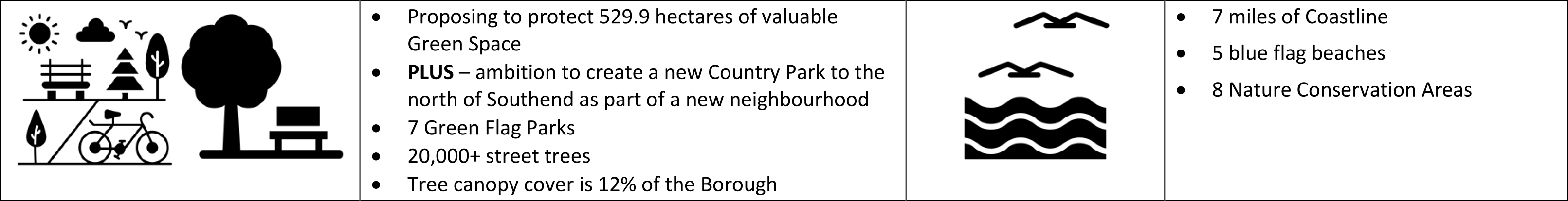
Southend on Sea has almost 600 hectares of parks and green space, including district, local and neighbourhood parks, playing fields, sports areas, allotments and woodlands, and 5 designated sites for nature conservation. Seven parks were awarded Green Flag status in 2020, reflecting the quality and variety of their offer, and 7 miles of almost continuous coastline provides an important leisure asset, with 5 Blue Flag beaches designated for 2020.
A Tree Canopy Study undertaken in 2019 found that 12% of the Borough is covered by trees, including street trees, trees within parks and open spaces, woodland, and within private gardens. The Council’s Tree Policy aims to increase this to 15% through targeted action to plant within parks, provide new street trees in areas with gaps in coverage, and in partnership with community groups and individuals to encourage more trees to be planted within gardens and other private land.
Southend is a densely developed area with limited opportunities for new green space. However, there will be opportunities to create green space where new development is proposed, including enhanced public realm, as well as improving connections between green spaces through soft landscaping, tree planting and better signage and way finding. Such small interventions can make a significant impact as part of the wider network.
ASELA, the association of South Essex local authorities, has proposed the creation of South Essex Estuary Park (SEE).* The Park will be a single regional parkland system, with multiple benefits including flood risk management and climate change mitigation, featuring a continuous and accessible coastal path from Tilbury Fort to Shoeburyness. It will boost eco-tourism and biodiversity, support a green economic recovery and provide easy access for residents to high quality green space, restored marshlands and new woodland. Continuous access to the coast for pedestrians and cyclists is also promoted through the England Coast Path** and Sustrans national cycle route.*** It also remains an ambition to improve the Cinder Path linking Leigh railway station/Old Leigh and Chalkwell Esplanade, which forms part of this strategic network to provide enhanced access for pedestrians and cyclists.
Southend’s Coastline
Southend’s blue infrastructure network includes the foreshore, which is protected as a habitat for bird species, with five internationally designated sites for nature conservation within the Borough, covering the intertidal part of the Thames Estuary. These sites support a wide range of important bird species, in particular providing overwintering feeding grounds. There are several ponds within Parks such as Priory, Friars, Southchurch and Gunners Parks, and Eastwood Brook and Prittle Brook, which provides an important link between Belfairs Woods and Priory Park as a wildlife corridor and for recreation and active travel. These will continue to be protected.
The cumulative impact of growth across South Essex is expected to increase pressure for recreational and leisure pursuits in or nearby European sites, impacting on their integrity. This impact is being addressed through the Essex Coast RAMS partnership, to implement mitigation measures to alleviate pressure on designated habitats from recreation, funded from developer contributions. While carefully managing the impacts of visitors on overwintering birds, public access to the coastline continues to be supported, including the implementation of the England Coast Path project to provide continuous coastal access for walkers and improve the quality of this route, for example with signage.
What You Told Us
In response to the New Local Plan Issues and Options document you highlighted a number of detailed issues and other matters of concern relating to parks and open spaces. These included:
- the need for a strategic approach to green and blue infrastructure as a cross-boundary issue
- the importance of greening the existing built up area, including Southend town centre and need for more tree planting, biodiversity measures, and sustainable drainage provision
- need to target any areas of green space deficiency and protect existing areas of green space
- net gain for biodiversity
- importance of green space for health and wellbeing
- climate change should feature more prominently
Climate change avoidance and mitigation is integral to the local plan and is included within the draft aim and objectives in Part 1. More detailed policies will be included in the next iteration of the plan as the Preferred Options are developed.
Protecting and enhancing Green Space
The New Local Plan therefore proposes to:
- protect green space from development;
- where justified designate green spaces of particular value to the community as ‘Local Green Space’ 61 providing them with increased special protection;
- continue to support the ambition to create a Country Park to improve access to green space for residents in the east of the Borough;
- identify areas of search/ indicative locations where new and improved green spaces will be promoted within areas lacking local access; and
- identify lower quality underutilised green spaces which provide potential for development for alternate uses.
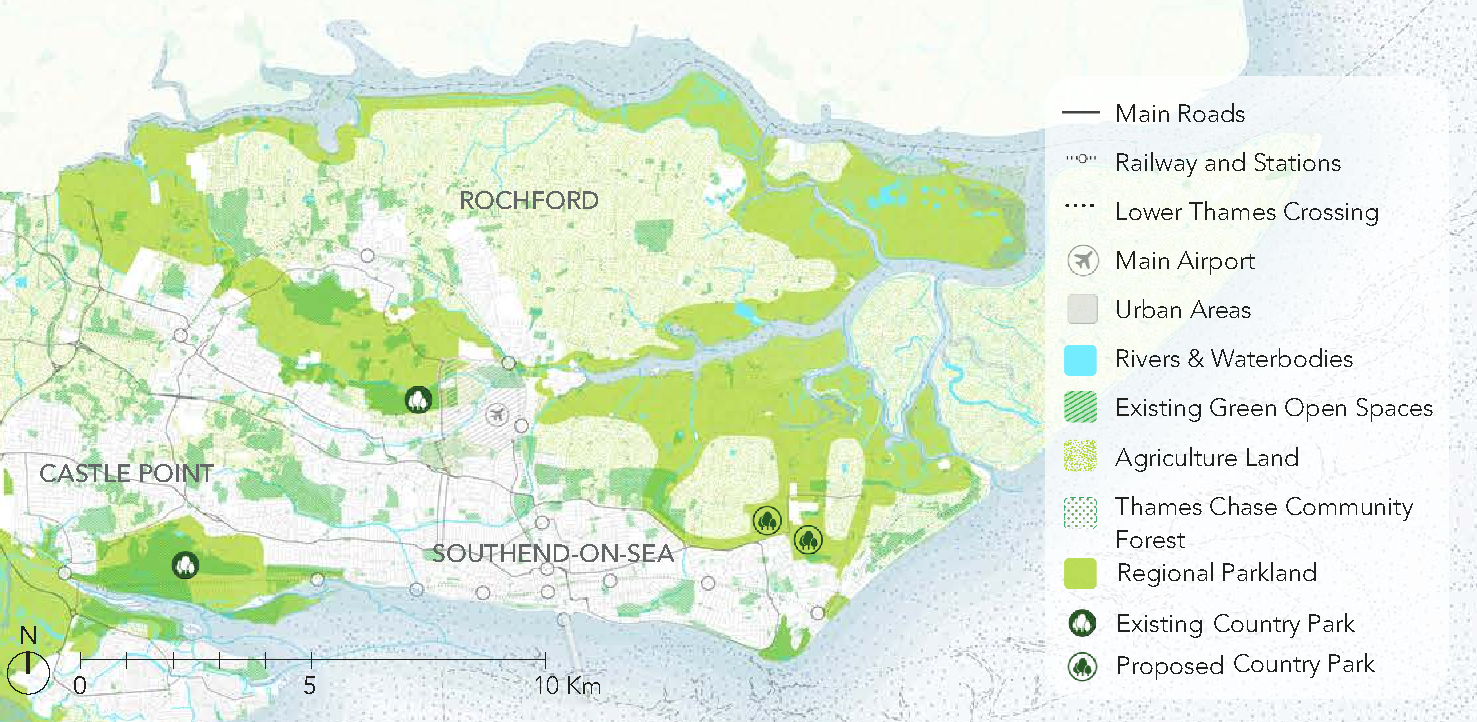
The role of new Country Parks is explored as part of the South Essex Green and Blue Infrastructure Study (2020). If a new neighbourhood or neighbourhoods were to come forward on the edge of Southend or outside the Borough as part of Development Opportunity C and/or D, this would provide the impetus to realise a long held ambition of creating a country park to the north east of Southend, which would form part of the South Essex Estuary Park. This would better connect the urban area of Southend with the rural fringes of the Crouch Estuary by linking up existing rights of way and providing greater public access to green space – see Figure 10 below. This is for indicative purposes only, and the precise extent of the country park would be determined through a master planning process, but green infrastructure provision could include community growing sites, meadowland burial provision or deliver other local priorities for green space and biodiversity. There may also be an opportunity in the longer term to create new greenways (for pedestrians, cyclists and equestrians) linking residential areas with the Roach Estuary, for example utilising the existing private road to Barling Landfill sites, Mucking Hall Road.
Figure 10 - South Essex Green and Blue Infrastructure Study (2020)
All green spaces proposed to be protected can be viewed in Appendix 2 and you can comment on them within Section 3: Neighbourhoods.
Addressing deficiencies in the quantity and quality of and access to green space
Parks and green spaces are not evenly distributed across Southend with Central Southend and Westcliff neighbourhoods having the most limited provision of green space in the Borough. It is therefore important to protect green space in such areas, to seek to provide new provision or urban greening from new developments, and to provide better connections between them to promote active travel through walking and cycling. Where there are particular gaps in access to green space these are described in the relevant neighbourhood section. All existing allotment sites will continue to be protected.
In addition, a new Country Park in the north-east of the Borough provided as part of new Neighbourhoods on the edge of Southend (see Section 2.3 above) would complement the existing facilities at Hadleigh and Cherry Orchard Jubilee Country Parks in Castle Point and Rochford, and ensure residents living within the built-up area of Southend have more equitable access to natural green space.
Releasing Existing Green Space for Housing Development
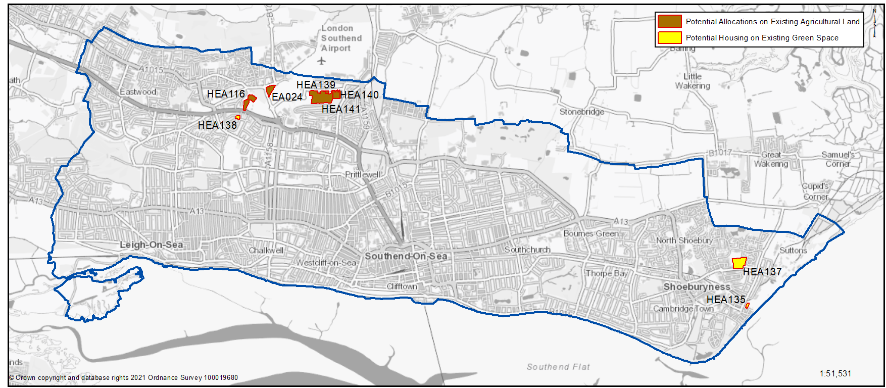
There are a number of green spaces and areas of agricultural land within the urban area that are being promoted for residential development. These are set out in Table 18 and defined in Map 12.
All sites proposed to be designated as green space or agricultural land can be viewed in Appendix A and you can comment on them within Part 3: Neighbourhoods.
Map 12: Existing Protected Green Space or Agricultural Land with the Potential for Alternative Use
What does this issue cover?
- Protecting and enhancing the wide range of parks and open spaces and coastline within the Borough, contributing to the support of mental and physical wellbeing
- Maintaining the character and integrity of the undeveloped coast
- Identifying opportunities for greater biodiversity and strengthening of green corridors throughout the urban area of Southend, promoting opportunities for active travel
- Identifying opportunities to improve and create local green space where appropriate
What information or evidence do we need for this issue?
- South Essex Blue and Green Infrastructure Study (2019)
- Southend parks and opens spaces assessment (2020)
- Essex Coast RAMS Strategy (2018)
- Tree Canopy Cover study (2019)
- Pollinator Study (2020)
Related Southend 2050 Outcomes – where we want to be
- We have invested in protecting and nurturing our coastline, which continues to be our much loved and best used asset
- More people have physically active lifestyles, including through the use of open spaces
- Our streets and public spaces are valued and support the mental and physical wellbeing of residents and visitors
- People have a wide choice of transport options
- There is a tangible sense of pride and local people are actively, and knowledgeably,talking up Southend
Question 2.6a Protecting and Enhancing Green Space and the Coastline
Have your say………Please explain your answers
You can view and comment on specific sites within Part 3: Neighbourhoods.
a. Do you support the creation of new strategic green space or a new Country Park as part of the provision of a new neighbourhood/s to the north of Southend (Figure 10)?
Table 18: Existing Protected Green Space or Agricultural Land with the Potential for Alternative Use
Individual sites displayed below. These can also be viewed via our online map
Southend-on-Sea Borough Council – Local Plan: Map 3 Green Spaces (opus4.co.uk)
Question 2.6b Protecting and Enhancing Green Space and the Coastline
HEA138 Land at Mendip Crescent/ Dunster Avenue
Description: Green Space
Potential Alternative Use: Residential. Tree planting on the remaining green space. A programme of tree planting has begun on the site which has been identified as having potential for woodland as part of the corporate strategy to increase canopy cover in the Borough.
Neighbourhood Area: Leigh
Area (Ha): 0.39
Justification: Land is in public ownership and underutilised, with potential for residential development.
Question b. Do you agree with the green space sites / agricultural land identified as having the potential to be released for development (Table 18 and Map 12)? Please explain your answer.
Question 2.6b Protecting and Enhancing Green Space and the Coastline
HEA137 Land at Elm Road
Description: Green Space
Potential Alternative Use: Residential. Tree planting on the remaining green space would increase biodiversity. There is an existing programme of managing the habitat with controlled cutting regimes to increase biodiversity. Site remediation would also be required..
Neighbourhood Area: Shoeburyness
Area (Ha): 3.77
Justification: Land is in public ownership and underutilised, with potential for residential development.
Question b. Do you agree with the green space sites / agricultural land identified as having the potential to be released for development (Table 18 and Map 12)? Please explain your answer.
Question 2.6b Protecting and Enhancing Green Space and the Coastline
HEA135 Land at George Street
Description: Green Space, former playing field associated with Hinguar School. Covenant issues on land
Potential Alternative Use: Residential, potential to enhance adjacent East Beach recreational / environmental offer
Neighbourhood Area: Shoeburyness
Area (Ha): 0.32
Justification: Land is in public ownership and underutilised, with potential for residential development.
Question b. Do you agree with the green space sites / agricultural land identified as having the potential to be released for development (Table 18 and Map 12)? Please explain your answer.
Question 2.6b Protecting and Enhancing Green Space and the Coastline
HEA141 Land South of Eastwoodbury Lane
Description: Agricultural Land
Potential Alternative Use: New transport access, school, residential, improvements to remaining green space
Neighbourhood Area: Eastwood
Area (Ha): 7.17
Justification: Land is in public ownership and underutilised, with potential for residential development.
Question b. Do you agree with the green space sites / agricultural land identified as having the potential to be released for development (Table 18 and Map 12)? Please explain your answer.
Question 2.6b Protecting and Enhancing Green Space and the Coastline
HEA140 Land South of Eastwoodbury Lane
Description: Small Holdings
Potential Alternative Use: Residential, improvements to remaining green space
Neighbourhood Area: Prittlewell
Area (Ha): 1.63
Justification: Land is in public ownership and underutilised, with potential for residential development.
Question b. Do you agree with the green space sites / agricultural land identified as having the potential to be released for development (Table 18 and Map 12)? Please explain your answer.
Question 2.6b Protecting and Enhancing Green Space and the Coastline
HEA139 Land South of Eastwoodbury Lane
Description: Small Holdings
Potential Alternative Use: Residential.
Neighbourhood Area: Prittlewell
Area (Ha): 0.21
Justification: Land is in public ownership and underutilised, with potential for residential development.
Question b. Do you agree with the green space sites / agricultural land identified as having the potential to be released for development (Table 18 and Map 12)? Please explain your answer.
Question 2.6b Protecting and Enhancing Green Space and the Coastline
HEA116 Land at Brendon Way/ North of Prince Close
Description: Agricultural Land
Potential Alternative Use: Residential.
Neighbourhood Area: Prittlewell
Area (Ha): 2.45
Justification: Land is in public ownership and underutilised, with potential for residential development.
Question b. Do you agree with the green space sites / agricultural land identified as having the potential to be released for development (Table 18 and Map 12)? Please explain your answer.
Question 2.6b Protecting and Enhancing Green Space and the Coastline
EA024 Land at Nestuda Way/ Eastwoodbury Lane
Description: Agricultural Land
Potential Alternative Use: Residential.
Neighbourhood Area: Eastwood
Area (Ha): 1.56
Justification: Land is in public ownership and underutilised, with potential for residential development.
Question b. Do you agree with the green space sites / agricultural land identified as having the potential to be released for development (Table 18 and Map 12)? Please explain your answer.
|
Map Ref. |
Site |
Description |
Potential Alternative use |
Neighbourhood Area |
Area (Ha) |
Justification |
|
Please note additional sites are being promoted on agricultural land as part of the provision of a new neighbourhood on the edge of Southend – please see section 2.3 |
||||||
|
Total |
17.5 |
|||||
Question 2.6c Protecting and Enhancing Green Space and the Coastline
Question c. Do you agree with the approach to protecting designated coastal habitats and supporting public access to the coast? Please explain your answer.
Question 2.6d Protecting and Enhancing Green Space and the Coastline
Question d. Do you have any other comments on our proposed approach to green space policy?