The ‘Broad Type of Sites’ (Strategy Option Components) make up the different Strategy Options set out above, and consist of individual sites that are being promoted to us for development and have been grouped for analysis (see Map 3).
We are interested in your views on the merits and disadvantages of each ‘Broad Type of Site’.
To view and comment on individual sites please refer to Part 3: Neighbourhoods. You can also use the interactive mapping tool via the New Local Plan website - localplan.southend.gov.uk/
Sites with planning permission can be viewed on Map 3. They are not the focus of this consultation, although it is proposed that such sites will also be allocated if they have not been implemented before we finalise the New Local Plan.
Map 3 – Components of Growth: Spatial distribution of Broad Type of Sites (Strategy Option Components)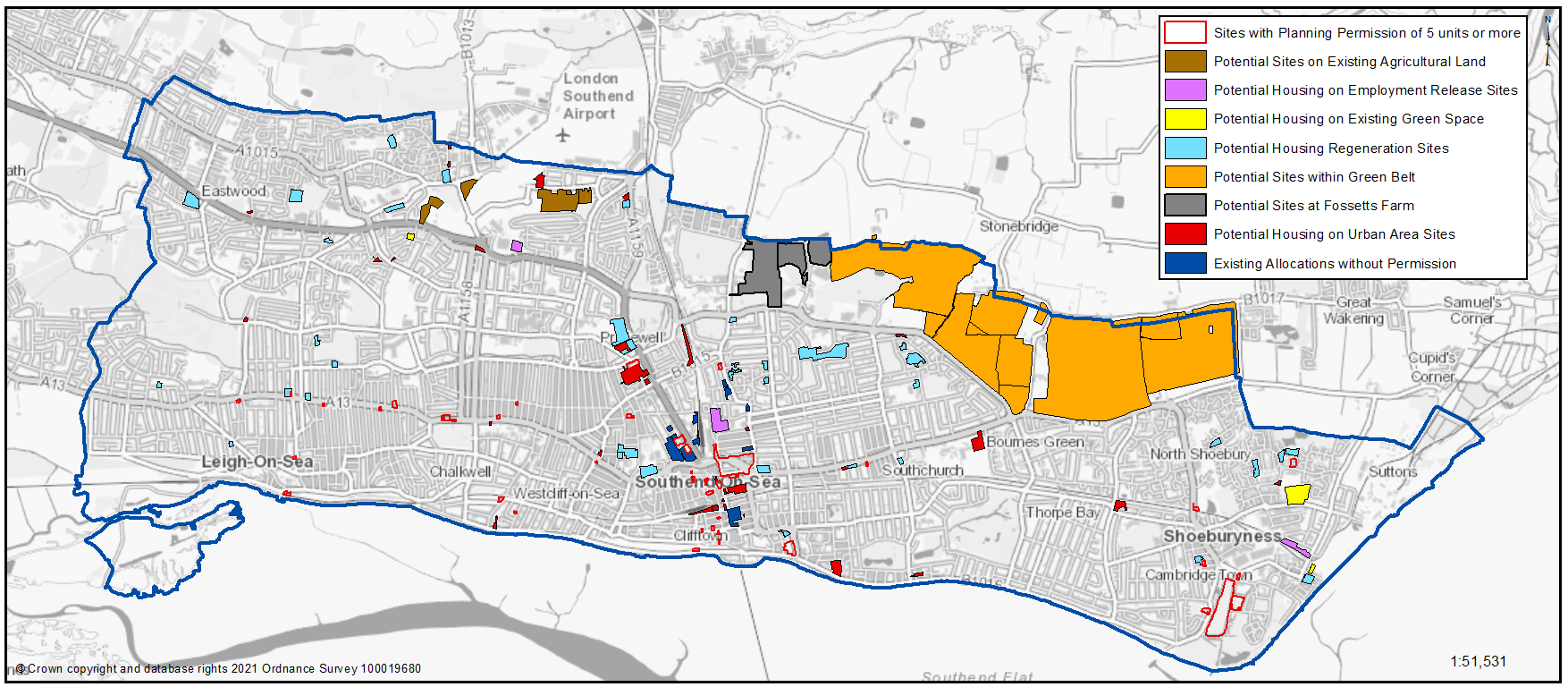
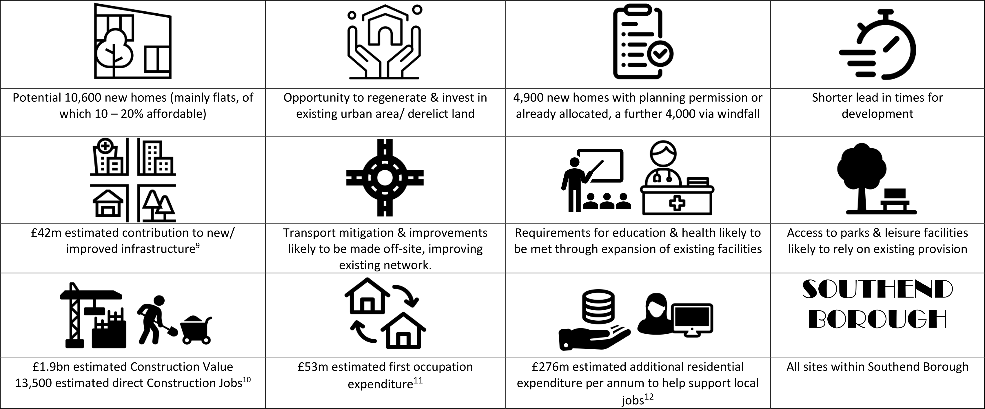
Strategy Option A: Increasing Urban Capacity
Headlines - Strategy Option A
9.Assumes S106 of £1,400 per dwellings, averaged CIL rate of £50per sqm, average size of dwellings size of 65sqm, 20% affordable housing 10. Assumes average house size of 100sqm, BCIS Jan 2021 for Southend £/sqm, 30% affordable housing; construction turnover per worker based on ONS Annual Business Survey 11.Assumes £5,000 per dwelling; resident expenditure based on ONS Family Spending Survey (all households) 12. Assumes average household size of 2.5 persons, resident expenditure based on ONS Family Spending Survey (all households)
Broad Type of Sites – Strategy Option A
This comprises development within the existing urban area of Southend and includes windfall, existing planning permissions, existing allocations and sites located on previously developed land. The delivery of sites under this scenario is broadly compliant with existing planning policy.
Baseline included in all Options
Windfall (Baseline)
Windfall sites* are those that are not specifically identified from the outset in the Local Plan. They normally comprise previously developed land that has unexpectedly become available. These could include, for example, large sites resulting from an unforeseen factory closure or small sites such as a residential conversion or a new flat over a shop.
As Southend is almost exclusively urban, it is inevitable that there will be further intensification of the existing urban area and a continual supply of land and buildings reaching the end of their useful life in their current use that may be suitable for residential use or redevelopment. Such developments assist with regeneration, urban renewal and inward investment but must conform with development management and design led policies to ensure there is not a detrimental impact on the local area.
Based on analysis of historic and future trends and ensuring there is no double counting with sites listed below, it is estimated that around 4,000 new homes can be provided through windfall development over the next 20 years.
*Windfall can include permitted development that does not require planning permission, and therefore, the Borough Council has limited influence on managing such development.
Permitted Sites (Baseline)
Around 3,700 homes can be delivered from Sites with Planning Permission and are not the focus of this consultation.
Strategy Option A
Existing Allocated Sites (Strategy Option A)
Sites without permission but allocated in the Southend Central Area Action Plan (SCAAP) adopted in 2018, where the principle for development has already been set and therefore should be included within the New Local Plan.
Urban Area Sites (Strategy Option A)
Not currently allocated in the SCAAP, which sit within the existing urban area of the Borough and have development potential. Most will be characterised as previously developed land. The Government supports the redevelopment of such sites to assist urban renewal, ensuring the efficient use of land as well as providing for additional homes.
Map 4: Strategy Option A: Increasing Urban Capacity* – Broad Type of Sites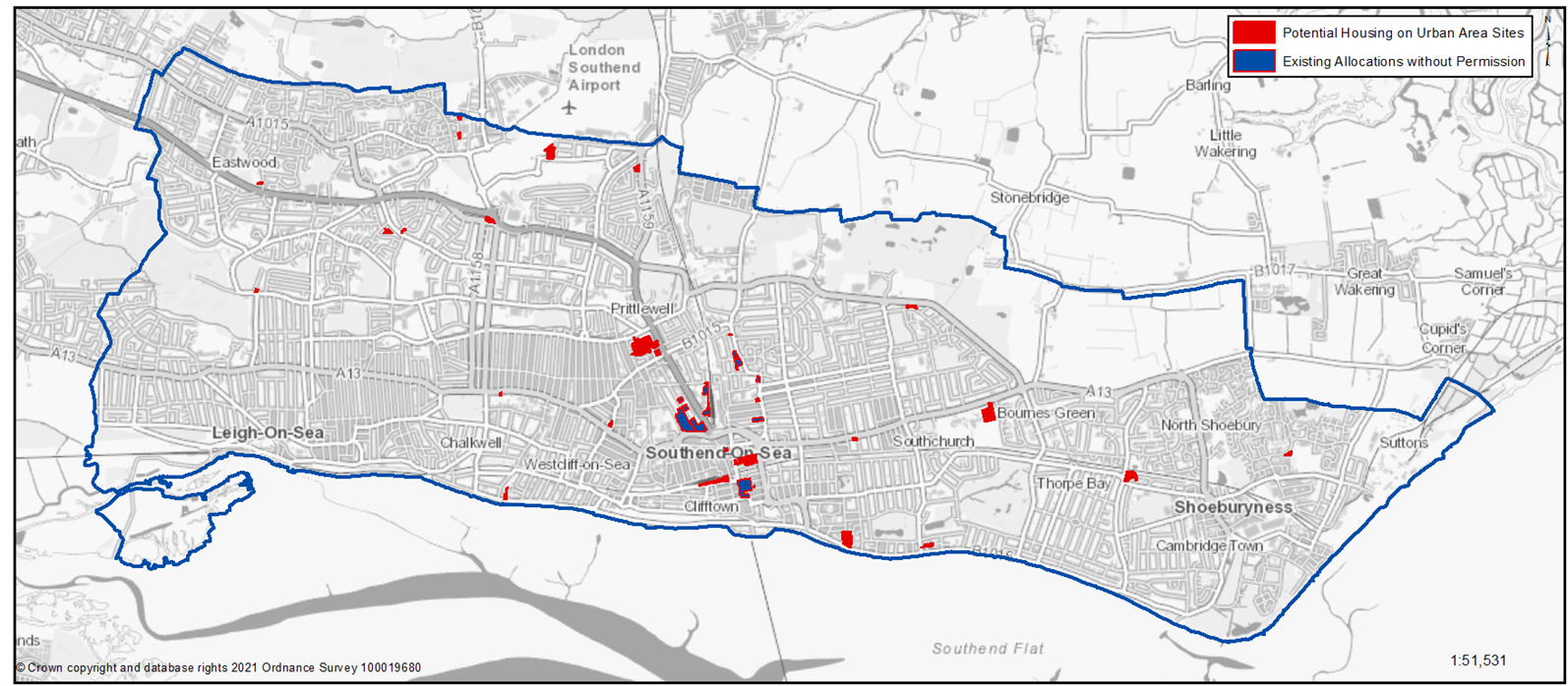
*Does not depict those sites with planning permission – please refer to Appendix 1 to view sites with planning permission.
Table 7: Increasing Urban Capacity
|
Component of Strategy Option |
Number of new sites as part of Local Plan |
Total number of sites |
Total number of potential new homes |
|---|---|---|---|
|
Sites with planning permission on small sites (less than 5 homes) or those being implemented as of April 2019 |
0 |
225 |
1,000 |
|
Sites with planning permission on large sites (5 homes or more) |
0 |
47 |
2,700 |
|
Existing Allocated Sites |
0 |
13 |
1,200 |
|
Urban Area Sites |
33 |
33 |
1,700 |
|
Windfall |
4,000 |
||
|
Total |
33 |
318 |
10,618 |
To view and comment on individual sites please refer to Part 3: Neighbourhoods. You can also use the interactive mapping tool via the New Local Plan website - localplan.southend.gov.uk/
Question - 2.3a Providing New Homes: Broad Type of Sites Strategy Option A: Increasing Urban Capacity
Have your say……… Please explain your answers
You can view and comment on specific sites within Section 3: Neighbourhoods
a) The Southend Central Area Action Plan, adopted in 2018, includes a number of Existing Allocated Sites. It is proposed that the New Local Plan will continue to allocate these sites for development. Do you agree with this approach? Please explain your answer.
b) Government supports the development of Urban Area Sites and these should therefore be included within the New Local Plan. Do you have any comment to make regarding this? Please explain your answer.
Strategy Option B: Facilitating Urban Change
Headlines - Strategy Option B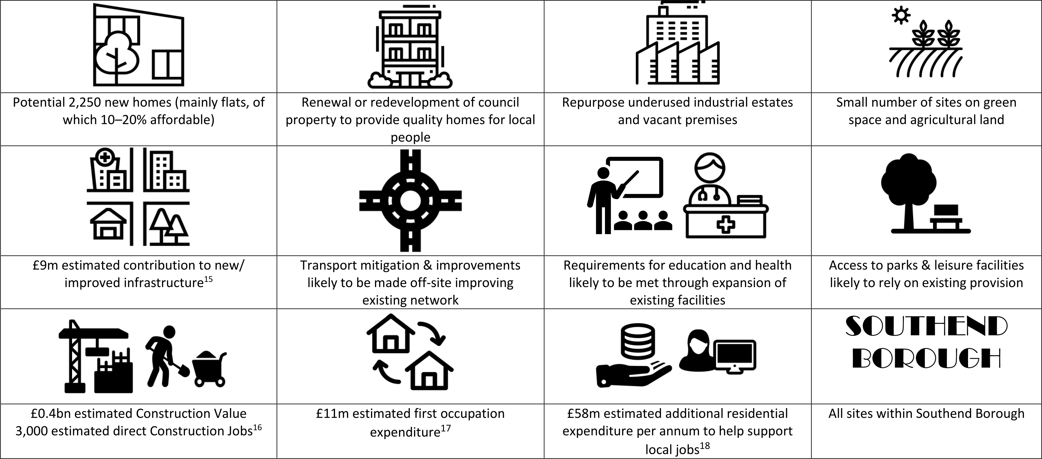
[15] Assumes S106 of £1,400 per dwellings, averaged CIL rate of £50per sqm, average size of dwellings size of 65sqm, 20% affordable housing [16] Assumes average house size of 100sqm, BCIS Jan 2021 for Southend £/sqm, 30% affordable housing; construction turnover per worker based on ONS Annual Business Survey [17] Assumes £5,000 per dwelling; resident expenditure based on ONS Family Spending Survey (all households) [18] Assumes average household size of 2.5 persons, resident expenditure based on ONS Family Spending Survey (all households)
Broad Type of Sites – Strategy Option B
In addition to the above (Strategy Option A), there are other opportunities for facilitating urban change which could contribute further to meeting future housing needs. These all comprise sites submitted to us as part of New Local Plan process and include Housing Regeneration Sites, Underused Employment Release Sites, Sites on Green Space and Agricultural Land within the urban area.
The delivery of sites under this scenario will broadly rely on review of existing planning policy as part of the New Local Plan. See Map 5 and Table 8.
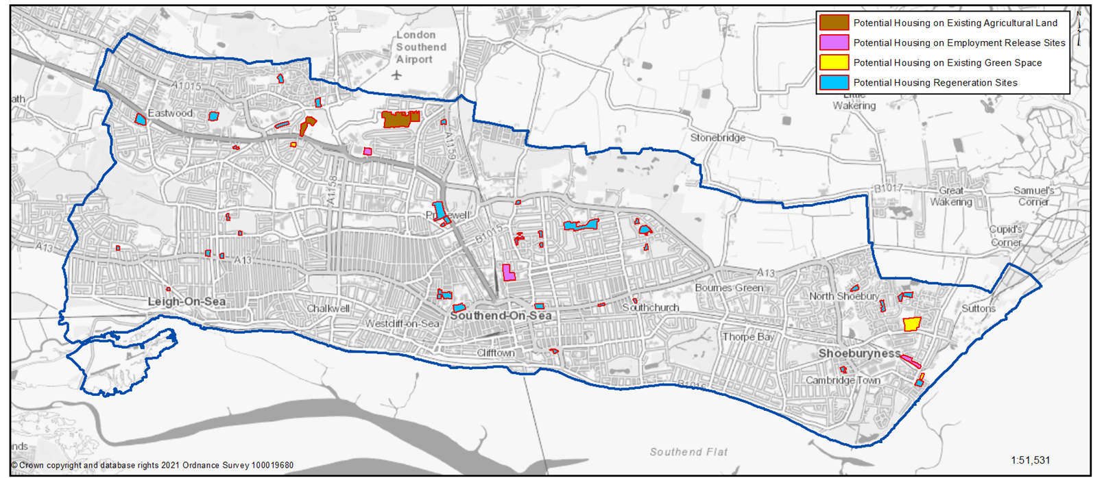
Housing Regeneration Sites (Strategy Option B)
Located on existing housing estates in public ownership that may benefit from some renewal, redevelopment or expansion to help assist in regenerating the area, providing quality homes for local people, including meeting the needs of an ageing population so residents can remain living in the community.
To gain a comprehensive understanding of development potential, all existing housing estates in public ownership have been included for comment. At the time of publication of this document no Council decision has been made on redeveloping any of these sites unless the site is already allocated or has planning permission, for example Better Queensway.
Underused Employment Land Release Sites (Strategy Option B)
Located on outmoded/ underused employment land that could be put to alternative residential use by providing additional new homes that relate better to nearby existing residential properties and may include an element of new commercial floorspace. Includes 3 sites: Grainger, Prince Avenue and Terminal Close Industrial Estates that experience high vacancy rates.
Sites on Agricultural Land within existing settlement limits (Strategy Option B)
Located on land identified as agricultural land or smallholdings in the Eastwoodbury Lane area have a strategic importance as they could provide an additional link between the A127, London Southend Airport/Rochford Road and the east of the Borough, providing resilience to Cuckoo Corner and Fossetts Farm, as well as having potential for some additional housing, education facilities and enhanced public open space.
Sites on Green Space within existing settlement limits (Strategy Option B)
Located on undeveloped land currently designated as protected green space. The sites, identified as having potential for partial or full redevelopment for housing, represent approximately 1% of all the protected green space in the Borough.
Map 5: Strategy Option B: Facilitating Urban Change* – Broad Type of Sites
*Does not depict those sites with planning permission – please refer to Appendix A to view sites with planning permission
Table 8: Increasing Urban Capacity Sites
| Component of Strategy Options | Number of sites as part of the Local Plan | Total number of potential new homes |
|---|---|---|
| Housing Regeneration Sites | 40 | 850 |
| Employment Land Release Sites | 4 | 750 |
| Agricultural Land within Settlement Limits | 5 | 350 |
| Site on Green Space within Settlement Limits | 3 | 300 |
| Total | 52 | 2,250 |
Question - 2.3b Providing New Homes: Broad Type of Sites Strategy Option B: Facilitating Urban Change
Have your say……… Please explain your answers
You can view and comment on specific sites within Part 3: Neighbourhoods or via the website
a) Do you support the principle of allocating Housing Regeneration Sites for housing led redevelopment, as shown on Map 5 and Table 8?
b) Do you support the principle of allocating Employment Land Release Sites for housing led redevelopment, as shown on Map 5 and Table 8?
c) Do you support the principle of allocating a small number of sites that are currently located on public Green Space for housing led redevelopment, as shown on Map 5 and Table 8?
d) Do you support the principle of allocating a small number of sites that are currently located on Agricultural Land for housing led redevelopment, as shown on Map 5 and Table 8?
Strategy Option C: New Neighbourhood to the north of Southend
Headlines - Strategy Option C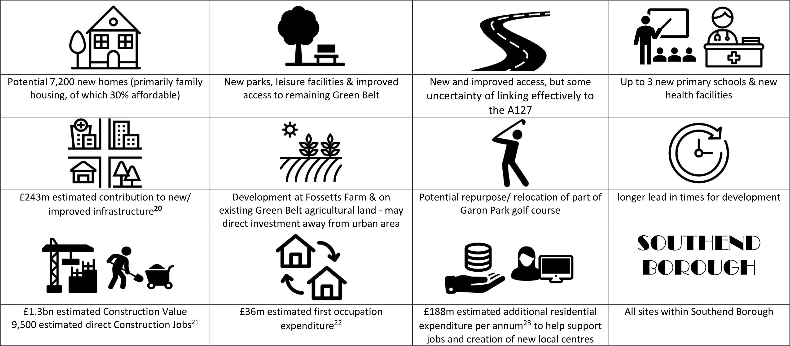
[20] Assumes S106 of £30,000 per dwellings, averaged CIL rate of £50per sqm, average size of dwelling 100sqm, 30% affordable housing [21] Assumes average house size of 100sqm, BCIS Jan 2021 for Southend £/sqm, 30% affordable housing; construction turnover per worker based on ONS Annual Business Survey [22] Assumes £5,000 per dwelling; resident expenditure based on ONS Family Spending Survey (all households) [23] Assumes average household size of 2.5 persons, resident expenditure based on ONS Family Spending Survey (all households)
Broad Type of Sites – Strategy Option C
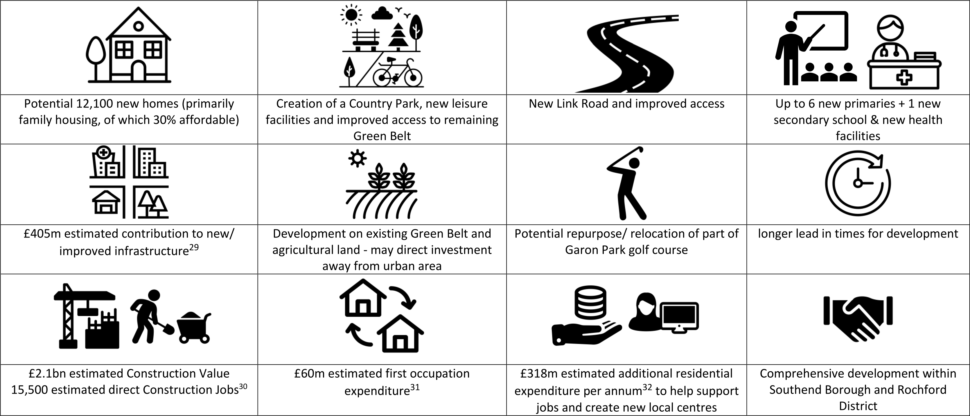
Development on the edge of the existing urban area of Southend has the potential to create a comprehensive new neighbourhood including new jobs, supporting infrastructure, parkland and green space. This includes 1,850 new homes at Fossetts Farm and an estimated 5,350 additional homes on land currently designated as Green Belt (Table 9). The delivery of sites currently designated as Green Belt will rely on review of existing planning policy as part of the New Local Plan.
Table 9: New Neighbourhood on the edge of Southend
| Component of Strategy Option | Number of sites as part of Local Plan | Total number of potential new homes |
|---|---|---|
| Fossett Farm Sites | 4 | 1,850 |
| Sites within Green Belt on the edge of Southend | 11 | 5,350 |
| Total | 15 | 7,200 |
New Neighbourhood on the edge of Southend
To facilitate the delivery of a new neighbourhood, a range of complimentary services and other uses would be required, including but not limited to improved transport and access, new schools, health facilities, parkland and green space and other supporting infrastructure.
To aid consultation feedback Figure 8 provides an indicative sketch of what a new neighbourhood on the edge of Southend could look like for illustrative purposes only. This has been submitted to the Borough Council by the site promoters and is available on the Council’s website*.
Figure 8 - Indicative Concept of Potential New Neighbourhood within Southend Borough (Development Opportunity C)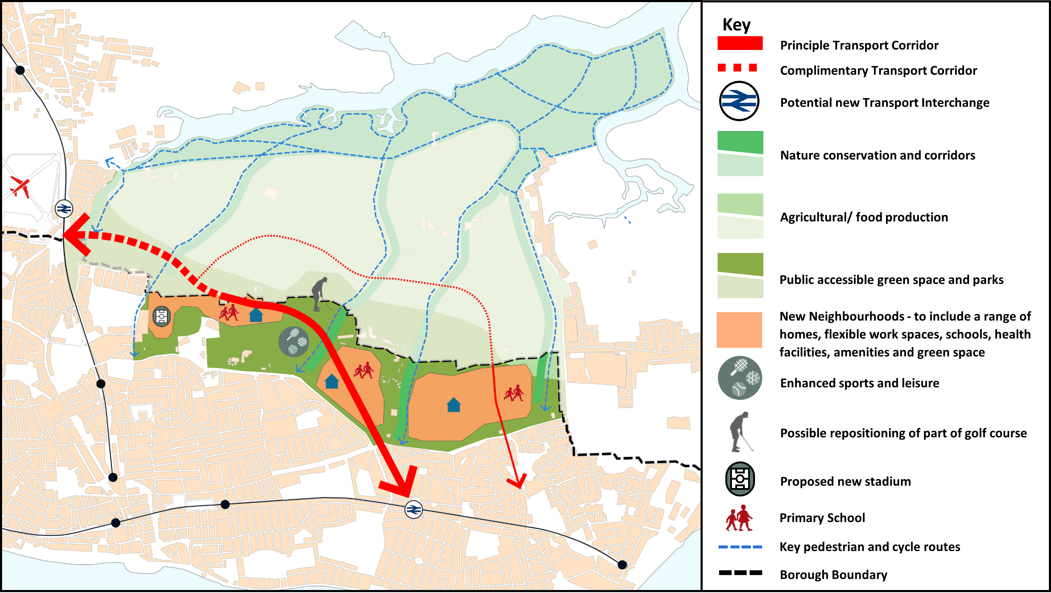
Diagram submitted to the Borough Council as evidence - ‘Potential growth options in Rochford and Southend – Proof of Concept’ (2021) Iceni on behalf of Cogent Land
The provision of new road links will be essential to deliver a new neighbourhood on the edge of Southend, along with other upgrades to the existing transport network. For any road link to be effective it is likely that part of the route would need be located within Rochford District. As Strategy Option C only considers land within Southend Borough, effective co-operation would be required with neighbouring Rochford District Council and the transport authority, Essex County Council, to bring forward comprehensive improvements to the transport network within both administrative areas.
Please refer to the Section 2.7: Transport and Access for more information and to comment on potential new road links.
The easiest and simplest way to view and comment on the document and proposed sites is by visiting the Council’s interactive mapping tool.
Question 2.3c Providing New Homes - Development Opportunity C: New Neighbourhood
a. Do you support the principle of providing a new neighbourhood on the edge of Southend (Figure 8) to provide for comprehensive development to include new homes and family housing, jobs, improved public green space and access, community services and supporting infrastructure?
b. If a new neighbourhood came forward on the edge of Southend do you have a view on what our priorities should be – e.g. what types of services, open green spaces and infrastructure should be prioritised? Please explain your answer and let us know what you think the priorities should be.
c Do you agree that there are opportunities to ensure any new development successfully integrates with existing communities, town and local centres and the wider transport network? Please explain your answer.
Sites at Fossett’s Farm (Strategy Options C & D)
In total around 1,800 new homes, a new football stadium and other supporting uses are being promoted across 4 sites at Fossetts Farm on land currently designated as Safeguarded Land for future development (post 2021).* Three of these sites are at advanced planning stage where permission could be granted this year.
*Southend Borough Local Plan Second Alteration 1997
Map 6: Potential Land Use Proposals at Fossetts Farm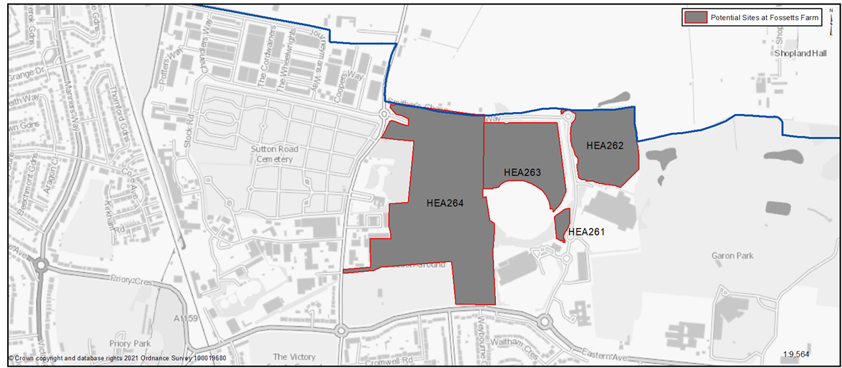
Table 10: Potential Land Use Proposals at Fossetts Farm
Question 2.3c.d Providing New Homes - Development Opportunity C: New Neighbourhood
HEA261 Land West of Fossetts Way
Context and Surrounding Uses: A vacant site adjacent to Fossetts Way with an ancient monument (archaeological) to the west.
Proposed Land Use: Residential Led
Potential Estimated number of homes: Gross 46 Net 46
| https://localplan.southend.gov.uk/sites/localplan.southend/files/2021-08/North%20of%20Southend%20Proformas.pdf#page=12 |
Question 2.3c.d - Do you support the allocation of this site at Fossetts Farm?
Question 2.3c.d Providing New Homes - Development Opportunity C: New Neighbourhood
HEA262 Land East of Fossetts Way
Context and Surrounding Uses: A vacant site adjacent to Fossetts Way, with a trading estate to the south, and a golf course to the east.
Proposed Land Use: Residential Led
Potential Estimated number of homes: Gross 221 Net 221
| https://localplan.southend.gov.uk/sites/localplan.southend/files/2021-08/North%20of%20Southend%20Proformas.pdf#page=13 |
Question 2.3c.d - Do you support the allocation of this site at Fossetts Farm?
Question 2.3c.d Providing New Homes - Development Opportunity C: New Neighbourhood
HEA263 A vacant site adjacent to Fossetts Way, with an ancient monument (archaeological) to the south.
Context and Surrounding Uses: A vacant site adjacent to Fossetts Way, with an ancient monument (archaeological) to the south.
Proposed Land Use: Residential Led
Potential Estimated number of homes: Gross 131 Net 131
| https://localplan.southend.gov.uk/sites/localplan.southend/files/2021-08/North%20of%20Southend%20Proformas.pdf#page=14 |
Question 2.3c.d - Do you support the allocation of this site at Fossetts Farm?
Question 2.3c.d Providing New Homes - Development Opportunity C: New Neighbourhood
HEA264 SUFC Training Ground Eastern Avenue
Context and Surrounding Uses: A large parcel of land that sites the former Southend United training ground and playing pitches, with the majority of the site currently vacant. An ancient monument (archaeological) is located to the east.
Proposed Land Use: Football stadium and supporting uses including residential
Potential Estimated number of homes: Gross 1,461 Net 1,461
| https://localplan.southend.gov.uk/sites/localplan.southend/files/2021-08/North%20of%20Southend%20Proformas.pdf#page=15 |
Question 2.3c.d - Do you support the allocation of this site at Fossetts Farm?
| Potential Estimated number of homes (Net) | |
|---|---|
| Total | 1,859 |
Sites within Green Belt on the edge of Southend
Green Belt is a national planning policy designation to check the sprawl of large built-up areas, prevent towns merging into each other, stop encroachment into the countryside, protect the setting and special character of historic towns and assist in urban regeneration by focussing development in urban areas. Southend has areas of Green Belt around its north and western edges, which form part of the extensive Metropolitan Green Belt stretching from the borders of east London across South Essex.
A change to Green Belt boundaries should only be made through the Local Plan process and in exceptional circumstances, for example when development needs cannot be met within the existing urban area or on land not designated as Green Belt, and when release would promote sustainable patterns of development. Table 6 above clearly demonstrates that there will be a substantial deficit in the supply of new homes when considered against needs* over the next 20 years if areas of green belt land is not developed. It is therefore important that the existing Green Belt designation to the north of Southend is reviewed to assess its continuing contribution to the stated purposes of Green Belt and whether parts of it would be more appropriately allocated for sustainable development to meet future needs.
As part of the ‘call for sites’ ** process a number of sites, currently in agricultural use and designated as Green Belt on the northern edge of Southend, are being promoted for development by the landowners/agents. Table 11 and Map 7 show the individual land parcels located on existing Green Belt land being promoted for development as part of a new neighbourhood/s on the edge of Southend.
The Green Belt Study*** found that the majority of this land continues to serve the stated purposes of the Green Belt well, in particular by maintaining the openness of the countryside. However, it identifies a number of pockets of land adjacent to the existing urban edges that make a weaker contribution to the stated purposes of the Green Belt.
Harm to the Green Belt is only one factor that needs to be considered when establishing whether the necessary exceptional circumstances for release exist. Whilst the ideal would be to minimise harm to the Green Belt, it may be that sites resulting in higher harm to the Green Belt purposes are released if they promote sustainable patterns of development to help meet the economic, social and environmental objectives of the planning system. For example, this might be through delivering a comprehensive new neighbourhood/s with supporting infrastructure. A judgement will therefore be required to establish on balance the most suitable sites to meet the needs of the Borough for this plan period and beyond.
If land were to be considered suitable for release from the Green Belt it will be important to ensure that mitigation measures are put in place as an integral part of the development process. These could include:
- extensive landscaping and the provision of open space to help integrate the scheme into the surrounding countryside;
- designing development and landscaping measures so as to create a new definable and defensible Green Belt boundary;
- creating a visually staged transition from urban to rural, using built density, height, materials and landscaping to create a more permeable edge to the development;
- enhancing public access to the surrounding countryside;
- promoting the development of a new Country Park to the north-east of Southend to compensate for the loss of Green Belt;
- maintaining separation between existing and new settlements, particularly with Rochford;
- if land is released from the Green Belt then first consideration should be given to land that is well served by public transport;
- designing road infrastructure so as to limit the perception of increased urbanisation associated with new development.
*As per the Government Standard methodology
Map 7: Land Use Proposals on Green Belt Land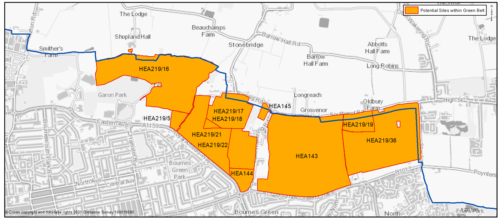
Table 11: Land Use Proposals on the edge of Southend currently designated as Green Belt
Sites currently designated as Green Belt:
2.3c.e Providing New Homes: Broad Type of Sites Strategy Option C: New Neighbourhood
HEA219/16
Existing use, access and site context: The site is currently used as part of golf course, with a golf complex located at the centre of the site.
Area (Ha): 61.12
Proposed Use: Delivered as part of a new neighbourhood/s comprising new homes, public green space, access and supporting infrastructure and services
| https://localplan.southend.gov.uk/sites/localplan.southend/files/2021-08/North%20of%20Southend%20Proformas.pdf#page=4 |
Question 2.3c.e. Do you support the allocation of this site in the Green Belt to deliver a New Neighbourhood, comprising housing, jobs, improved public green space and access, community services and supporting infrastructure?
2.3c.e Providing New Homes: Broad Type of Sites Strategy Option C: New Neighbourhood
HEA219/5
Existing use, access and site context: This site is currently in use as part of the existing golf course and is bordered on the western edge by the A1159.
Area (Ha): 3.34
Proposed Use: Delivered as part of a new neighbourhood/s comprising new homes, public green space, access and supporting infrastructure and services
| https://localplan.southend.gov.uk/sites/localplan.southend/files/2021-08/North%20of%20Southend%20Proformas.pdf#page=11 |
Question 2.3c.e. Do you support the allocation of this site in the Green Belt to deliver a New Neighbourhood, comprising housing, jobs, improved public green space and access, community services and supporting infrastructure?
2.3c.e Providing New Homes: Broad Type of Sites Strategy Option C: New Neighbourhood
HEA219/21
Existing use, access and site context: The site is currently used as part of a golf course, adjacent to agricultural land to the east and the wider golf course to the west.
Area (Ha): 28.55
Proposed Use: Delivered as part of a new neighbourhood/s comprising new homes, public green space, access and supporting infrastructure and services
| https://localplan.southend.gov.uk/sites/localplan.southend/files/2021-08/North%20of%20Southend%20Proformas.pdf#page=8 |
Question 2.3c.e. Do you support the allocation of this site in the Green Belt to deliver a New Neighbourhood, comprising housing, jobs, improved public green space and access, community services and supporting infrastructure?
2.3c.e Providing New Homes: Broad Type of Sites Strategy Option C: New Neighbourhood
HEA219/18
Existing use, access and site context: The site is currently used as part of a golf course, adjacent to agricultural land to the east and the wider golf course to the west.
Area (Ha): 1.41
Proposed Use: Delivered as part of a new neighbourhood/s comprising new homes, public green space, access and supporting infrastructure and services
| https://localplan.southend.gov.uk/sites/localplan.southend/files/2021-08/North%20of%20Southend%20Proformas.pdf#page=6 |
Question 2.3c.e. Do you support the allocation of this site in the Green Belt to deliver a New Neighbourhood, comprising housing, jobs, improved public green space and access, community services and supporting infrastructure?
2.3c.e Providing New Homes: Broad Type of Sites Strategy Option C: New Neighbourhood
HEA219/17
Existing use, access and site context: Currently in agricultural use located adjacent to the golf course and bordered on the north by residential dwellings that sit alongside Barling Road.
Area (Ha): 18.81
Proposed Use: Delivered as part of a new neighbourhood/s comprising new homes, public green space, access and supporting infrastructure and services
| https://localplan.southend.gov.uk/sites/localplan.southend/files/2021-08/North%20of%20Southend%20Proformas.pdf#page=5 |
Question 2.3c.e. Do you support the allocation of this site in the Green Belt to deliver a New Neighbourhood, comprising housing, jobs, improved public green space and access, community services and supporting infrastructure?
2.3c.e Providing New Homes: Broad Type of Sites Strategy Option C: New Neighbourhood
HEA219/22
Existing use, access and site context: The site is currently in agricultural use, with the golf course to the west. The eastern edge is bounded by Wakering Road.
Area (Ha): 14.94
Proposed Use: Delivered as part of a new neighbourhood/s comprising new homes, public green space, access and supporting infrastructure and services
| https://localplan.southend.gov.uk/sites/localplan.southend/files/2021-08/North%20of%20Southend%20Proformas.pdf#page=9 |
Question 2.3c.e. Do you support the allocation of this site in the Green Belt to deliver a New Neighbourhood, comprising housing, jobs, improved public green space and access, community services and supporting infrastructure?
2.3c.e Providing New Homes: Broad Type of Sites Strategy Option C: New Neighbourhood
HEA144
Existing use, access and site context: Agricultural land bordered to the east by Wakering Road. Bordered to the west by the A1159 and golf course
Area (Ha): 5.91
Proposed Use: Delivered as part of a new neighbourhood/s comprising new homes, public green space, access and supporting infrastructure and services
| https://localplan.southend.gov.uk/sites/localplan.southend/files/2021-08/North%20of%20Southend%20Proformas.pdf#page=2 |
Question 2.3c.e. Do you support the allocation of this site in the Green Belt to deliver a New Neighbourhood, comprising housing, jobs, improved public green space and access, community services and supporting infrastructure?
2.3c.e Providing New Homes: Broad Type of Sites Strategy Option C: New Neighbourhood
HEA145
Existing use, access and site context: On the outskirts of Southend, currently in use as a horticultural nursery by the Council. Mix of uses in surrounding area, which is largely open, including agricultural and residential.
Area (Ha): 1.75
Proposed Use: Delivered as part of a new neighbourhood/s comprising new homes, public green space, access and supporting infrastructure and services
| https://localplan.southend.gov.uk/sites/localplan.southend/files/2021-08/North%20of%20Southend%20Proformas.pdf#page=3 |
Question 2.3c.e. Do you support the allocation of this site in the Green Belt to deliver a New Neighbourhood, comprising housing, jobs, improved public green space and access, community services and supporting infrastructure?
2.3c.e Providing New Homes: Broad Type of Sites Strategy Option C: New Neighbourhood
HEA143
Existing use, access and site context: Agricultural land bordered to the north by Southend Road. Bordered to the west by Wakering Road, Alleyn Court School and Thorpe Hall School. Bordered to the south by Bournes Green Chase which is the boundary the urban area of Southend
Area (Ha): 91.5
Proposed Use: Delivered as part of a new neighbourhood/s comprising new homes, public green space, access and supporting infrastructure and services
| https://localplan.southend.gov.uk/sites/localplan.southend/files/2021-08/North%20of%20Southend%20Proformas.pdf#page=1 |
Question 2.3c.e. Do you support the allocation of this site in the Green Belt to deliver a New Neighbourhood, comprising housing, jobs, improved public green space and access, community services and supporting infrastructure?
HEA219/19
Existing use, access and site context: Agricultural land located west of Great Wakering. The site is greenfield, however is located opposite a number of light industrial units.
Area (Ha): 8.57
Proposed Use: Delivered as part of a new neighbourhood/s comprising new homes, public green space, access and supporting infrastructure and services
| https://localplan.southend.gov.uk/sites/localplan.southend/files/2021-08/North%20of%20Southend%20Proformas.pdf#page=7 |
Question 2.3c.e. Do you support the allocation of this site in the Green Belt to deliver a New Neighbourhood, comprising housing, jobs, improved public green space and access, community services and supporting infrastructure?
2.3c.e Providing New Homes: Broad Type of Sites Strategy Option C: New Neighbourhood
HEA219/36
Existing use, access and site context: Currently in agricultural use north of Poynters Lane. And west of Great Wakering. On the eastern boundary, the site is in close proximity to new housing development along the B1017 and a number of light industrial units.
Area (Ha): 58.34
Proposed Use: Delivered as part of a new neighbourhood/s comprising new homes, public green space, access and supporting infrastructure and services
| https://localplan.southend.gov.uk/sites/localplan.southend/files/2021-08/North%20of%20Southend%20Proformas.pdf#page=10 |
Question 2.3c.e. Do you support the allocation of this site in the Green Belt to deliver a New Neighbourhood, comprising housing, jobs, improved public green space and access, community services and supporting infrastructure?
2.3c.f Providing New Homes: Broad Type of Sites Strategy Option C: New Neighbourhood
f. Do you believe that any of the sites shown in Map 6 and Table 11 could come forward individually for housing led development that is not part of a wider strategic new neighbourhood? Please reference the site.
Strategy Option D: Development outside the Borough, including new neighbourhoods
Headlines - Strategy Options C+D
29.Assumes S106 of £30,000 per dwellings, averaged CIL rate of £50per sqm, average size of dwelling 100sqm, 30% affordable housing 30. Assumes average house size of 100sqm, BCIS Jan 2021 for Southend £/sqm, 30% affordable housing; construction turnover per worker based on ONS Annual Business Survey 31. Assumes £5,000 per dwelling; resident expenditure based on ONS Family Spending Survey (all households) 32. Assumes average household size of 2.5 persons, resident expenditure based on ONS Family Spending Survey (all households).
Broad Type of Sites – Strategy Option D
Rochford District Council is preparing a new Local Plan and is also considering a range of spatial options and sites to meet its own development needs. One option that could contribute to meeting housing needs within both Rochford and Southend is through providing a series of new neighbourhoods on the edge of Southend. These neighbourhoods could be created with distinct identities or be part of a comprehensive Garden Settlement.
This would build upon a possible new neighbourhood within Southend on land currently designated as Green Belt (5,350 new homes as part of Strategy Option C), as set out above, by potentially delivering an additional 4,900 homes within Rochford District. These neighbourhoods could be created with distinct identities or be part of a comprehensive Garden Settlement comprising of some 10,235 new homes, though not all those homes would necessarily be developed in the period up to 2040 – some may be provided on a slightly longer timescale.
The advantage of such a comprehensive development would be the greater opportunities it provides in delivering new jobs and infrastructure including education, health, new public open space forming a South Essex Estuary Park (SEE Park) and supporting community facilities to provide for sustainable communities. A comprehensive development would also include all the land necessary to deliver, and attract investment for, the new road links necessary to facilitate the delivery of land both within Southend and Rochford District.
To aid consultation feedback Figure 9 provides an indicative sketch of what a series of new neighbourhoods or Garden Settlement on the edge of Southend, within both Rochford and Southend administrative areas, could look like for illustrative purposes only. This has been submitted to the Borough Council by the site promoters and is available on the Council’s website*.
Figure 9 - Indicative Concept of a Series of New Neighbourhoods within Southend Borough and Rochford District (Strategy Option C + D)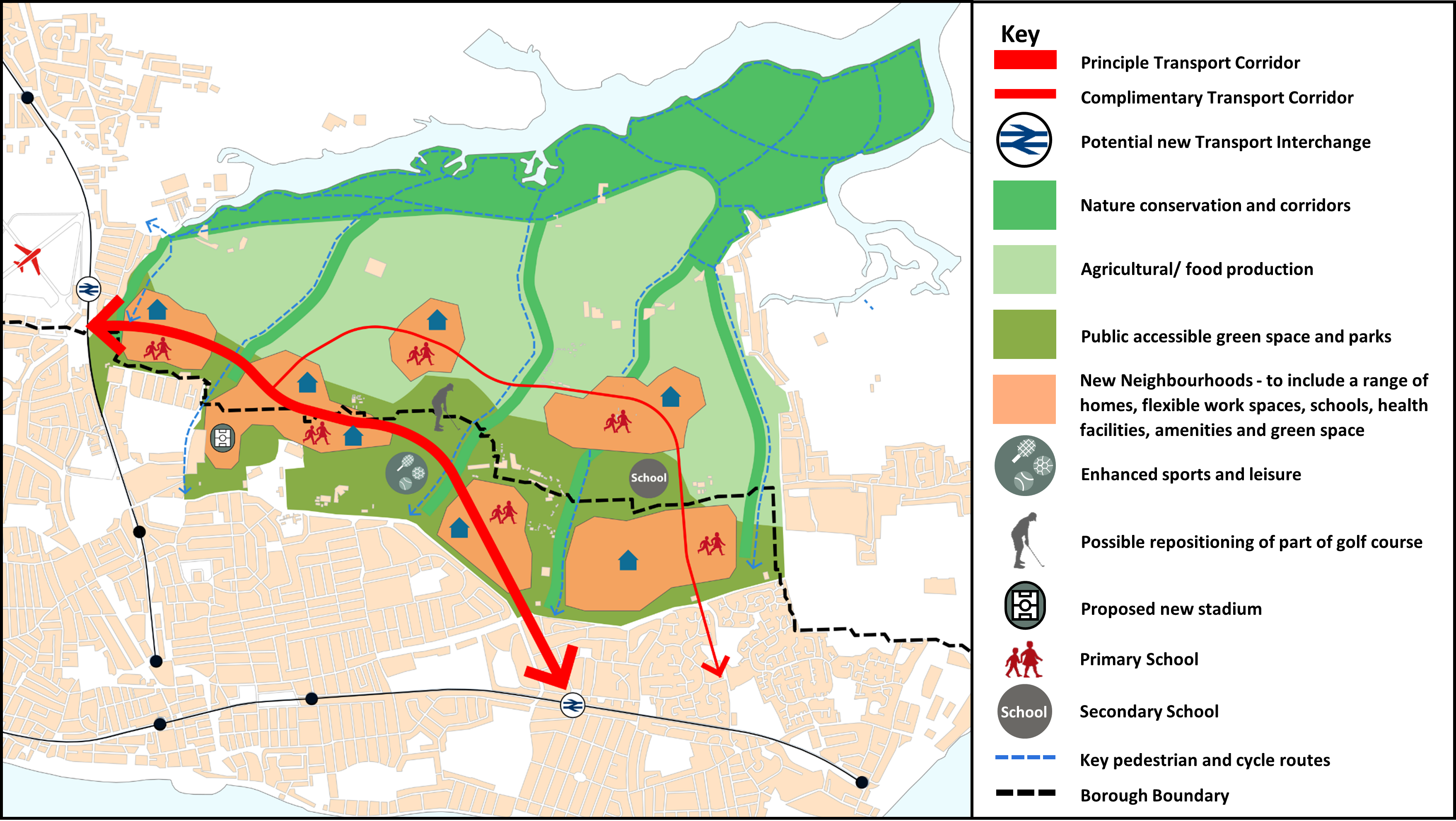
Diagram submitted to the Borough Council as evidence - ‘Potential growth options in Rochford and Southend – Proof of Concept’ (2021) Iceni on behalf of Cogent Land
As part of the wider development area lies outside Southend Borough, it would be for Rochford District Council to consider whether it supports Strategy Option D as a good option to help meet its development needs, as part of the preparation of its own Local Plan, and it may choose a different approach to meeting the areas housing needs.
Rochford and Southend Council’s would need to co-operate effectively to plan and provide for the new neighbourhoods to come forward under this scenario if the more comprehensive development were to be pursued.
A comprehensive new Garden Settlement being developed would help meet the Government’s assessed housing needs for the area over a 20-year period. Without this comprehensive option coming forward, the Borough is unable to fully meet its housing requirements within or on the edge of Southend.
Question 2.3d Providing New Homes: Broad Type of Sites Strategy Option D: series of new neighbourhoods on the edge of Southend
Have your say………
Please explain your answers
a) Do you support the provision of a series of new neighbourhoods on the edge of Southend to create a Garden Settlement (Figure 9) to include new homes and family housing, jobs, a new country park, community services, transport links and supporting infrastructure? Please explain your answer and let us know what your priorities would be if a series of neighbourhoods were to be delivered – what types of supporting facilities, services, green space and infrastructure should be provided?
b) Are there opportunities for the development to successfully integrate with existing communities, town and local centres and the wider transport network? Please explain your answer.