3.1.1 General Character
Eastwood is a suburban predominantly residential area on the north-west fringes of the Borough. It is a relatively modern area of Southend principally featuring post-war buildings. It is defined to the south by the A127 and to the north by open countryside, designated as forming part of the Metropolitan Green Belt (Map 13, Figure 14).
A substantial part of Eastwood is laid out to cul-de-sac style residential development, largely lacking the classic grid structure that defines most of the Borough. The style and format of buildings varies significantly but includes chalet style houses and more substantial properties in the ‘Nobles Green’ area. Eastwood is a relatively low-density part of Southend. The neighbourhood is well served by public open space and has good accessibility to the adjoining Cherry Orchard Way Country Park and Edwards Hall Park.
The main retail focus is a Morrison’s food store based on an out-of-town format at Western Approaches and a Lidl store situated on the junction of Progress Road and Rayleigh Road. Rayleigh Road contains a mix of small commercial uses, shops, restaurants and cafes as well as some community / health facilities, such as pharmacies and doctors’ surgeries. It also provides the main transport corridor and bus route linking the Eastwood Neighbourhood with Southend town centre and Rayleigh. The area is not well served by public transport, with the nearest stations being at Leigh (3 miles away) and Rayleigh (2.5 miles away) in neighbouring Rochford district and with a lack of bus services, namely to Leigh and generally running north/ south. The area contains three important employment areas at Progress Road, Airborne Close and Aviation Way with smaller estates at Comet Way and Laurence Industrial Estate. Key issues for the Eastwood Neighbourhood include realising the full potential of the employment areas north of the A127 to provide for future employment needs.
Map 13: Eastwood Characteristics
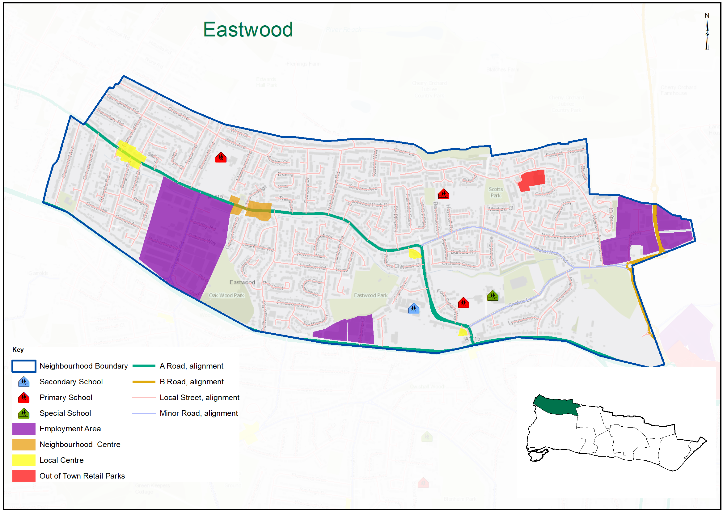
Figure 14: Eastwood Characteristics
|
No. Homes |
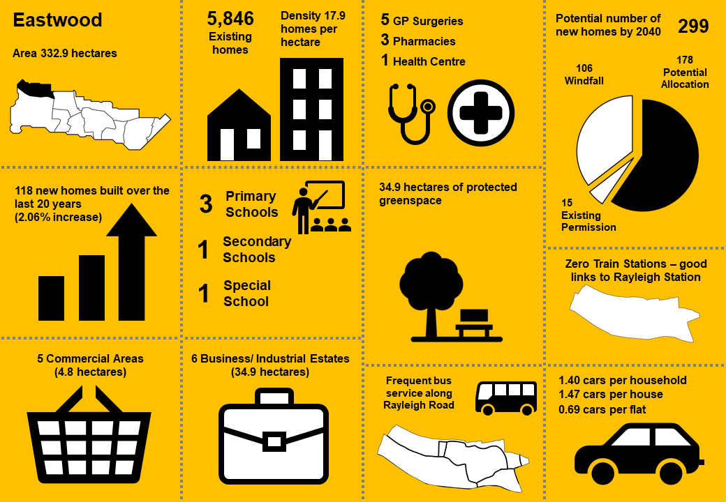
5,846 |
Land Area (ha) |
332.9 |
|
Density |
17.9 dph |
Car Ownership per home |
1.4 |
3.1.2 Vision
Where we want to be
Eastwood will continue to be a suburban area interspersed with mature parkland with improved cycle and pedestrian links within the urban area and to the surrounding countryside. The vibrant Local Centres on the Rayleigh Road and at Western Approaches will continue to serve the local community, with the Rayleigh Road continuing to provide a public transport corridor, well served by buses, connecting the neighbourhood with Southend and Rayleigh town centres. The employment areas aligning the A127 Arterial Road will offer increasing employment opportunities. A draft set of priorities for Eastwood is set out below to aid feedback:
- Sustainable growth of the suburbs with intensification of residential development focused along Rayleigh Road, benefitting from a frequent bus service and access to a range of local shops and services.
- Residential development elsewhere in the neighbourhood mainly by infilling of existing plots and increasing the density of existing development.
- New residential development and conversions will be of a high standard of design, sensitive to the existing residential character.
- Promote the employment growth clusters at the major employment areas of Progress Road, Airborne Close and Aviation Way.
- Promote the smaller employment areas, Comet Way and Laurence Industrial Estate, for retention and renewal.
- Develop new employment land to the west of Nestuda Way to provide a quality offer.
- Development in the Eastwood Brook flood zone will be controlled by planning policies to mitigate flood risk.
- Strengthen walking and cycling connections throughout the area with enhanced routes and wayfinding, including links to the local centres, with improved bus links to Leigh and the Airport Business Park.
- Seek to safeguard existing green space, with access to Cherry Orchard Country Park and Edward Hall Park nature conservation area promoted and enhanced.
- Consider potential for agricultural land and smallholdings west of Nestuda Way to be released to realise strategic transport and housing ambitions.
Question 3.1.2 Eastwood (Vision)
Have your say………Please explain your answers
a. Do you agree with our draft vision and priorities for Eastwood? If not, let us know what we have missed?
3.1.3 Complete Neighbourhoods (accessibility to services and facilities)
The following profile seeks to build up a picture of the ‘completeness’ of Eastwood. Completeness is based on mapping the walking catchments around different day to day facilities (17 different facilities in total)*. The catchment areas vary by facility and reflect comfortable walking distances for the average, able-bodied person. The catchments are based on actual walking routes rather than ‘as the crow flies’ distances.
A high completeness score means a place has lots of facilities the community needs within an easy walking distance. This approach recognises the important links to health and social well-being, community cohesion and inclusion.
The completeness score for Eastwood, by infrastructure type, is summarised in the rainbow image below. For example 74% of the neighbourhood lies within easy walking distance to a health facility and 63% of the neighbourhood is within easy walking distance of sports and leisure facilities, while 23% is within easy walking distance of green space.
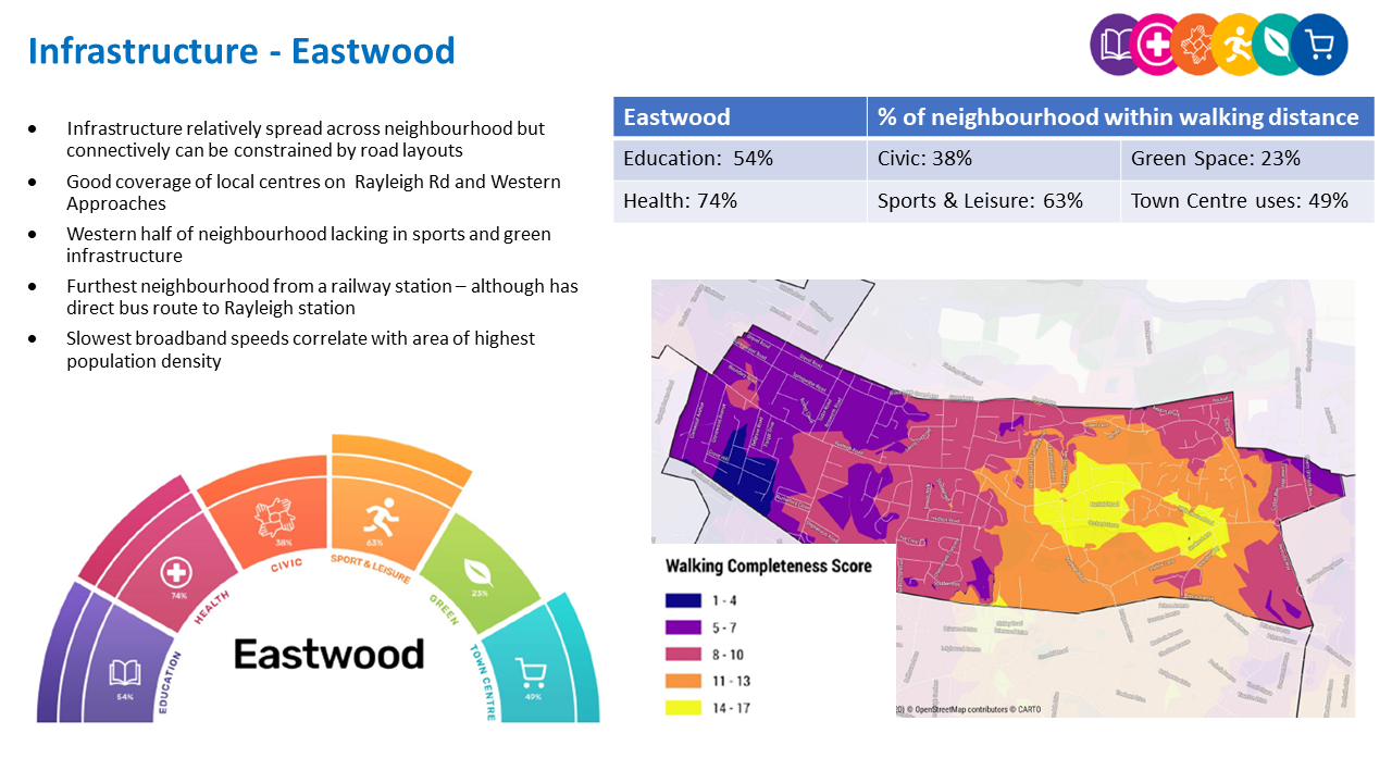
Eastwood ‘Aggregated Completeness Score’ = 50%
Map – as an example a high completeness score would be 14 –17 different facilities being within a reasonable walking distance from home. Conversely a low score would be less than 4 facilities within walking distance.
Question 3.1.3 Eastwood (Infrastructure)
Have your say…….Please explain your answer
a. Are there any issue with infrastructure provision in Eastwood? Please explain your answer and let us know what the priorities should be over the next 20 years.
3.1.4 Land Use Proposals - Eastwood
A number of potential land use proposals are identified for future housing, employment and open space. For each site, the location, proposed use and indicative amount of development (if applicable) is provided.
3.1.4.1 New Homes
The type and quality of the housing offer can have a significant impact on the health and wealth of places. Their ability to attract and retain people and provide support for those who need it relies on good housing and attractive and inclusive neighbourhoods.
Potential site proposals for residential development can be viewed in Map 14. Table 20a sets outs relevant information including, context and surrounding uses, proposed use, estimated number of new dwellings and what ‘components of growth’ the site contributes to in reference to Part 2: Housing Need (Table 2).
The sites have been promoted to us by landowners/ agents and are included here for comment. Table 20a also notes the amount of new homes that are likely to come forward over the lifetime of the plan through sites already with planning permission and windfall development.
For more information on each site an assessment can be viewed by clicking on the link reference in Table 20a below, or via the Councils website: Appendix 4: Site Proformas | Southend Local Plan
Map 14: Potential Residential Sites - Eastwood (excluding those with planning permission)
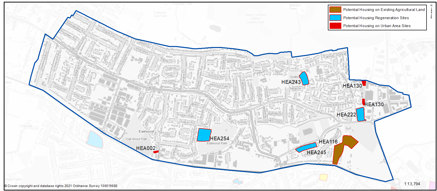
Table 20a: Potential Residential Sites - Eastwood
Individual potential sites listed below
Question 3.1.41a Eastwood (Residential)
HEA002... 112 Bellhouse Road (further details)
HEA002
Context/ Surrounding Uses - The site primarily consists of a single residential dwelling house located on a rectangular plot on the west side of Bellhouse Road, Eastwood. The site is also in close proximity to the A127 and Oakwood Park.
Potential Land Use - Small site with potential for 5 dwellings (net).
Potential Land Use Summary - Residential development
Component Change - Urban Area General
| https://localplan.southend.gov.uk/sites/localplan.southend/files/2021-08/Eastwood%20Proformas.pdf#page=3 |
Question - 3.1.41a. Do you agree with the potential proposals for this site? Please explain your answer. You may wish to outline the type and scale of development you would like to see come forward in reference to Figure 15: Development Typologies
Question 3.1.41a Eastwood (Residential)
HEA130...Vacant land to north and south of Lundy Close (further details)
HEA130
Context/ Surrounding Uses - Site includes two parcels of land either end of an area of green space (not designated) associated with the adjacent housing estate. Surrounding uses are mixed including housing and employment to the north and east (Comet Way Employment Area).
Potential Land Use - The site is Council owned and considered potentially available for future residential redevelopment.
Potential Land Use Summary - Residential development
Component Change - Urban Area General
Estimated Number of Homes gross 7 - Net 7
| https://localplan.southend.gov.uk/sites/localplan.southend/files/2021-08/Eastwood%20Proformas.pdf#page=5 |
Question 3.1.41a Do you agree with the potential proposals for this site? Please explain your answer. You may wish to outline the type and scale of development you would like to see come forward in reference
Question 3.1.41a Eastwood (Residential)
HEA222... Bishop House, Western Approaches (further details)
HEA222
Context/ Surrounding Uses - Predominantly 2 storey building currently in use as sheltered housing located in an existing residential area. Commercial uses to the east. Sports/recreation uses to the south. The site is in close proximity to the Airport.
Potential Land Use - Existing building in public ownership that may benefit from some renewal, redevelopment or expansion that could provide new and better quality homes that are designed to be adaptable so local people can reside independently through all stages of their lives. To gain a comprehensive understanding of development potential, all existing housing estates in public ownership have been included for comment. At the time of publication of this document no Council decision has been made on redeveloping this site.
Potential Land Use Summary - Residential development
Component Change - Housing Regeneration Sites
Estimated Number of Homes gross 74 - Net 16
| https://localplan.southend.gov.uk/sites/localplan.southend/files/2021-08/Eastwood%20Proformas.pdf#page=6 |
Question 3.1.41a Do you agree with the potential proposals for this site? Please explain your answer. You may wish to outline the type and scale of development you would like to see come forward in reference to Figure 15: Development Typologies
Question 3.1.41a Eastwood (Residential)
HEA243... Scott House, 171 Neil Armstrong Way (further details)
HEA243
Context/ Surrounding Uses - Group of buildings, 1 to 3 storeys, in use as sheltered accommodation. Located in a low-rise residential area. The site is bounded by Scott Park to the west with a community centre and Morrisons supermarket to the east.
Potential Land Use - Existing building in public ownership that may benefit from some renewal, redevelopment or expansion that could provide new and better quality homes that are designed to be adaptable so local people can reside independently through all stages of their lives. To gain a comprehensive understanding of development potential, all existing housing estates in public ownership have been included for comment. At the time of publication of this document no Council decision has been made on redeveloping this site.
Potential Land Use Summary - Residential development
Component Change - Housing Regeneration Sites
Estimated Number of Homes gross 74 - Net 16
| https://localplan.southend.gov.uk/sites/localplan.southend/files/2021-08/Eastwood%20Proformas.pdf#page=7 |
Question 3.1.41a Do you agree with the potential proposals for this site? Please explain your answer. You may wish to outline the type and scale of development you would like to see come forward in reference to Figure 15: Development Typologies
Question 3.1.41a Eastwood (Residential)
HEA245... 68-114 Snakes Lane (further details)
HEA245
Context/ Surrounding Uses - 2 storey blocks of flats with landscapes areas fronting Snakes Lane. Large areas of landscaped areas to the rear of the properties. To the south of the site are residential uses with the A127 beyond.
Potential Land Use - Existing building in public ownership that may benefit from some renewal, redevelopment or expansion that could provide new and better quality homes that are designed to be adaptable so local people can reside independently through all stages of their lives. To gain a comprehensive understanding of development potential, all existing housing estates in public ownership have been included for comment. At the time of publication of this document no Council decision has been made on redeveloping this site.
Potential Land Use Summary - Residential development
Component Change - Housing Regeneration Sites
Estimated Number of Homes gross 82 - Net 34
| https://localplan.southend.gov.uk/sites/localplan.southend/files/2021-08/Eastwood%20Proformas.pdf#page=8 |
Question 3.1.41a Do you agree with the potential proposals for this site? Please explain your answer. You may wish to outline the type and scale of development you would like to see come forward in reference to Figure 15: Development Typologies
Question 3.1.41a Eastwood (Residential)
HEA254... Beaver Tower (further details)
HEA254
Context/ Surrounding Uses - Residential estate comprising 2 storey terraced properties, garages, and a 12 storey tower. The site is bounded by Eastwood Park in a residential area.
Potential Land Use - Existing building in public ownership that may benefit from some renewal, redevelopment or expansion that could provide new and better quality homes that are designed to be adaptable so local people can reside independently through all stages of their lives. To gain a comprehensive understanding of development potential, all existing housing estates in public ownership have been included for comment. At the time of publication of this document no Council decision has been made on redeveloping this site.
Potential Land Use Summary - Residential development
Component Change - Housing Regeneration Sites
Estimated Number of Homes gross 136 - Net 40
| https://localplan.southend.gov.uk/sites/localplan.southend/files/2021-08/Eastwood%20Proformas.pdf#page=9 |
Question 3.1.41a Do you agree with the potential proposals for this site? Please explain your answer. You may wish to outline the type and scale of development you would like to see come forward in reference to Figure 15: Development Typologies
Question 3.1.41a Eastwood (Residential)
HEA116... Land at Brendon Way/North of Prince Avenue (further details)
HEA116
Context/ Surrounding Uses - Agricultural land within the built up area of Southend, a field and a western section of an adjoining larger field. Hedgerow runs north-south across the site. The site is bounded by Prince Avenue (A127) and to the north by sport facilities. Residential properties lie to the west.
Employment land to the north surrounding Cherry Orchard Way. Southend Airport is to the north east. Development of the site would need to consider access arrangements, proximity of runway and loss of agricultural land.
Potential Land Use - This Council owned site has been submitted through the Call for Sites process for residential development.
Potential Land Use Summary - Residential development
Component Change - Agricultural Land
Estimated Number of Homes - gross 60 - Net 60
| https://localplan.southend.gov.uk/sites/localplan.southend/files/2021-08/Eastwood%20Proformas.pdf#page=4 |
Question 3.1.41a Do you agree with the potential proposals for this site? Please explain your answer. You may wish to outline the type and scale of development you would like to see come forward in reference to Figure 15: Development Typologies
Question 3.1.41b Eastwood (Residential)
Have your say………
Please provide comment in support of your choice
b.Do you have any other comments on housing provision in Eastwood?
3.1.4.2 Urban Form and Development Typologies
Good quality urban design will be essential in new housing development if the character of the neighbourhood is to be enhanced.
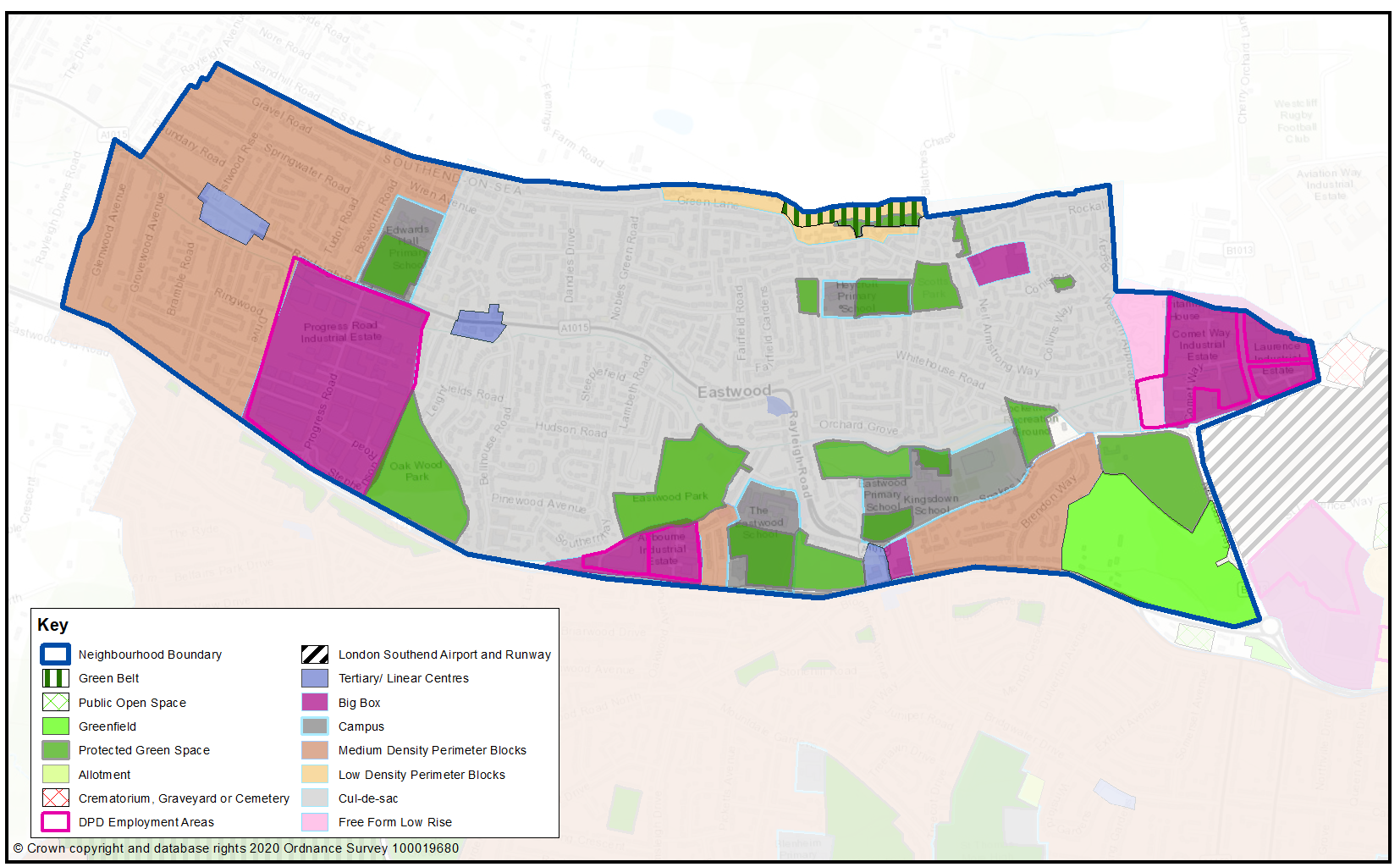
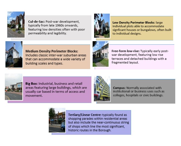
Map 15 shows the Urban Forms of Eastwood neighbourhood. This has been informed by the Southend Borough Wide Character Study3 and is intended to provide a broad overview of the types and densities of development across the neighbourhood; this can range from low density, areas of detached housing, to high rise flats.
To assist with the preparation of development management and design policies, which will impact the scale, type and density of new homes, we are interested in your views on broadly what types of development you think should come forward in the neighbourhood. It may be that there are different parts of the neighbourhood that you think could accommodate different types of development.
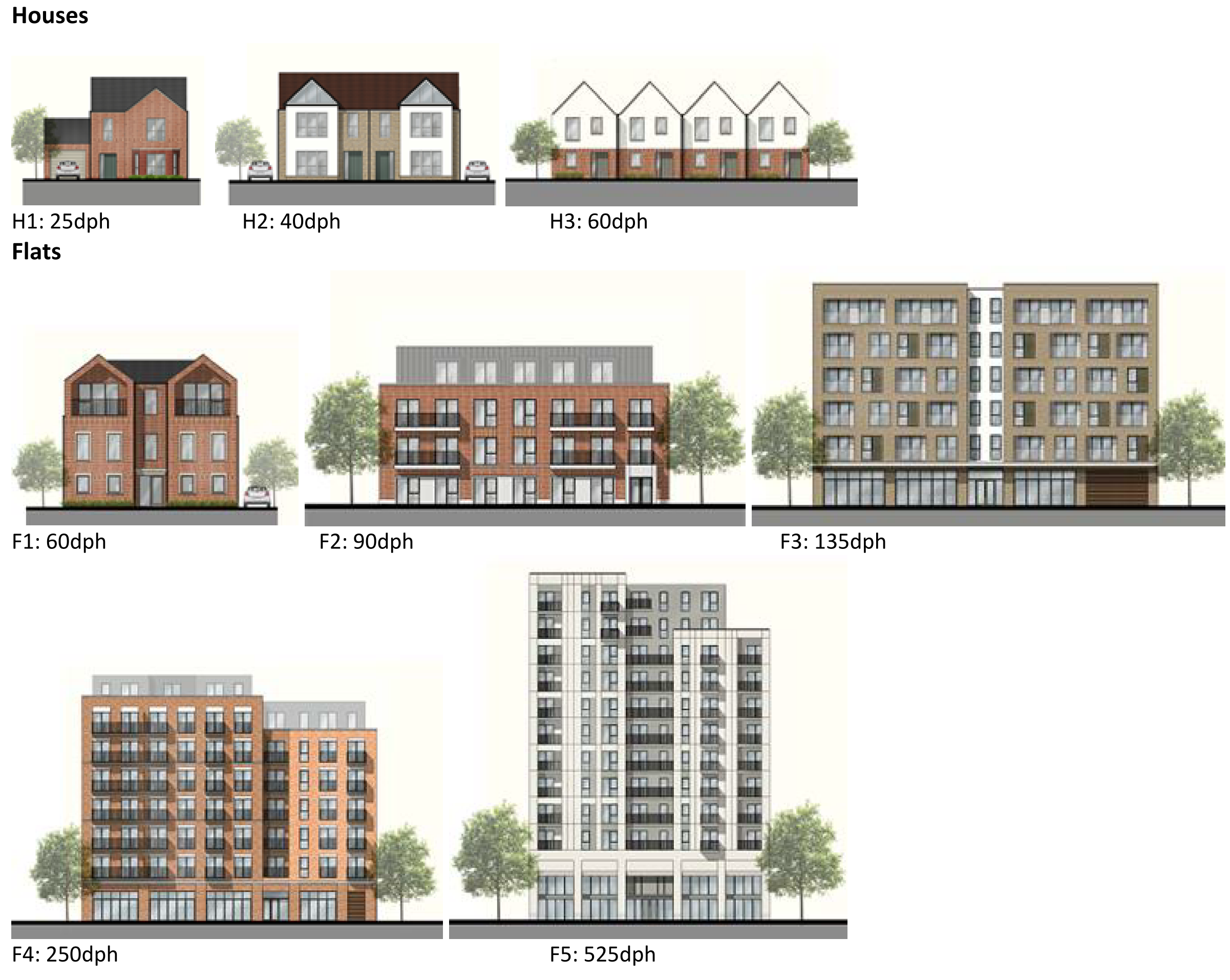
Figure 15 provides a range of development typologies at different densities, for both houses and flats. We’d like to know whether there is a particular typology that you’d like to see come forward in Eastwood and within the different Urbans Forms as shown in Map 15. For instance you may believe the ‘Secondary Centre’ areas within Map 15 should accommodate the highest density development, such as flats typology F2 and F3, within Figure 15.
Figure 15 - Development Typologies
Map 15: Eastwood Urban Forms
Question 3.1.42 Eastwood (Urban Forms)
Have your say………
Please provide comment in support of your choice
a. What types of development typology (Figure 15) do you think should come in Eastwood? You may wish to refer to the different urban forms presented in Map 15 in your answer.
To view our mapping feature showing Urban Forms: Southend-on-Sea Borough Council – Local Plan: Map 2 Urban Forms Map (opus4.co.uk)
3.1.4.3 Employment
The retention and provision of employment sites is necessary to enable balanced job and housing growth. However, employment land has relatively lower land values compared to residential and therefore it is important to safeguard or allocate sites to facilitate present and future economic growth. In the Eastwood Neighbourhood it is proposed to safeguard the existing employment areas (promoting the employment growth clusters in the major employment areas at Progress Road, Airborne Close and Aviation Way, and promoting the smaller employment areas of Comet Way and Laurence Industrial Estate for retention and renewal), and to allocate a new employment area at Nestuda Way to provide a quality offer (Map 16, Table 21).
Map 16: Eastwood Employment Areas
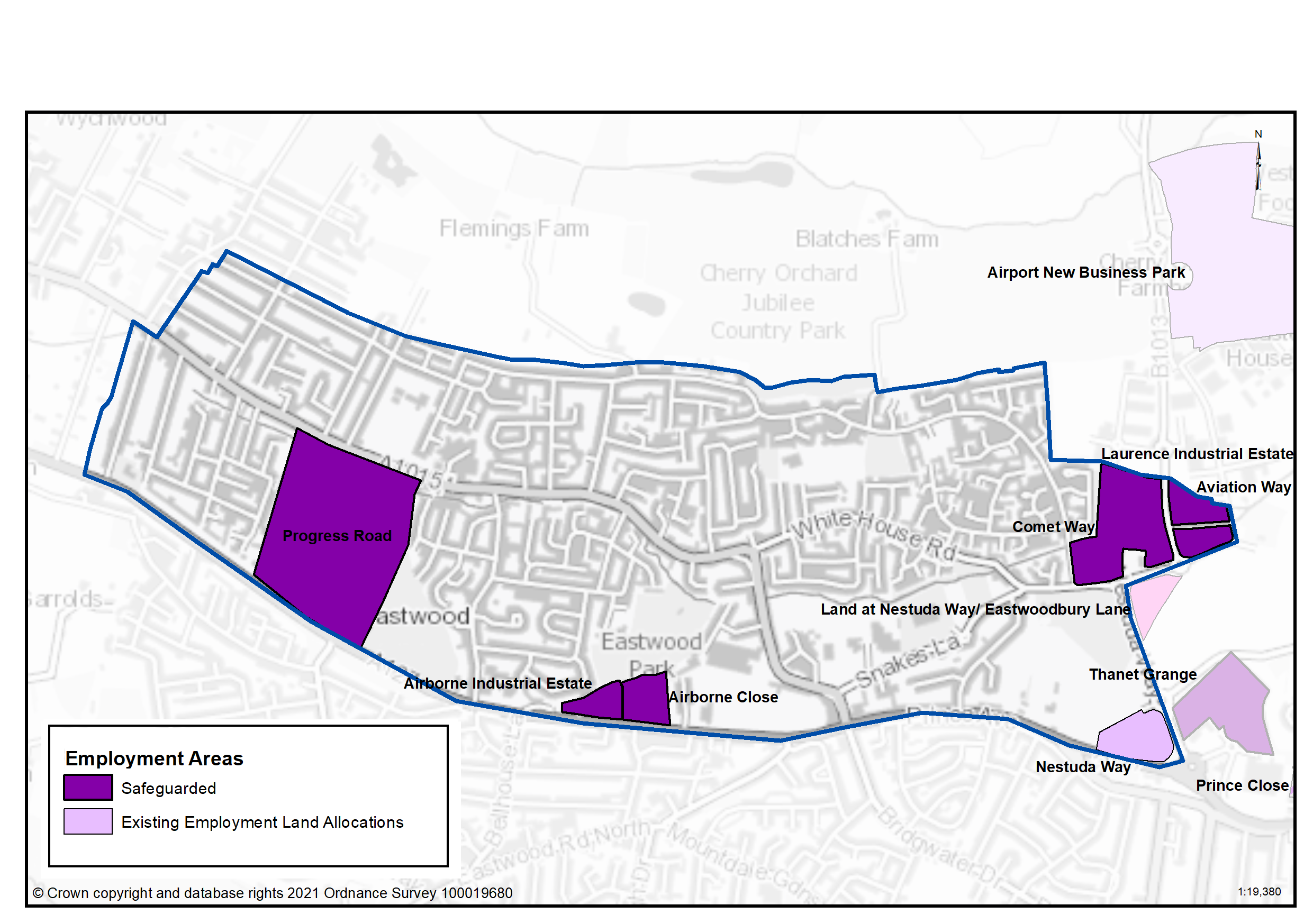
Table 21: Land Use Proposals in Eastwood – Employment Land
|
Site Name (ref) |
Category |
Hectares |
Additional Floorspace |
|
Progress Road (EA033) |
Growth |
21.46 |
6,200 |
|
Airborne Close |
Renewal |
2.02 |
|
|
Airborne Industrial Estate |
Renewal |
1.39 |
|
|
Aviation Way |
Renewal |
1.59 |
|
|
Nestuda Way (EA023) |
New Allocation |
2.75 |
10,000 |
|
Comet Way |
Renewal |
7.16 |
|
|
Laurence Industrial Estate |
Renewal |
1.26 |
|
| Total | 37.63 | 16,200 |
Question 3.1.4.3a Eastwood (Employment)
Have your say………
Please explain your answers
a. Do you agree that Progress Road should be safeguarded as an employment growth site?
a. Do you agree that Airbourne Close should be safeguarded as an employment renewal site?
a. Do you agree that Airbourne Industrial Estate should be safeguarded as an employment renewal site?
a. Do you agree that Aviation Way should be safeguarded as an employment renewal site?
a. Do you agree with this proposed employment new allocation site for Nestuda Way?
a. Do you agree that Comet Way should be safeguarded as an employment renewal site?
a. Do you agree that Laurence Industrial Estate should be safeguarded as an employment renewal site?
Question 3.1.4.3b Eastwood (Employment)
b. Do you have any other comments on employment land provision in Eastwood? If yes, please explain your answer.
3.1.44 Commercial Centres
To ensure the vitality of town centres, the National Planning Policy Framework encourages local planning authorities to implement planning policies and decisions that support the role that town centres play at the heart of local communities, by taking a positive approach to their growth, management, and adaptation.
The Government recently introduced changes to the Use Classes Order which consolidates a wide range of uses including retail, food, financial services, gyms, healthcare, nurseries, offices, and light industry into a single use class (Use Class E) and any change of use of a building or land between those uses falling within this Use Class will not require planning permission. It is therefore proposed to define as “Commercial Areas”, centres where we will promote ground floor uses to be within Class E Use Class and encourage improvements to shopfronts and the street scene.
There are a range of commercial centres in the Borough that protect ground floor uses for business purposes (use class E4) and thereby perform a vital function by ensuring communities are served by a range of retail and commercial services. Eastwood’s commercial centres are set out in Map 17 and Table 22.
As of August 2021, the Government is also introducing expanded permitted development rights to enable Commercial Uses to be converted to residential without planning permission. Due to this there are limitations on safeguarding ground floor commercial uses within key centres from changing to residential. However, under Article 4 of the General Permitted Development Order a local planning authority can apply to the Secretary of State to withdraw specified permitted development rights across a defined area. The use of Article 4 directions should not be expansive and therefore if we were to use them to restrict ground floor commercial uses from changing to residential, we must focus them to the most important frontages. In reference to Map 17 and Table 22 we are interested in your views on which centres we should investigate for using Article 4 Directions in order to restrict ground floor commercial frontages from being developed to residential under permitted development.
Map 17: Eastwood Commercial Centres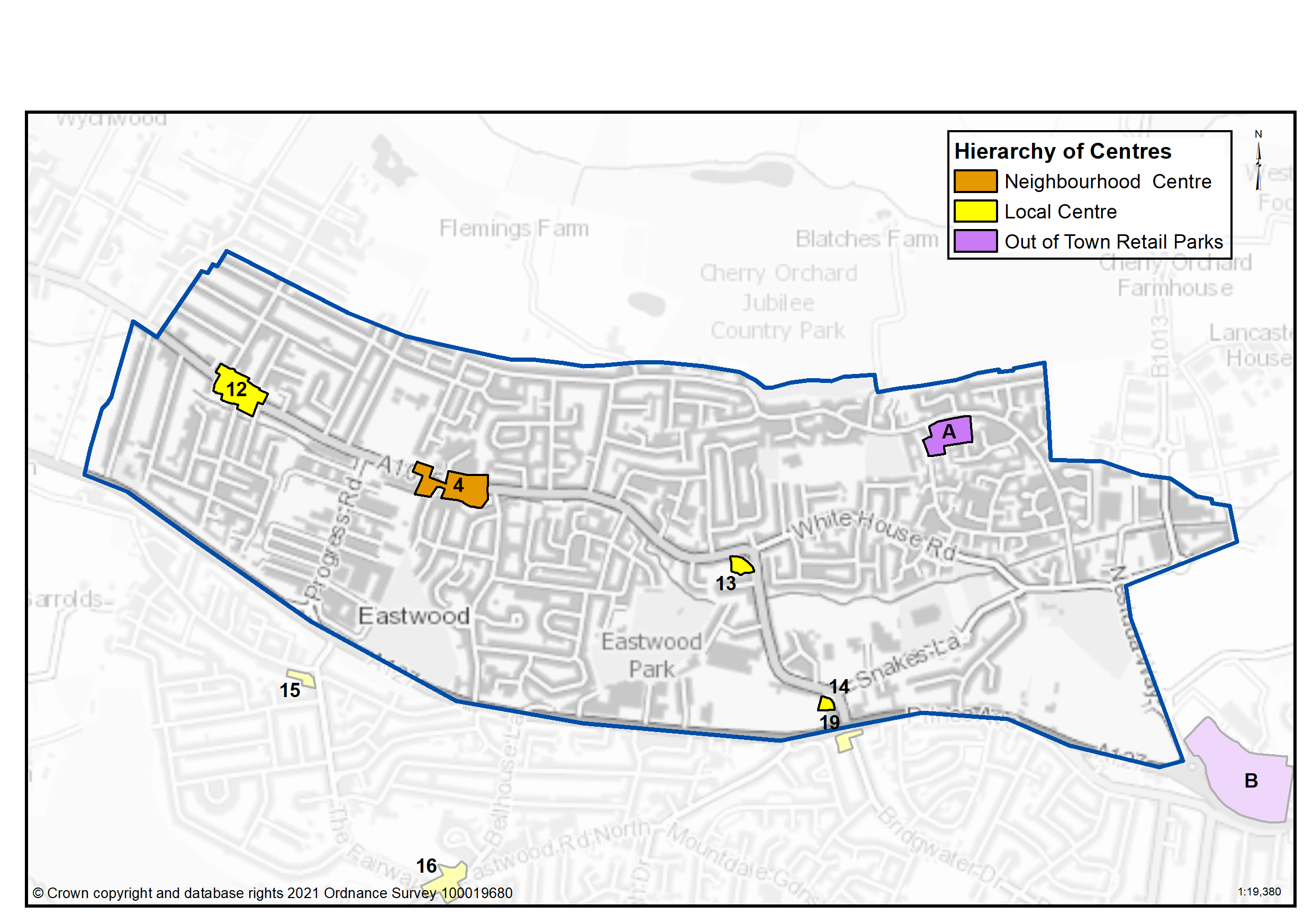
Table 22: Eastwood Commercial Centres
|
Ref |
Name |
Centre Type |
|---|---|---|
|
4 |
Eastwood (Rayleigh Road) |
Neighbourhood Centre |
|
12 |
Rayleigh Road, (The Oakwood PH) |
Local Centre |
|
13 |
Rayleigh Road / Whitehouse Road |
Local Centre |
|
14 |
Rayleigh Road, Kent Elms Corner |
Local Centre |
|
A |
Eastwood (Western Approaches) |
Out of Town Retail Parks |
Question 3.1.4.4a Eastwood (Commercial Centres)
Have your say…….Please explain your answer
a. Should we define Eastwood (Rayleigh Road) as a Neighbourhood Centre as set out in Table 22 and Map 17 to promote a range of commercial uses to serve local community needs and provide local employment opportunities?
a. Should we define Rayleigh Road (The Oakwood PH) as a Local Centre as set out in Table 22 and Map 17 to promote a range of commercial uses to serve local community needs and provide local employment opportunities?
a. Should we define Rayleigh Road/Whitehouse Road as a Local Centre as set out in Table 22 and Map 17 to promote a range of commercial uses to serve local community needs and provide local employment opportunities?
a. Should we define Rayleigh Road/Kent Elms Corner as a Local Centre as set out in Table 22 and Map 17 to promote a range of commercial uses to serve local community needs and provide local employment opportunities?
a. Should we define Eastwood (Western Approaches) as an Out of Town Retail Park as set out in Table 22 and Map 17 to promote a range of commercial uses to serve local community needs and provide local employment opportunities?
Question 3.1.4.4b Eastwood (Commercial Centres)
Have your say…….Please explain your answer
b. Should we investigate using Article 4 direction to safeguard ground floor commercial uses within the town, district and neighbourhood centres by restricting permitted development changes to residential – if yes what frontages?
Question 3.1.4.4c Eastwood (Commercial Centres)
Have your say…….Please explain your answer
c. Are there any other areas within the Eastwood Neighbourhood area that we haven’t identified that should be promoted for commercial activities? If yes, please let us know where.
3.1.4.5 Green Space - Eastwood
National planning policy allows for Local Plans to identify and protect existing green space so it is not built on unless an assessment demonstrates the open space, buildings or land are surplus to requirements; any open space lost would be replaced by equivalent or better provision in terms of quantity, quality and access; or the benefits of new sports and recreation facilities clearly outweigh the loss of the current or former use as open space. In this respect the New Local Plan seeks to protect the green spaces as set out in Table 23 and Map 18.
Existing Green Space
Eastwood is well provided for with green space, with a number of medium sized parks distributed relatively evenly throughout the neighbourhood. Although a small area of the neighbourhood to the north-west falls outside the catchment of the existing local parks, Edwards Hall Park nature conservation area and Cherry Orchard Way Country Park lie just to the north within Rochford District, and are accessible on foot or bicycle for residents. Tree Canopy cover within Eastwood is broadly average for the Borough at 10% in St Laurence Ward and 12% in Eastwood Park, against a target in the Council’s Tree Policy to extend the overall tree canopy cover in the Borough from 12% to 15% by 2050.
Local Green Space
National planning policy allows local authorities to designate land as Local Green Space through their local plans, so that communities can identify and protect green areas of particular importance to them, for example because of its historic significance, recreational value, tranquillity, beauty or richness of its wildlife. Policies for managing Local Green Space are consistent with those for Green Belts.
Proposed ‘Local Green Space’ - Eastwood Park has a range of facilities including multi use games area, gym equipment, skate-park, children’s playground, formal gardens and parkland. Oakwood Park provides a tranquil space for recreation bordered by woodland and providing a buffer between A127 and residential properties to the north and east. For these reasons the open spaces are special to the communities they serve, and are in close proximity to them. The outcome of this consultation will be particularly important in demonstrating that these spaces are special to the community (Table 23).
New Green Space
An amenity space at Brookfields is good quality with mature trees and is not currently protected. It is therefore proposed that it is designated as a new green space (Table 23a).
Map 18: Green Space in Eastwood
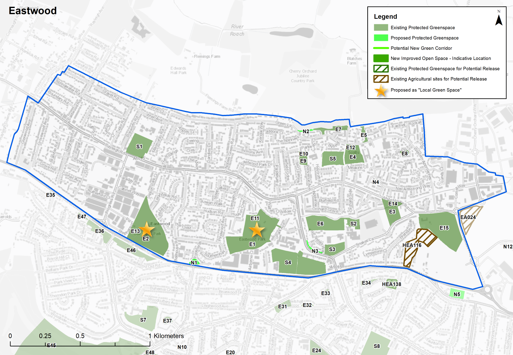
Table 23: Eastwood - Protected Green Space
|
Site Ref. |
Name of Site |
Size (Ha) |
|
Site Ref. |
Name of Site |
Size (Ha) |
|---|---|---|---|---|---|---|
Local Park |
Playground |
|||||
|
E1 |
Eastwood Park |
6.093 |
E10 |
Benvenue Avenue - Dandies Park Childrens Play Area |
0.046 |
|
|
E2 |
Oakwood Park |
6.160 |
E11 |
Eastwood Park playground |
0.163 |
|
|
E3 |
Cockethurst Park |
1.445 |
E12 |
Scotts Park playground |
0.205 |
|
|
E4 |
Scotts Park |
1.338 |
E13 |
Oakwood Park playground |
0.063 |
|
Amenity Open Space |
E14 |
Cockethurst playground |
0.092 |
|||
|
E5 |
Repton Green Open Space |
0.280 |
Sports Ground |
|||
|
E6 |
Four Sisters Way Open Space |
2.445 |
E15 |
Eastwoodbury Lane Playing Fields |
5.231 |
|
|
E7 |
Green Lane Open Space |
0.584 |
School |
|||
|
E8 |
Coniston Open Space |
0.177 |
S1 |
Edwards Hall Primary |
2.066 |
|
|
E9 |
Benvenue Avenue - Dandies Park |
0.495 |
S2 |
Kingsdown School |
0.594 |
|
|
|
S3 |
Eastwood Junior School |
1.005 |
|||
|
S4 |
Eastwood School |
4.894 |
||||
|
S5 |
Heycroft School |
1.486 |
||||
Sites in Bold are proposed as ‘Local Green Space’
Note: Edwards Hall Park lies within Rochford District but is accessed via a path within Eastwood and is therefore used frequently by Southend residents.
Table 23a: Eastwood – Proposed Green Space Allocations
Question 3.1.45a. Eastwood – Proposed Green Space Allocations
N1... Brookfields Open Space
Amenity Open Space
Site Ref - N1
Name of Site - Brookfields Open Space
Size (Ha) - 0.211
Question 3.1.45a. Do you support the proposed new green space designation at Brookfields?
N2... Green Lane Open Space Extention
Amenity Open Space
Site Ref - N2
Name of Site - Green Lane Open Space Extention
Size (Ha) - 0.108
Question 3.1.45a. Do you support the proposed new green space designation at Green Lane?
N3... Four Sisters Close / Rayleigh Road - Details
Amenity Open Space
Site Ref - N3
Name of Site - Four Sisters Close / Rayleigh Road
Size (Ha) - 0.147
Question 3.1.45a. Do you support the proposed new green space designation at Four Sisters Close/Rayleigh Road?
N4... Neil Armstrong Way
Pocket Park
Site Ref - N4
Name of Site - Neil Armstrong Way
Size (Ha) - 0.022
Question 3.1.45a. Do you support the proposed new green space designation at Neil Armstrong Way?
HE116... Land at Brendon Way/North of Prince Close
Table 24: Land Use Proposals in Eastwood – Green Space Currently Protected but with potential for release
HEA116
Context/ Surrounding Uses - One field and part of a second field split by a hedgerow, to south of Len Forge Centre. Surrounding area predominantly residential but adjacent to A127, and close to Airport runway.
Quality/ Condition - Southern section is high grade agricultural land.
Area of Deficiency - N
Site Area (ha) - 2.45
Potential Capacity - Net 60
Justification - Land is in public ownership and underutilised, with potential for residential development.
Question 3.1.45b Do you have any comments on the green space site identified as having potential to be released for development at Brendon Way/North of Prince Close?
E1 Eastwood Park
Local Park
Site Ref - E1
Name of Site - Eastwood Park
Size (Ha) - 6.093
3.3.45c. Do you agree with Eastwood Park being proposed as Local Green Space (Map 18, Table 23)? If not, can you explain your reasons?
E2 - Oakwood Park
Local Park
Site Ref - E2
Name of Site - Oakwood Park
Size (Ha) - 6.160
3.3.45c. Do you agree with Oakwood Park being proposed as Local Green Space (Map 18 Table 23)? If not, can you explain your reasons?
3.1.4.5d Eastwood (Green Space)
Have your say………Please explain your answer
d. Are there any other green spaces that you think should be designated as Local Green Space? If yes, please provide an address and supporting evidence that outlines how the space is special to the local community in terms of beauty, historic significance, recreational value, tranquillity, wildlife or for other reasons.
3.1.4.5e Eastwood (Green Space)
Have your say………Please explain your answer
e. Do you have any other comments regarding green space in Eastwood? If yes, please explain your answer.
*nurseries, primary schools, secondary schools, doctors, dentists, pharmacies, libraries, places of worship, public conveniences, community centres and halls, playing pitches, local equipped play space, amenity greenspace, allotments, natural and semi-natural greenspace, local and neighbourhood centres, town and district centres.