3.2.1 General Character
Leigh is defined at its northern edge by the A127, which abuts Eastwood, and by the Thames Estuary to the south. To the west is the Borough boundary with Castle Point, and the Westcliff and Prittlewell neighbourhoods lie to the east (Map 19, Figure 16). Leigh is a large area and therefore to aid analysis and insight the New Local Plan has considered it in terms of two sub-areas, Leigh (south) and Leigh (north).
Leigh (south) – The southern part of the Leigh (south) neighbourhood is focussed on a vibrant district shopping centre centred around the Broadway and Leigh Road on the hilltop overlooking the Leigh Old Town. Extending out from this core are residential areas largely built out in the Edwardian and Inter war period. This includes more tightly planned, often terraced housing close to Leigh district centre, with more semi-detached/detached housing to the west (Marine Estate), north (Highlands Estate) and to the east (Chalkwell Hall Estate). There are two mainline railway stations in the Leigh (south) Neighbourhood, Leigh-on-Sea to the west and Chalkwell to the eastern edge of the neighbourhood. One of the main issues affecting parts of Leigh, particularly the more tightly planned terraced streets around the heart of the district centre in Leigh (south), is pressure for on-street parking with many of the residential properties not having off-street parking facilities. This is compounded by added car parking pressures by visitors to Leigh district centre.
As well as the estuary, Chalkwell Park provides one of the main areas of open space in Leigh (south), and is enjoyed by residents from adjoining neighbourhoods and beyond. It is complemented by smaller areas of green space, including Leigh Library Gardens and Bonchurch Park, as well as the green space at Belton Way and Marine Parade, and at Leigh Marshes. There is access from the west of the neighbourhood to Two Tree Island nature reserve and through to Hadleigh Castle Country Park.
Leigh Old Town comprises a mix of traditional fishing and boat building industries and several bars, restaurants and cafes as well as beach and other leisure uses associated with the estuary. Leigh Town Council has produced a Spatial Plan for Old Leigh Port and Two Tree Island* which sets out a vision for Old Leigh as a working port town, recognising that establishing a sustainable future for commercial activities, alongside cultural, community and residential uses is vital to the long term character of the place; this has informed the vision for Leigh Old Town within the New Local Plan. Leigh Old Town is one of four Conservation Areas in Leigh. Leigh Old Town, Chapmanslord, Leigh and Leigh Cliff Conservation Areas are all located in the Leigh (south) neighbourhood and make a positive contribution to the sense of place and provide important links with the past, and the historic development of Leigh.
The London Road (A13) forms a spine through Leigh, providing a linear corridor for shops and services, with a greater prevalence of flats along its length. It is also the main focus for bus services and is accessible to many residents in both Leigh (south) and Leigh (north). Prittle Brook Greenway provides a well-used pedestrian and cycle route through the Leigh neighbourhood, linking to Belfairs Park and Woods in the west and through to Southend in the east.
Leigh (north) directly to the north of Leigh (south) is bordered by Eastwood to the north, the boundary formed by the A127. Belfairs Wood, Park and Nature Reserve form an important area of green space in the neighbourhood and provide a range of leisure activities including golf, horse riding and bowls, together with Belfairs Sports Ground, Blenheim Park to the centre of the neighbourhood and a number of other smaller green spaces. A large area of allotments can also be found to the south of the neighbourhood at Manchester Drive.
Leigh (north) does not have a dominant residential type, with a mix of terraced, semi-detached housing and bungalows, and some areas of housing estates in public ownership. The average population density in Leigh (north) is low, which partly reflects the mixed built form and presence of schools and parks, which occupy large areas of land in the neighbourhood.
Access to shops and services by foot is more limited than in Leigh (south), and it is partly dependent on facilities in nearby neighbourhoods and those provided in local centres. London Road and Leigh District Centre are accessible by foot/bike, particularly from the southern extent of Leigh North, and the A13 London Road is also nearby. North-south connections by public transport are also limited however. Blenheim Chase/Kenilworth Gardens provide an important, well-used east-west connection through the neighbourhood, with a number of schools to the eastern edge of the neighbourhood including Blenheim Primary School, St Thomas More High School and the Westcliff Girls and Boys Grammar Schools.
Map 19: Leigh Characteristics
Figure 16: Leigh Characteristics
|
No. Homes |
21,396 |
Land Area (ha) |
1016.6 |
|
Density |
21.04 dph |
Car Ownership |
1.18 |
3.2.2 Vision - Leigh
Where we want to be
Leigh will continue to be a vibrant residential area with a successful commercial centre, complemented by local provision across the neighbourhood. The A13 London Road will remain an important public transport corridor, well served by buses, connecting the neighbourhood with Southend to the east and neighbouring towns to the west, and access enhanced between the north and south neighbourhoods wherever feasible to ensure residents in the north can readily access the services provided in the south of the neighbourhood; this will be complemented by the two mainline railway stations, Leigh-on-Sea and Chalkwell. Old Leigh will maintain its important function as a working port and leisure destination, ensuring these functions carry on in a sustainable manner, balanced with the conservation of the protected estuary environment and Conservation Area. A draft set of priorities for Leigh is set out below to aid feedback:
- Leigh will continue to be a vibrant residential area with a successful commercial centre (Leigh District Centre), extended to encompass Leigh Road, and complemented by local provision in the north and south of the neighbourhood, including at A13 (London Road), and a focus for creative and cultural industries.
- The A13 London Road will be a focus for sustainable growth, mainly through densification in a form that is well designed and respects existing residential character along this sustainable corridor, with residents benefitting from good design and access to a range of shops and services.
- Elsewhere in the neighbourhood new development and conversions will be sensitive to existing character and function of the place, where this doesn’t put additional pressure on the function and sustainability of an area, such as putting pressure on on-street parking.
- Old Leigh will maintain its important function as a working port, residential area, and leisure destination, ensuring these functions carry on in a sustainable manner, balanced with the conservation of the protected estuary environment and heritage assets focussed on the Conservation Area.
- Strengthen walking and cycling connections throughout the neighbourhood with enhanced routes and wayfinding, including links to the railway network, district and local centres. The Cinder Path will be promoted as an enhanced walking and cycling route.
- The character and appearance of the four Conservation Areas (Leigh Old Town, Chapmanslord, Leigh and Leigh Cliff) will be conserved and enhanced;
- Residents and visitors will continue to benefit from a range of open spaces within easy reach.
Question 3.2.2 Leigh (Vision)
Have your say………
Please explain your answers
a. Do you agree with our draft vision and priorities for Leigh? If not, let us know what we have missed.
3.2.3 Complete Neighbourhoods (accessibility to services and facilities)
The following profile seeks to build up a picture of the ‘completeness’ of Leigh. Completeness is based on mapping the walking catchments around different day to day facilities (17 different facilities in total)**. The catchment areas vary by facility and reflect comfortable walking distances for the average, able- bodied person. The catchments are based on actual walking routes rather than ‘as the crow flies’ distances.
A high completeness score means a place has lots of facilities the community needs within an easy walking distance. This approach recognises the important links to health and social well-being, community cohesion and inclusion.
The completeness score for Leigh, by infrastructure type, is summarised in the rainbow image below. For example 80% of the neighbourhood lies within easy walking distance to a health facility, 69% of the neighbourhood is within easy walking distance of sports and leisure facilities, while 24% is within an easy walk of green space.
Leigh ‘Aggregated Completeness Score’ = 57
Map – as an example a high completeness score would be 14 –17 different facilities being within a reasonable walking distance from home. Conversely a low score would be less than 4 facilities within walking distance.
Question 3.2.3 Leigh Infrastructure
Have your say…….
Please explain your answer
a. Are there any issues with infrastructure provision in Leigh? Please explain your answer and let us know what the priorities should be over the next 20 years.
3.2.4 Land Use Proposals - Leigh
A number of potential land use proposals are identified for future housing, employment and open space. For each site, the location, proposed use and indicative amount of development (if applicable) is provided.
3.2.4.1 New Homes
The type and quality of the housing offer can have a significant impact on the health and wealth of places. Their ability to attract and retain people and provide support for those who need it relies on good housing and attractive and inclusive neighbourhoods.
Potential site proposals for residential development can be viewed in Map 20. Table 25 sets outs relevant information including, context and surrounding uses, proposed use, estimated number of new dwellings and what ‘components of growth’ the site contributes to in reference to Part 2: Housing Need (Table 2). The sites have been promoted to us by landowners/ agents and are included here for comment. Table 25 also notes the amount of new homes that are likely to come forward over the lifetime of the plan through sites already with planning permission and windfall development.
For more information on each site an assessment can be viewed by clicking on the link reference in Table 25 below or via Appendix 4: Site Proformas | Southend Local Plan
Map 20: Potential Residential Sites - Leigh (excluding those with planning permission)
Table 25: Potential Residential Sites - Leigh
Individual potential sites listed below
Question 3.2.41a Leigh (Residential)
HEA067... Former Old Vienna Restaurant, Blenheim Chase (further details)
HEA067
Context and Surrounding uses - The site includes the remains of a two- storey detached building previously occupied by The Old Vienna Restaurant and large area of hardstanding fronting the property. The site is located on the roundabout junction of Eastwood Road and Blenheim Chase. The restaurant ceased operating in 2016 and has remained vacant since and some demolition works have taken place on the site. The surrounding area is predominantly residential. The building adjacent (to the east) is in use as a residential care home. The wider area is predominantly residential, interspersed with green space, including Belfairs Nature Reserve, Park and Sports Ground.
Potential Land Use - The site offers potential for residential development.
Potential Land Use (Summary) - Residential development
Component of Change - Urban Area General
Estimated number of homes - Gross 15 Net 10
| https://localplan.southend.gov.uk/sites/localplan.southend/files/2021-08/Leigh%20Proformas.pdf#page=2 |
Question a- Do you agree with the potential proposals for this site? Please explain your answer. You may wish to outline the type and scale of development you would like to see come forward in reference to Figure 17: Development Typologies.
Question 3.2.41a Leigh (Residential)
HEA110..Vacant land to the rear of 11-33 Juniper Road (further details)
HEA110
Context and Surrounding uses - This site includes a triangular backland plot behind the residential gardens off Juniper Road, Hurst Way and Bridgewater Drive.
Potential Land Use - This Council owned site has been submitted through the Call for Sites for residential development.
Potential Land Use (Summary) - Residential development
Component of Change - Urban Area General
Estimated number of homes - Gross 7 Net 7
| https://localplan.southend.gov.uk/sites/localplan.southend/files/2021-08/Leigh%20Proformas.pdf#page=3 |
Question a - Do you agree with the potential proposals for this site? Please explain your answer. You may wish to outline the type and scale of development you would like to see come forward in reference to Figure 17: Development Typologies.
Question 3.2.41a Leigh (Residential)
HEA129... Offices and Car Park, 2 Mendip Road (further details)
HEA129
Context and Surrounding uses - Site includes a single storey office building and adjoining car park. The car park slopes down towards Mendip Road. The site is located within a residential area, largely comprising 2 storey properties. St Cedd’s Church is immediately south of the site.
Potential Land Use - This Council owned site has been submitted through the Call for Sites for residential development
Potential Land Use (Summary) - Residential development
Component of Change - Urban Area General
Estimated number of homes - Gross 6 Net 6
| https://localplan.southend.gov.uk/sites/localplan.southend/files/2021-08/Leigh%20Proformas.pdf#page=4 |
Question a - Do you agree with the potential proposals for this site? Please explain your answer. You may wish to outline the type and scale of development you would like to see come forward in reference to Figure 17: Development Typologies.
Question 3.2.41a Leigh (Residential)
HEA228... Furzefield, 20 Priorywood Drive (further details)
HEA228
Context and Surrounding uses - 2 storey sheltered housing block on a tight site. The site is surrounded by residential dwellings including Priory Mews.
Potential Land Use - Existing building in public ownership that may benefit from some renewal, redevelopment or expansion that could provide new and better quality homes that are designed to be adaptable so local people can reside independently through all stages of their lives. To gain a comprehensive understanding of development potential, all existing housing estates in public ownership have been included for comment. At the time of publication of this document no Council decision has been made on redeveloping this site.
Potential Land Use (Summary) - Residential development
Component of Change - Housing Regeneration Sites
Estimated number of homes - Gross 28 Net
| https://localplan.southend.gov.uk/sites/localplan.southend/files/2021-08/Leigh%20Proformas.pdf#page=6 |
Question a - Do you agree with the potential proposals for this site? Please explain your answer. You may wish to outline the type and scale of development you would like to see come forward in reference to Figure 17: Development Typologies.
Question 3.2.41a Leigh (Residential)
HEA240... 18 – 72 Randolph Close (further details)
HEA240
Context and Surrounding uses - Group of 2 storey homes arranged as three terraces; currently in use as sheltered accommodation. The site is accessed by Randolph Close surrounded by residential uses. Large allotment to the south.
Potential Land Use - Existing building in public ownership that may benefit from some renewal, redevelopment or expansion that could provide new and better quality homes that are designed to be adaptable so local people can reside independently through all stages of their lives. To gain a comprehensive understanding of development potential, all existing housing estates in public ownership have been included for comment. At the time of publication of this document no Council decision has been made on redeveloping this site.
Potential Land Use (Summary) - Residential development
Component of Change - Housing Regeneration Sites
Estimated number of homes - Gross 28 Net
| https://localplan.southend.gov.uk/sites/localplan.southend/files/2021-08/Leigh%20Proformas.pdf#page=7 |
Question a - Do you agree with the potential proposals for this site? Please explain your answer. You may wish to outline the type and scale of development you would like to see come forward in reference to Figure 17: Development Typologies.
Question 3.2.41a Leigh (Residential)
HEA250... Westwood, 137 Eastwood Old Road (further details)
HEA250
Context and Surrounding uses - 2 storey terraced properties and flats in use as sheltered accommodation. Includes landscaped areas and part of Bradford Bury park which separates the site from the Southend Arterial Road.
Potential Land Use - Existing building in public ownership that may benefit from some renewal, redevelopment or expansion that could provide new and better quality homes that are designed to be adaptable so local people can reside independently through all stages of their lives. To gain a comprehensive understanding of development potential, all existing housing estates in public ownership have been included for comment. At the time of publication of this document no Council decision has been made on redeveloping this site.
Potential Land Use (Summary) - Residential development
Component of Change - Housing Regeneration Sites
Estimated number of homes - Gross 73 Net
| https://localplan.southend.gov.uk/sites/localplan.southend/files/2021-08/Leigh%20Proformas.pdf#page=8 |
Question a - Do you agree with the potential proposals for this site? Please explain your answer. You may wish to outline the type and scale of development you would like to see come forward in reference to Figure 17: Development Typologies.
Question 3.2.41a Leigh (Residential)
HEA138... Land at Mendip Crescent (further details)
HEA138
Context and Surrounding uses - Large area of green space within the centre of residential housing development. Bordered to the east by Medlock Avenue, the north by Dunster Avenue and east by Mendip Crescent.
Potential Land Use - This Council owned site has been submitted through the Call for Sites for residential development. Tree planting on the remaining green space. A programme of tree planting has begun on the site which has been identified as having potential for woodland as part of the corporate strategy to increase canopy cover in the Borough.
Potential Land Use (Summary) - Residential development, improvements to remaining green space
Component of Change - Green Space Release Sites
Estimated number of homes - Gross 6 Net 6
| https://localplan.southend.gov.uk/sites/localplan.southend/files/2021-08/Leigh%20Proformas.pdf#page=5 |
Question a - Do you agree with the potential proposals for this site? Please explain your answer. You may wish to outline the type and scale of development you would like to see come forward in reference to Figure 17: Development Typologies.
Question 3.2.41a Leigh (Residential)
HEA018... 658 London Road (further details)
HEA018
Context and Surrounding uses - The site is located on the southern side of London Road. The site is a two storey building with roof accommodation. On the ground floor are offices and a café/restaurant. There is access to the rear of the building. Next to the building is an ALDI supermarket.
Potential Land Use - Small site with potential for 9 (7 net) dwellings and potential retention of a retail use at ground floor.
Potential Land Use (Summary) - Residential Development
Component of Change - Urban Area General
Estimated number of homes - Gross 9 Net 7
| https://localplan.southend.gov.uk/sites/localplan.southend/files/2021-08/Leigh%20Proformas.pdf#page=10 |
Question a - Do you agree with the potential proposals for this site? Please explain your answer. You may wish to outline the type and scale of development you would like to see come forward in reference to Figure 17: Development Typologies.
Question 3.2.41a Leigh (Residential)
HEA220... Adams Elm House, 1271 London Road (further details)
HEA220
Context and Surrounding uses - Occupied sheltered housing. Part 2 and 3 storey building fronting London Road. In a mixed area with retail along London Road and residential uses north and south.
Potential Land Use - Existing building in public ownership that may benefit from some renewal, redevelopment or expansion that could provide new and better quality homes that are designed to be adaptable so local people can reside independently through all stages of their lives. To gain a comprehensive understanding of development potential, all existing housing estates in public ownership have been included for comment. At the time of publication of this document no Council decision has been made on redeveloping this site.
Potential Land Use (Summary) - Residential
Component of Change - Housing Regeneration Site
Estimated number of homes - Gross 87 Net 0
| https://localplan.southend.gov.uk/sites/localplan.southend/files/2021-08/Leigh%20Proformas.pdf#page=11 |
Question a- Do you agree with the potential proposals for this site? Please explain your answer. You may wish to outline the type and scale of development you would like to see come forward in reference to Figure 17: Development Typologies.
Question 3.2.41a Leigh (Residential)
HEA235... Mussett House, 49 Bailey Road (further details)
HEA235
Context and Surrounding uses - Part 2 and 3 storey building occupied as sheltered housing with car park and shared gardens. Located in a residential low-rise setting.
Potential Land Use - Existing building in public ownership that may benefit from some renewal, redevelopment or expansion that could provide new and better quality homes that are designed to be adaptable so local people can reside independently through all stages of their lives. To gain a comprehensive understanding of development potential, all existing housing estates in public ownership have been included for comment. At the time of publication of this document no Council decision has been made on redeveloping this site.
Potential Land Use (Summary) - Residential
Component of Change - Housing Regeneration Site
Estimated number of homes - Gross 21 Net 0
| https://localplan.southend.gov.uk/sites/localplan.southend/files/2021-08/Leigh%20Proformas.pdf#page=12 |
Question a - Do you agree with the potential proposals for this site? Please explain your answer. You may wish to outline the type and scale of development you would like to see come forward in reference to Figure 17: Development Typologies.
Question 3.2.41a Leigh (Residential)
HEA244... Senier House, 39 Salisbury Road (further details)
HEA244
Context and Surrounding uses - 2 storey building currently in use as sheltered accommodation on the corner of Hadleigh and Salisbury Roads. Located in a residential area of 2 to 3 storey high buildings.
Potential Land Use - Existing building in public ownership that may benefit from some renewal, redevelopment or expansion that could provide new and better quality homes that are designed to be adaptable so local people can reside independently through all stages of their lives. To gain a comprehensive understanding of development potential, all existing housing estates in public ownership have been included for comment. At the time of publication of this document no Council decision has been made on redeveloping this site.
Potential Land Use (Summary) - Residential
Component of Change - Housing Regeneration Site
Estimated number of homes - Gross 20 Net 0
| https://localplan.southend.gov.uk/sites/localplan.southend/files/2021-08/Leigh%20Proformas.pdf#page=13 |
Question a - Do you agree with the potential proposals for this site? Please explain your answer. You may wish to outline the type and scale of development you would like to see come forward in reference to Figure 17: Development Typologies.
Question 3.2.41a Leigh (Residential)
HEA248... Trafford House, 117 Manchester Drive (further details)
HEA248
Context and Surrounding uses - 2 storey building currently in use as sheltered accommodation fronting Manchester Road with onsite parking and landscaped areas. The site is in a low-rise residential area, large allotment to the rear.
Potential Land Use - Existing building in public ownership that may benefit from some renewal, redevelopment or expansion that could provide new and better quality homes that are designed to be adaptable so local people can reside independently through all stages of their lives. To gain a comprehensive understanding of development potential, all existing housing estates in public ownership have been included for comment. At the time of publication of this document no Council decision has been made on redeveloping this site.
Potential Land Use (Summary) - Residential
Component of Change - Housing Regeneration Site
Estimated number of homes - Gross 26 Net 0
| https://localplan.southend.gov.uk/sites/localplan.southend/files/2021-08/Leigh%20Proformas.pdf#page=14 |
Question a - Do you agree with the potential proposals for this site? Please explain your answer. You may wish to outline the type and scale of development you would like to see come forward in reference to Figure 15: Development Typologies.
Question 3.2.41a Leigh (Residential)
HEA251... Yantlet, 1193-1215 London Road (further details)
HEA251
Context and Surrounding uses - Part 2 & 6 storey residential block currently in use as sheltered accommodation fronting the A13 and Blenheim Crescent. The area is mixed but primarily in residential use. Building of little merit.
Potential Land Use - Existing building in public ownership that may benefit from some renewal, redevelopment or expansion that could provide new and better quality homes that are designed to be adaptable so local people can reside independently through all stages of their lives. To gain a comprehensive understanding of development potential, all existing housing estates in public ownership have been included for comment. At the time of publication of this document no Council decision has been made on redeveloping this site.
Potential Land Use (Summary) - Residential
Component of Change - Housing Regeneration Site
Estimated number of homes - Gross 42 Net 0
| https://localplan.southend.gov.uk/sites/localplan.southend/files/2021-08/Leigh%20Proformas.pdf#page=15 |
Question a - Do you agree with the potential proposals for this site? Please explain your answer. You may wish to outline the type and scale of development you would like to see come forward in reference to Figure 15: Development Typologies.
Question 3.2.4.1b Leigh (Residential)
Have your say………
Please explain your answers
b. Do you have any other comments on housing provision in Leigh? If yes, please explain your answer.
3.2.4.2 Urban Form and Development Typologies
Good quality urban design will be essential in new housing development if the character of the neighbourhood is to be enhanced.
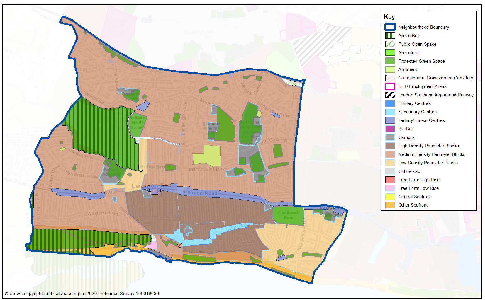
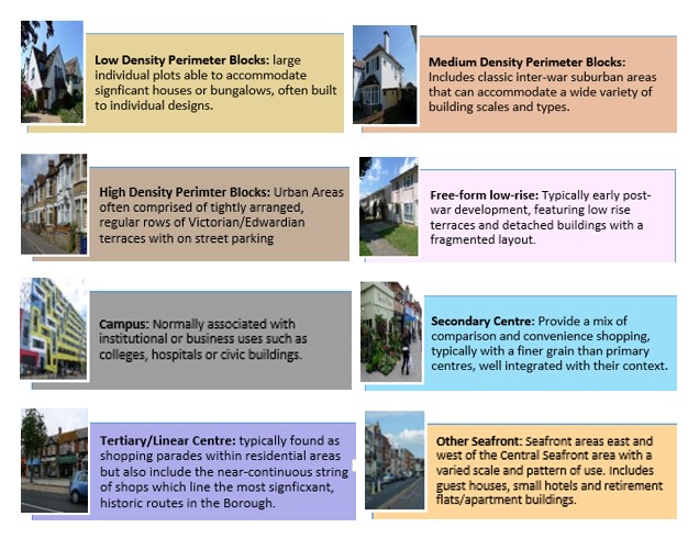
Map 21 shows the Urban Forms of Leigh neighbourhood. This has been informed by the Southend Borough Wide Character Study and is intended to provide a broad overview of the types and densities of development across the neighbourhood; this can range from low density, areas of detached housing, to high rise flats.
To assist with the preparation of development management and design policies, which will impact the scale, type and density of new homes, we are interested in your views on broadly what types of development you think should come forward in the neighbourhood. It may be that there are different parts of the neighbourhood that you think could accommodate different types of development.
Figure 17 provides a range of development typologies at different densities, for both houses and flats. We’d like to know whether there is a particular
typology that you’d like to see come forward in Leigh and within the different Urbans Forms as shown in Map 21. For instance you may believe the ‘Linear Centres’ within Map 21 should accommodate higher density development, such as flats typology F2 and F3, within Figure 17.
Figure 17 – Development Typologies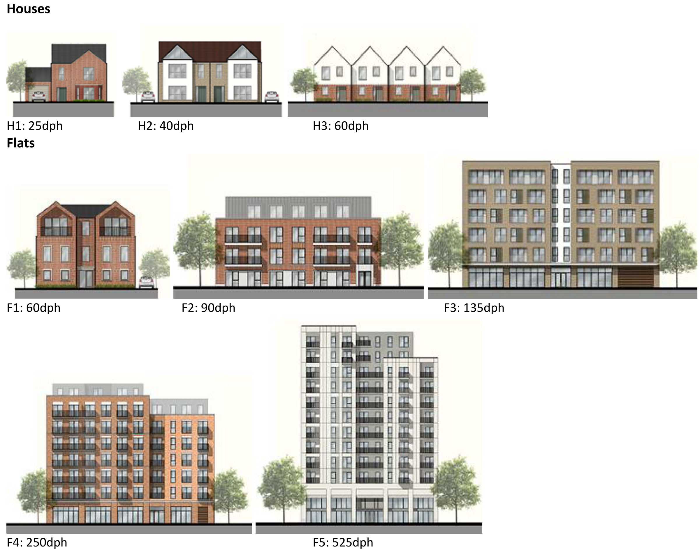
Map 21: Leigh Urban Forms
Question 3.2.4.2 Leigh (Urban Forms)
Have your say………
Please provide comment in support of your choice
a. Are there development typologies (Figure 17) that you would like to see come forward in Leigh? Please explain your answer – you may wish to refer to the different urban forms presented in Map 21 in your response.
To view our mapping feature showing Urban Forms: Southend-on-Sea Borough Council – Local Plan: Map 2 Urban Forms Map (opus4.co.uk)
3.2.4.3 Employment
The retention and provision of employment sites is necessary to enable balanced job and housing growth. However, employment land has relatively lower land values compared to residential and therefore it is important to safeguard or allocate sites to facilitate present and future economic growth. There are currently no designated employment sites in Leigh (the closest being to the northern side of the A127 within Eastwood). The working port at Old Leigh is an important part of the local economy, and maritime activities will continue to play a key role here, complemented by the leisure and tourism offer. Leigh will also continue to be a focus for creative and cultural industries.
3.2.4.4 Commercial Centres
To ensure the vitality of town centres, the National Planning Policy Framework encourages local planning authorities to implement planning policies and decisions that support the role that town centres play at the heart of local communities, by taking a positive approach to their growth, management, and adaptation.
The Government recently introduced changes to the Use Classes Order which consolidates a wide range of uses including retail, food, financial services, gyms, healthcare, nurseries, offices, and light industry into a single use class (Use Class E) and any change of use of a building or land between those uses falling within this Use Class will not require planning permission. It is therefore proposed to define as “Commercial Areas”, centres where we will promote ground floor uses to be within Class E Use Class and encourage improvements to shopfronts and the street scene.
There are a range of commercial centres in the Borough that protect ground floor uses for business purposes (use class E***) and thereby perform a vital function by ensuring communities are served by a range of retail and commercial services. Leigh contains an important district centre, complemented by other designated shopping areas, mainly focussed along the Broadway, Leigh Road and A13 London Road, with smaller pockets elsewhere within the neighbourhood providing important local provision (Map 22, Table 26).
As of August 2021, the Government is also introducing expanded permitted development rights to enable Commercial Uses to be converted to residential without planning permission. Due to this there are limitations on safeguarding ground floor commercial uses within key centres from changing to residential. However, under Article 4 of the General Permitted Development Order a local planning authority can apply to the Secretary of State to withdraw specified permitted development rights across a defined area. The use of Article 4 directions should not be expansive and therefore if we were to use them to restrict ground floor commercial uses from changing to residential, we must focus them to the most important frontages. In reference to Map 22 and Table 26 we are interested in your views on which centres we should investigate for using Article 4 Directions in order to restrict ground floor commercial frontages from being developed to residential under permitted development.
Map 22: Leigh Commercial Centres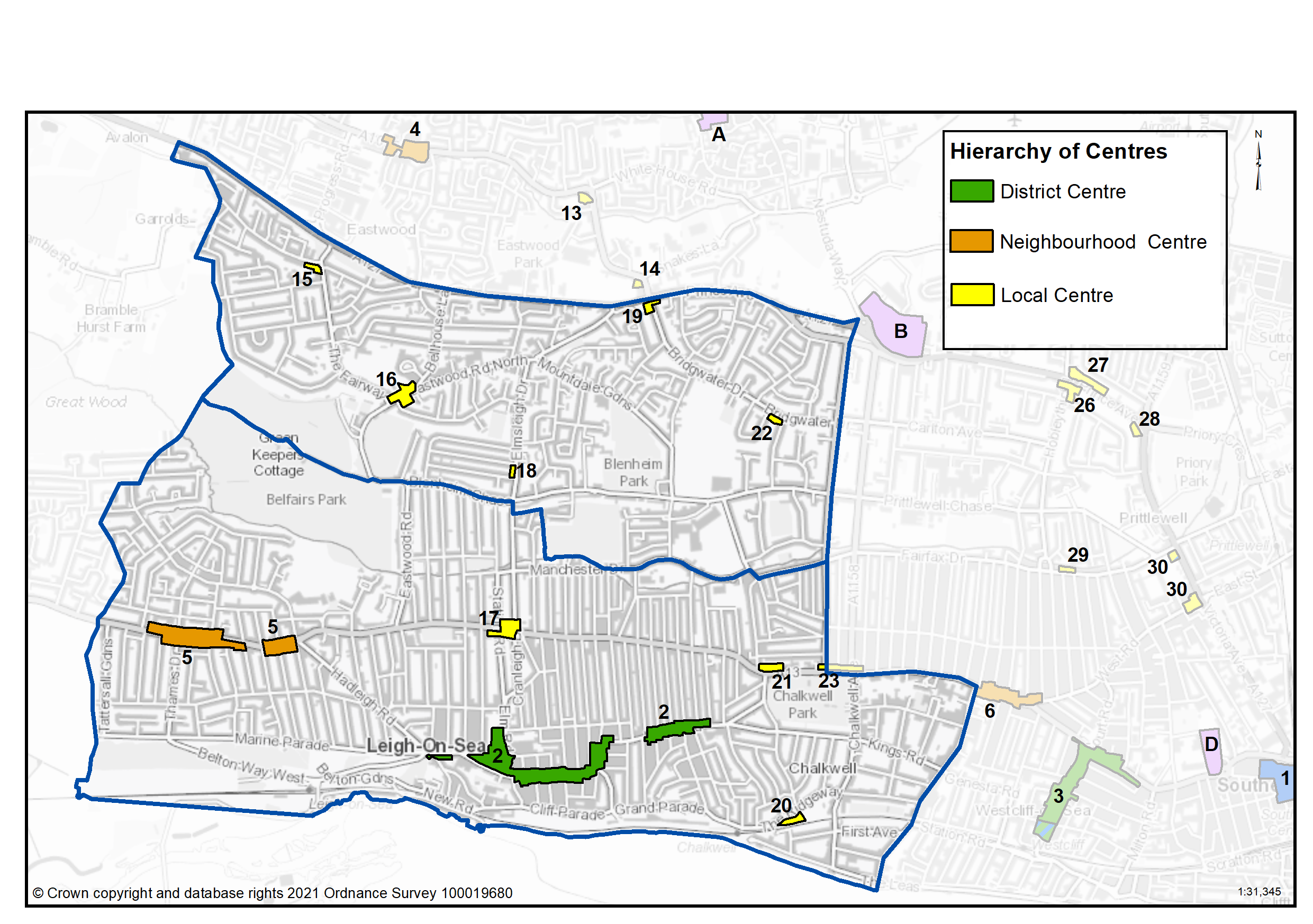
Table 26: Leigh Commercial Centres
|
Ref |
Name |
Centre Type |
|---|---|---|
|
2 |
Leigh (focussed along the Broadway) |
District Centre |
|
5 |
London Road (Thames Drive and Hadleigh Road) |
Neighbourhood Centre |
|
15 |
Eastwood Old Road |
Local Centre |
|
16 |
Eastwood Road |
Local Centre |
|
17 |
London Road, The Elms |
Local Centre |
|
18 |
Elmsleigh Drive |
Local Centre |
|
19 |
Bridgewater Drive, Kent Elms Corner |
Local Centre |
|
20 |
The Ridgeway |
Local Centre |
|
21 |
London Road, Chalkwell School |
Local Centre |
|
22 |
Bridgewater Drive South |
Local Centre |
Question 3.2.4.4a Leigh (Commercial)
Have your say......Please explain your answer
a) Should we seek to define Leigh (focussed along the Broadway) as a District Centre as set out in Table 26 to promote a range of commercial uses to serve local community needs and provide local employment opportunities?
a) Should we seek to define London Road (Thames Drive and Hadleigh Road) as a Neighbourhood Centre as set out in Table 26 to promote a range of commercial uses to serve local community needs and provide local employment opportunities?
a) Should we seek to define Eastwood Old Road as a Local Centre as set out in Table 26 to promote a range of commercial uses to serve local community needs and provide local employment opportunities?
a) Should we seek to define Eastwood Road as a Local Centre as set out in Table 26 to promote a range of commercial uses to serve local community needs and provide local employment opportunities?
a) Should we seek to define London Road, The Elms as a Local Centre as set out in Table 26 to promote a range of commercial uses to serve local community needs and provide local employment opportunities?
a) Should we seek to define Elmsleigh Drive as a Local Centre as set out in Table 26 to promote a range of commercial uses to serve local community needs and provide local employment opportunities?
a) Should we seek to define Bridgewater Drive, Kent Elms Corner as a Local Centre as set out in Table 26 to promote a range of commercial uses to serve local community needs and provide local employment opportunities?
a) Should we seek to define The Ridgeway as a Local Centre as set out in Table 26 to promote a range of commercial uses to serve local community needs and provide local employment opportunities?
a) Should we seek to define London Road, Chalkwell School as a Local Centre as set out in Table 26 to promote a range of commercial uses to serve local community needs and provide local employment opportunities?
a) Should we seek to define Bridgewater Drive South as a Local Centre as set out in Table 26 to promote a range of commercial uses to serve local community needs and provide local employment opportunities?
Question 3.2.41b Leigh (Residential)
Have your say......Please explain your answer
b) Should we investigate using Article 4 direction to safeguard ground floor commercial uses within the town, district and neighbourhood centres by restricting permitted development changes to residential – if so what frontages?
Question 3.2.41c Leigh (Residential)
Have your say......Please explain your answer
c. Are there any other areas within the Leigh Neighbourhood area that we haven’t identified that should be promoted for commercial activities? If yes, please explain your answer and let us know where.
3.2.4.5 Green Space
National planning policy allows for Local Plans to identify and protect existing green space so it is not built on unless an assessment demonstrates the open space, buildings or land are surplus to requirements; any open space lost would be replaced by equivalent or better provision in terms of quantity, quality and access; or the benefits of new sports and recreation facilities clearly outweigh the loss of the current or former use as open space. In this respect the New Local Plan seeks to protect the green spaces as set out in Table 27 and Maps 23 and 24.
Existing Open Space
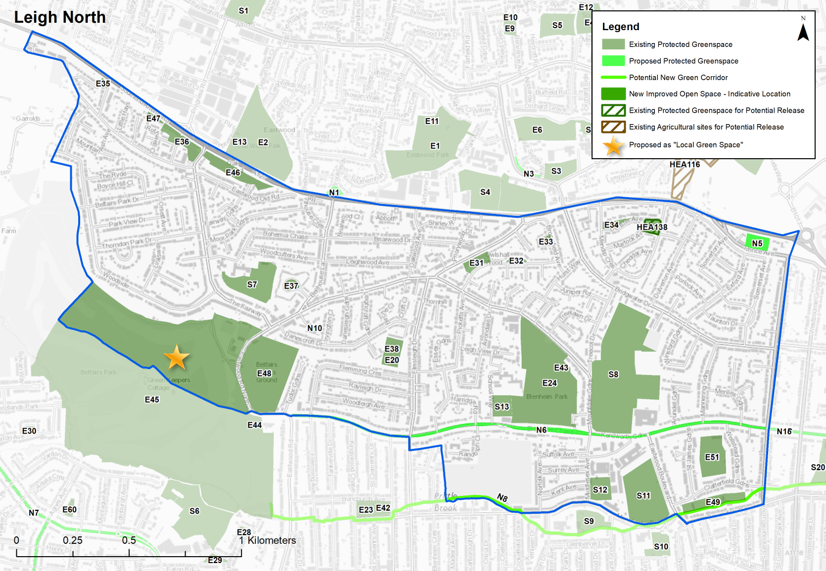
Leigh is well provided with a variety of open spaces, from the wild expanses of Two Tree Island and Leigh Marshes, Belfairs Woods, the formal gardens of Chalkwell Park, Ridgeway Gardens and Leigh Library Gardens, and more informal spaces such as Blenheim Park, Bonchurch Park, Marine Parade and Leigh Cliffs (Map 23 and Map 24). At the eastern edge of Leigh South, either side of the A13, south of Manchester Drive and north of Leigh Road, a section of Leigh is outside the walking catchment for local open space. The grid pattern of these streets limits potential for new green space, but tree planting and soft landscaping should be prioritised in this location. At the western edge of Leigh there is another area with a gap in provision, but nearby Belfairs Wood and Golf Course is accessible on foot from this area.
The Council’s Tree Policy aims to extend the overall tree canopy cover in the Borough from 12% to 15% by 2050. Tree Canopy cover within Leigh varies from 23.3% in Belfair Ward, the highest in the Borough reflecting the location of Belfairs Woods, 14.4% in West Leigh, 12.7% in Blenheim Ward, 12% in Chalkwell Ward, down to just 9.7% within Leigh Ward. Opportunities will be sought, particularly within Leigh Ward to plant additional street trees where appropriate.
The area between Chalkwell Park and Leigh Broadway (north and south of the London Road) is deficient in access to playgrounds as well as overlapping with the area deficient in access to local open space. Opportunities should be taken when development comes forward in this area to include children’s play space or pocket parks where feasible. While there are also gaps within the Marine and Highlands estates, these are closer to natural areas such as Two Tree Island and Belfairs Woods, which offer opportunities for natural play and are also more suburban in character with spacious gardens.
Local Green Space
National planning policy allows local authorities to designate land as Local Green Space through their local plans, so that communities can identify and protect green areas of particular importance to them, for example because of its historic significance, recreational value, tranquillity, beauty or richness of its wildlife. Policies for managing Local Green Space are consistent with those for Green Belts.
Proposed Local Green Space – Belfairs Woods has a unique character within Southend as the only significant expanse of woodland, and has nature conservation value, and educational value through outdoor classrooms. Essex Wildlife Trust also have a visitor centre adjacent to the woods. For these
reasons it is proposed to designate it as Local Green Space. This is a way to provide special protection against development for green areas of particular importance to local communities. The outcome of this consultation will be particularly important in demonstrating that the space is special to the community. It is also proposed to designate Leigh Library Gardens as Local Green Space. The gardens were awarded a Green Flag in 2020 and have an active Friends group. This is a valued local green space connected with the public library, and located within a dense urban area, offering tranquillity, access to nature and space to play.
Proposed new Green Space Sites to be protected (Table 27a)
Highlands Boulevard and Sutherland Boulevard are wide green verges which are public land maintained by the Council. It is proposed to designate these as Linear Green Space, due to their value as wildlife corridors, visual and recreational amenity. Blenheim/Prittlewell Chase is proposed as a Linear Green Space for the same reason.
Millennium Open Space, just to the south of the A127, is proposed to be protected as a Local Park. This space is high quality with a woodland area and picnic benches.
The entire length of the Prittle Brook (from Belfairs Woods to Priory Park) is an important green corridor and waterway for wildlife, and pedestrian and cycle route for recreation and active travel. The Prittle Brook, along with the Victory Path which links the Ridgeway to Crowstone Road are proposed to be designated as Green Corridors, where biodiversity will be protected and enhanced and the route promoted for walking and cycling.
An area of search has also been identified either side of the London Road from Leigh Road to Manchester Drive where there is a deficiency in local open space and children’s play space. The area has relatively narrow parallel streets so any improvements to green space could be focussed within London Road where opportunities arise.
Green Space proposed for release
Mendip Crescent is a large area of green space within the centre of residential housing development, bordered to the east by Medlock Avenue, the north by Dunster Avenue and east by Mendip Crescent. The site is Council owned and considered potentially available for future redevelopment (site HEA138). The site has been assessed by the Council as potentially suitable for 4 – 8 houses. Given this site is designated parks and open space, it is envisioned that further public consultation would be required in terms of its potential release.
Map 23: Protected Green Space in Leigh (north)
Map 24: Protected Open Space in Leigh (south)
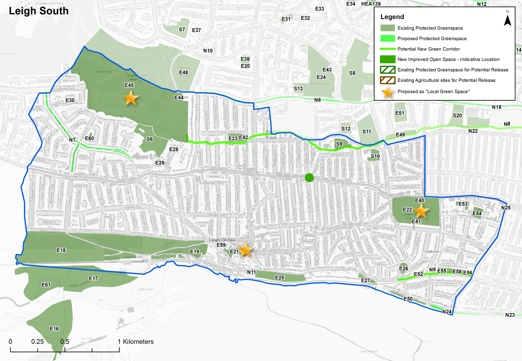
Table 27: Leigh – Protected Green Space
| Site Ref. | Name of Site | Size (Ha) | Site Ref. | Name of Site | Size (Ha) | |
|---|---|---|---|---|---|---|
|
Nature Reserve |
Woodland |
|||||
|
E16 |
Two Tree Island |
11.869 |
E45 |
Belfairs Woods and Golf Course |
67.402 |
|
|
E17 |
Leigh Marshes |
17.555 |
E46 |
Oakwood |
1.242 |
|
|
E18 |
Belton Hills Nature Reserve |
32.243 |
E47 |
Woods North of Rothwell Close |
0.138 |
|
|
Local Park |
Sports Ground |
|||||
|
E19 |
Belton Gardens |
3.573 |
E48 |
Belfairs Sports Ground |
6.060 |
|
|
E20 |
Danescroft Gardens |
0.874 |
E49 |
Cavendish Sports Ground |
1.150 |
|
|
E21 |
Leigh Library Gardens |
0.820 |
E50 |
Chalkwell Esplanade |
0.602 |
|
|
E22 |
Chalkwell Park |
10.143 |
E51 |
Wellstead Gardens |
1.910 |
|
|
E23 |
Bonchurch Park |
0.789 |
E52 |
Westcliff Tennis Club |
0.352 |
|
|
E24 |
Blenheim Park |
9.200 |
E53 |
Westcliff Lawn Tennis Club |
0.567 |
|
|
E25 |
Leigh Cliffs |
3.084 |
E54 |
Imperial Avenue Bowling Green |
0.795 |
|
|
Amenity Open Space |
E55 |
Invicta Tennis Club |
0.377 |
|||
|
E26 |
Ridgeway Gardens |
0.525 |
E56 |
Crowstone School Sports Ground |
0.199 |
|
|
E27 |
Undercliff Gardens |
0.633 |
E57 |
Leigh Road Baptist Tennis Club |
0.238 |
|
|
E28 |
Underwood Square |
0.155 |
E58 |
Crowstone Church Tennis Courts |
0.300 |
|
|
E29 |
Fairview Gardens |
0.259 |
E59 |
Leigh Bows Club - Rectory Grove |
0.061 |
|
|
E30 |
Buxton Square |
0.117 |
E60 |
Leigh Tennis Club - Adalia Crescent |
0.244 |
|
|
E31 |
Owlshall Wood |
0.539 |
E61 |
Golf Range - Two Tree Island |
2.919 |
|
|
E32 |
Stonehill Road |
0.166 |
School |
|||
|
E33 |
Broomfield Avenue |
0.170 |
S6 |
Belfairs High |
4.664 |
|
|
E34 |
Dunster Avenue |
0.285 |
S7 |
Fairways School |
2.418 |
|
|
E35 |
Belgrave Road |
0.095 |
S8 |
St Thomas More HIgh School |
11.325 |
|
|
E36 |
Bradfordbury Open Space |
0.971 |
S9 |
Darlinghurst School |
1.074 |
|
|
Pocket Park/Playground |
S10 |
Our Lady of Lourdes |
0.894 |
|||
|
E37 |
Wood Farm Close |
0.251 |
S11 |
Westcliff Boys |
3.916 |
|
|
Playground |
S12 |
Westcliff Girls |
0.932 |
|||
|
E38 |
Danescroft Gardens Park Play Area |
0.044 |
S13 |
Blenheim Primary Playing Fields |
0.794 |
|
|
E39 |
Leigh Library Gardens Play Area |
0.029 |
|
Allotments |
||
|
E40 |
Chalkwell Park playground (older) |
0.203 |
A1 |
Bridgewater Drive |
0.499 |
|
|
E41 |
Chalkwell Park playground (toddler) |
0.167 |
A2 |
Manchester Drive |
8.725 |
|
|
E42 |
Bonchurch Childrens Play Area |
0.280 |
A3 |
Marshall Close |
0.277 |
|
|
E43 |
Blenheim Park Play Area |
0.189 |
Crematorium, Graveyard or Cemetry |
|||
|
E44 |
Belfairs Park Playground |
0.118 |
C1 |
Leigh |
1.174 |
|
|
|
C2 |
St Clement’s Church |
0.327 |
|||
|
Release Site |
||||||
|
HEA138 |
Mendip Crescent |
0.393 |
||||
Sites in Bold are proposed as ‘Local Green Space’
Table 27a: Leigh – Proposed Green Space Allocations
Individual sites listed below with question
Table 27b: Land Use Proposals in Leigh – Green Space Currently Protected but with potential for release
Individual sites listed below with question
3.2.4.5a Leigh (Green Space)
Have your say………
N5... Millennium Open Space
Local Park
Site Ref - N5
Name of Site - Millennium Open Space
Size (Ha) - 0.610
Question a - Do you support the proposed new new green space designation at Millennium Open Space? If not, can you explain why?
N6... Blenheim Chase/Kenilworth Gardens (further details)
Linear Green Space
Site Ref - N6
Name of Site - Blenheim Chase/Kenilworth Gardens
Size (Ha) - 2.160
Question a - Do you support the proposed new new green space designation at Blenheim Chase/Kenilworth Gardens? If not, can you explain why?
N7... Highlands Boulevard/Sutherland Boulevard (further details)
Linear Green Space
Site Ref - N7
Name of Site - Highlands Boulevard/Sutherland Boulevard
Size (Ha) - 1.662
Question a - Do you support the proposed new new green space designation at Highlands Boulevard/Sutherland Boulevard. If not, can you explain why?
N8... Prittle Brook (further details)
Green Corridor
Site Ref - N8
Name of Site - Prittle Brook
Size (Ha) - 4.225m
Question a - Do you support the proposed new new green space designation at Prittle Brook? If not, can you explain why?
N9... Victory Path Ridgeway to Crowstone Road (further details)
Green Corridor
Site Ref - N9
Name of Site - Victory Path Ridgeway to Crowstone Road
Size (Ha) - 689m
Question a - Do you support the proposed new new green space designation at Victory Path Ridgeway to Crowstone Road? If not, can you explain why?
N10... Oak Walk Pocket Park (further details)
Pocket Park/ Playground
Site Ref - N10
Name of Site - Oak Walk Pocket Park
Size (Ha) - 0.065
Question a - Do you support the proposed new new green space designation Oak Walk Pocket Park? If not, can you explain why?
N11... The Gardens (further details)
Pocket Park/ Playground
Site Ref - N11
Name of Site - The Gardens
Size (Ha) - 0.056
Question a - Do you support the proposed new new green space designation at The Gardens? If not, can you explain why?
Question 3.2.4.5b Leigh (Green Space)
HEA138 Mendip Crescent (further details)
Designated Green Space
Site Ref - HEA138
Name of Site - Mendip Crescent
Size (Ha) - 0.39
Area of Deficiency - N
Potential Housing Capacity (net) - 6
Justification - Land is in public ownership and underutilised, with potential for residential development.
Question - Do you agree with the potential release of Mendip Crescent for development? Please explain your answer.
Question b - Do you agree with the potential release of Mendip Crescent for development? Please explain your answer.
Question 3.2.45c Leigh (Green Space)
Question c. Do you agree that the areas identified as deficient in green space should be promoted for additional tree planting, soft landscaping or children’s play space where opportunities arise through new development?
Question 3.2.4.5d Leigh (Green Space)
E45 - Belfairs Woods and Golf Course (further details)
Woodland
Site Ref - E45
Name of Site - Belfairs Woods and Golf Course
Size (Ha) - 67.402
Question d - Do you agree with Belfairs Woods and Golf Course being proposed as Local Green Space? If not, can you explain why?
E22 - Chalkwell Park (further details)
Local Park
Site Ref - E22
Name of Site - Chalkwell Park
Size (Ha) - 10.143
Question d - Do you agree with Chalkwell Park being proposed as Local Green Space? If not, can you explain why?
E21 - Leigh Library Gardens (further details)
Local Park
Site Ref - E21
Name of Site - Leigh Library Gardens
Size (Ha) - 0.820
Question d - Do you agree with Leigh Library Gardens being proposed as Local Green Space? If not, can you explain why?
Question 3.2.4.5e Leigh (Green Space)
Question e - Do you propose any other sites should be designated as Local Green Space? If yes, please provide an address and supporting evidence that outlines how the space is special to the local community in terms of beauty, historic significance, recreational value, tranquillity, wildlife or for other reasons.
Question 3.2.4.5f Leigh (Green Space)
Question f - Do you have any other comments regarding green space in Leigh? If yes, please explain your answer.
*nurseries, primary schools, secondary schools, doctors, dentists, pharmacies, libraries, places of worship, public conveniences, community centres and halls, playing pitches, local equipped play space, amenity greenspace, allotments, natural and semi-natural greenspace, local and neighbourhood centres, town and district centres
**190617_Old_Leigh_Spatial_Plan_Final_low_res.pdf (leighonseatowncouncil.gov.uk)