3.3.1 General Character
Prittlewell forms the gateway to the town centre, with the A127 (Prince Avenue) forming a central spine through the area (Map 25). Prittlewell is largely characterised by low and medium density inter-war housing, particularly on key routes, although there are also substantial areas of post and some pre- fabricated housing. There is a key historic element to the neighbourhood, largely focussed around East and West Street and the junction with the busy Victoria Avenue, including St Mary’s Church and the historic Prittlewell Priory in Priory Park to the north. Generally, population density is low within the area, although this is skewed by the presence of parks and open spaces, including allotment gardens and open land associated with the airport. Where there are areas of higher density these tend to correlate with key movement corridors and local centres.
Prittlewell is home to a number of key focal points, including Southend University Hospital (Prittlewell Chase), Fair Havens Hospice (Priory Crescent) and Southend United Football Club (Roots Hall). Prittlewell does not have a particularly large retail centre, with the closest being Southend town centre. There is however a range of local provision, including a large Tesco store and a number of local centres. The neighbourhood includes the highway access to London Southend Airport, the majority of which is situated within the adjoining Rochford district, and related retail park. There are two local employment areas at Priory Works and Thanet Grange. The area has a main line railway station (Prittlewell) and bus connections to the town centre, airport and beyond.
Key issues in the area include the redevelopment of Roots Hall and improving accessibility to east Southend due to the severance caused by Southend Victoria railway line.
Map 25: Prittlewell Characteristics
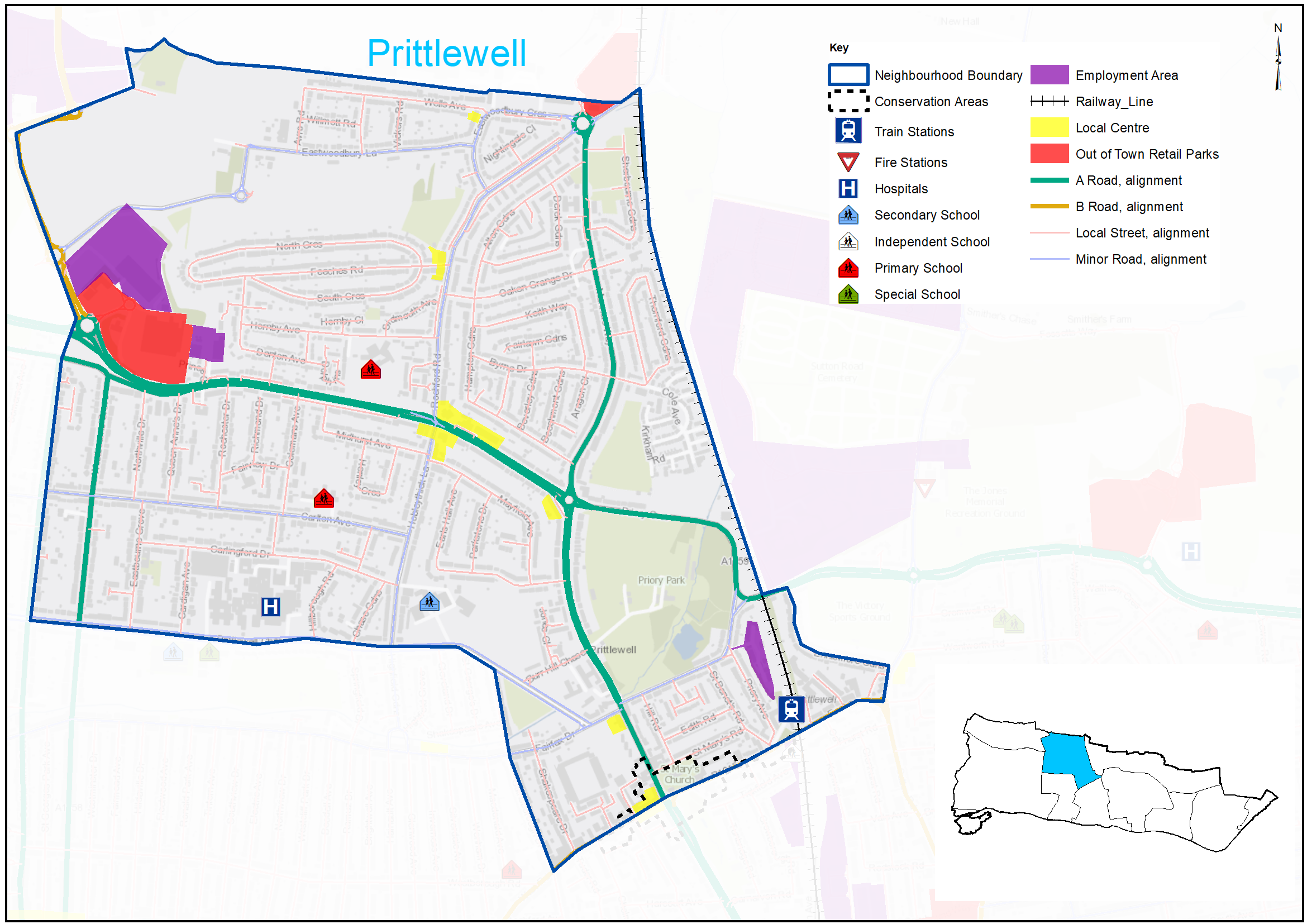
Figure 18: Prittlewell Characteristics
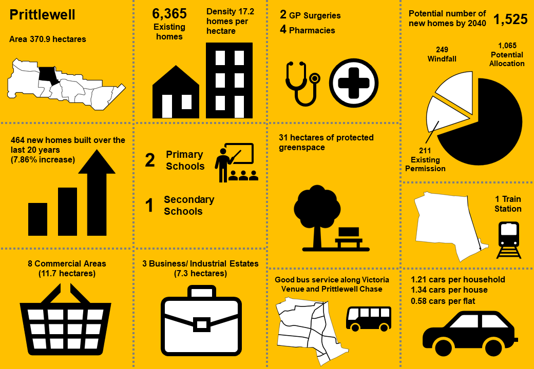
|
No. Homes |
6,365 |
Land Area (ha) |
370.9 |
|
Density |
17.2dph |
Car Ownership |
1.21 |
3.3.2 Vision - Prittlewell
Where we want to be
The historic settlement focussed around the junction of East and West Street with Victoria Avenue and public open spaces including Priory Park will be conserved and enhanced, and the important role of Victoria Avenue as a key transport corridor will continue to be supported. Opportunities for additional homes will be focussed on key transport corridors and will be sympathetic in character with its surrounding context. As development comes forward opportunities will be sought to enhance connections between existing open spaces, and increase soft landscaping and tree cover within the area. A draft set of priorities for Prittlewell is set out below to aid feedback:
- Focus residential development along key transport corridors and improve air quality through design and landscaping mitigation and public transport enhancements.
- Victoria Avenue (A127) will continue to play an important role as the main approach to Southend town centre by road, and a new road link from the A127 at the Tesco roundabout to Warners Bridge will improve accessibility to the east of the Borough.
- Support the economic role of London Southend Airport and mitigate impacts on the local environment, including improved surface access for all transport modes to the Airport and railway station.
- Conserve and enhance designated heritage assets including St Mary’s Church and Prittlewell Priory Scheduled Ancient Monument and the distinctive character of Prittlewell Conservation Area.
- Enhance parks and open spaces and improve walking and cycling links where feasible, whilst considering potential agricultural land and smallholdings at Eastwoodbury Lane to be released to realise strategic transport and housing ambitions.
- Promote the employment areas at Priory Works and Thanet Grange for retention and renewal. Redevelop Prince Close employment area.
Question 3.3.2 Prittlewell (Vision)
Have your say………
Please explain your answers
a. Do you agree with our draft vision and priorities for Prittlewell? If not, let us know what we have missed.
3.3.3 Complete Neighbourhoods (accessibility to services and facilities)
The following profile seeks to build up a picture of the ‘completeness’ of Prittlewell. Completeness is based on mapping the walking catchments around different day to day facilities (17 different facilities in total) *. The catchment areas vary by facility and reflect comfortable walking distances for the average, able-bodied person. The catchments are based on actual walking routes rather than ‘as the crow flies’ distances.
A high completeness score means a place has lots of facilities the community needs within an easy walking distance. This approach recognises the important links to health and social well-being, community cohesion and inclusion.
The completeness score for Prittlewell, by infrastructure type, is summarised in the rainbow image below. For example 51% of the neighbourhood lies within walking distance to a health facility, 86% of the neighbourhood is within reach of sports and leisure facilities, while 18% is within an easy walk of green space.
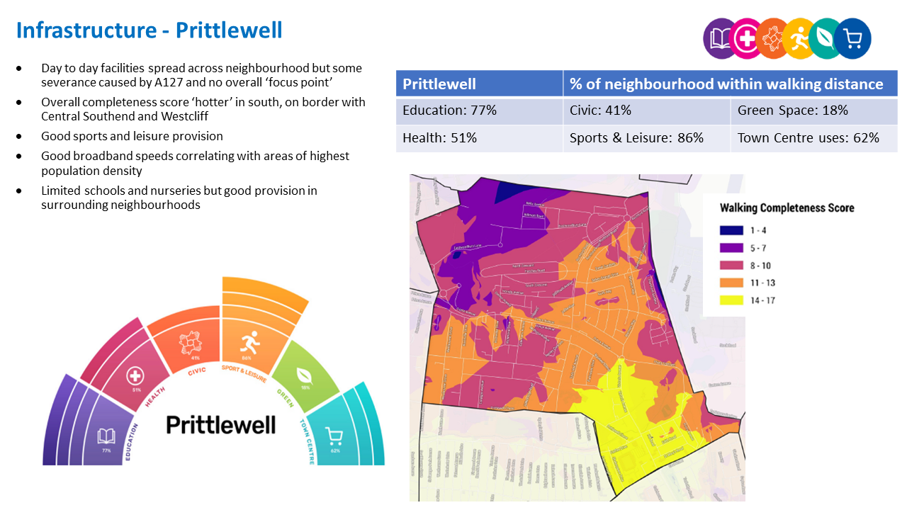
Prittlewell ‘Aggregated Completeness Score’ = 56%
Map – as an example a high completeness score would be 14 –17 different facilities being within a reasonable walking distance from home. Conversely a low score would be less than 4 facilities within walking distance.
Question 3.3.3 Prittlewell (Infrastructure)
Have your say…….
Please explain your answer
a. Are there any issues with infrastructure provision in Prittlewell? Please explain your answer and let us know what the priorities should be over the next 20 years?
3.3.4 Land Use Proposals - Prittlewell
A number of potential land use proposals are identified for future housing, employment and open space. For each site, the location, proposed use and indicative amount of development (if applicable) is provided.
3.3.4.1 New Homes
The type and quality of the housing offer can have a significant impact on the health and wealth of places. Their ability to attract and retain people and provide support for those who need it relies on good housing and attractive and inclusive neighbourhoods.
Potential site proposals for residential development can be viewed in Map 26. Table 28 sets outs relevant information including, context and surrounding uses, proposed use, estimated number of new and what ‘components of growth’ the site contributes to in reference to Section 2: Housing Need (Table 2).
The sites have been promoted to us by landowners/ agents and are included here for comment. Table 28 also notes the amount of new homes that are likely to come forward over the lifetime of the plan through sites already with planning permission and windfall development.
For more information on each site an assessment can be viewed by clicking on the link reference in Table 28 below, or via the Council’s website: Appendix 4: Site Proformas | Southend Local Plan
Map 26: Potential Residential Sites - Prittlewell
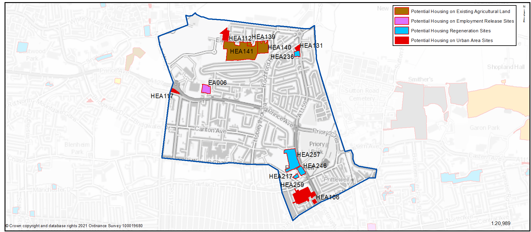
Table 28: Potential Residential Sites - Prittlewell
Question 3.3.41a Prittlewell (Residential)
HEA106... Industrial uses between Roots Hall Avenue and Victoria Avenue
HEA106
Context/ Surrounding Uses - The site comprises an area of surface parking, a single storey building dating from the 1920’s and a two-storey building which is currently in use as a Kung Fu Centre. Whilst the site remains largely in use, the land is underutilised with a large area of hard surfacing/ parking. The site is a backland plot surrounded to the north and west by two storey terraced dwellings. Roots Hall House is located to the south of the site and includes a 3-storey building of the little architectural merit with retail to the ground floor. Unimplemented Local Plan site from the former Borough Local Plan (1994).
Potential Land Use - Residential (flatted) development.
Potential Land Use Summary - Residential Led
Component Change - Urban Area General
Estimated Number of Homes gross 8 - Net 8
| https://localplan.southend.gov.uk/sites/localplan.southend/files/2021-08/Prittlewell%20Proformas.pdf#page=4 |
Question a - Do you agree with the potential proposals for this site? Please explain your answer. You may wish to outline the type and scale of development you would like to see come forward in reference to Figure 19: Development Typologies
Question 3.3.41a Prittlewell (Residential)
HEA112...Avro Centre, Avro Road
HEA112
Context/ Surrounding Uses - This site currently includes a single storey building (of limited architectural merit) in use as an adult training centre. The site also includes parking / hardstanding to the front of the building, and portacabins and substation to the western boundary. The opposite side of Avro Road includes 2 storey residential properties. To the north/ west of the site lies the Southend Airport Runway.
Potential Land Use - This Council owned site has been submitted through the Call for Sites process. Residential development will need to take account proximity of airport
Potential Land Use Summary - Residential development
Component Change - Urban Area General
Estimated Number of Homes gross 50 - Net 50
| https://localplan.southend.gov.uk/sites/localplan.southend/files/2021-08/Prittlewell%20Proformas.pdf#page=5 |
Question a - Do you agree with the potential proposals for this site? Please explain your answer. You may wish to outline the type and scale of development you would like to see come forward in reference to Figure 19: Development Typologies
Question 3.3.41a Prittlewell (Residential)
HEA117... Vacant Land between Prince Avenue and A127
HEA117
Context/ Surrounding Uses - Site includes an area of vacant grassland consisting of two small fields. There is a Cattery immediately to the west, The site is located between the A127 and Prince Avenue (A1158) and there is a large roundabout to the north. The surrounding area is largely residential, with Thanet Grange commercial area to the north/north east.
Potential Land Use - This council owned site has been submitted through the Call for Sites process as a site suitable for residential development. This would allow for the provision of a new access and some re-provision of open space to mitigate the scheme and potential noise impacts associated with the adjacent roundabout.
Potential Land Use Summary - Residential development (subject to site access)
Component Change - Urban Area General
Estimated Number of Homes gross 8 - Net 8
| https://localplan.southend.gov.uk/sites/localplan.southend/files/2021-08/Prittlewell%20Proformas.pdf#page=6 |
Question a - Do you agree with the potential proposals for this site? Please explain your answer. You may wish to outline the type and scale of development you would like to see come forward in reference to Figure 19: Development Typologies
Question 3.3.41a Prittlewell (Residential)
HEA131...St Stephen's Church, vicarage and play area, Manners Way
HEA131
Context/ Surrounding Uses - Site located on corner of Alton Gardens and Manners Way, includes a church and adjacent vicarage, as well as a children’s playground. There are allotments to the east, and predominantly residential properties to the south and west, largely 2 storey. Southend Airport and the business park are to the north.
Potential Land Use - The site, (including the church buildings only) could potentially deliver 13 dwellings.
Potential Land Use Summary - Residential led with potential for playground reprovision
Component Change - Urban Area General
Estimated Number of Homes gross 13 - Net 13
| https://localplan.southend.gov.uk/sites/localplan.southend/files/2021-08/Prittlewell%20Proformas.pdf#page=7 |
Question a - Do you agree with the potential proposals for this site? Please explain your answer. You may wish to outline the type and scale of development you would like to see come forward in reference to Figure 19: Development Typologies
Question 3.3.41a Prittlewell (Residential)
HEA259... Roots Hall Stadium
HEA259
Context/ Surrounding Uses - Comprises Southend Roots Hall Stadium, car park and surrounding land. The site is in a mixed area with industrial and residential uses adjacent to the stadium.
Potential Land Use - The site is located within a suitable area for housing. The site may become available if the football stadium’s relocation is confirmed to Fossetts Farm.
Potential Land Use Summary - Residential development
Component Change - Urban Area General
Estimated Number of Homes gross 502 - Net 502
| https://localplan.southend.gov.uk/sites/localplan.southend/files/2021-08/Prittlewell%20Proformas.pdf#page=15 |
Question a - Do you agree with the potential proposals for this site? Please explain your answer. You may wish to outline the type and scale of development you would like to see come forward in reference to Figure 19: Development Typologies
Question 3.3.41a Prittlewell (Residential)
HEA217... Land at Prittlewell Chase, adjacent to Priory House
HEA217
Context/ Surrounding Uses - Part 1 and 2 storey care home. Mix of uses nearby including residential. West of Prittlewell Chase road and North of Prittle Brook.
Potential Land Use - Existing building in public ownership that may benefit from some renewal, redevelopment or expansion that could provide new and better quality homes that are designed to be adaptable so local people can reside independently through all stages of their lives. To gain a comprehensive understanding of development potential, all existing housing estates in public ownership have been included for comment.
Potential Land Use Summary - Residential development
Component Change - Housing Regeneration Sites
Estimated Number of Homes gross 28 - Net 0
| https://localplan.southend.gov.uk/sites/localplan.southend/files/2021-08/Prittlewell%20Proformas.pdf#page=6 |
Question a - Do you agree with the potential proposals for this site? Please explain your answer. You may wish to outline the type and scale of development you would like to see come forward in reference to Figure 19: Development Typologies
Question 3.3.41a Prittlewell (Residential)
HEA236...Nayland House, 203 Manners Way
HEA236
Context/ Surrounding Uses - Part 1 and 2 storey sheltered housing. In a low residential area fronting the A1159. Allotments to the east with Southend Airport c.300m north.
Potential Land Use - Existing building in public ownership that may benefit from some renewal, redevelopment or expansion that could provide new and better quality homes that are designed to be adaptable so local people can reside independently through all stages of their lives. To gain a comprehensive understanding of development potential, all existing housing estates in public ownership have been included for comment. At the time of publication of this document no Council decision has been made on redeveloping this site.
Potential Land Use Summary - Residential development
Component Change - Housing Regeneration Sites
Estimated Number of Homes gross 43 - Net 16
| https://localplan.southend.gov.uk/sites/localplan.southend/files/2021-08/Prittlewell%20Proformas.pdf#page=12 |
Question a- Do you agree with the potential proposals for this site? Please explain your answer. You may wish to outline the type and scale of development you would like to see come forward in reference to Figure 19: Development Typologies
Question 3.3.41a Prittlewell (Residential)
HEA246...Stephen McAdden House, 21 Burr Hill Chase
HEA246
Context/ Surrounding Uses - Group of part 1, 2 & 3 storey residential buildings currently in use as sheltered accommodation. Adjacent to Priory Park, residential uses, and care home.
Potential Land Use - Existing building in public ownership that may benefit from some renewal, redevelopment or expansion that could provide new and better quality homes that are designed to be adaptable so local people can reside independently through all stages of their lives. To gain a comprehensive understanding of development potential, all existing housing estates in public ownership have been included for comment. At the time of publication of this document no Council decision has been made on redeveloping this site.
Potential Land Use Summary - Residential development
Component Change - Housing Regeneration Sites
Estimated Number of Homes gross 115 - Net 49
| https://localplan.southend.gov.uk/sites/localplan.southend/files/2021-08/Prittlewell%20Proformas.pdf#page=13 |
Question a - Do you agree with the potential proposals for this site? Please explain your answer. You may wish to outline the type and scale of development you would like to see come forward in reference to Figure 19: Development Typologies
HEA257... Cecil Court
HEA257
Context/ Surrounding Uses - 2 & 3 storey properties accessed via Burr Hill Chase and a 12 storey tower block. Site adjacent to Southend High School for Boys with surrounding residential uses and Priory Park.
Potential Land Use - Existing building in public ownership that may benefit from some renewal, redevelopment or expansion that could provide new and better quality homes that are designed to be adaptable so local people can reside independently through all stages of their lives. To gain a comprehensive understanding of development potential, all existing housing estates in public ownership have been included for comment. At the time of publication of this document no Council decision has been made on redeveloping this site.
Potential Land Use Summary - Residential development
Component Change - Housing Regeneration Sites
Estimated Number of Homes gross 287 - Net 109
| https://localplan.southend.gov.uk/sites/localplan.southend/files/2021-08/Prittlewell%20Proformas.pdf#page=14 |
Question a - Do you agree with the potential proposals for this site? Please explain your answer. You may wish to outline the type and scale of development you would like to see come forward in reference to Figure 19: Development Typologies
Question 3.3.41a Prittlewell (Residential)
HEA139...Land to the South of Eastwoodbury Lane (East)
HEA139
Context/ Surrounding Uses - Greenfield small holdings adjacent to residential dwellings to the east, south of Eastwoodbury Lane. Further open space/ agricultural land to the south / west. The immediate surrounding area is primarily residential. It is close to the Southend Airport Runway, to the north.
Potential Land Use - Potential for residential development. Consideration of existing green space and small holdings will need to be considered if the site comes forward. It is likely this site should be considered alongside HEA140 & HEA141.
Potential Land Use Summary - Residential development
Component Change - Agricultural Land/ Green Space
Estimated Number of Homes gross 10 - Net 10
| https://localplan.southend.gov.uk/sites/localplan.southend/files/2021-08/Prittlewell%20Proformas.pdf#page=8 |
Question a - Do you agree with the potential proposals for this site? Please explain your answer. You may wish to outline the type and scale of development you would like to see come forward in reference to Figure 19: Development Typologies
Question 3.3.41a Prittlewell (Residential)
HEA140...Land to the South of Eastwoodbury Lane (West)
HEA140
Context/ Surrounding Uses - Greenfield small holdings adjacent to residential dwellings to the east, south of Eastwoodbury Lane. Further open space/ agricultural land to the south / west. The immediate surrounding area is primarily residential. It is close to the Southend Airport Runway, to the north.
Potential Land Use - Potential for a number of different uses, including residential, new transport access, and improvements to remaining green space. Consideration of existing green space and small holdings required if the site comes forward. It is likely this site should be considered alongside HEA139 & HEA141.
Potential Land Use Summary - Potential for a number of different uses, including residential, new transport access, and green space.
Component Change - Agricultural Land/ Green Space
Estimated Number of Homes gross 81 - Net 81
| https://localplan.southend.gov.uk/sites/localplan.southend/files/2021-08/Prittlewell%20Proformas.pdf#page=9 |
Question a - Do you agree with the potential proposals for this site? Please explain your answer. You may wish to outline the type and scale of development you would like to see come forward in reference to Figure 19: Development Typologies
Question 3.3.41a Prittlewell (Residential)
HEA141...Land to the South of Eastwoodbury Lane
HEA141
Context/ Surrounding Uses - Greenfield site located on agricultural land south of Eastwoodbury Lane adjacent to residential properties. To the east is open space / agricultural land. To west is St Laurence Park. Close to Southend Airport Runway to the north.
Potential Land Use - Potential for a number of different uses, including residential, new transport access, and improvements to remaining green space. If new transport access is provided a portion St Laurence Park will need to be re-positioned. Consideration of existing green space and agricultural land required if the site comes forward. It is likely this site should be considered alongside HEA139 & HEA140.
Potential Land Use Summary - Potential for a number of different uses including: new school, new transport access, residential development.
Component Change - Agricultural Land/ Green Space
Estimated Number of Homes gross 180 - Net 180
| https://localplan.southend.gov.uk/sites/localplan.southend/files/2021-08/Prittlewell%20Proformas.pdf#page=10 |
Question a - Do you agree with the potential proposals for this site? Please explain your answer. You may wish to outline the type and scale of development you would like to see come forward in reference to Figure 19: Development Typologies
Question 3.3.41a Prittlewell (Residential)
HEA260...Aldi Store, Eastern Avenue
HEA260
Context/ Surrounding Uses - Aldi supermarket with car parking. Site adjacent to sewage works, car wash, and a waste collection depot. The railway line is west with industrial uses North.
Potential Land Use - The site is not suitable for housing development given its designation for employment uses and adjacent uses that affect amenity. The site remains suitable for employment redevelopment.
Potential Land Use Summary - Mixed Use
Component Change - Urban Area General
Estimated Number of Homes Not Suitable
Question a - Do you agree with the potential proposals for this site? Please explain your answer. You may wish to outline the type and scale of development you would like to see come forward in reference to Figure 19: Development Typologies
Question 3.3.41a Prittlewell (Residential)
EA006...Prince Close
EA006
Context/ Surrounding Uses - Existing employment site. Mixed industrial estate north of the A127 adjacent to a Tesco Extra and residential uses. The continued employment use at this site has been severely reduced by recent permissions for residential development. Once the permissions are implemented the site will lose most of its employment footprint and this combined with its context and restricted access do not make it attractive for employment investment.
Potential Land Use - The site offers the potential for residential development.
Potential Land Use Summary - Residential Led
Component Change - Employment Release Site
Estimated Number of Homes gross 39 - Net 39
| https://localplan.southend.gov.uk/sites/localplan.southend/files/2021-08/Prittlewell%20Proformas.pdf#page=1 |
Question a - Do you agree with the potential proposals for this site? Please explain your answer. You may wish to outline the type and scale of development you would like to see come forward in reference to Figure 19: Development Typologies
Question 3.3.41b Prittlewell (Residential)
Have your Say..
b. Do you have any other comments on housing provision in Prittlewell? If yes, please explain your answer.
3.3.4.2 Urban Form and Development Typologies
Good quality urban design will be essential in new housing development if the character of the neighbourhood is to be enhanced.
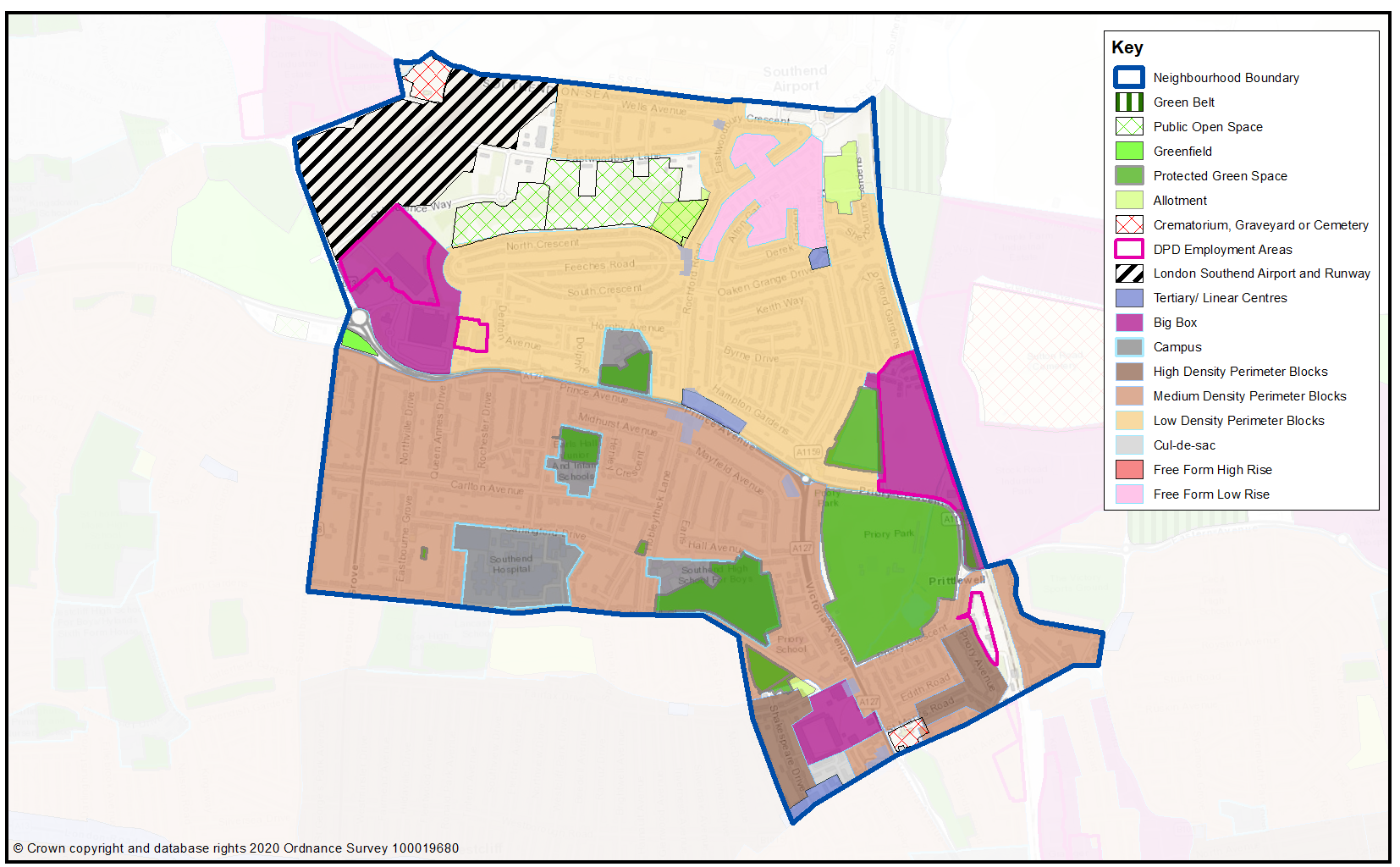
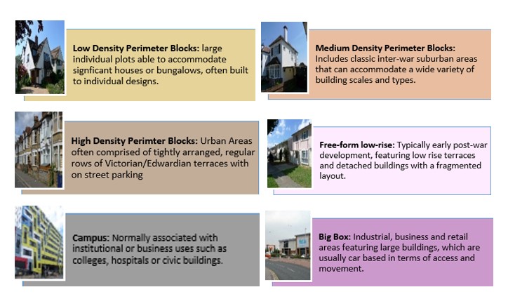
Map 27 shows the Urban Forms of Prittlewell neighbourhood. This has been informed by the Southend Borough Wide Character Study and is intended to provide a broad overview of the types and densities of development across the neighbourhood; this can range from low density, areas of detached housing, to high rise flats.
To assist with the preparation of development management and design policies, which will impact the scale, type and density of new homes, we are interested in your views on broadly what types of development you think should come forward in the neighbourhood. It may be that there are different parts of the neighbourhood that you think could accommodate different types of development.
Figure 19 provides a range of development typologies at different densities, for both houses and flats. We’d like to know whether there is a particular
typology that you’d like to see come forward in Prittlewell and within the different Urbans Forms as shown in Map 27. For instance you may believe the ‘Big Box’ areas (that aren’t designated for other non-residential uses) within Map 27 should accommodate the highest density development, such as flats typology F4 and F5, within Figure 19.
Figure 19 - Development Typologies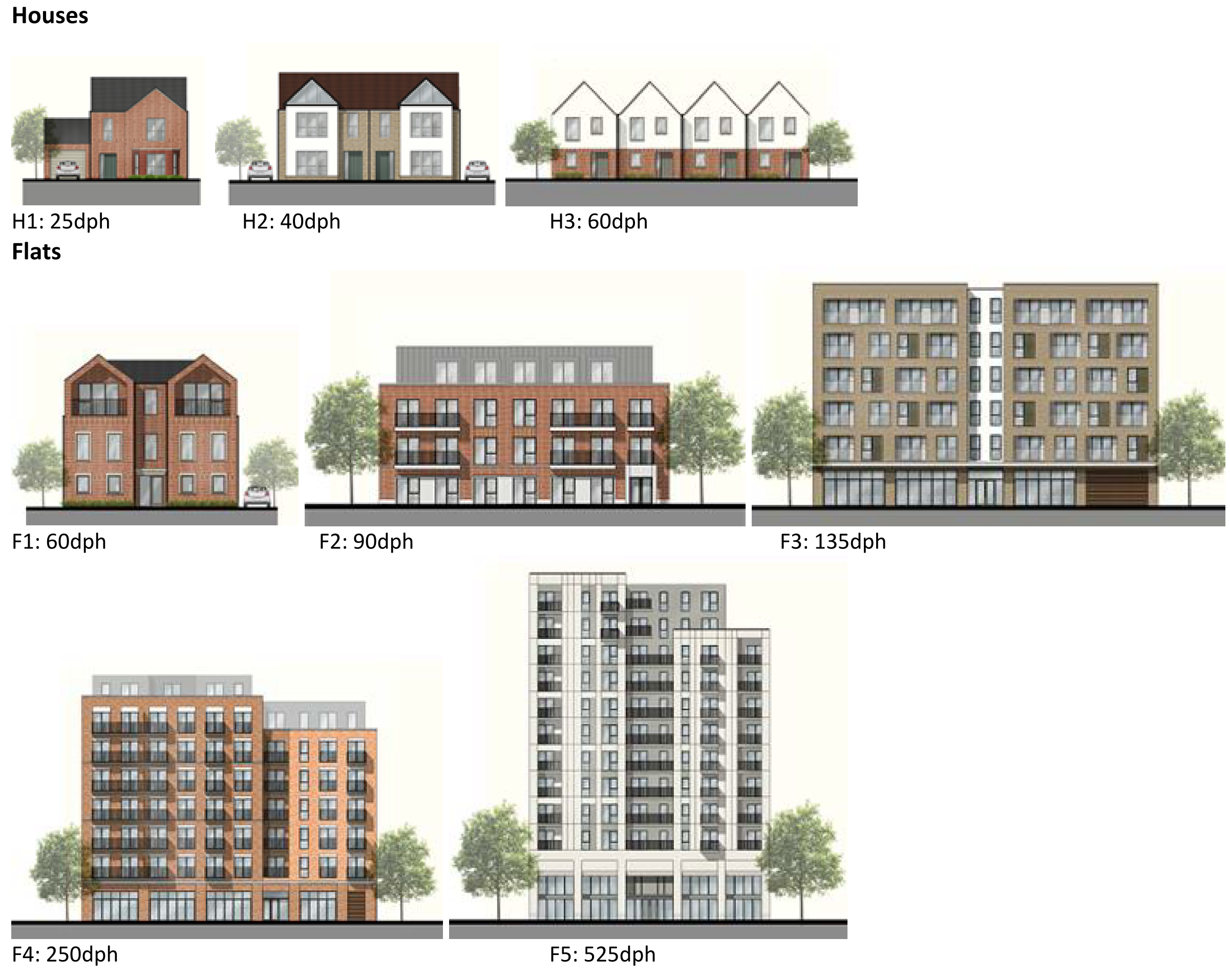 Map 27: Prittlewell Urban Forms
Question 3.3.4.2 Prittlewell (Urban Forms)
Have your say………
Please provide comment in support of your choice
a. What types of development typology (Figure 19) do you think should come in Prittlewell? You may wish to refer to the different urban forms presented in Map 27 in your answer.
To view our mapping feature showing Urban Forms: Southend-on-Sea Borough Council – Local Plan: Map 2 Urban Forms Map (opus4.co.uk)
3.3.4.3 Employment
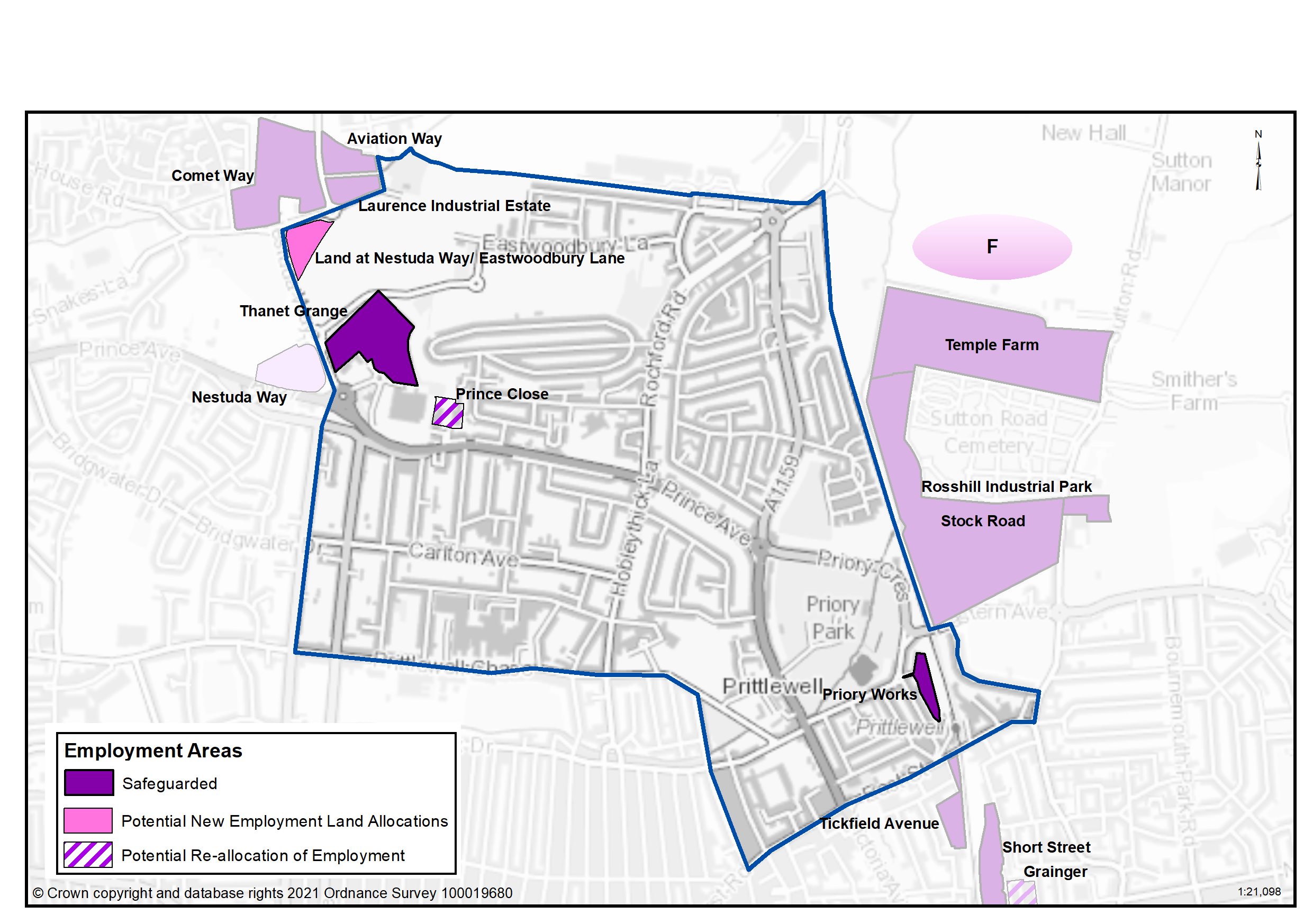
The retention and provision of employment sites is necessary to enable balanced job and housing growth. However, employment land has relatively lower land values compared to residential and therefore it is important to safeguard or allocate sites to facilitate present and future economic growth. Table 29 and Map 28 set out the Employment Areas in Prittlewell, where existing areas are proposed for retention, areas proposed for re-allocation, and additional areas proposed.
Table 29: Land Use Proposals in Prittlewell – Employment Land
|
Site Name |
Category |
Hectares |
Additional Floorspace |
|---|---|---|---|
|
Priory Works |
Local Employment Site |
0.96 |
|
|
Thanet Grange |
Local Employment Site |
5.41 |
|
|
Land at Nestuda Way/Eastwoodbury Lane |
Local Employment Site |
1.56 |
|
|
Prince Close |
Potential Re- allocation |
-0.9 |
|
|
Total |
7.03 |
|
|
Map 28: Proposed Employment Designations - Prittlewell
Question 3.3.4.3a Prittlewell (Employment)
Have your say………Please explain your answer
Question a - Do you agree that Priory Works should be safeguarded as a local employment site?
Question a - Do you agree that Thanet Grange should be safeguarded as a local employment site?
Question a - Do you agree with this proposed new employment allocation site for Land at Nestuda Way/ Eastwoodbury Lane?
Question a - Do you agree with the re-allocation of employment at Prince Close to residential led redevelopment?
Question 3.3.4.3b Prittlewell (Employment)
Have your say………Please explain your answer
Question b- Do you have any other comments on employment land provision in Prittlewell? If yes, please explain your answer.
3.3.4.4 Commercial Centres
To ensure the vitality of town centres, the National Planning Policy Framework encourages local planning authorities to implement planning policies and decisions that support the role that town centres play at the heart of local communities, by taking a positive approach to their growth, management, and adaptation.
The Government recently introduced changes to the Use Classes Order which consolidates a wide range of uses including retail, food, financial services, gyms, healthcare, nurseries, offices, and light industry into a single use class (Use Class E) and any change of use of a building or land between those uses falling within this Use Class will not require planning permission. It is therefore proposed to define as “Commercial Areas”, centres where we will promote ground floor uses to be within Class E Use Class and encourage improvements to shopfronts and the street scene.
There are a range of commercial centres in the Borough that protect ground floor uses for business purposes (use class E9) and thereby perform a vital function by ensuring communities are served by a range of retail and commercial services. The Commercial Centres in Prittlewell are shown in Map 29 and Table 30.
As of August 2021, the Government is also introducing expanded permitted development rights to enable Commercial Uses to be converted to residential without planning permission. Due to this there are limitations on safeguarding ground floor commercial uses within key centres from changing to residential. However, under Article 4 of the General Permitted Development Order a local planning authority can apply to the Secretary of State to withdraw specified permitted development rights across a defined area. The use of Article 4 directions should not be expansive and therefore if we were to use them to restrict ground floor commercial uses from changing to residential, we must focus them to the most important frontages. In reference to Map 29 and Table 30 we are interested in your views on which centres we should investigate for using Article 4 Directions in order to restrict ground floor commercial frontages from being developed to residential under permitted development.
Map 29: Prittlewell Commercial Centres
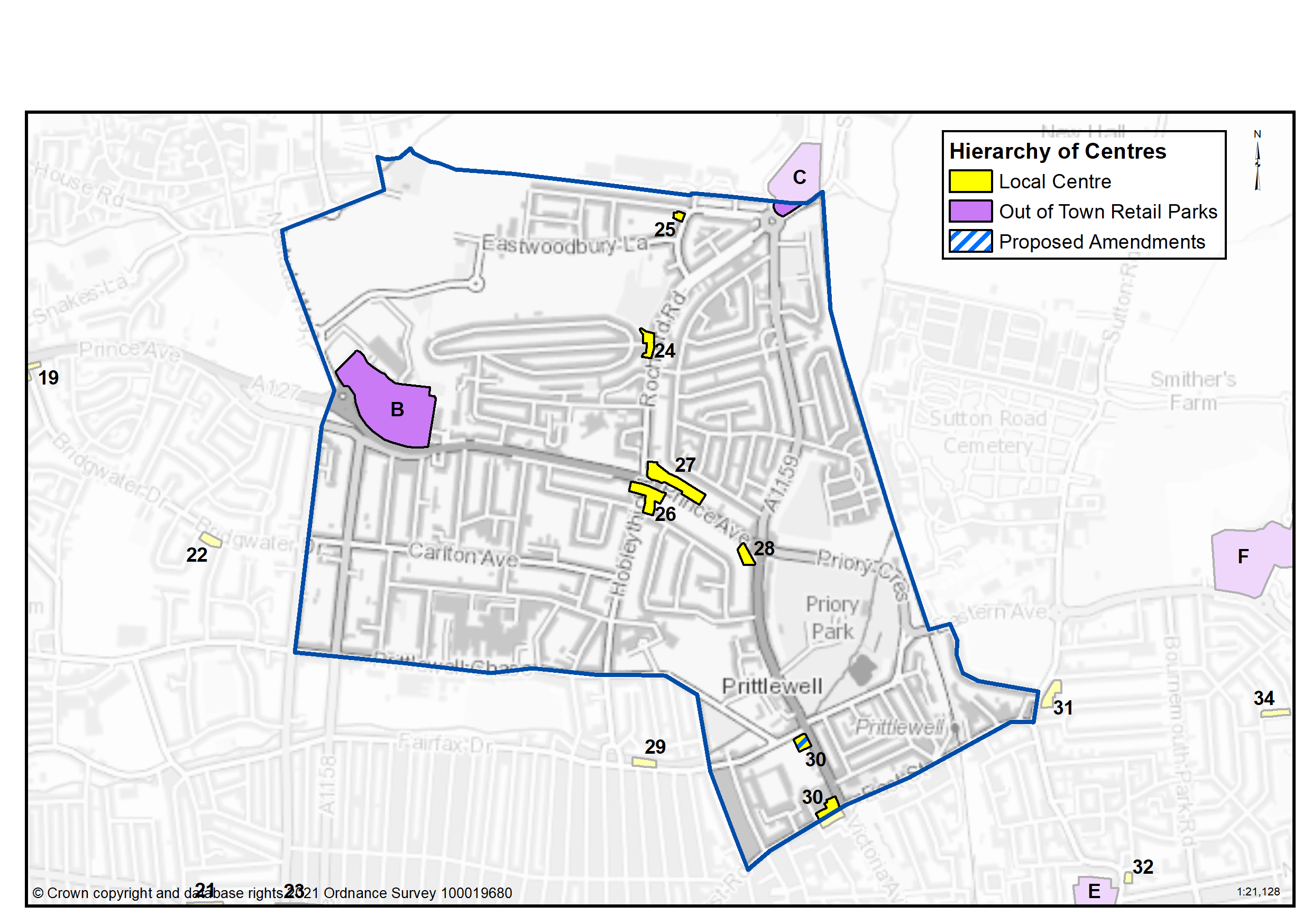
Table 30: Prittlewell Commercial Centres
| Ref | Name | Centre Type |
|---|---|---|
|
24 |
Rochford Road |
Local Centre |
|
25 |
Eastwoodbury Crescent |
Local Centre |
|
26 |
The Bell Prince Avenue |
Local Centre |
|
27 |
Hobleythick Lane /Prince Avenue |
Local Centre |
|
28 |
Earls Hall Parade (Cuckoo Corner) |
Local Centre |
|
30 |
Victoria Avenue/ West Street |
Local Centre |
|
B |
Thanet Grange/Tesco |
Out of Town Retail Parks |
|
C |
Airport Retail Park |
Out of Town Retail Parks |
There are amendments proposed to the Victoria Avenue/ West Street local centre due to the reduction of active frontages that reduce its ability to function as an effective commercial, business and service sector. The centre has a high vacancy rate, introducing a dispersed distribution of the retail provision. The proposed removal of its commercial centre designation will allow for a different policy approach, allowing for alternative uses, possibly as part of the wider regeneration of the Roots Hall site.
Question 3.3.4.4a Prittlewell (Commercial Centres)
Have your say…….
Please explain your answer
Question a - Should we seek to define Rochford Road as a Local Centre as set out in Table 30 to promote a range of commercial uses to serve local community needs and provide local employment opportunities?
Question a - Should we seek to define Eastwoodbury Crescent as a Local Centre as set out in Table 30 to promote a range of commercial uses to serve local community needs and provide local employment opportunities?
Question a - Should we seek to define The Bell Prince Avenue as a Local Centre as set out in Table 30 to promote a range of commercial uses to serve local community needs and provide local employment opportunities?
Question a - Should we seek to define Hobleythick Lane/Prince Avenue as Local Centre as set out in Table 30 to promote a range of commercial uses to serve local community needs and provide local employment opportunities?
Question a - Should we seek to define Earls Hall Parade (Cuckoo Corner) as a Local Centre as set out in Table 30 to promote a range of commercial uses to serve local community needs and provide local employment opportunities?
Question a - Should we seek to define Victoria Avenue/West Street as a Local Centre as set out in Table 30 to promote a range of commercial uses to serve local community needs and provide local employment opportunities?
Question a - Should we seek to define Thanet Grange/Tesco as an Out of Town Retail Park as set out in Table 30 to promote a range of commercial uses to serve local community needs and provide local employment opportunities?
Question a - Should we seek to define Airport Retail Park as an Out of Town Retail Park as set out in Table 30 to promote a range of commercial uses to serve local community needs and provide local employment opportunities?
Question 3.3.4.4b Prittlewell (Commercial Centres)
Question b. Should we investigate using Article 4 direction to safeguard ground floor commercial uses within the town, district and neighbourhood centres by restricting permitted development changes to residential – if so what frontages?
Question 3.3.4.4c Prittlewell (Commercial Centres)
Question c. Do you agree with the proposed amendments as set out on Map 29?
Question 3.3.4.4d Prittlewell (Commercial Centres)
Question d. Are there any other areas within the Prittlewell Neighbourhood area that we haven’t identified that should be promoted for commercial activities? If yes, please explain your answer and tell us where.
3.3.4.5 Green Space - Prittlewell
National planning policy allows for Local Plans to identify and protect existing green space so it is not built on unless an assessment demonstrates the open space, buildings or land are surplus to requirements; any open space lost would be replaced by equivalent or better provision in terms of quantity, quality and access; or the benefits of new sports and recreation facilities clearly outweigh the loss of the current or former use as open space. In this respect the New Local Plan seeks to protect the green spaces as set out in Table 31 and Map 30.
Existing Green Space
The main recreation resource for residents in Prittlewell are the two local parks at Priory Park and St Lawrence Park. The area also contains allotments and community growing space at Growing Together, and a number of playgrounds and smaller amenity open spaces. St Mary’s Churchyard also performs a role as green space within this urban area, providing a green link connecting Priory Park and Churchill Gardens. The residential area to the south west of Prittlewell is less provided for in terms of public open space, but the southern edge does benefit from the wide grassed boulevard of Prittlewell Chase which contains many mature trees. Tree canopy cover in the neighbourhood ranges from 10% of the ward in Prittlewell to 14.4% in St Laurence ward. This is set within the context of the Council’s Tree Policy which sets a target to extend the overall tree canopy cover in the Borough from 12% to 15% by 2050.
Local Green Space
National planning policy allows local authorities to designate land as Local Green Space through their local plans, so that communities can identify and protect green areas of particular importance to them, for example because of its historic significance, recreational value, tranquillity, beauty or richness of its wildlife. Policies for managing Local Green Space are consistent with those for Green Belts.
Proposed Local Green Space – Priory Park was gifted to the people of the town in 1917 by RA Jones. It contains the medieval Prittlewell Priory, now in use as a Museum, the Priory walled gardens, visitor centre, café, tennis and basketball courts, table tennis and chess, football pitches, children’s playground, fishing lake and areas of natural wetland. The park is of importance for heritage, nature conservation, sports and recreation, and as a green lung in a busy urban area close to an Air Quality Management Area and dual carriageway. It therefore holds special importance for local people and is proposed as a Local Green Space. The outcome of this consultation will be particularly important in demonstrating that the space is special to the community.
Proposed new green space
Two new pocket parks have been completed at Ecko Park, which connect the new housing development to Priory Park via a new pedestrian and cycle path. These are proposed for protection. Sidmouth Avenue playground has been recently improved with new equipment and is proposed for protection.
The entire length of the Prittle Brook (from Priory Park to Belfairs Woods) is an important corridor and waterway for wildlife, pedestrian and cycle route for recreation and active travel. It is therefore proposed to protect the route as a Green Corridor where its role will be protected and enhanced.
It is also proposed to designate the central verge along Prittlewell/Blenheim Chase from Fairfax Drive to Eastwood Road as a Linear Green Space, reflecting its important amenity and biodiversity value (Table 31a).
Map 30: Green Space - Prittlewell
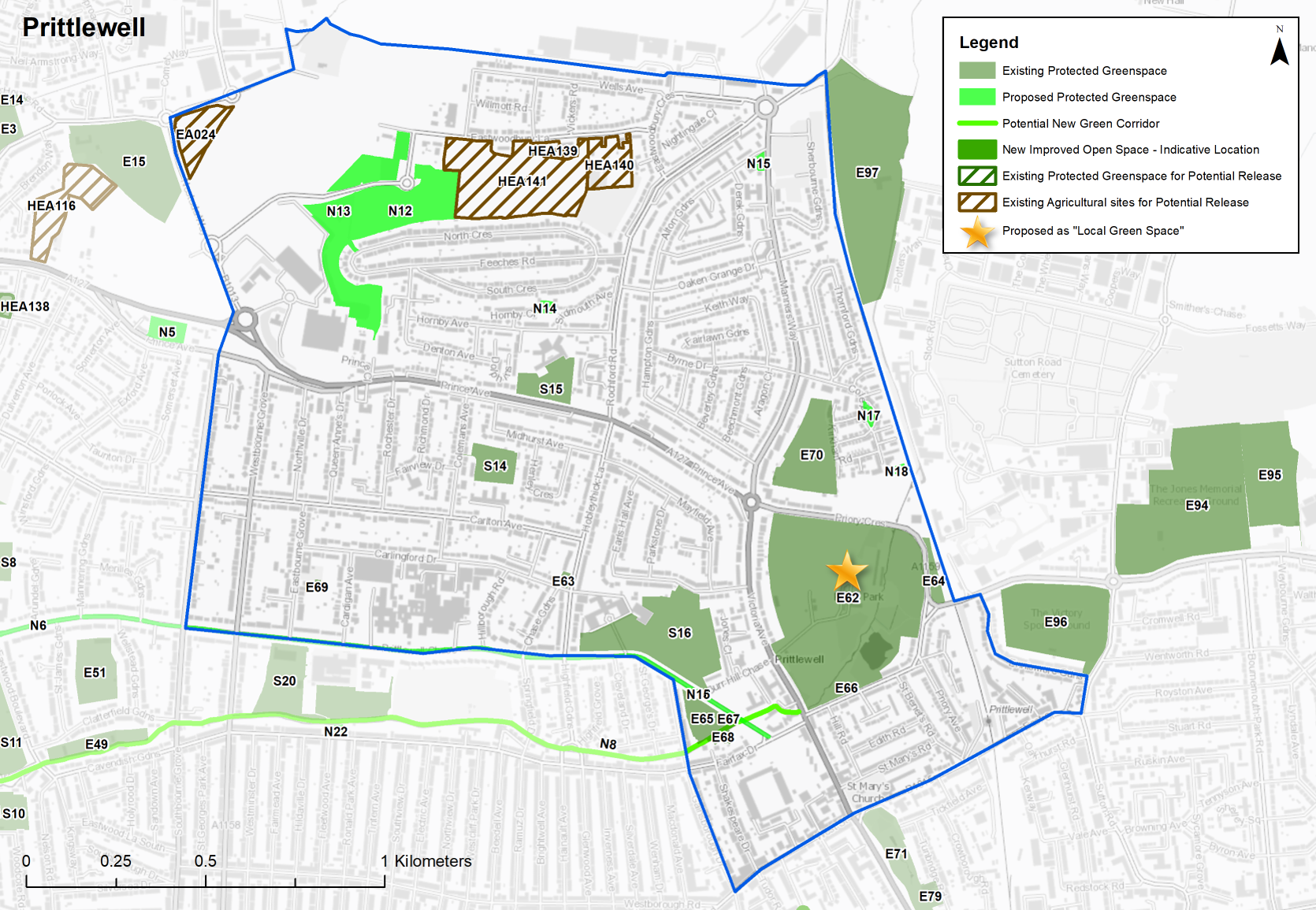
Table 31: Prittlewell – Protected Green Space
|
Site Ref. |
Name of Site |
Size (Ha) |
|
Site Ref. |
Name of Site |
Size (Ha) |
|---|---|---|---|---|---|---|
|
Local Park |
Sports Ground |
|||||
|
E62 |
Priory Park |
17.545 |
E69 |
Eastbourne Grove Tennis Court |
0.057 |
|
|
Amenity Open Space |
E70 |
Ecko Sports Ground East of Manners Way |
3.124 |
|||
|
E63 |
Hobleythick Lane Open Space |
0.108 |
School |
|||
|
E64 |
Prittlewell Prince Burial Ground - Priory Crescent |
0.416 |
S14 |
Earls Hall School Playing Fields |
1.143 |
|
|
E65 |
Gainsborough Park |
0.827 |
S15 |
Prince Ave School |
1.366 |
|
|
Playground |
S16 |
Southend High For Boys Playing Fields |
5.514 |
|||
|
E66 |
Priory Park Children's Play Area |
0.478 |
Allotments |
|||
|
E67 |
Gainsborough Park Playground |
0.189 |
A4 |
Rochford Road |
1.644 |
|
|
Community Growing Site |
A5 |
Manners Way |
1.932 |
|||
|
E68 |
Growing Together Trust |
0.234 |
A6 |
Growing Together |
0.303 |
|
|
|
Crematorium, Graveyard or Cemetry |
|||||
|
C3 |
St Laurence & All Saints |
1.451 |
||||
|
C4 |
St Mary’s Churchyard |
0.729 |
||||
Sites in bold are proposed as ‘Local Green Space’
Table 31a: Prittlewell – Proposed Green Space Allocations
Individual sites listed below with question
Question 3.3.4.5a Prittlewell (Green Space)
Have your say………
Please provide comment in support of your choice.
N12...St Laurence Park
Neighbourhood Park
Site Ref - N12
Name of Site - St Laurence Park
Size (Ha) - 8.228
Question a - Do you support the proposed new new green space designation at St Laurence Park? If not, can you explain why?
N13...St Laurence Park Childrens Play Area
Playground
Site Ref - N13
Name of Site - St Laurence Park Childrens Play Area
Size (Ha) - 0.182
Question a - Do you support the proposed new new green space designation at St Laurence Park Childrens Play Area? If not, can you explain why?
N14...Sidmouth Avenue Playground
Playground
Site Ref - N14
Name of Site - Sidmouth Avenue Playground
Size (Ha) - 0.148
Question a - Do you support the proposed new new green space designation at Sidmouth Avenue Playground? If not, can you explain why?
N15...Manners Way Playground
Playground
Site Ref - N15
Name of Site - Manners Way Playground
Size (Ha) - 0.131
Question a - Do you support the proposed new new green space designation at Manners Way Playground? If not, can you explain why?
N16...Prittlewell Chase
Linear Green Space
Site Ref - N16
Name of Site - Prittlewell Chase
Size (Ha) - 1.735
Question a - Do you support the proposed new new green space designation at Prittlewell Chase? If not, can you explain why?
N17...Ecko Park North
Pocket Park
Site Ref - N17
Name of Site - Ecko Park North
Size (Ha) - 0.146
Question a - Do you support the proposed new new green space designation at Ecko Park North? If not, can you explain why?
N18...Ecko Park South
Pocket Park
Site Ref - N18
Name of Site - Ecko Park South
Size (Ha) - 0.119
Question a - Do you support the proposed new new green space designation at Ecko Park South? If not, can you explain why?
N8... Prittlebrook
Local Park
Site Ref - N8
Name of Site - Prittle Brook
Size (Ha) - 4.225
Question a - Do you support the proposed new new green space designation at Prittle Brook? If not, can you explain why?
Table 31b: Land Use Proposals in Prittlewell – Green Space Currently Protected but with potential for release
Question 3.3.4.5b Prittlewell (Green Space)
HEA139 Land to south of Eastwoodbury Lane
Site (Ha) - 0.209
Description - Smallholdings/ green space
Quality/ condition - High grade agricultural land, no public access. Part of site identified in Airport Joint Area Action Plan as designated public open space but not yet implemented.
Area of Deficiency (Y/N) - N
Potential Housing Capacity 10
Justification - Land is in public ownership and underutilised, with potential for residential development.
Question b - Do you agree with the green space sites / agricultural land identified as having the potential to be released for development (Table 31b)? If yes, please explain your answer with reference to relevant site/s in Table 31b.
HEA140 Land to south of Eastwoodbury Lane
Site (Ha) - 1.625
Description - Smallholdings/ green space
Quality/ condition - High grade agricultural land, no public access. Part of site identified in Airport Joint Area Action Plan as designated public open space but not yet implemented.
Area of Deficiency (Y/N) - N
Potential Housing Capacity 81
Justification - Land is in public ownership and underutilised, with potential for residential development.
Question b - Do you agree with the green space sites / agricultural land identified as having the potential to be released for development (Table 31b)? If yes, please explain your answer with reference to relevant site/s in Table 31b.
HEA141 Land to south of Eastwoodbury Lane
Site (Ha) - 7.17
Description - Smallholdings/ green space
Quality/ condition - Approximately 50% of site is high grade agricultural land and rest smallholdings, no public access.
Area of Deficiency (Y/N) - N
Potential Housing Capacity 180
Justification - Land is in public ownership and underutilised, with potential for residential development.
Question b - Do you agree with the green space sites / agricultural land identified as having the potential to be released for development (Table 31b)? If yes, please explain your answer with reference to relevant site/s in Table 31b.
Question 3.3.4.5c Prittlewell (Green Space)
Question c Do you agree with Priory Park being proposed as Local Green Space? If not, can you explain why?
Question 3.3.4.5d Prittlewell (Green Space)
Question d - Do you propose any other sites should be designated as Local Green Space? If yes, please provide an address and supporting evidence that outlines how the space is special to the local community in terms of beauty, historic significance, recreational value, tranquillity, wildlife or for other reasons.
Question 3.3.4.5e Prittlewell (Green Space)
Question e - Do you have any other comments regarding green space in Prittlewell? If yes, please explain your answer.
*nurseries, primary schools, secondary schools, doctors, dentists, pharmacies, libraries, places of worship, public conveniences, community centres and halls, playing pitches, local equipped play space, amenity greenspace, allotments, natural and semi-natural greenspace, local and neighbourhood centres, town and district centres