3.5.1 General Character
Westcliff neighbourhood lies between Leigh to the west and Southend Town Centre and Central Seafront to the east (Map 37, Figure 23). It stretches from the coast to the south to the Prittle Brook to the north and is bisected by the London Road (A13). The London Road marks a change in street pattern and defines the distinctive Westborough residential area in the northern part of the neighbourhood, a tightly knit grid pattern of terraced Victorian and Edwardian housing. The southern part of the neighbourhood contains a mixture of mainly Victorian and Edwardian residential streets with some larger properties particularly along the seafront route, including high rise flats.
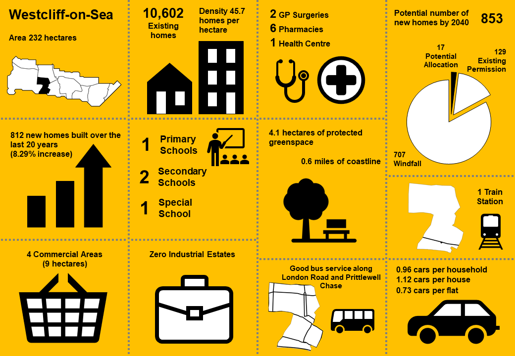
Westcliff is the most densely developed neighbourhood in the Borough, having developed largely during the Victorian and Edwardian eras. Many properties have in the past been sub-divided into flats and average density in the area is around 46 homes per hectare. In places this has resulted in a lack of amenity space, including space for adequate and convenient waste storage.
The commercial and retail areas of the neighbourhood are centred along the A13 London Road and the adjacent district centre of Hamlet Court Road with its north-south axis. To the south of this commercial area is Westcliff Railway station, providing connections to Southend and London. Prittlewell Railway Station lies to the east of the neighbourhood and is in reasonable walking distance for many residents. The area benefits from regular bus services along the A13 London Road and Prittlewell Chase to the north, providing services to Southend Hospital, Southend, Eastwood, Leigh and Shoeburyness. However, bus services to some parts of the Borough are infrequent and often involve changes.
Key issues in the area include development pressure to convert family housing to flats, and associated impacts on residential amenity including on street parking pressure, and high-rise development along the seafront, the scale and massing of which can have an impact on the character of the area.
Westcliff has the second lowest car ownership in the Borough, although there is still demand for on-street car parking spaces given the high number of conversions from houses to flats or houses in multiple occupation, and lack of off-street parking in many of the Victorian and Edwardian properties.
Map 37: Westcliff Characteristics
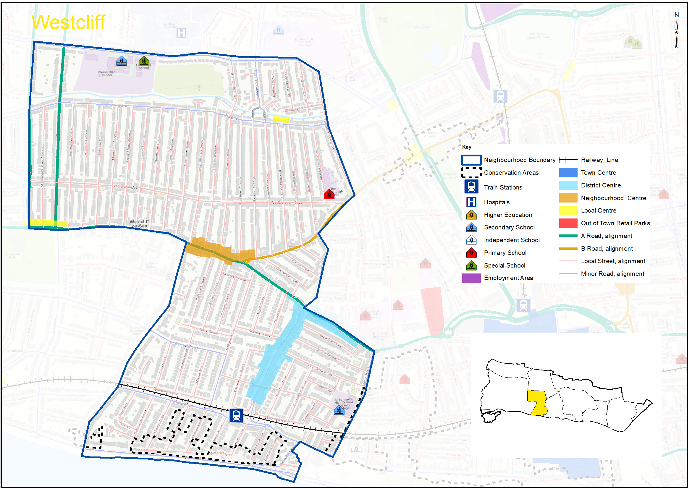
Figure 23: Westcliff Characteristics
|
No. Homes |
10,602 |
Land Area (ha) |
232 |
|
Density |
45.7 dph |
Car Ownership |
0.96 |
3.5.2 Vision – Westcliff
Where we want to be
Westcliff will continue to be a vibrant and accessible neighbourhood, with every day goods and services within easy reach for residents. Hamlet Court Road District Centre remains the focus for everyday activity, complemented by businesses along the A13 London Road, and its community and cultural assets will be strengthened. A draft set of priorities for Westcliff are set out below to aid feedback:
- Focus day to day shops and services in Hamlet Court Road district centre including opportunities for co-working combined with commercial premises.
- Opportunities for new homes focussed along London Road public transport corridor and near train stations.
- Identify opportunities for new and improved green spaces and increased tree cover throughout the area, particularly around Hamlet Court Road/London Road.
- Conserve and enhance designated heritage assets.
- Strengthen local walking and cycling networks, including links to railway stations and centres, with improved wayfinding and public art, and seek opportunities to expand the Borough’s Electric Vehicle charging infrastructure network.
- Carefully manage environmental assets and flood risk, including the foreshore and Prittle Brook.
Question 3.5.2 Westcliff (Vision)
Have your say………
Please explain your answers
a. Do you agree with our draft vision and priorities for Westcliff? If not, let us know what we have missed.
3.5.3 Complete Neighbourhoods (accessibility to services and facilities)
The following profile seeks to build up a picture of the ‘completeness’ of Westcliff neighbourhood. Completeness is based on mapping the walking catchments around different day to day facilities (17 different facilities in total). The catchment areas vary by facility and reflect comfortable walking distances for the average, able-bodied person. The catchments are based on actual walking routes rather than ‘as the crow flies’ distances.
A high completeness score means a place has lots of facilities the community needs within an easy walking distance. This approach recognises the important links to health and social well-being, community cohesion and inclusion.
The completeness score for Westcliff, by infrastructure type, is summarised in the rainbow image below. For example 84% of the neighbourhood lies within easy walking distance to a health facility, 69% of the neighbourhood is within easy walking distance of sports and leisure facilities, while 18% is within an easy walk of green space.
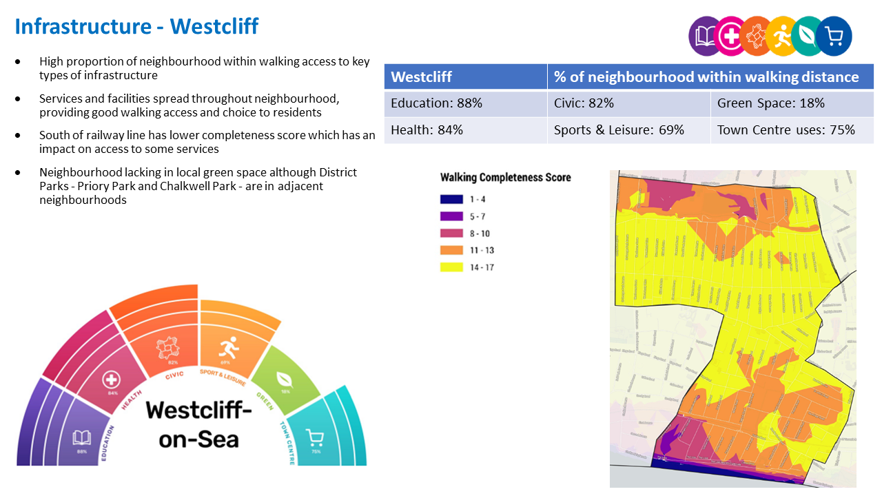
Westcliff ‘Aggregated Completeness Score’ = 70
Map – as an example a high completeness score would be 14 –17 different facilities being within a reasonable walking distance from home. Conversely a low score would be less than 4 facilities within walking distance.
Question 3.5.3 Westcliff (Infrastructure)
Have your say…….
Please explain your answer
a. Are there any issues with infrastructure provision in Westcliff? Please explain your answer and let us know what the priorities should be over the next 20 years.
3.5.4 Land Use Proposals – Westcliff
A number of potential land use proposals are identified for future housing, employment and open space. For each site, the location, proposed use and indicative amount of development (if applicable) is provided.
3.5.4.1 New Homes
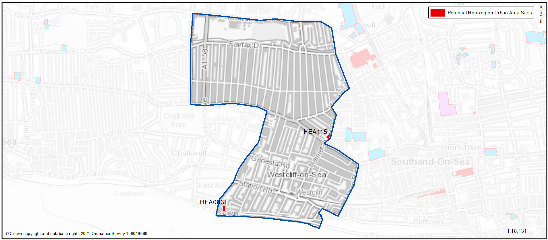
Potential site proposals for residential development can be viewed in Map 38. Table 38 sets outs relevant information including, context and surrounding uses, proposed use, estimated number of new dwellings and what ‘component of growth’ the site contributes to in reference to Section 2: Meeting Our Housing Needs (Table 2). The sites have been promoted to us by landowners/ agents and are included here for comment. Table 38 also notes the amount of new homes that are likely to come forward over the lifetime of the plan through sites already with planning permission and windfall development.
Map 38: Potential Residential Sites – Westcliff (excluding those with planning permission)
For more information on each site an assessment can be viewed by clicking on the link reference in Table 38 below or via: Appendix 4: Site Proformas | Southend Local Plan
Table 38: Potential Residential Sites - Westcliff
Individual Potential Sites listed below
Question 3.5.41a Westcliff (Residential)
HEA083...30-32 The Leas
HEA083
Context and Surrounding uses - The site previously contained 3 historic dwellings but following 2 fires in 2018 planning consent was granted to demolish the buildings due to health and safety concerns and this has been completed.
Potential Land Use - Subject to an assessment of the impact of any development on the character and appearance of the Crowstone Conservation Area, which the site lies within. Potential for residential conversion / development. Planning permission granted in 2020 for 9 residential units.
Potential Land Use (Summary) - Residential development
Component of Change - Urban Area General
Estimated number of homes - Gross 7 Net 7
| https://localplan.southend.gov.uk/sites/localplan.southend/files/2021-08/Westcliff%20Proformas.pdf#page=1 |
Question a - Do you agree with the potential proposals for this site? Please explain your answer. You may wish to outline the type and scale of development you would like to see come forward in reference to Figure 24: Development Typologies
Question 3.5.41a Westcliff (Residential)
HEA115...Part of Hamlet Court Road Car Park
HEA115
Context and Surrounding uses - Eastern half of the Hamlet Court Road car park (surface car park), residential properties to the north east, car park and public toilets to the south west. Surrounded by two storey residential buildings. District Centre of Hamlet Court Road to the south.
Potential Land Use - Subject to the consideration of loss of public parking the site is considered suitable in principle for housing development and would also benefit from some form of public green space.
Potential Land Use (Summary) - Residential development
Component of Change - Urban Area General
Estimated number of homes - Gross 10 Net 10
| https://localplan.southend.gov.uk/sites/localplan.southend/files/2021-08/Westcliff%20Proformas.pdf#page=2 |
Question a - Do you agree with the potential proposals for this site? Please explain your answer. You may wish to outline the type and scale of development you would like to see come forward in reference to Figure 24: Development Typologies
Question 3.5.41b Westcliff (Residential)
Please explain your answer
b. Do you have any other comments on housing provision in Westcliff? If yes, please explain your answer.
3.5.5 Urban Form and Development Typologies
Good quality urban design will be essential in new housing development if the character of the neighbourhood is to be enhanced.
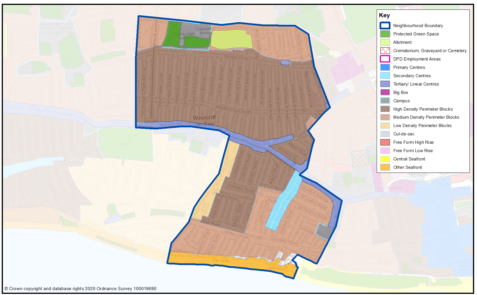
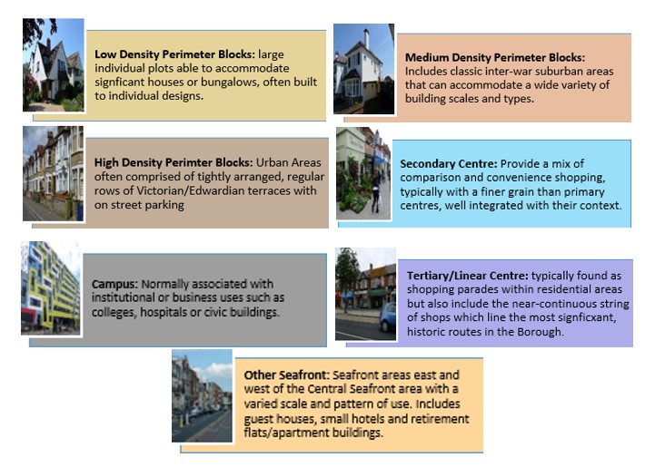
Map 39 shows the Urban Forms of Westcliff neighbourhood. This has been informed by the Southend Borough Wide Character Study and is intended to provide a broad overview of the types and densities of development across the neighbourhood; this can range from low density, areas of detached housing, to high rise flats.
To assist with the preparation of development management and design policies, which will impact the scale, type and density of new homes, we are interested in your views on broadly what types of development you think should come forward in the neighbourhood. It may be that there are different parts of the neighbourhood that you think could accommodate different types of development.
Figure 24 provides a range of development typologies at different densities, for both houses and flats. We’d like to know whether there is a particular
typology that you’d like to see come forward in Westcliff and within the different Urban Forms as shown in Map 39. For instance you may believe the
‘Linear Centre’ of the London Road within Map 39 should accommodate higher density development, such as flats typology F2 and F3, within Figure 24.
Figure 24 – Development Typologies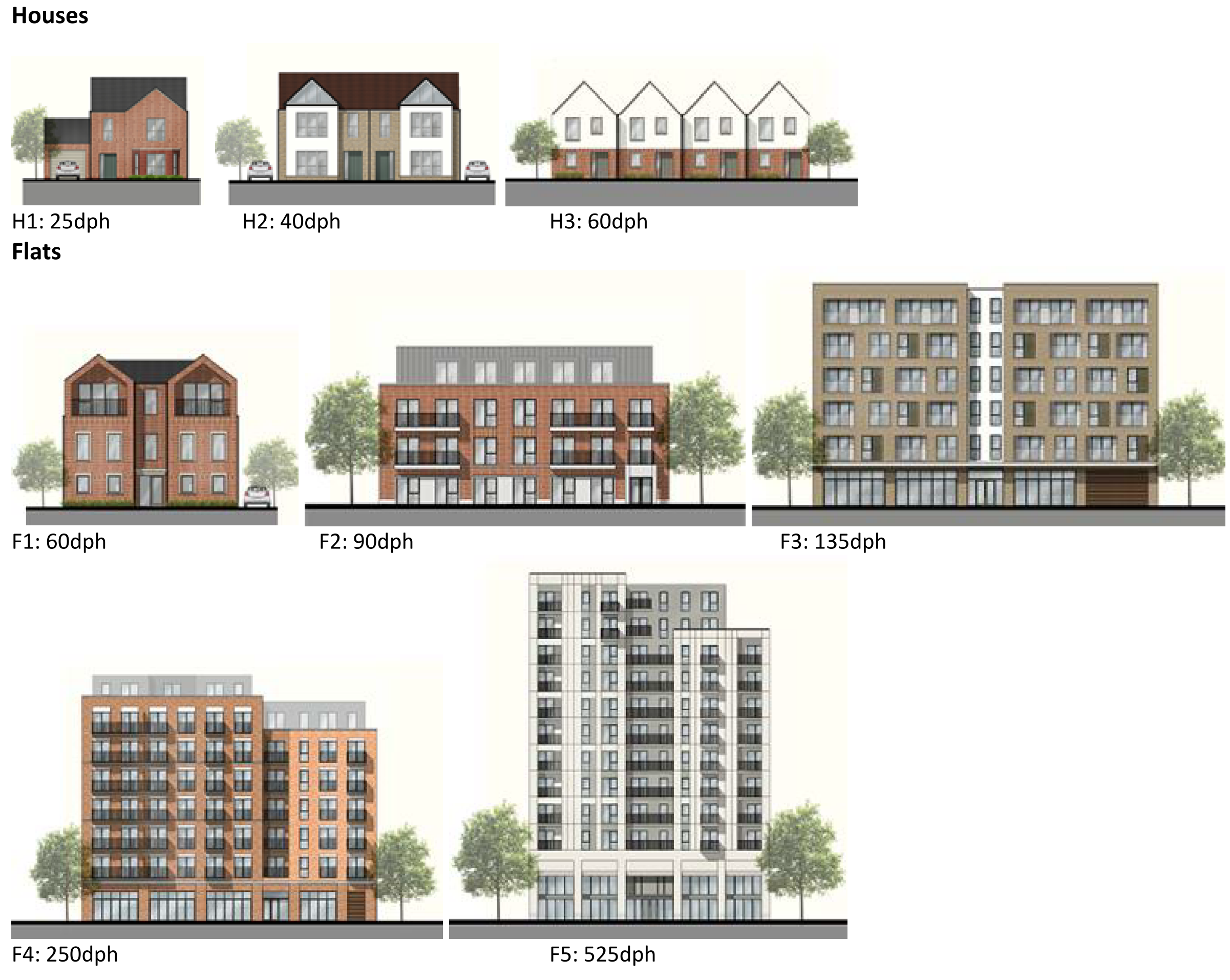
Map 39: Urban Form of Westcliff
Question 3.5.5 Westcliff (Urban Form)
Have your say…….
Please explain your answer
a. Are there development typologies (Figure 24) that you would like to see come forward in Westcliff? Please explain your answer - you may wish to refer to the different urban forms presented in Map 39 in your response.
To view our mapping feature showing Urban Forms: Southend-on-Sea Borough Council – Local Plan: Map 2 Urban Forms Map (opus4.co.uk)
3.5.6 Employment
The retention and provision of employment sites is necessary to enable balanced job and housing growth. Westcliff neighbourhood has no designated employment areas. Key employers in the area are Southend Hospital, local schools and the two theatres, as well as the many small businesses within Hamlet Court Road and along London Road. Proximity to Westcliff and Prittlewell stations also provides opportunity for residents travel out of the Borough for work.
3.5.7 Commercial Centres
To ensure the vitality of town centres, the National Planning Policy Framework encourages local planning authorities to implement planning policies and decisions that support the role that town centres play at the heart of local communities, by taking a positive approach to their growth, management, and adaptation.
The Government recently introduced changes to the Use Classes Order which consolidates a wide range of uses including retail, food, financial services, gyms, healthcare, nurseries, offices, and light industry into a single use class (Use Class E) and any change of use of a building or land between those uses falling within this Use Class will not require planning permission. It is therefore proposed to define as “Commercial Areas”, centres where we will promote ground floor uses to be within Class E Use Class and encourage improvements to shopfronts and the street scene.
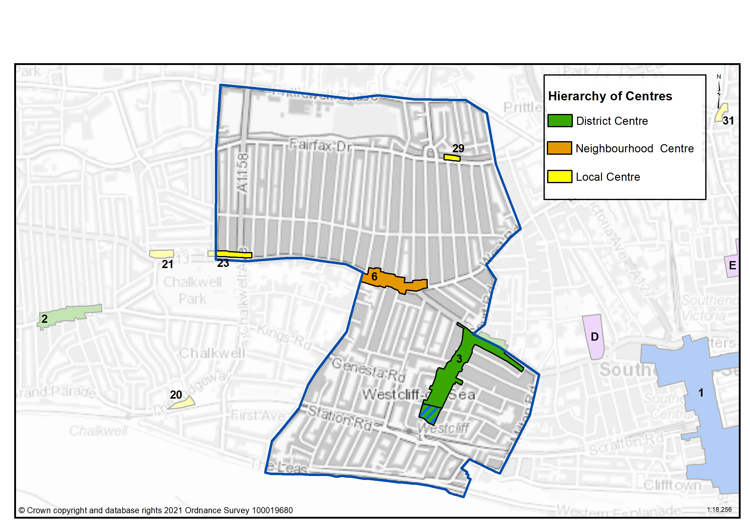
There are a range of commercial centres in the Borough that protect ground floor uses for business purposes (use class E8) and thereby perform a vital function by ensuring communities are served by a range of retail and commercial services. The Commercial Centres in Westcliff are set out in Table 39.
There are amendments proposed to the Westcliff (Hamlet Court Road/London Road) District Centre (Map 40) due to the reduction of active frontages in the south of the centre that reduce its ability to function as an effective commercial, business and service sector. The southern section has a high proportion of units in residential use, introducing a dispersed distribution of the retail provision. To ensure a healthy commercial centre which delivers the required improvements and which functions accordingly it might be necessary to consider the extent of the centre. Releasing this part of the centre by allowing for alternative uses, while the rest of the centre can be the focus for commercial uses, will consolidate and strengthen the whole centre.
As of August 2021, the Government is also introducing expanded permitted development rights to enable Commercial Uses to be converted to residential without planning permission. Due to this there are limitations on safeguarding ground floor commercial uses within key centres from changing to residential. However, under Article 4 of the General Permitted Development Order a local planning authority can apply to the Secretary of State to withdraw specified permitted development rights across a defined area. The use of Article 4 directions should not be expansive and therefore if we were to use them to restrict ground floor commercial uses from changing to residential, we must focus them to the most important frontages. In reference to Table 39 and Map 40 we are interested in your views on which centres we should investigate for using Article 4 Directions in order to restrict ground floor commercial frontages from being developed to residential under permitted development.
Table 39: Westcliff Commercial Centres
|
Ref |
Name |
Centre Type |
|---|---|---|
|
3 |
Westcliff (Hamlet Court Road/London Road) |
District Centre |
|
6 |
London Road / West Road |
Neighbourhood Centre |
|
23 |
London Road, Chalkwell Park |
Local Centre |
|
29 |
Fairfax Drive |
Local Centre |
Map 40: Westcliff Commercial Centres
Question 3.5.6a Westcliff (Commercial Centres)
Have your say…….
Please explain your answer
a. Should we seek to define Westcliff (Hamlet Court Road/London Road) as a District Centre as set out in Table 39 to promote a range of commercial uses to serve local community needs and provide local employment opportunities?
a. Should we seek to define London Road/West Road as a Neighbourhood Centre as set out in Table 39 to promote a range of commercial uses to serve local community needs and provide local employment opportunities?
a. Should we seek to define London Road, Chalkwell Park as a Local Centre as set out in Table 39 to promote a range of commercial uses to serve local community needs and provide local employment opportunities?
a. Should we seek to define Fairfax Drive as a Local Centre as set out in Table 39 to promote a range of commercial uses to serve local community needs and provide local employment opportunities?
Question 3.5.6b Westcliff (Commercial Centres)
b. Should we investigate using Article 4 direction to safeguard ground floor commercial uses within the town, district and neighbourhood centres by restricting permitted development changes to residential – if so what frontages?
Question 3.5.6c Westcliff (Commercial Centres)
c. Do you agree with the proposed amendments as set out on Map 40?
Question 3.5.6d Westcliff (Commercial Centres)
d. Are there any other areas within the Westcliff Neighbourhood area that we haven’t identified that should be promoted for commercial activities? If yes, please explain your answer and let us know where.
3.5.8 Green Space
National planning policy allows for Local Plans to identify and protect existing green space so it is not built on unless an assessment demonstrates the open space, buildings or land are surplus to requirements; any open space lost would be replaced by equivalent or better provision in terms of quantity, quality and access; or the benefits of new sports and recreation facilities clearly outweigh the loss of the current or former use as open space. In this respect the New Local Plan seeks to protect the green spaces as set out in Table 40 and Map 41.
Existing Green Space
The neighbourhood itself has very little public green space. There is a playground at Fairfax Drive and allotments at Springfield Drive. Just outside the neighbourhood, Milton Gardens and Gainsborough Park and playground, although relatively small, are also well used by residents. There are large public parks at Priory Park, Chalkwell Park and Esplanade Gardens, to the east, west and south of the neighbourhood area, which also offer access to green space for residents. However the high-density nature of the neighbourhood and more urbanised character of the streets mean that it is less leafy in character than most of the other neighbourhoods. This is illustrated by the lack of tree cover, which at 8.5% of the neighbourhood is one of the lowest in the Borough. The Council’s Tree Policy sets a target to extend the overall tree canopy cover in the Borough from 12% to 15% by 2050. Tree cover should be increased whenever opportunities arise.
Residents in the western and eastern edges of Westcliff are within the walking catchment of Chalkwell Park and Priory Park, offering a range of facilities
including cafes, cricket and bowling, football pitches and other sports facilities, and children’s playgrounds. The south east corner of the neighbourhood is within walking distance of Milton Gardens and Esplanade Gardens. Nevertheless, there remains an area in the centre of Westcliff around West Road and the top of Hamlet Court Road that lies outside a comfortable walking distance of any open space facility. This area, which has one of the highest population densities in the Borough and is near to several primary schools is therefore a priority location for new local play space or pocket parks.
Local Green Space
National planning policy allows local authorities to designate land as Local Green Space through their local plans, so that communities can identify and protect green areas of particular importance to them, for example because of its historic significance, recreational value, tranquillity, beauty or richness of its wildlife. Policies for managing Local Green Space are consistent with those for Green Belts. No Local Green Space sites are proposed in Westcliff. The outcome of this consultation will be particularly important in demonstrating whether any green spaces should have this designation.
Proposed New Green Space Sites (Table 40a)
It is proposed to designate a site at the junction of London Road and Crowstone Avenue which is already landscaped and provided with seating and bins, as a Pocket Park.
Landscaped areas at The Leas are proposed to be protected as Linear Green Space as they are not currently protected. For the same reason Fairfax playground is also proposed to be protected.
The Victory Path from the Ridgeway to Crowstone Road and the Prittle Brook are proposed to be designated as Green Corridors, where biodiversity will be protected and enhanced and the route promoted for walking and cycling.
An area of search has also been identified at Hamlet Court Rd/London Road, where new provision for pocket parks or local play space should be prioritised as part of any redevelopment proposals.
Map 41: Existing Green Space in Westcliff and Proposed New Green Space
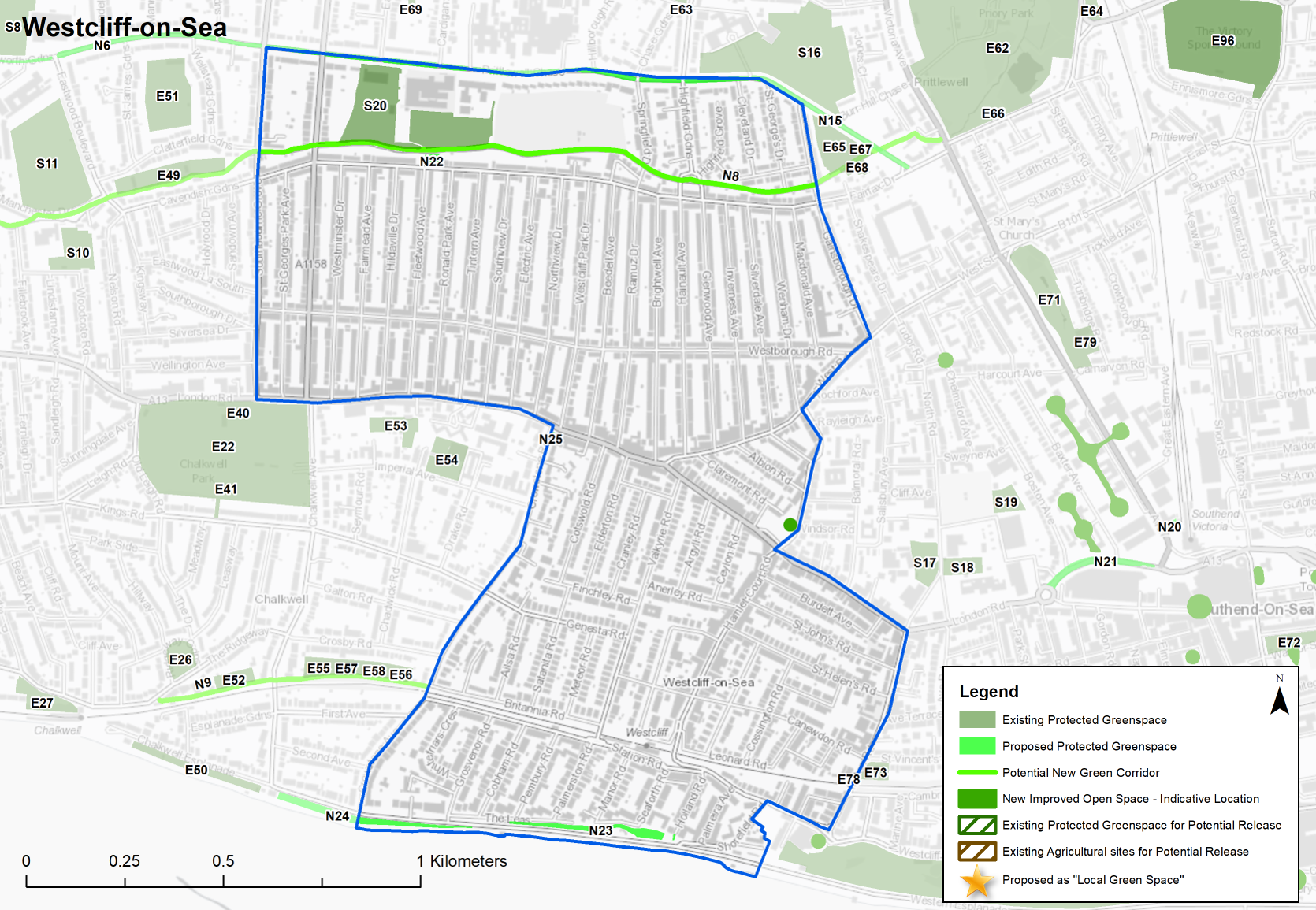
Table 40: Westcliff – Protected Green Space
|
Site Ref. |
Name of Site |
Size (Ha) |
|
Site Ref. |
Name of Site |
Size (Ha) |
|---|---|---|---|---|---|---|
|
School |
Allotments |
|||||
|
S20 |
Chase High |
4.052 |
A7 |
Westcliff (Springfield Drive) Allotment |
4.582 |
|
Table 40a: Westcliff – Proposed New Green Space Designations
Individual sites listed below with question
Question 3.5.8a (Westcliff Green Space)
Have your say…….
Please explain your answer
N22...Fairfax Playground
Linear Green Space
Site Ref - N22
Name of Site - Fairfax Playground
Size (Ha) - 0.106
Question a - Should we seek to protect this green space which is not currently protected?
N23..The Leas (East)
Linear Green Space
Site Ref - N23
Name of Site - The Leas (East)
Size (Ha) - 0.513
Question a - Should we seek to protect this green space which is not currently protected?
N24...The Leas (South)
Linear Green Space
Site Ref - N24
Name of Site - The Leas (South)
Size (Ha) - 0.671
Question a - Should we seek to protect this green space which is not currently protected?
N25...Crowstone Road
Pocket Park
Site Ref - N25
Name of Site - Crowstone Road
Size (Ha) - 0.025
Question a - Should we seek to protect this green space which is not currently protected?
N8... Prittle Brook
Green Corridor
Site Ref - N8
Name of Site - Prittle Brook
Size (Ha) - 4.225
Question a - Should we seek to protect this green space which is not currently protected?
Question 3.5.8b (Westcliff Green Space)
b. Do you agree that the area identified on Map 41 as an area of search should be promoted for additional tree planting, soft landscaping or children’s play space where opportunities arise through new development?
Question 3.5.8c (Westcliff Green Space)
c. Are there any other areas we haven’t identified that should be protected or promoted for green infrastructure? Please provide an address.
Question 3.5.8d (Westcliff Green Space)
d. Are there any sites within Westcliff that should be designated as Local Green Space? If yes, please provide an address and supporting evidence, for example the space is special in terms of beauty, historic significance, recreational value, tranquillity, wildlife or is special to the local community for other reasons.
e. Do you have any other comments on green space provision in Westcliff? If yes, please explain your answer.