3.6.1 General Character
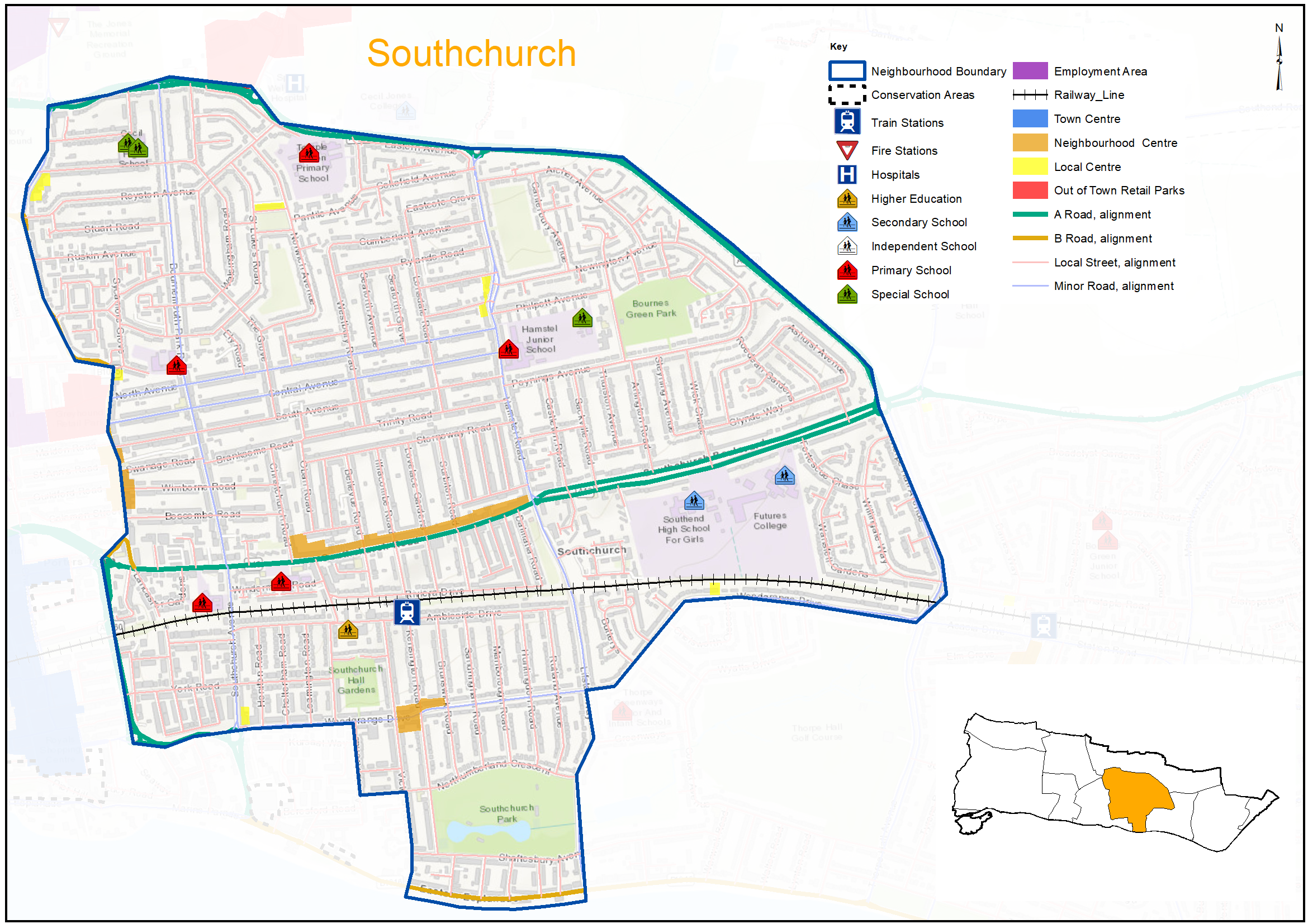
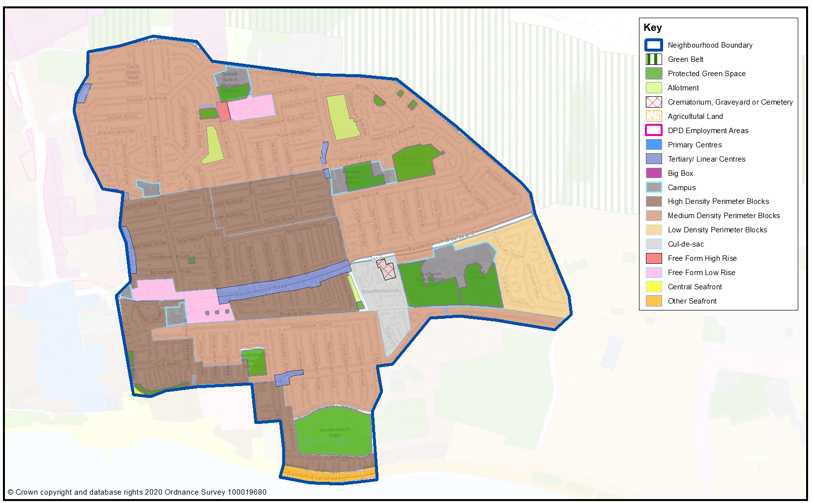
Southchurch is a mainly residential area lying to the east of the town centre (Map 42, Figure 26). At its heart is the Southchurch Road neighbourhood centre which provides a range of shopping, commercial and community uses. Southend East railway station lies to the south of the local centre and regular bus services are focussed along Southchurch Road.
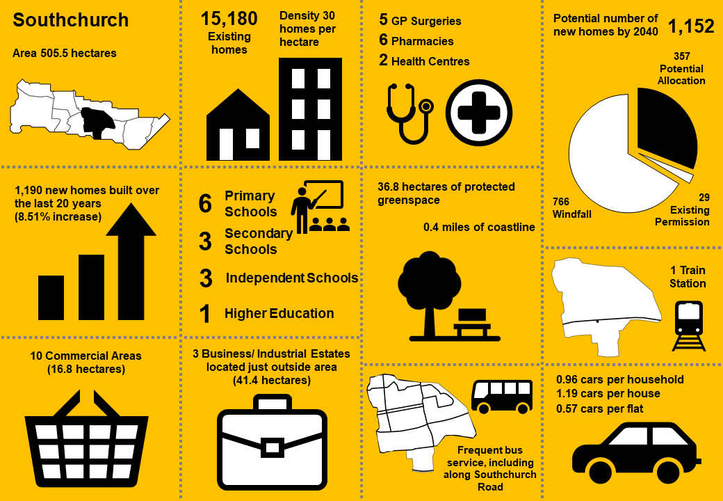
The residential streets spanning out from the centre provide for traditional Victorian/Edwardian housing of tightly knit terraced houses and flats/maisonettes on a grid street pattern. Housing types in the northern part of the neighbourhood are less distinctive comprising mainly inter-war housing including some public sector housing. There are approximately 10,800 homes within Southchurch with a density of 30 homes per hectare.
Lower density post war housing is provided to the east and south of the neighbourhood. To the east a mix of detached housing and bungalows is set within more generous plots focussed around Southchurch Boulevard, which provides a green lung running from the local centre into the neighbouring Thorpe Bay Neighbourhood. To the south mainly semi-detached housing is focussed around Woodgrange Drive neighbourhood centre containing a number of shopping and community uses, and Southchurch Hall Gardens and Southchurch Park which provide for a range of formal and informal recreation and leisure uses.
On the northern edge of the neighbourhood are a range of commercial and leisure uses. These include the Jones Memorial Recreation Ground, the Fossetts Way Retail Park, a number of employment estates centred around Stock Road, the Wellesley Hospital (private), Cecil Jones Academy and the Garon Park Sports Complex, which contains a range of indoor and outdoor sport and leisure facilities.
Bournes Green Park and children’s play area in the north east of the neighbourhood, provides an additional area of open space, and there is a children’s play area and allotments to the west of Lifstan Way. Cluny Square also provides an area of green space, with Cluny Garden (community garden, allotments) to the south.
Issues facing the area include parking stress in the more tightly planned residential areas due to the lack of off street parking facilities and the demand for on street parking from the Southchurch Road neighbourhood centre. On average there are 0.96 cars per household (1.19 per houses and 0.57 per flat)2
Map 42: Southchurch Characteristics
3.6.2 Vision - Southchurch
Where we want to be
Southchurch will continue to be an important residential area offering a diverse range of housing types to serve local needs set within a ‘green’ environment. The Southchurch Road neighbourhood centre will provide the focal point for local service and community needs. Cycle and footpath links will be improved to connect the community, transport facilities, the seafront and open spaces. A draft set of priorities for Southchurch is set out below to aid feedback:
- New development will be sensitive to the existing residential character of the neighbourhood, and public realm improvements will focus on the Neighbourhood Centre at Southchurch Road, including potential for a new community hub within a refurbished/redeveloped Library.
- Some sustainable residential growth will be focused around Southchurch Road mainly through densification in a form that respects existing residential character, retaining its distinctive ‘village’ feel.
- New housing to meet a range of local needs will be developed on the edge of the neighbourhood at Fossetts Farm as part of a comprehensive development scheme.
- Local employment opportunities will mainly be focused in the Southchurch Road neighbourhood centre.
- Essentially local services and community facilities will continue to be provided within easy walking distance for local residents, and enhanced to meet future needs.
- The open space and park facilities at Southchurch Hall, Southchurch Park, Bournes Green Park, Lifstan Way and Garon Park will be retained and enhanced, with enhanced connections including pedestrian and cycle links to new neighbourhoods to the north and addressing severance caused by the railway line and improved way finding.
Question 3.6.2 Southchurch (Vision)
Have your say………
Please explain your answers
a. Do you agree with our draft vision and priorities for Southchurch? If not, let us know what we have missed.
3.6.3 Complete Neighbourhoods (accessibility to services and facilities)
The completeness score for Southchurch, by infrastructure type, is summarised in the rainbow image below. For example 86% of the neighbourhood lies within easy walking distance of health and education facilities, 78% of the neighbourhood is within easy walking distance of sports and leisure facilities, while 23% is within easy reach of green space.
A high completeness score means a place has lots of facilities the community needs within an easy walking distance. This approach recognises the important links to health and social well-being, community cohesion and inclusion.
The following profile seeks to build up a picture of the ‘completeness’ of Southchurch. Completeness is based on mapping the walking catchments around different day to day facilities (17 different facilities in total) 3. The catchment areas vary by facility and reflect comfortable walking distances for the average, able-bodied person. The catchments are based on actual walking routes rather than ‘as the crow flies’ distances.
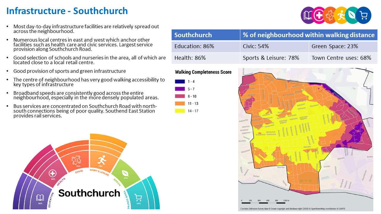
Southchurch ‘Aggregated Completeness Score’ = 66%
Map – as an example a high completeness score would be 14 –17 different facilities being within a reasonable walking distance from home. Conversely a low score would be less than 4 facilities within walking distance.
Question 3.6.3 Southchurch (Infrastructure)
Have your say………
Please explain your answers
a. Are there any issues with infrastructure provision in Southchurch? Please explain your answer and let us know what the priorities should be over the next 20 years.
3.6.4 Land Use Proposals - Southchurch
A number of potential land use proposals are identified for future housing, employment and open space. For each site, the location, proposed use and indicative amount of development (if applicable) is provided.
3.6.4.1 New Homes
The type and quality of the housing offer can have a significant impact on the health and wealth of places. Their ability to attract and retain people and provide support for those who need it relies on good housing and attractive and inclusive neighbourhoods.
Potential site proposals for residential development can be viewed in Map 43. Table 41 sets outs relevant information including, context and surrounding uses, proposed use, estimated number of new dwellings and what ‘components of growth’ the site contributes to in reference to Section 2: Housing Need (Table 2).
The sites have been promoted to us by landowners/ agents and are included here for comment. Table 41 also notes the amount of new homes that are likely to come forward over the lifetime of the plan through sites already with planning permission and windfall development.
For more information on each site an assessment can be viewed by clicking on the link reference in Table 41 below, or via the Councils website: Appendix 4: Site Proformas | Southend Local Plan
Map 43: Potential Residential Sites - Southchurch (excluding those with planning permission)
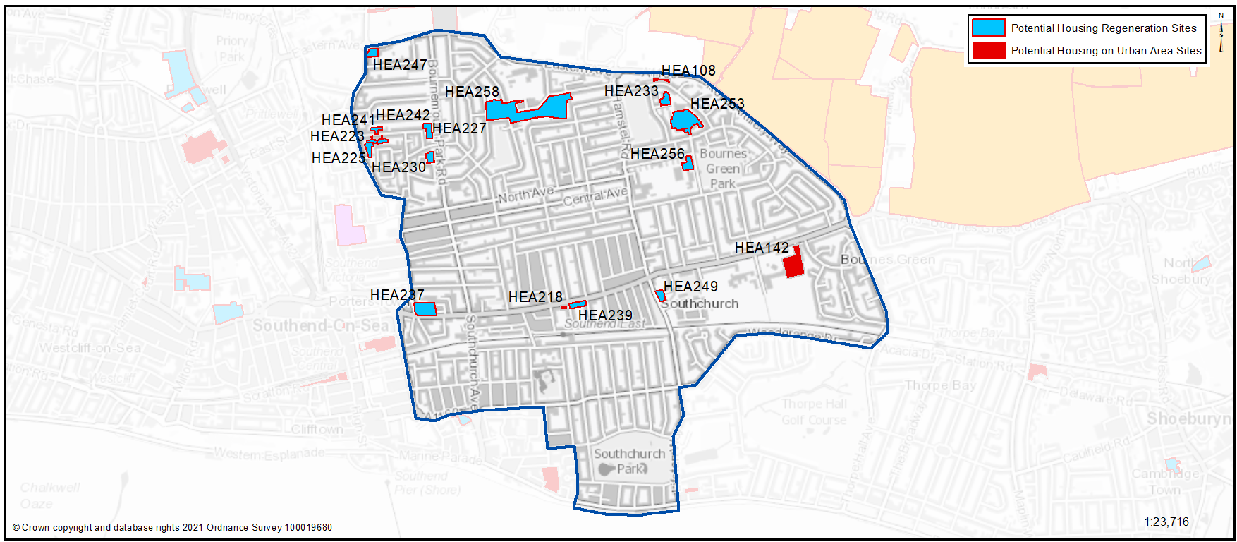
Table 41: Potential Residential Sites - Southchurch
Individual potential sites listed below
Question 3.6.4.1a Southchurch (Residential)
HEA108...Vacant land at Archer Avenue
HEA108
Context and Surrounding uses - The site currently includes green space off Archer Avenue, not designated, to the south of the Royal Artillery Way (A1159). In terms of the surrounding area, this is mainly residential with two storey housing bordering the site to the south, east and west. There are some mature trees to the west of the site.
Potential Land Use - The site has been put forward for residential development with the potential to improve the remaining green space
Potential Land Use (Summary) - Residential development, green space
Component of Change - Urban Area General
Estimated number of homes - Gross 6 Net 6
| https://localplan.southend.gov.uk/sites/localplan.southend/files/2021-08/Southchurch%20Proformas.pdf#page=1 |
Have your say…….
Please explain your answer
Question a - Do you agree with with the potential proposals for this site? Please explain your answer. You may wish to outline the type and scale of development you would like to see come forward in reference to Figure 27: Development Typologies
Question 3.6.4.1a Southchurch (Residential)
HEA142...School buildings and land, former Futures College, Southchurch Boulevard
HEA142
Context and Surrounding uses - Site includes school buildings. It is bordered to the rear by residential gardens. Southend High School for Girls is to the west. It forms part of a wider site to be combined for education purposes, with this part of the site intended to be released.
Potential Land Use - Council owned site submitted through the Call for Sites process for residential development.
Potential Land Use (Summary) - Residential development
Component of Change - Urban Area General
Estimated number of homes - Gross 20 Net 20
| https://localplan.southend.gov.uk/sites/localplan.southend/files/2021-08/Southchurch%20Proformas.pdf#page=2 |
Question a - Do you agree with with the potential proposals for this site? Please explain your answer. You may wish to outline the type and scale of development you would like to see come forward in reference to Figure 27: Development Typologies
Question 3.6.4.1a Southchurch (Residential)
HEA218...Car Park, Ilfracombe Avenue
HEA218
Context and Surrounding uses - Car park fronting Southchurch Road. Located adjacent to a Tesco Express/petrol station. In a mixed area, generally low-rise with retail, services and residential uses.
Potential Land Use - Council owned site submitted through the Call for Sites process for residential development
Potential Land Use (Summary) - Residential development
Component of Change - Urban Area General
Estimated number of homes - Gross 8 Net 8
| https://localplan.southend.gov.uk/sites/localplan.southend/files/2021-08/Southchurch%20Proformas.pdf#page=3 |
Question a - Do you agree with with the potential proposals for this site? Please explain your answer. You may wish to outline the type and scale of development you would like to see come forward in reference to Figure 27: Development Typologies
Question 3.6.4.1a Southchurch (Residential)
HEA223...Bronte Mews
HEA223
Context and Surrounding uses - Group of single storey properties currently occupied as sheltered housing. Located in a residential area accessed via a single road to Ruskin Avenue. Surrounded by low-rise housing.
Potential Land Use - Existing building in public ownership that may benefit from some renewal, redevelopment or expansion that could provide new and better quality homes that are designed to be adaptable so local people can reside independently through all stages of their lives. To gain a comprehensive understanding of development potential, all existing housing estates in public ownership have been included for comment. At the time of publication of this document no Council decision has been made on redeveloping this site.
Potential Land Use (Summary) - Residential development
Component of Change - Urban Area General
Estimated number of homes - Gross 7 Net 0
| https://localplan.southend.gov.uk/sites/localplan.southend/files/2021-08/Southchurch%20Proformas.pdf#page=4 |
Question a - Do you agree with with the potential proposals for this site? Please explain your answer. You may wish to outline the type and scale of development you would like to see come forward in reference to Figure 27: Development Typologies
Question 3.6.4.1a Southchurch (Residential)
HEA225...1-29 Cedar Close
HEA225
Context and Surrounding uses - Group of 3 and 2 storey buildings occupied as sheltered housing with on-site car park. In a residential area surrounded by low-rise housing.
Potential Land Use - Existing building in public ownership that may benefit from some renewal, redevelopment or expansion that could provide new and better quality homes that are designed to be adaptable so local people can reside independently through all stages of their lives. To gain a comprehensive understanding of development potential, all existing housing estates in public ownership have been included for comment. At the time of publication of this document no Council decision has been made on redeveloping this site.
Potential Land Use (Summary) - Residential development
Component of Change - Housing Regeneration Sites
Estimated number of homes - Gross 28 Net 0
| https://localplan.southend.gov.uk/sites/localplan.southend/files/2021-08/Southchurch%20Proformas.pdf#page=5 |
Question a - Do you agree with with the potential proposals for this site? Please explain your answer. You may wish to outline the type and scale of development you would like to see come forward in reference to Figure 27: Development Typologies
Question 3.6.4.1a Southchurch (Residential)
HEA227...1-33 Dickens Close
HEA227
Context and Surrounding uses - Group of 2 and 3 storey buildings occupied as sheltered housing in a residential area. Large car park fronting Ruskin Avenue. Surrounded by low-rise housing.
Potential Land Use - Existing building in public ownership that may benefit from some renewal, redevelopment or expansion that could provide new and better quality homes that are designed to be adaptable so local people can reside independently through all stages of their lives. To gain a comprehensive understanding of development potential, all existing housing estates in public ownership have been included for comment. At the time of publication of this document no Council decision has been made on redeveloping this site.
Potential Land Use (Summary) - Residential development
Component of Change - Housing Regeneration Sites
Estimated number of homes - Gross 32 Net 0
| https://localplan.southend.gov.uk/sites/localplan.southend/files/2021-08/Southchurch%20Proformas.pdf#page=6 |
Question a - Do you agree with with the potential proposals for this site? Please explain your answer. You may wish to outline the type and scale of development you would like to see come forward in reference to Figure 27: Development Typologies
Question 3.6.4.1a Southchurch (Residential)
HEA230...Keats House, Shelley Square
HEA230
Context and Surrounding uses - Part 1 and 2 storey sheltered housing building with car park. In a residential setting surrounded by low rise housing.
Potential Land Use - Existing building in public ownership that may benefit from some renewal, redevelopment or expansion that could provide new and better quality homes that are designed to be adaptable so local people can reside independently through all stages of their lives. To gain a comprehensive understanding of development potential, all existing housing estates in public ownership have been included for comment. At the time of publication of this document no Council decision has been made on redeveloping this site.
Potential Land Use (Summary) - Residential development
Component of Change - Housing Regeneration Sites
Estimated number of homes - Gross 57 Net 0
| https://localplan.southend.gov.uk/sites/localplan.southend/files/2021-08/Southchurch%20Proformas.pdf#page=7 |
Question a - Do you agree with with the potential proposals for this site? Please explain your answer. You may wish to outline the type and scale of development you would like to see come forward in reference to Figure 27: Development Typologies
Question 3.6.4.1a Southchurch (Residential)
HEA233...1-11 Lincoln Close
HEA233
Context and Surrounding uses - Series of bungalows fronting shared greenspace. Located in a residential area with primarily of 2 storey buildings. However there is a high rise tower to the south. A1159 to the north with sports facilities beyond.
Potential Land Use - Existing building in public ownership that may benefit from some renewal, redevelopment or expansion that could provide new and better quality homes that are designed to be adaptable so local people can reside independently through all stages of their lives.
Potential Land Use (Summary) - Residential development
Component of Change - Housing Regeneration Sites
Estimated number of homes - Gross 16 Net 5
| https://localplan.southend.gov.uk/sites/localplan.southend/files/2021-08/Southchurch%20Proformas.pdf#page=8 |
Question a - Do you agree with with the potential proposals for this site? Please explain your answer. You may wish to outline the type and scale of development you would like to see come forward in reference to Figure 27: Development Typologies
HEA237...Nicholson House & The Barringtons, 299 Southchurch Road
HEA237
Context and Surrounding uses - Two 7-storey blocks currently in use as sheltered housing. Large central car park between the two buildings and another court of homes. Prominent central location fronting the A13. The Grade I listed Porters is to the south west and will need to be considered in any development.
Potential Land Use - Existing building in public ownership that may benefit from some renewal, redevelopment or expansion that could provide new and better quality homes that are designed to be adaptable so local people can reside independently through all stages of their lives. To gain a comprehensive understanding of development potential, all existing housing estates in public ownership have been included for comment. At the time of publication of this document no Council decision has been made on redeveloping this site.
Potential Land Use (Summary) - Residential development
Component of Change - Housing Regeneration Sites
Estimated number of homes - Gross 171 Net 75
| https://localplan.southend.gov.uk/sites/localplan.southend/files/2021-08/Southchurch%20Proformas.pdf#page=9 |
Question a - Do you agree with with the potential proposals for this site? Please explain your answer. You may wish to outline the type and scale of development you would like to see come forward in reference to Figure 27: Development Typologies
Question 3.6.4.1a Southchurch (Residential)
HEA239...Nursery Place, 530-596 Southchurch Road
HEA239
Context and Surrounding uses - Predominantly 3 storey building fronting the A13. Parking on both the east and west of the building. The site is in a predominantly residential area but with multiple shops and services along the A13.
Potential Land Use - Existing building in public ownership that may benefit from some renewal, redevelopment or expansion that could provide new and better quality homes that are designed to be adaptable so local people can reside independently through all stages of their lives. To gain a comprehensive understanding of development potential, all existing housing estates in public ownership have been included for comment. At the time of publication of this document no Council decision has been made on redeveloping this site.
Potential Land Use (Summary) - Residential development
Component of Change - Housing Regeneration Sites
Estimated number of homes - Gross 34 Net 0
| https://localplan.southend.gov.uk/sites/localplan.southend/files/2021-08/Southchurch%20Proformas.pdf#page=10 |
Question a - Do you agree with with the potential proposals for this site? Please explain your answer. You may wish to outline the type and scale of development you would like to see come forward in reference to Figure 27: Development Typologies
Question 3.6.4.1a Southchurch (Residential)
HEA241...Ruskin Mews, 14-24 Ruskin Avenue
HEA241
Context and Surrounding uses - Group of bungalows set between a landscaped area with parking and direct access to Ruskin Avenue. The site is in a low rise residential area on a tightly bounded site.
Potential Land Use - Existing building in public ownership that may benefit from some renewal, redevelopment or expansion that could provide new and better quality homes that are designed to be adaptable so local people can reside independently through all stages of their lives. To gain a comprehensive understanding of development potential, all existing housing estates in public ownership have been included for comment. At the time of publication of this document no Council decision has been made on redeveloping this site.
Potential Land Use (Summary) - Residential development
Component of Change - Housing Regeneration Sites
Estimated number of homes - Gross 7 Net 1
| https://localplan.southend.gov.uk/sites/localplan.southend/files/2021-08/Southchurch%20Proformas.pdf#page=11 |
Question a - Do you agree with with the potential proposals for this site? Please explain your answer. You may wish to outline the type and scale of development you would like to see come forward in reference to Figure 27: Development Typologies
Question 3.6.4.1a Southchurch (Residential)
HEA242...Kipling Mews
HEA242
Context and Surrounding uses - Group of single storey buildings currently in use as sheltered housing. In a residential area accessed via a single road to Ruskin Avenue. Surrounded by low-rise housing.
Potential Land Use - Existing building in public ownership that may benefit from some renewal, redevelopment or expansion that could provide new and better quality homes that are designed to be adaptable so local people can reside independently through all stages of their lives. To gain a comprehensive understanding of development potential, all existing housing estates in public ownership have been included for comment. At the time of publication of this document no Council decision has been made on redeveloping this site.ts.
Potential Land Use (Summary) - Residential development
Component of Change - Housing Regeneration Sites
Estimated number of homes - Gross 5 Net 0
| https://localplan.southend.gov.uk/sites/localplan.southend/files/2021-08/Southchurch%20Proformas.pdf#page=12 |
Question a - Do you agree with with the potential proposals for this site? Please explain your answer. You may wish to outline the type and scale of development you would like to see come forward in reference to Figure 27: Development Typologies
HEA247...The Brambles, 20 Eastern Avenue
HEA247
Context and Surrounding uses - 1 - 3 storey building currently in use as sheltered accommodation. The site is in a prominent location on a roundabout fronting the A1159. Nearby sports pitches and industrial uses.
Potential Land Use - Existing building in public ownership that may benefit from some renewal, redevelopment or expansion that could provide new and better quality homes that are designed to be adaptable so local people can reside independently through all stages of their lives. To gain a comprehensive understanding of development potential, all existing housing estates in public ownership have been included for comment. At the time of publication of this document no Council decision has been made on redeveloping this site.
Potential Land Use (Summary) - Residential development
Component of Change - Housing Regeneration Sites
Estimated number of homes - Gross 39 Net 0
| https://localplan.southend.gov.uk/sites/localplan.southend/files/2021-08/Southchurch%20Proformas.pdf#page=13 |
Question a - Do you agree with with the potential proposals for this site? Please explain your answer. You may wish to outline the type and scale of development you would like to see come forward in reference to Figure 27: Development Typologies
Question 3.6.4.1a Southchurch (Residential)
HEA249...Trevett House, 19a Rectory Chase
HEA249
Context and Surrounding uses - Part 2 & 3 storey building in use as sheltered accommodation. Site fronts the sloping Lifstan Way with main access from the rear. Surrounding area is mixed with retail, residential, and public house.
Potential Land Use - Existing building in public ownership that may benefit from some renewal, redevelopment or expansion that could provide new and better quality homes that are designed to be adaptable so local people can reside independently through all stages of their lives. To gain a comprehensive understanding of development potential, all existing housing estates in public ownership have been included for comment. At the time of publication of this document no Council decision has been made on redeveloping this site.
Potential Land Use (Summary) - Residential development
Component of Change - Housing Regeneration Sites
Estimated number of homes - Gross 29 Net 0
| https://localplan.southend.gov.uk/sites/localplan.southend/files/2021-08/Southchurch%20Proformas.pdf#page=14 |
Question a - Do you agree with with the potential proposals for this site? Please explain your answer. You may wish to outline the type and scale of development you would like to see come forward in reference to Figure 27: Development Typologies
Question 3.6.4.1a Southchurch (Residential)
HEA253...Longbow and Sherwood Way
HEA253
Context and Surrounding uses - Large area of Council owned housing stock currently in residential use. The buildings primarily consist of 3 storey flatted developed surrounding a central 13 storey tower block with car parking.
Potential Land Use - Existing building in public ownership that may benefit from some renewal, redevelopment or expansion that could provide new and better quality homes that are designed to be adaptable so local people can reside independently through all stages of their lives. To gain a comprehensive understanding of development potential, all existing housing estates in public ownership have been included for comment. At the time of publication of this document no Council decision has been made on redeveloping this site.
Potential Land Use (Summary) - Residential development
Component of Change - Housing Regeneration Sites
Estimated number of homes - Gross 299 Net 147
| https://localplan.southend.gov.uk/sites/localplan.southend/files/2021-08/Southchurch%20Proformas.pdf#page=15 |
Question a - Do you agree with with the potential proposals for this site? Please explain your answer. You may wish to outline the type and scale of development you would like to see come forward in reference to Figure 27: Development Typologies
Question 3.6.4.1a Southchurch (Residential)
HEA256...Bewley Court
HEA256
Context and Surrounding uses - 11 storey tower block with car parking fronting Whittingham Avenue. Residential surroundings adjacent to a church and Bournes Green Park.
Potential Land Use - Existing building in public ownership that may benefit from some renewal, redevelopment or expansion that could provide new and better quality homes that are designed to be adaptable so local people can reside independently through all stages of their lives. To gain a comprehensive understanding of development potential, all existing housing estates in public ownership have been included for comment. At the time of publication of this document no Council decision has been made on redeveloping this site.
Potential Land Use (Summary) - Residential development
Component of Change - Housing Regeneration Sites
Estimated number of homes - Gross 76 Net 0
| https://localplan.southend.gov.uk/sites/localplan.southend/files/2021-08/Southchurch%20Proformas.pdf#page=16 |
Question a - Do you agree with with the potential proposals for this site? Please explain your answer. You may wish to outline the type and scale of development you would like to see come forward in reference to Figure 27: Development Typologies
Question 3.6.4.1a Southchurch (Residential)
HEA258...Cluny Square
HEA258
Context and Surrounding uses - Residential estate including a range of low rise units and high-rise buildings. Includes Cluny Square which includes play spaces and a shopping frontage.
Potential Land Use - Existing building in public ownership that may benefit from some renewal, redevelopment or expansion that could provide new and better quality homes that are designed to be adaptable so local people can reside independently through all stages of their lives. To gain a comprehensive understanding of development potential, all existing housing estates in public ownership have been included for comment. At the time of publication of this document no Council decision has been made on redeveloping this site.
Potential Land Use (Summary) - Residential (including retention of local green space and re-provision of retail)
Component of Change - Housing Regeneration Sites
Estimated number of homes - Gross 361 Net 95
| https://localplan.southend.gov.uk/sites/localplan.southend/files/2021-08/Southchurch%20Proformas.pdf#page=17 |
Question a - Do you agree with with the potential proposals for this site? Please explain your answer. You may wish to outline the type and scale of development you would like to see come forward in reference to Figure 27: Development Typologies
Question 3.6.4.1b Southchurch (Residential)
Question b. Do you have any other comments on housing provision in Southchurch? If yes, please explain your answer.
3.6.4.2 Urban Form and Development Typologies
Good quality urban design will be essential in new housing development if the character of the neighbourhood is to be enhanced.
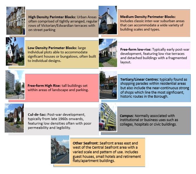
Map 44 shows the Urban Forms of Southchurch neighbourhood. This has been informed by the Southend Borough Wide Character Study and is intended to provide a broad overview of the types and densities of development across the neighbourhood; this can range from low density, areas of detached housing, to high rise flats.
To assist with the preparation of development management and design policies, which will impact the scale, type and density of new homes, we are interested in your views on broadly what types of development you think should come forward in the neighbourhood. It may be that there are different parts of the neighbourhood that you think could accommodate different types of development.
Figure 27 provides a range of development typologies at different densities, for both houses and flats. We’d like to know whether there is a particular typology that you’d like to see come forward in Southchurch, including the scale and form of any future residential development site listed in Table 41, and within the different Urbans Forms as shown in Map 44. For instance you may believe the ‘Linear Centre’ of the Southchurch Road within Map 44 should accommodate higher density development, such as flats typology F2 and F3, within Figure 27. Please select those densities you feel are most appropriate for each site. You may wish to take account of surrounding uses and the accessibility of the site.
Figure 27 - Development Typologies 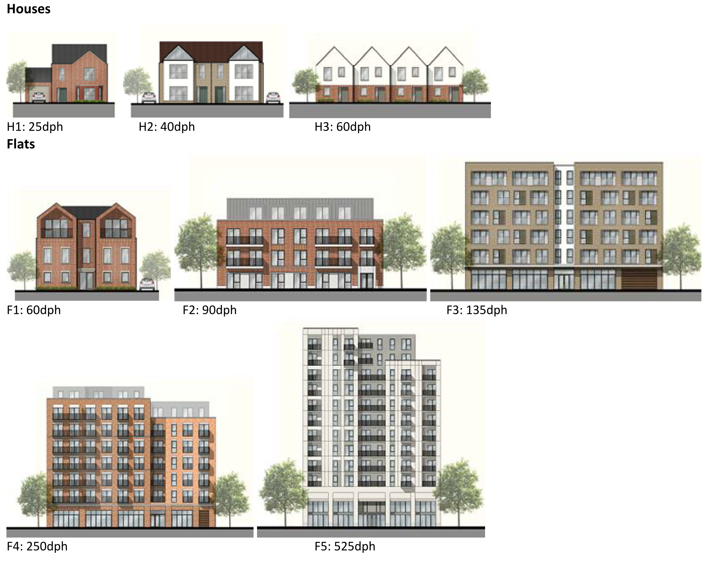
Map 44: Urban Form of Southchurch
Question 3.6.4.2 Southchurch (Urban Form)
Have your say………
Please explain your answers
a. Are there development typologies (Figure 27) that you would like to see come forward in Southchurch? Please explain your answer - you may wish to refer to the different urban forms presented in Map 44 in your answer.
To view our mapping feature showing Urban Forms: Southend-on-Sea Borough Council – Local Plan: Map 2 Urban Forms Map (opus4.co.uk)
3.6.4.3 Employment
There are no allocated employment sites within Southchurch, however there are a number of employment areas located just outside the boundary. These are Tickfield, Short Street, Priory Works, Stock Road and Temple Farm Industrial Estate. The retention and provision of employment sites is necessary to enable balanced job and housing growth. However, Grainger Road performs poorly as an employment area and is unlikely to attract sufficient occupiers and it is therefore proposed to re-allocate for residential redevelopment.
3.6.4.4 Commercial Centres
To ensure the vitality of town centres, the National Planning Policy Framework encourages local planning authorities to implement planning policies and decisions that support the role that town centres play at the heart of local communities, by taking a positive approach to their growth, management, and adaptation.
The Government recently introduced changes to the Use Classes Order which consolidates a wide range of uses including retail, food, financial services, gyms, healthcare, nurseries, offices, and light industry into a single use class (Use Class E) and any change of use of a building or land between those uses falling within this Use Class will not require planning permission. It is therefore proposed to define as “Commercial Areas”, centres where we will promote ground floor uses to be within Class E Use Class and encourage improvements to shopfronts and the street scene.
There are a range of commercial centres in the Borough that protect ground floor uses for business purposes (use class E*) and thereby perform a vital function by ensuring communities are served by a range of retail and commercial services. The Commercial Centres in Southchurch are shown on Map 45 and detailed in Table 43.
As of August 2021, the Government is also introducing expanded permitted development rights to enable Commercial Uses to be converted to residential without planning permission. Due to this there are limitations on safeguarding ground floor commercial uses within key centres from changing to residential. However, under Article 4 of the General Permitted Development Order a local planning authority can apply to the Secretary of State to withdraw specified permitted development rights across a defined area. The use of Article 4 directions should not be expansive and therefore if we were to use them to restrict ground floor commercial uses from changing to residential, we must focus them to the most important frontages. In reference to Map 45 and Table 43 we are interested in your views on which centres we should investigate for using Article 4 Directions in order to restrict ground floor commercial frontages from being developed to residential under permitted development.
Map 45: Southchurch Commercial Centres
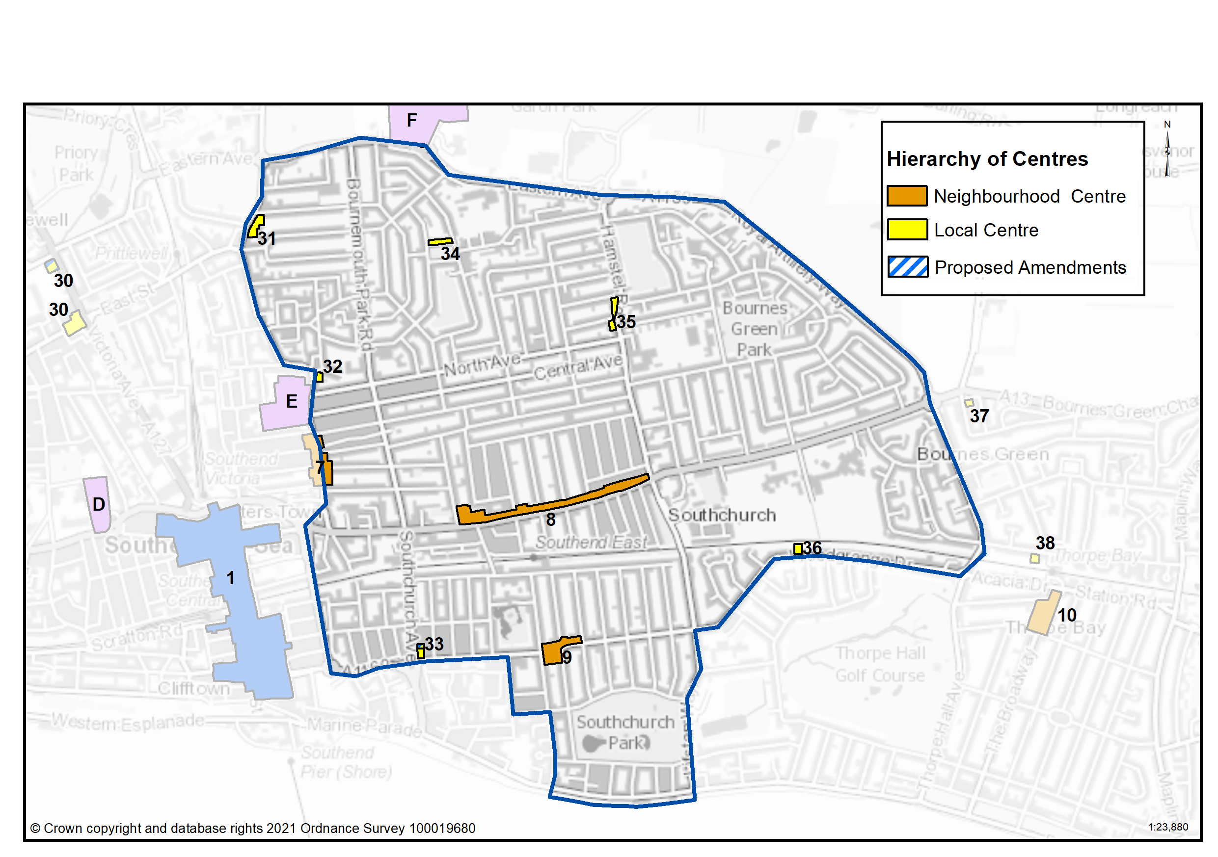
Table 43: Southchurch Commercial Centres
|
Ref |
Name |
Centre Type |
|---|---|---|
|
8 |
Southchurch Road |
Neighbourhood Centre |
|
9 |
Woodgrange Drive |
Neighbourhood Centre |
|
31 |
Sutton Road North |
Local Centre |
|
32 |
Sutton Road Centre |
Local Centre |
|
33 |
Southchurch Avenue |
Local Centre |
|
34 |
Cluny Square |
Local Centre |
|
35 |
Hamstel Road |
Local Centre |
| 36 |
Woodgrange Drive East |
Local Centre |
| 37 | Fossetts Park | Out of Town Retail Parks |
Question 3.6.4.4a Southchurch (Commercial Centres)
Have your say…….
Please explain your answer
Question a - Should we seek to define Southchurch Road as a Neighbourhood Centre as set out in Table 43 to promote a range of commercial uses to serve local community needs and provide local employment opportunities?
Question a - Should we seek to define Woodgrange Drive as a Neighbourhood Centre as set out in Table 43 to promote a range of commercial uses to serve local community needs and provide local employment opportunities?
Question a - Should we seek to define Sutton Road North as a Local Centre as set out in Table 43 to promote a range of commercial uses to serve local community needs and provide local employment opportunities?
Question a - Should we seek to define Sutton Road Centre as set out in Table 43 to promote a range of commercial uses to serve local community needs and provide local employment opportunities?
Question a - Should we seek to define Southchurch Avenue as a Local Centre as set out in Table 43 to promote a range of commercial uses to serve local community needs and provide local employment opportunities?
Question a - Should we seek to define Cluny Square as a Local Centre as set out in Table 43 to promote a range of commercial uses to serve local community needs and provide local employment opportunities?
Question a - Should we seek to define Hamstel Road as a Local Centre as set out in Table 43 to promote a range of commercial uses to serve local community needs and provide local employment opportunities?
Question a - Should we seek to define Woodgrange Drive East as a Local Centre as set out in Table 43 to promote a range of commercial uses to serve local community needs and provide local employment opportunities?
Question a - Should we seek to define Fossetts Park as an Out of Town Retail Park as set out in Table 43 to promote a range of commercial uses to serve local community needs and provide local employment opportunities?
Question 3.6.4.4b Southchurch (Commercial Centres)
Question b - Should we investigate using Article 4 direction to safeguard ground floor commercial uses within the town, district and neighbourhood centres by restricting permitted development changes to residential – if yes, what frontages?
Question 3.6.4.4c Southchurch (Commercial Centres)
Question c - Are there other areas within the Southchurch Neighbourhood area that we haven’t identified that should be protected for commercial activities? If yes, please explain your answer and let us know where.
3.6.4.5 Green Space
National planning policy allows for Local Plans to identify and protect existing green space so it is not built on unless an assessment demonstrates the open space, buildings or land are surplus to requirements; any open space lost would be replaced by equivalent or better provision in terms of quantity, quality and access; or the benefits of new sports and recreation facilities clearly outweigh the loss of the current or former use as open space. In this respect the New Local Plan seeks to protect the green spaces as set out in Table 44 and Map 46.
Existing Green Space
Southchurch Park and Southchurch Hall Gardens are Green Flag parks with a range of facilities. Bournes Green Park, Cluny Square and Christchurch Park also include a children’s playground, and there are several other smaller parks and amenity spaces in the neighbourhood. There are also number of allotment sites within the neighbourhood including Lifstan Way, Hamstel Road and Norwich Avenue. Jones Memorial, Victory and New Youth Sports Grounds lie just outside the neighbourhood to the north, along with Garon Park Leisure complex. Tree canopy cover in the neighbourhood ranges from 9.4% of the ward in Kursaal to 12.7% in St Luke’s ward. This is set within the context of the Council’s Tree Policy which sets a target to extend the overall tree canopy cover in the Borough from 12% to 15% by 2050. Opportunities for enhancement of green space will be pursued wherever possible.
Local Green Space
National planning policy allows local authorities to designate land as Local Green Space through their local plans, so that communities can identify and protect green areas of particular importance to them, for example because of its historic significance, recreational value, tranquillity, beauty or richness of its wildlife. Policies for managing Local Green Space are consistent with those for Green Belts.
Proposed Local Green Space – Southchurch Park has a lake, children’s playground, wildlife garden and café, and hosts Southend Manor Football Club. It is well used by the local community and is valued for beauty, recreation and as a tranquil respite within a dense urban area. It is therefore proposed to be protected as a Local Green Space. Southchurch Hall Gardens is also proposed as Local Green Space because of its heritage significance, biodiversity and tranquillity attributes. The outcome of this consultation will be particularly important in demonstrating that the space is special to the local community.
Proposed New Open Spaces
It is proposed to protect Southchurch Boulevard, which runs through the centre of the Neighbourhood, as a Linear Green Space, reflecting its amenity, biodiversity and recreational value. In addition, Christchurch Park is an existing public green space containing a children’s playground that is not currently protected. It is therefore proposed to protect the site as a Local Park (see Table 44a for more details).
Map 46: Protected Green Space in Southchurch and Proposed Green Space
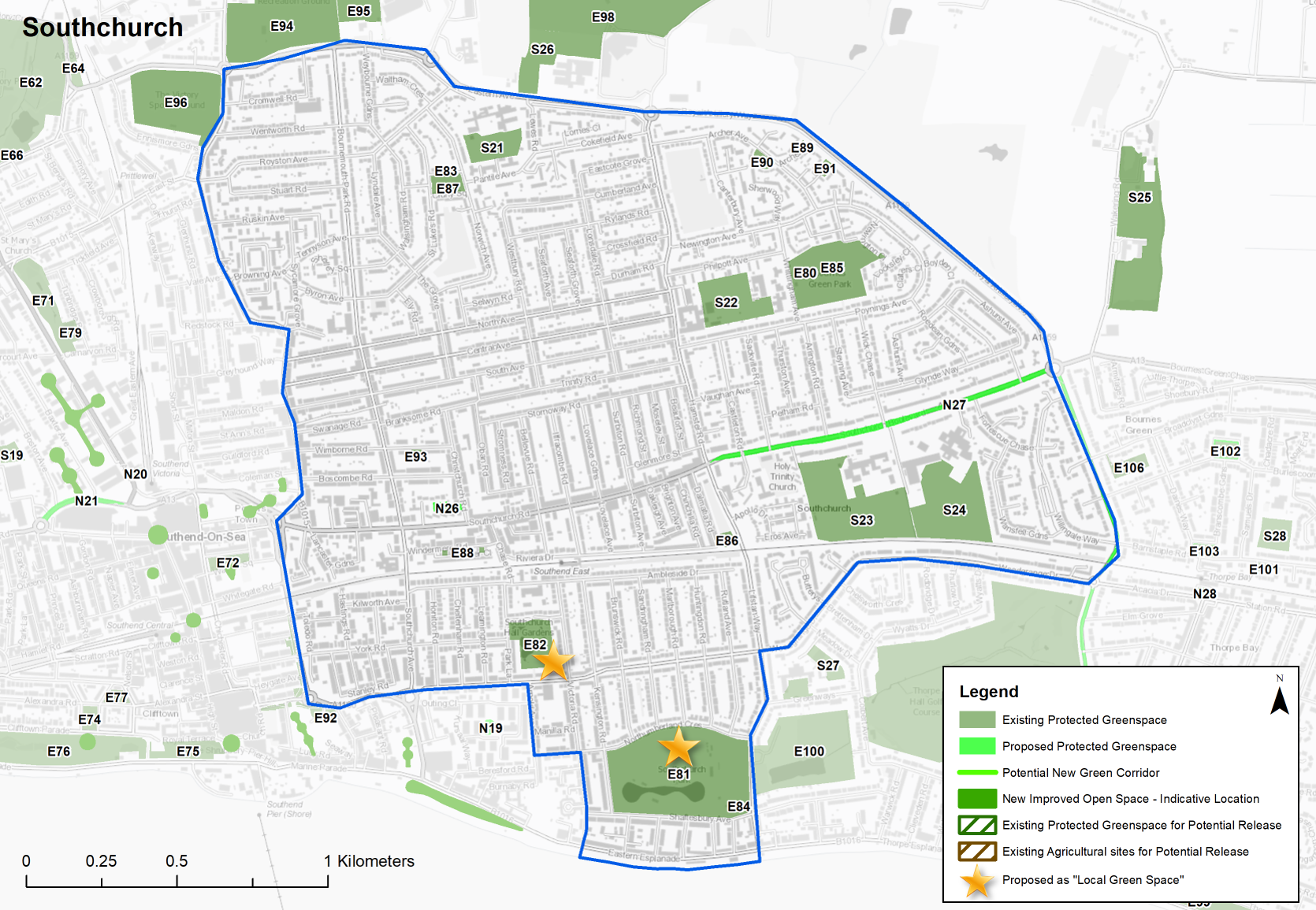
Table 44: Existing Public Green Space in Southchurch
|
Site Ref. |
Name of Site |
Size (Ha) |
|
Site Ref. |
Name of Site |
Size (Ha) |
|---|---|---|---|---|---|---|
|
Local Parks |
Sports Ground |
|||||
|
E80 |
Bournes Green Park |
4.579 |
E93 |
Wimbourne Road Bowling Green |
0.126 |
|
|
E81 |
Southchurch Park |
11.809 |
School |
|||
|
E82 |
Southchurch Hall Gardens |
1.901 |
S21 |
Temple Sutton Primary School |
1.549 |
|
|
Playgrounds |
S22 |
Hamstel School |
2.941 |
|||
|
E83 |
Cluny Square Playground |
0.243 |
S23 |
Southend High School for Girls |
6.628 |
|
|
E84 |
Southchurch Park Play Area |
0.526 |
S24 |
Futures College |
5.248 |
|
|
E85 |
Bournes Green Park Play Equipment |
0.125 |
Crematorium, Graveyard or Cemetery |
|||
|
E86 |
Lifstan Way |
0.169 |
C7 |
Holy Trinity Churchyard |
0.891 |
|
|
Amenity Open Space |
C8 |
Sutton Road Cemetery |
21.846 |
|||
|
E87 |
Cluny Square |
0.375 |
C9 |
Sutton Road Crematorium |
4.027 |
|
|
E88 |
Windermere Road |
0.092 |
Allotments |
|||
|
E89 |
Archer Avenue |
0.091 |
A8 |
Hamstel Road |
3.504 |
|
|
E90 |
Archer Close |
0.267 |
A9 |
Lifstan Way |
0.496 |
|
|
E91 |
Vallance Close |
0.150 |
A10 |
Norwich Avenue |
1.789 |
|
|
E92 |
Queensway to Woodgrange Drive Clusters (part) |
0.648 |
|
|||
|
Green Space adjacent to neighbourhood |
|
Green Space adjacent to neighbourhood |
||||
|
Site Ref. |
Name of Site |
Size (Ha) |
Site Ref. |
Name of Site |
Size (Ha) |
|
|
Sports Grounds |
School |
|||||
|
E94 |
Jones Memorial Sports Ground |
10.944 |
S25 |
Allen Court School |
6.911 |
|
|
E95 |
Part of Fossets Farm SUFC Training Ground |
4.140 |
S26 |
Cecil Jones College |
2.871 |
|
|
E96 |
Victory Sports Ground |
5.759 |
|
|||
|
E97 |
Warners Bridge Sports Ground |
10.448 |
||||
|
E98 |
Garon Park |
17.624 |
||||
Sites in bold are proposed as ‘Local Green Space’
Table 44a: Southchurch – Proposed new green space - Individual sites listed below with question
Question 3.6.4.5a Southchurch (Green Space)
Have your say………
Please explain your answers
N26...Christchurch Park
Local Park
Site Ref - N26
Name of Site - Christchurch Park
Size (Ha) - 0.239
Question a - Do you agree with this proposed new green space designation?
N27...Southchurch Boulevard
Linear Green Space
Site Ref - N27
Name of Site - Southchurch Boulevard
Size (Ha) - 1.983
Question a - Do you agree with this proposed new green space designation?
A11...Eastern Avenue*
Allotments
Site Ref - A11
Name of Site - Southchurch Boulevard
Size (Ha) - 4.500
*Located close to the North of the Southchurch
Question a - Do you agree with this proposed new green space designation?
Question 3.6.4.5b Southchurch (Green Space)
Question b - Are there other areas we haven't identified that should be protected or promoted for green infrastructure? Please provide an address.
Question 3.6.4.5c Southchurch (Green Space)
Question c. Do you agree with Southchurch Park and Southchurch Hall Gardens being identified as Local Green Space? If not, can you explain why?
Question 3.6.4.5d Southchurch (Green Space)
Question d. Are there any other sites within Southchurch that should be designated as Local Green Space? If yes, please provide an explanation. Any proposals must be supported by evidence the space is special to the local community in terms of beauty, historic significance, recreational value, tranquillity, wildlife or is special to the local community for other reasons.
Question 3.6.4.5e Southchurch (Green Space)
Question e. Do you have any other comments on green space provision in Southchurch? If yes, please explain your answer.
2 2011 Census based on Wards, 3 nurseries, primary schools, secondary schools, doctors, dentists, pharmacies, libraries, places of worship, public conveniences, community centres and halls, playing pitches, local equipped play space, amenity greenspace, allotments, natural and semi-natural greenspace, local and neighbourhood centres, town and district centres, * https://www.legislation.gov.uk/uksi/2020/757/made