3.7.1 General Character
Thorpe Bay is an affluent area, characterised by low density housing. It is bisected by the east-west main railway line and is served by Thorpe Bay station. To the south of the railway line and east of Thorpe Hall Avenue the area is characterised by a strong grid pattern drawn to generous proportions with wide plots of large, predominantly detached Edwardian and Inter-war housing, as well as a substantial phase of post-war bungalows and houses. The neighbourhood centre of Thorpe Broadway lies south of the station, providing a range of local shops and services to the neighbourhood (see Map 47 and Figure 28).
Tree lined streets are a particular feature of the area, especially in the Burges Estate and benefits from attractive gardens, tennis courts, bowling green, as well as access to the seafront. To the west is a golf course and an area of largely smaller post-war housing, a proportion of which is located in the flood risk zone, to its north. North of the railway line is Bournes Green, a planned interwar development that was built out after World War Two, and a large area of housing dating from the 1980s to the west of Maplin Way North. The form of development is heavily influenced by the garden city movement, both in terms of building design and layout of a loose grid pattern, including small cul-de-sac in each block. To the northern extent of the neighbourhood Bournes Green Chase currently acts as a clear boundary to the built-up area. Land north of this is currently in agricultural use and designated as Green Belt. This land, however, has potential as a new neighbourhood on the edge of Southend, including a mix of uses and provision of new public accessible green space, as part of Strategy Option C and D (see Section 2.1: Providing New Homes). Thorpe Bay has the lowest density within the Borough with approximately 12.8 homes per hectare.
Given the low densities in the neighbourhood, there is potential for some limited intensification of development, subject to respecting scale and character. Development along the seafront may be possible but the grain and scale of the area would need to be respected to preserve the areas distinct character.
Map 47: Thorpe Bay Characteristics
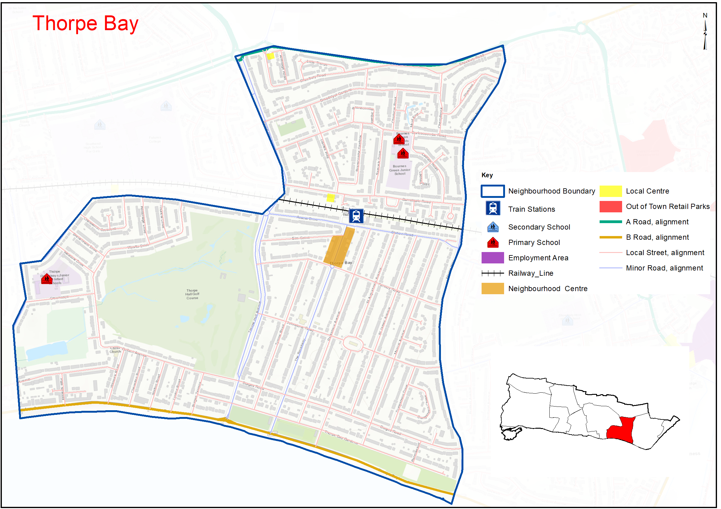
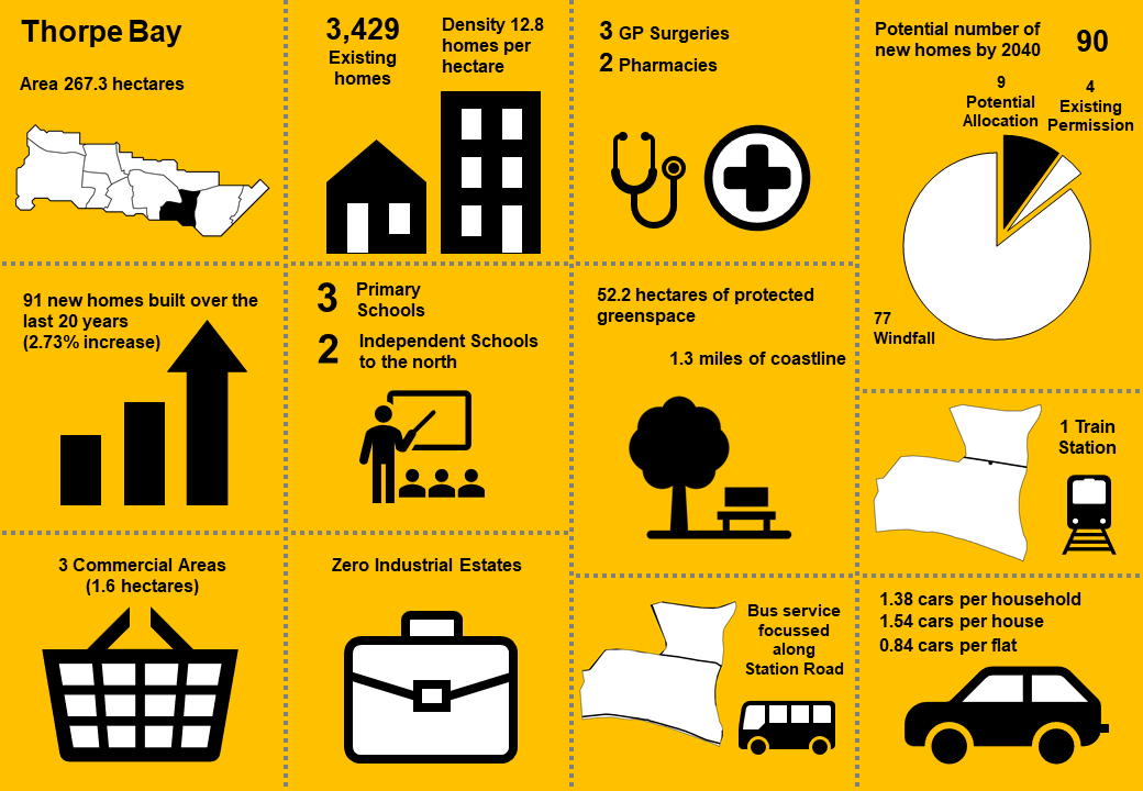
Figure 28: Thorpe Bay Characteristics
|
No. Homes |
3,429 |
Land Area (ha) |
267.3 |
|
Density |
12.8 dph |
Car Ownership |
1.38 |
3.7.2 Vision - Thorpe Bay
Where we want to be
Thorpe Bay will remain an attractive residential area that benefits from landscaping and a strong tree canopy, with any selective redevelopment complementing local character. Thorpe Broadway neighbourhood centre will remain the commercial core of the neighbourhood, providing a range of shops and services to meet the day to day needs of the local community. There will be high quality walking, cycling and bus connections with the potential new neighbourhood north of Bournes Green Chase. A draft range of priorities for Thorpe Bay is set out below to aid feedback:
- Where acceptable in principle, new development in Thorpe Bay should be of high quality, respect the character of the area and incorporate greenery.
- Potential development of a major new community to the north of Bournes Green Chase, including a mix of uses and provision of new public accessible green space, with walking and cycling routes between the new community and existing neighbourhood.
- Thorpe Broadway neighbourhood centre to continue to act as a retail and service hub for the community, and fringes of the neighbourhood benefit from good services in Southchurch and Shoebury.
- Thorpe Bay Station to be a transport hub and new north-south cycle routes linked into this.
- The character and function of the foreshore will be conserved, protecting its value for different users while planning for the impacts of climate change and mitigating flood risk.
- There will continue to be good access to health and community facilities for local residents.
- Existing areas of Open Space will be retained and enhanced, with the potential new neighbourhood to the north of Bournes Green Chase providing opportunity for additional open green space, which will be accessible to residents in Thorpe Bay neighbourhood.
Question 3.7.2 Thorpe Bay (Vision)
Have your say………
Please explain your answers
a. Do you agree with our draft vision and priorities for Thorpe Bay? If not, let us know what we have missed.
3.7.3 Complete Neighbourhoods (accessibility to services and facilities)
The following profile seeks to build up a picture of the ‘completeness’ of Thorpe Bay neighbourhood. Completeness is based on mapping the walking catchments around different day to day facilities (17 different facilities in total). The catchment areas vary by facility and reflect comfortable walking distances for the average, able-bodied person. The catchments are based on actual walking routes rather than ‘as the crow flies’ distances.
A high completeness score means a place has lots of facilities the community needs within an easy walking distance. This approach recognises the important links to health and social well-being, community cohesion and inclusion.
The completeness score for Thorpe Bay, by infrastructure type, is summarised in the rainbow image below. For example 91% of the neighbourhood lies within walking distance of health facilities and 71% within walking distance of education facilities, but only 45% of the neighbourhood is within walking distance of civic, town centre and sport and leisure uses, while 18% is within easy reach of green space.
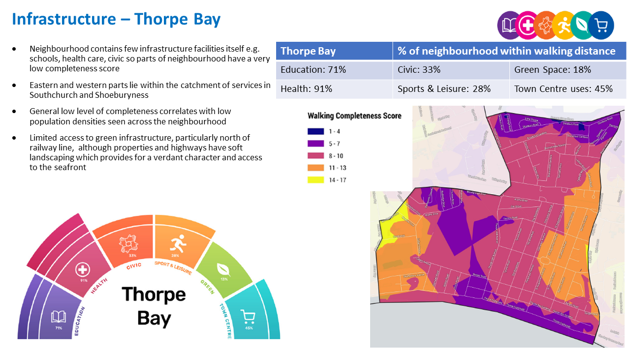
Thorpe Bay ‘Aggregated Completeness Score’ = 68%
Map – as an example a high completeness score would be 14 –17 different facilities being within a reasonable walking distance from home. Conversely a low score would be less than 4 facilities within walking distance.
Question 3.7.3 Thorpe Bay (Infrastructure)
Have your say………
Please explain your answers
a. Are there any issues with infrastructure provision in Thorpe Bay? Please explain your answer and let us know what the priorities should be over the next 20 years?
3.7.4 Land Use Proposals – Thorpe Bay
Limited potential land use proposals are identified for future housing, and open space. For each site, the location, proposed use and indicative amount of development (if applicable) is provided.
For more information on each site an assessment can be viewed by clicking on the site reference in Table 45 below, or via the Council’s website: https://localplan.southend.gov.uk/
3.7.4.1 New Homes
The type and quality of the housing offer can have a significant impact on the health and wealth of places. Their ability to attract and retain people and provide support for those who need it relies on good housing and attractive and inclusive neighbourhoods.
Potential site proposals for residential development can be viewed in Map 48. Table 45 sets outs relevant information including, context and surrounding uses, proposed use, estimated number of new dwellings and what ‘components of growth’ the site contributes to in reference to Section 2: Housing Need (Table 2).
The sites have been promoted to us by landowners/ agents and are included here for comment. Table 45 also notes the amount of new homes that are likely to come forward over the lifetime of the plan through sites already with planning permission and windfall development.
For more information on each site an assessment can be viewed by clicking on the link reference in Table 45 below, or via the Councils website: Appendix 4: Site Proformas | Southend Local Plan
Map 48: Potential Residential Sites – Thorpe Bay (excluding those with planning permission)
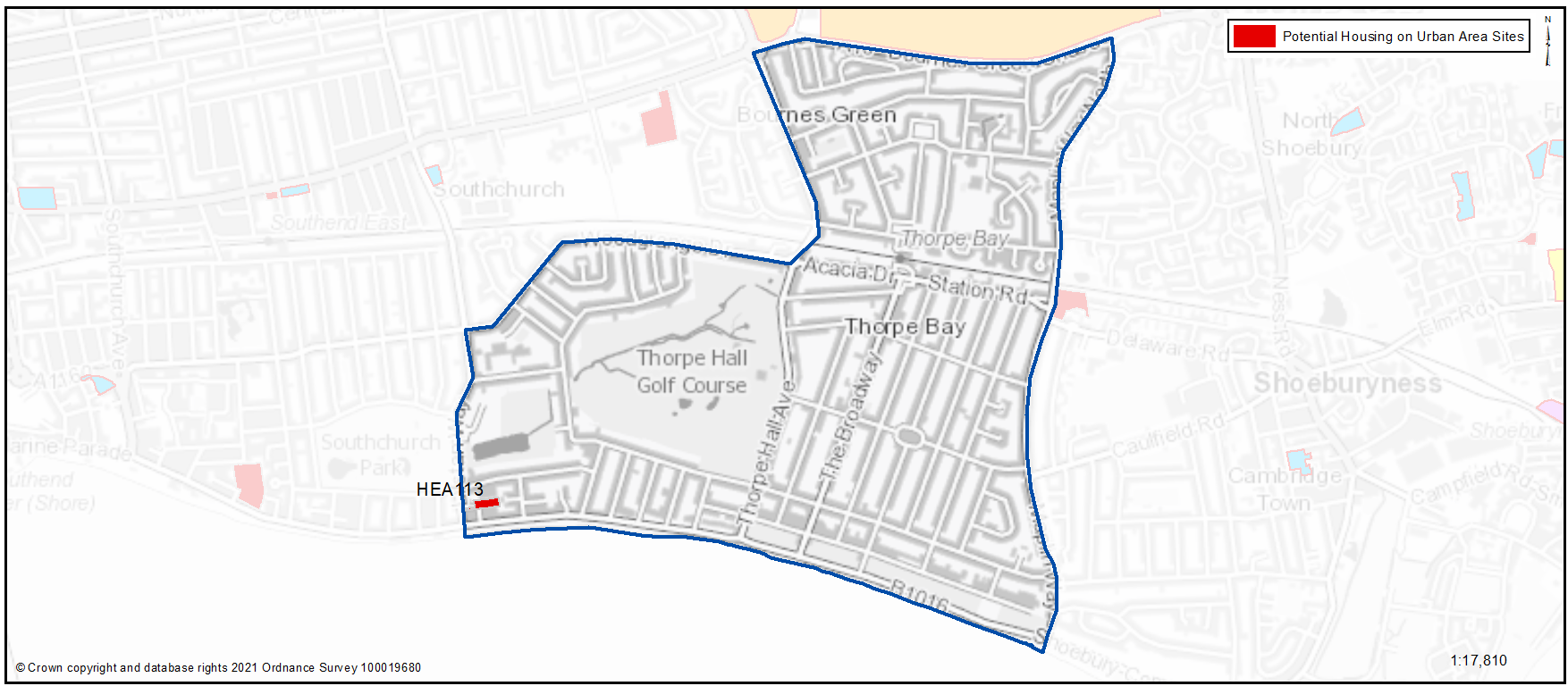
Table 45: Potential Residential Sites – Thorpe Bay
See individual site below
Question 3.7.4.1a Thorpe Bay (Residential)
HEA113...Land rear of Camelia Hotel
HEA113
Context and Surrounding uses - Backland site forming rear of properties on Shaftsbury Avenue, Eastern Esplanade and Lifstan Way. In use as informal parking, providing access to a series of garages. The site is located within flood zone 3.
Potential Land Use - This Council owned site has been submitted through the Call for Sites process for potential residential development. A low-density scheme of 35 dph would equate to 9 dwellings (rounded) and should allow for enough land to appropriately deal with the noted constraints..
Potential Land Use (Summary) - Residential development
Component of Change - Urban Area General
Estimated number of homes - Gross 9 Net 9
| https://localplan.southend.gov.uk/sites/localplan.southend/files/2021-08/Thorpe%20Bay%20Proformas.pdf#page=1 |
a. Do you agree with the potential proposals for this site? Please explain your answer. You may wish to outline the type and scale of development you would like to see come forward in reference to Figure 29: Development Typologies.
Question 3.7.4.1b Thorpe Bay (Residential)
b. Do you have any other comments on housing provision in Thorpe Bay?
3.7.4.2 Urban Form and Development Typologies
Good quality urban design will be essential in new housing development if the character of the neighbourhood is to be enhanced.
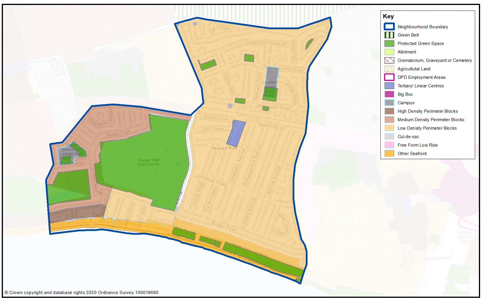
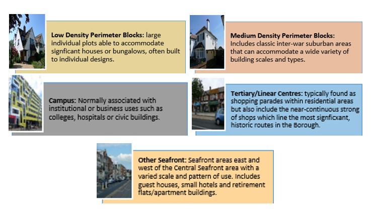
Map 49 shows the Urban Forms of Thorpe Bay neighbourhood. This has been informed by the Southend Borough Wide Character Study and is intended to provide a broad overview of the types and densities of development across the neighbourhood; this can range from low density, areas of detached housing, to high rise flats.
To assist with the preparation of development management and design policies, which will impact the scale, type and density of new homes, we are interested in your views on broadly what types of development you think should come forward in the neighbourhood. It may be that there are different parts of the neighbourhood that you think could accommodate different types of development.
Figure 29 provides a range of development typologies at different densities, for both houses and flats. We’d like to know whether there is a particular
typology that you’d like to see come forward in Thorpe Bay and within the different Urbans Forms as shown in Map 49. For instance you may believe the established residential area within Map 49 should accommodate lower density development, such as house typologies H1 and H2, while you may believe the area around Thorpe Bay Station should accommodate development of a higher density, such as flat typology F2, within Figure 29.
Figure 29 - Development Typologies 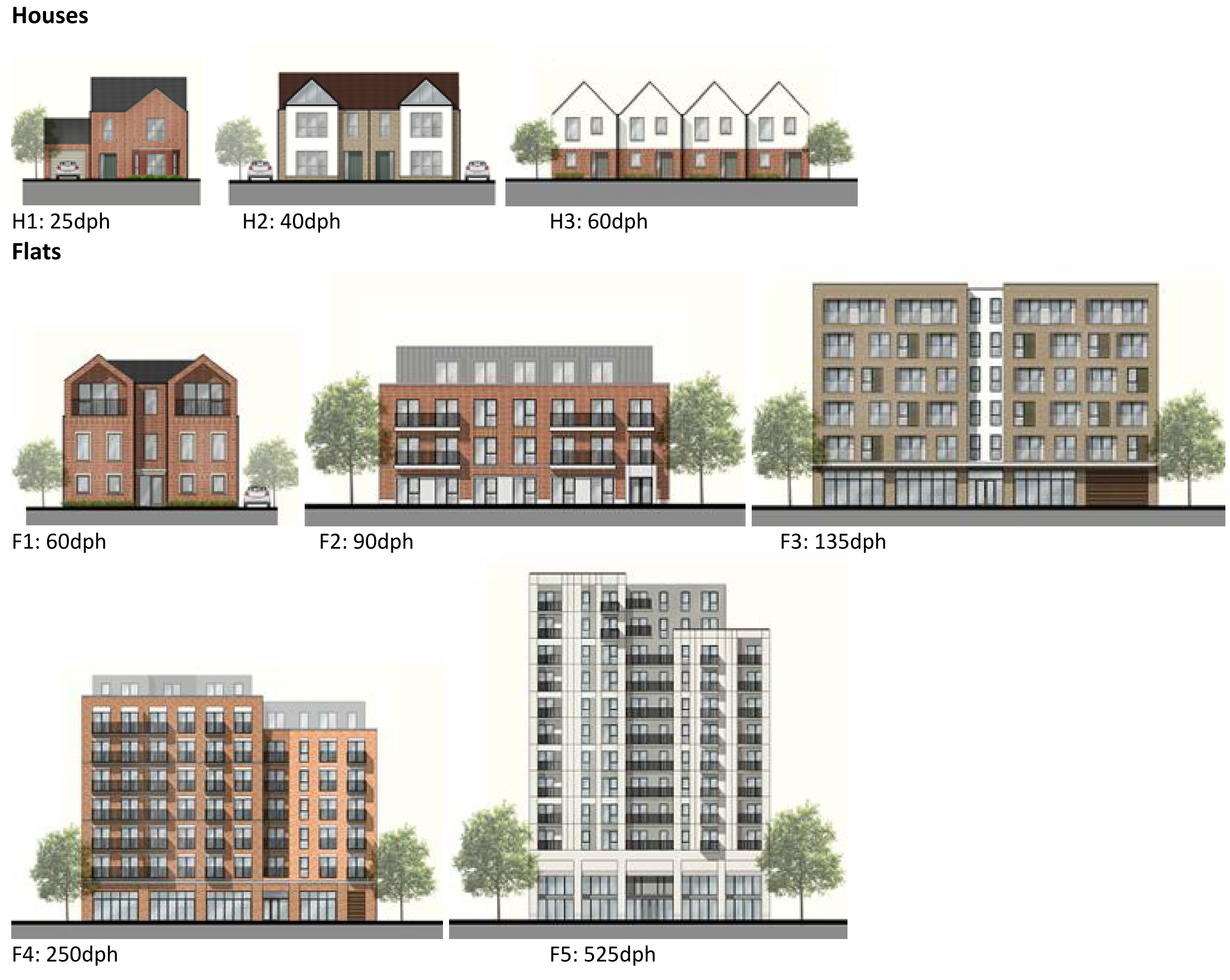
Map 49: Urban Form of Thorpe Bay
Question 3.7.4.2 Thorpe Bay (Urban Form)
Have your say………
Please explain your answers
a. Are there development typologies (Figure 29) that you would like to see come forward in Thorpe Bay? Please explain you answer - you may wish to refer to the different urban forms presented in Map 49 in your response.
To view our mapping feature showing Urban Forms: Southend-on-Sea Borough Council – Local Plan: Map 2 Urban Forms Map (opus4.co.uk)
3.7.4.3 Employment
There are no proposals for new employment provision or existing designations in Thorpe Bay.
3.7.4.4 Commercial Centres
To ensure the vitality of town centres, the National Planning Policy Framework encourages local planning authorities to implement planning policies and decisions that support the role that town centres play at the heart of local communities, by taking a positive approach to their growth, management, and adaptation.
The Government recently introduced changes to the Use Classes Order which consolidates a wide range of uses including retail, food, financial services, gyms, healthcare, nurseries, offices, and light industry into a single use class (Use Class E) and any change of use of a building or land between those uses falling within this Use Class will not require planning permission. It is therefore proposed to define as “Commercial Areas”, centres where we will promote ground floor uses to be within Class E Use Class and encourage improvements to shopfronts and the street scene.
There are a range of commercial centres in the Borough that protect ground floor uses for business purposes (use class E5) and thereby perform a vital function by ensuring communities are served by a range of retail and commercial services. Map 50 and Table 46 shows the commercial centres in Thorpe Bay.
As of August 2021, the Government is also introducing expanded permitted development rights to enable Commercial Uses to be converted to residential without planning permission. Due to this there are limitations on safeguarding ground floor commercial uses within key centres from changing to residential. However, under Article 4 of the General Permitted Development Order a local planning authority can apply to the Secretary of State to withdraw specified permitted development rights across a defined area. The use of Article 4 directions should not be expansive and therefore if we were to use them to restrict ground floor commercial uses from changing to residential, we must focus them to the most important frontages. In reference to Map 50 and Table 46 we are interested in your views on which centres we should investigate for using Article 4 Directions in order to restrict ground floor commercial frontages from being developed to residential under permitted development.
Map 50: Thorpe Bay Commercial Centres
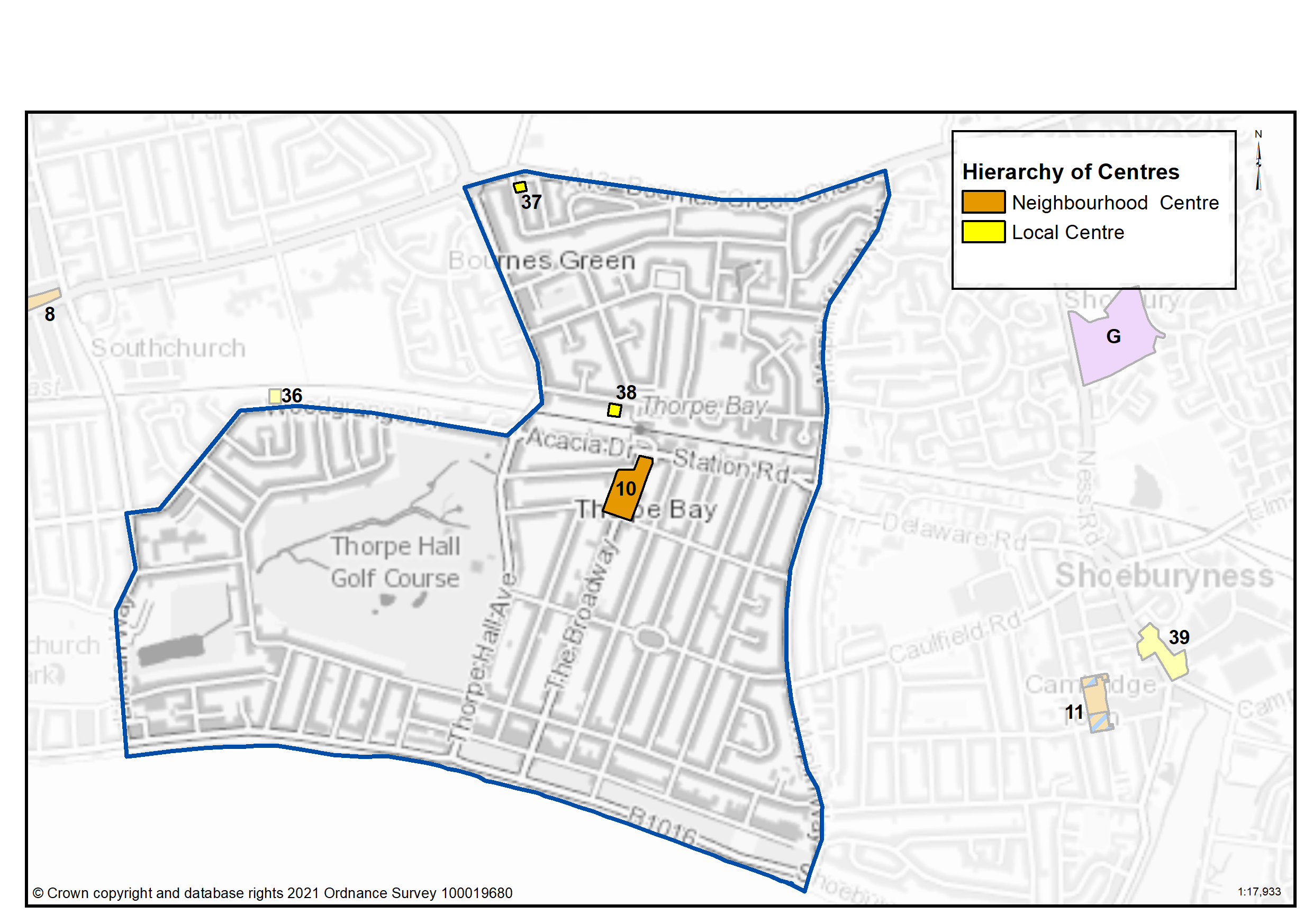
Table 46: Thorpe Bay Commercial Centres
|
Ref |
Name |
Centre Type |
|---|---|---|
|
10 |
Thorpe Bay (Broadway) |
Neighbourhood Centre |
|
37 |
Shoebury Road (Bournes Green) |
Local Centre |
|
38 |
Barnstaple Road |
Local Centre |
Question 3.7.44a Thorpe Bay (Commercial Centres)
a. Should we seek to define Thorpe Bay (Broadway) as a Neighbourhood Centre as set out in Table 46 to promote a range of commercial uses to serve local community needs and provide local employment opportunities
a. Should we seek to define Shoebury Road (Bournes Green) as a Local Centre as set out in Table 46 to promote a range of commercial uses to serve local community needs and provide local employment opportunities?
a. Should we seek to define Barnstaple Road as a Local Centre as set out in Table 46 to promote a range of commercial uses to serve local community needs and provide local employment opportunities?
Question 3.7.44b Thorpe Bay (Commercial Centres)
b. Should we investigate using Article 4 direction to safeguard ground floor commercial uses within the town, district and neighbourhood centres by restricting permitted development changes to residential – if yes, what frontages?
Question 3.7.44c Thorpe Bay (Commercial Centres)
c. Are there any other areas within the Thorpe Bay Neighbourhood area that we haven’t identified that should be protected for commercial activities? If yes, please explain your answer and let us know where.
3.7.4.5 Green Space
National planning policy allows for Local Plans to identify and protect existing green space so it is not built on unless an assessment demonstrates the open space, buildings or land are surplus to requirements; any open space lost would be replaced by equivalent or better provision in terms of quantity, quality and access; or the benefits of new sports and recreation facilities clearly outweigh the loss of the current or former use as open space. In this respect the New Local Plan seeks to protect the green spaces as set out in Table 47 and Map 51.
Existing Green Space
Green Spaces in Thorpe Bay include the formal and natural green space at Southchurch Park East, the formally laid out Thorpe Bay Gardens on the foreshore and a number of smaller amenity spaces clustered around the north side of the railway line. The wide grass verge of Thorpe Hall Avenue also provides a recreational resource for residents including for dog walking. In addition, the Thorpe Hall private golf course provides a large area of green space with extensive tree cover and is traversed by a local public footpath link. These green facilities together with the lower density nature of development in the area, particularly south of the railway which includes properties with large gardens and wide-grassed verged streets, as well as extensive tree cover, means that the neighbourhood is verdant in character. Tree canopy cover in the neighbourhood is 13% of the Thorpe ward. This is set within the context of the Council’s Tree Policy which sets a target to extend the overall tree canopy cover in the Borough from 12% to 15% by 2050.
Local Green Space
National planning policy allows local authorities to designate land as Local Green Space through their local plans, so that communities can identify and protect green areas of particular importance to them, for example because of its historic significance, recreational value, tranquillity, beauty or richness of its wildlife. Policies for managing Local Green Space are consistent with those for Green Belt.
Proposed Local Green Space - Thorpe Bay Gardens is a grassed area opposite the foreshore. It is the main recreational space for the neighbourhood, and is valued in the main for the wide expansive views of the Estuary it offers. It therefore performs a key role for Thorpe Bay neighbourhood and is proposed as a Local Green Space. In addition Thorpe Hall golf course is proposed as Local Green Space as the largest and best quality green space in the neighbourhood. Unlike the other Local Green Spaces proposed in the plan the site is privately owned; however it does benefit from a public right of way through the site, offering connections to the wider green infrastructure network. Views are sought on whether the site plays a special role for the wider community as well as for Golf Club members, for example for its biodiversity role or tranquillity value, that would justify its designation as a Local Green Space.
Proposed New Green Space
The wide grass verge of Thorpe Hall Avenue also provides a recreational resource for residents including for dog walking, but is not currently protected. It is therefore proposed to designate this as Linear Green Space. Thorpe Bay Station Gardens is a formally laid out garden with mature trees and shrubs which is not currently protected, so it is proposed to designate this space as Amenity Open Space.
Map 51: Protected Green Space in Thorpe Bay and Proposed New Green Space
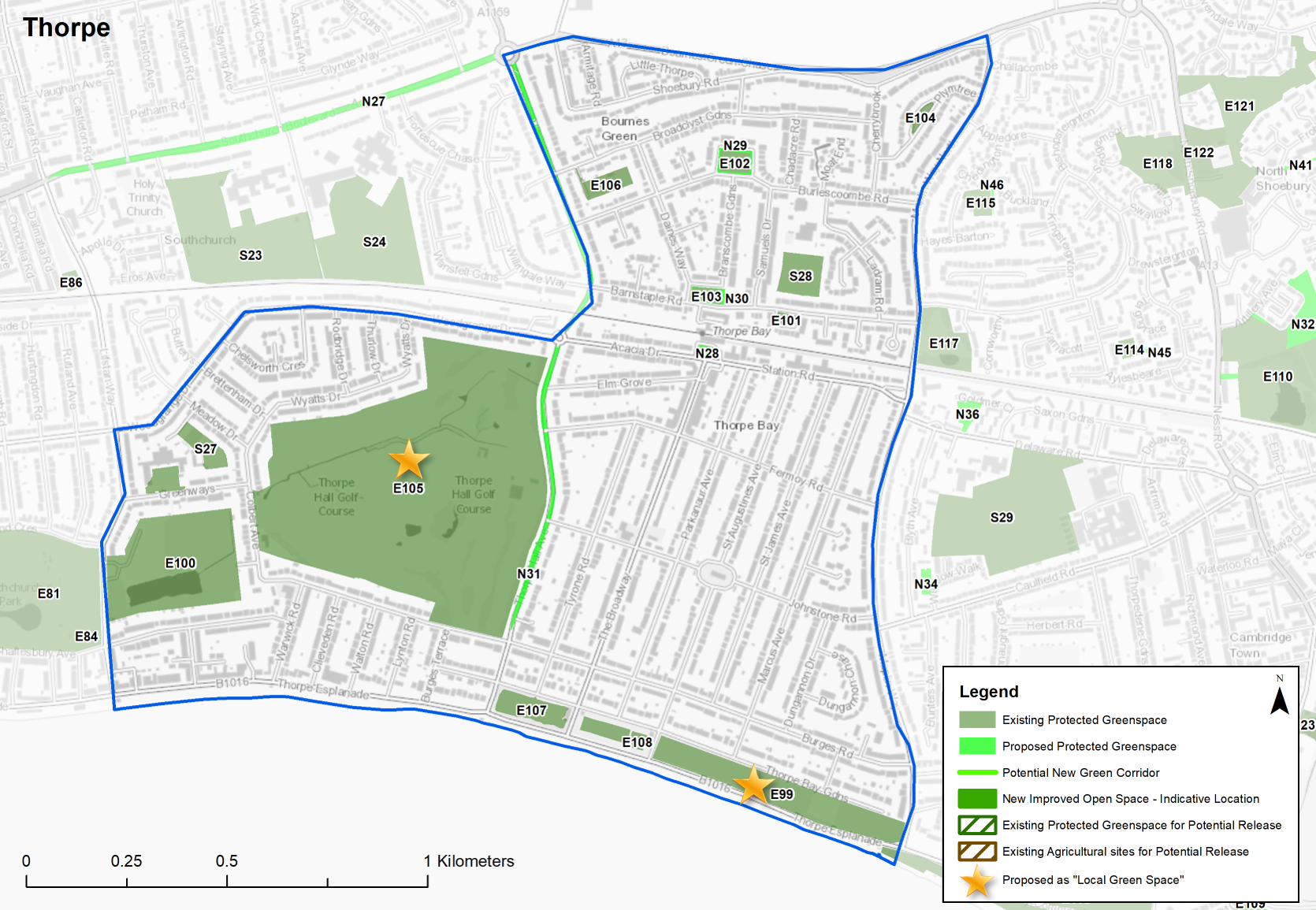
Table 47: Thorpe Bay – Protected Green Space
|
Site Ref. |
Name of Site |
Size (Ha) |
|
Site Ref. |
Name of Site |
Size (Ha) |
|
Local Park |
Sports Grounds |
|||||
|
E99 |
Thorpe Bay Gardens |
4.184 |
E105 |
Thorpe Hall Golf Course |
35.690 |
|
|
E100 |
Southchurch Park East |
7.094 |
E106 |
Broadclyst Gardens |
0.577 |
|
|
Amenity Open Space |
E107 |
Thorpe Esplanade Tennis Courts |
1.392 |
|||
|
E101 |
Barnstaple Road |
0.130 |
E108 |
Thorpe Bay Bowling Club |
0.157 |
|
|
E102 |
Branscombe Square |
0.372 |
School |
|||
|
E103 |
Burleigh Square |
0.265 |
S27 |
Thorpe Greenways Playing Fields |
1.101 |
|
|
E104 |
Plymtree |
0.155 |
S28 |
Bournes Green School |
1.036 |
|
Sites in bold are proposed as ‘Local Green Space’
Table 47a: Thorpe Bay – Proposed new green space
Individual sites listed below with question
Question 3.7.4.5a Thorpe Bay (Green Infrastructure)
N28...Thorpe Bay Station Gardens
Amenity Open Space
Site Ref - N28
Name of Site - Thorpe Bay Station Gardens
Size (Ha) - 0.139
Question a - Do you agree with this proposed new green space designation?
N29... Branscome Square (enlarged)
Amenity Open Space
Site Ref - N29
Name of Site - Branscome Square (enlarged)
Size (Ha) - 0.136
Question a - Do you agree with this proposed new green space designation?
N30...Burleigh Square (enlarged)
Amenity Open Space
Site Ref - N30
Name of Site - Burleigh Square (enlarged)
Size (Ha) - 0.050
Question a - Do you agree with this proposed new green space designation?
N31... Thorpe Hall Avenue
Linear Green Space
Site Ref - N31
Name of Site - Thorpe Hall Avenue
Size (Ha) - 1.502
Question a - Do you agree with this proposed new green space designation?
Question 3.7.4.5b Thorpe Bay (Green Infrastructure)
Question b - Are there any other areas we haven’t identified that should be protected or promoted for green infrastructure? If yes, please provide an address.
Question 3.7.4.5c Thorpe Bay (Green Infrastructure)
E99...Thorpe Bay Gardens
Local Park
Site Ref - E99
Name of Site - Thorpe Bay Gardens
Size (Ha) - 4.184
Question c - Do you agree with the proposed designation of Thorpe Bay Gardens as Local Green Space (Table 48)? If not, please let us know why.
E105...Thorpe Bay Golf Course
Sports Ground
Site Ref - E105
Name of Site - Thorpe Hall Golf Course
Size (Ha) - 35.690
Question c - Do you agree with the proposed designation of Thorpe Bay Golf Course as Local Green Space?
Question 3.7.4.5d Thorpe Bay (Green Infrastructure)
d) Are there any other spaces within Thorpe Bay that should be designated as Local Green Space? If yes, please provide an address and supporting evidence to outline how, for example the space is special in terms of beauty, historic significance, recreational value, tranquillity, wildlife or is special to the local community for other reasons.
Question 3.7.4.5e Thorpe Bay (Green Infrastructure)
e. Do you have any other comments on green space provision inThorpe Bay? If yes, please explain your answer.