3.8.1 General Character
The eastern most neighbourhood in the Borough, Shoeburyness is perhaps one of the most fragmented of the areas in Southend, displaying a wide range of spatial and architectural characteristics over a number of distinct zones (Map 52 and Figure 30). The Garrison is a significant feature of the area, an important example of Victorian military establishment design with a strong urban form much of which is protected by Conservation Area status set in a generous layout of green spaces and parkland which abuts the coastline. The Garrison buildings have largely been converted to residential uses, and other areas of the wider site have been built out for residential, developed to integrate with the original form. The Garrison, and the neighbouring East Beach, forms part of the attractiveness of the area for tourism.
The rest of South Shoebury is more influenced by the neighbouring Thorpe Bay, following a grid pattern with relatively large plots although tight knit Victorian/Edwardian terraced housing predominates around the West Road neighbourhood centre and local centre in Shoebury High Street, both of which provide a range of shops and services. North Shoebury is characterised by cul-de-sac, often lacking in terms of legibility and permeability, and open-plan modern low-rise development. The area contains an out of town retail development, anchored by a large ASDA store. To the north, Bournes Green Chase / Poynters Lane, currently act as a clear boundary to the built-up area. Land north of this is currently in agricultural use and designated as Green Belt. This land has, however, potential as a new neighbourhood on the edge of Southend as part of Strategy Option C and D (see Section 2.1: Providing New Homes), which could provide a new link road, country park, homes, jobs, education and health facilities and other supporting infrastructure.
Shoebury is also home to employment / industrial areas, providing an important local employment base. However, some of the older traditional industrial areas are in need of renewal or reallocation to other uses, and some employment allocations on the Garrison are primarily now in residential use. The MOD/Qinetic still maintains a presence on the “New Ranges” and provides local employment.
There is a wide variation in socio economic conditions within the area. The Index of multi-deprivation indicates that areas around Delaware Road and the eastern end of Eagle Way are within the lowest 10% of Lower Super Output Areas in the country. In contrast parts of Shoeburyness, particularly in the north and west of the area are among the least deprived nationally.
Map 52: Shoeburyness Characteristics
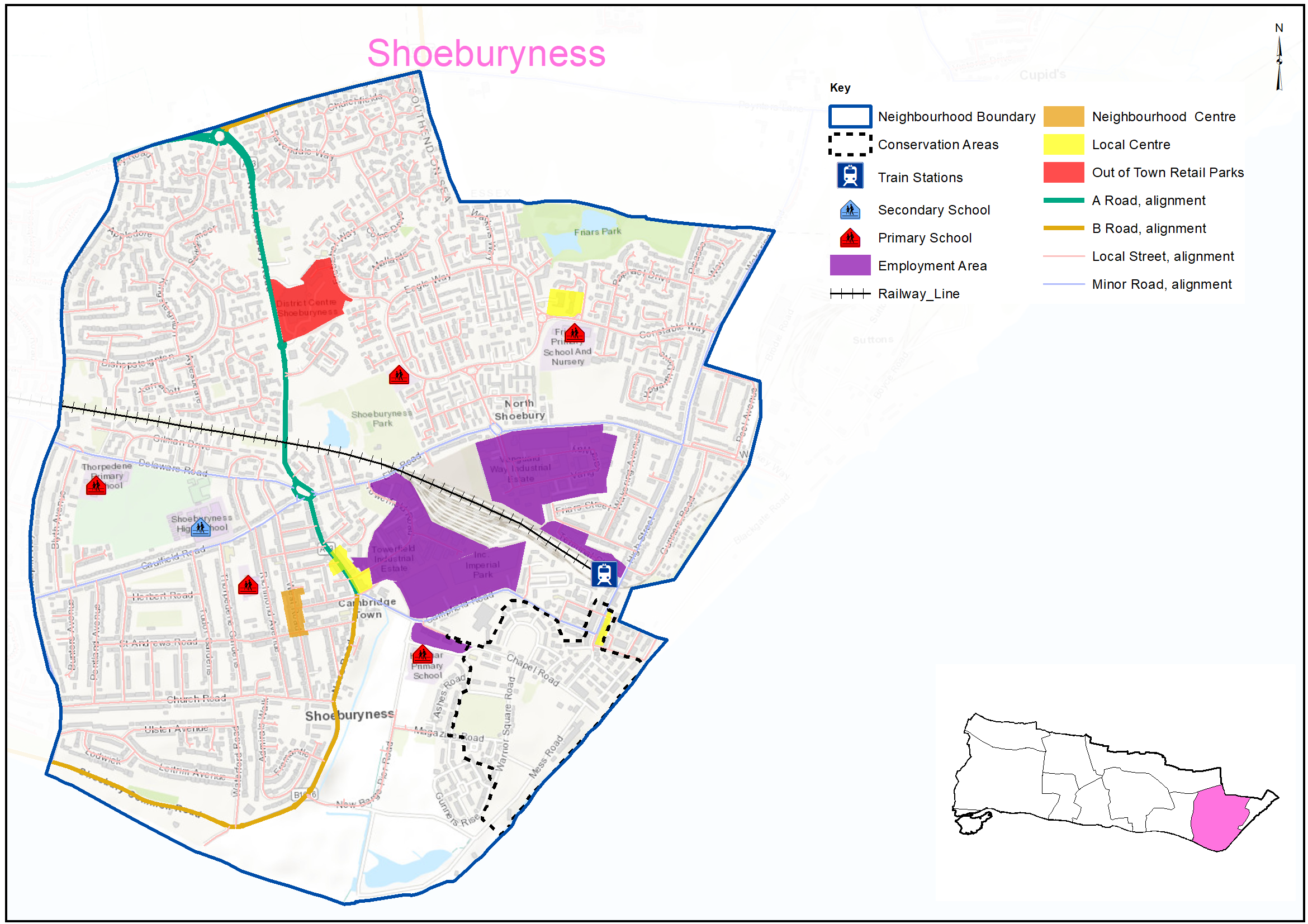
Figure 30: Shoeburyness Characteristics
|
No. Homes |
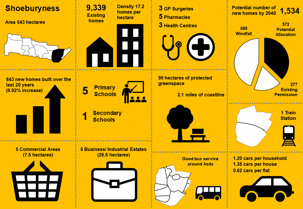
9,339 |
Land Area (ha) |
543 |
|
Density |
17.2 dph |
Car Ownership |
1.2 |
3.8.2 Vision - Shoeburyness
Where we want to be
For Shoeburyness to grow in a sustainable way and adapt to change in a positive manner, enhancing its existing characteristics. The historic core around the Garrison will be conserved and East Beach carefully managed for both its tourism and ecological value. The range of local centres and facilities will be allowed to evolve and be enhanced to facilitate the role of Shoeburyness as a complete neighbourhood. To aid feedback a draft set of priorities for Shoeburyness is included below:
- New housing, where acceptable in principle, will be of high quality and enhance the characteristics of the local area.
- The Shoebury Garrison Conservation Area and other designated heritage assets will be conserved and enhanced.
- The environmental quality of employment areas will be enhanced, and the existing stock upgraded
- Opportunities to improve the offer of existing neighbourhood and local centres and shopping parades to serve the day to day needs of the local community will be encouraged, including community facilities and healthcare services, with improved walking and cycling connections to surrounding residential areas.
- Working with partners to facilitate East Beach as a key tourism, recreational and environmental asset, including sustainable access and enhanced links to Shoeburyness Railway Station.
- Effectively integrating Shoeburyness with potential new development to the north of Bournes Green Chase/Poynters Lane, potentially including new link road and new country park.
- Seek to enhance existing green space.
Question 3.8.2 Shoeburyness (Vision)
Have your say………
Please explain your answers
a. Do you agree with our draft vision and priorities for Shoeburyness? If not, let us know what we have missed.
3.8.3 Complete Neighbourhoods (accessibility to services and facilities)
The following profile seeks to build up a picture of the ‘completeness’ of Shoeburyness. Completeness is based on mapping the walking catchments around different day to day facilities (17 different facilities in total) 6. The catchment areas vary by facility and reflect comfortable walking distances for the average, able-bodied person. The catchments are based on actual walking routes rather than ‘as the crow flies’ distances.
A high completeness score means a place has lots of facilities the community needs within an easy walking distance. This approach recognises the important links to health and social well-being, community cohesion and inclusion.
The completeness score for Shoeburyness, by infrastructure type, is summarised in the rainbow image below. For example 66% of the neighbourhood lies within easy walking distance to a health facility, 80% of the neighbourhood is within easy walking distance of sports and leisure facilities, while 24% is within easy reach of green space.
Shoeburyness ‘Aggregated Completeness Score’ = 53%
Map – as an example a high completeness score would be 14 –17 different facilities being within a reasonable walking distance from home. Conversely a low score would be less than 4 facilities within walking distance.
Question 3.8.3 Shoeburyness (Infrastructure)
Have your say…….
Please explain your answer
a. Are there any issues with infrastructure provision in Shoeburyness? Please explain your answer and let us know what the priorities should be over the next 20 years.
3.8.4 Land Use Proposals – Shoeburyness
A number of potential land use proposals are identified for future housing, employment and open space. For each site, the location, proposed use and indicative amount of development (if applicable) is provided.
3.8.4.1 New Homes
The type and quality of the housing offer can have a significant impact on the health and wealth of places. Their ability to attract and retain people and provide support for those who need it relies on good housing and attractive and inclusive neighbourhoods.
Potential site proposals for residential development can be viewed in Map 53. Table 48 sets outs relevant information including, context and surrounding uses, proposed use, estimated number of new dwellings and what ‘components of growth’ the site contributes to in reference to Section 2: Housing Need (Table 2).
The sites have been promoted to us by landowners/ agents and are included here for comment. Table 48 also notes the amount of new homes that are likely to come forward over the lifetime of the plan through sites already with planning permission and windfall development.
For more information on each site an assessment can be viewed by clicking on the link reference in Table 48 below, or via the Councils website: Appendix 4: Site Proformas | Southend Local Plan
Map 53: Potential Residential Sites - Shoeburyness (excluding those with planning permission)
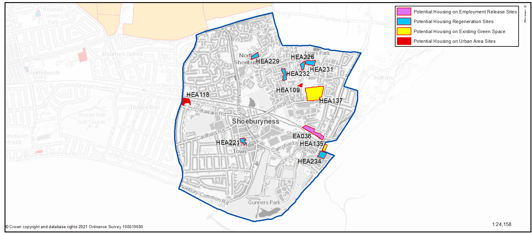
Table 48: Potential Residential Sites - Shoeburyness
Individual Potential Sites listed below
Question 3.8.4.1a Shoeburyness (Residential)
HEA109...Parking Area and adjacent areas at Eagle Way
HEA109
Context and Surrounding uses - A former Council owned garage site which has since been demolished with the area left open for parking. The land to the north which is included within the proposal is currently an under-utilised grass area with low-level planting (Not designated).
Potential Land Use - This Council owned site has been submitted through the Call for Sites process for residential development
Potential Land Use (Summary) - Residential development
Component of Change - Urban Area General
Estimated number of homes - Gross 12 Net 12
| https://localplan.southend.gov.uk/sites/localplan.southend/files/2021-08/Shoeburyness%20Proformas.pdf#page=2 |
Have your say…….
Please explain your answer
Question a - Do you agree with the potential proposals for this site? Please explain your answer. You may wish to outline the type and scale of development you would like to see come forward in reference to Figure 31: Development Typologies.
Question 3.8.4.1a Shoeburyness (Residential)
HEA118...Thorpedene Campus
HEA118
Context and Surrounding uses - Includes Delaware House, a two-storey residential care home, and Thorpedene Clinic, which includes NHS facilities. Railway track to the north. Surrounding area largely residential. Significant change in levels from Maplin Way North to Delaware Road.
Potential Land Use - This site has been submitted through the Call for Sites process. Existing building(s) in public ownership that may benefit from some renewal, redevelopment or expansion that could provide new and better quality homes that are designed to be adaptable so local people can reside independently through all stages of their lives. To gain a comprehensive understanding of development potential, all existing housing estates in public ownership have been included for comment. At the time of publication of this document no Council decision has been made on redeveloping this site.
Potential Land Use (Summary) - Residential led development with potential for community use
Component of Change - Urban Area General
Estimated number of homes - Gross 65 Net 65
| https://localplan.southend.gov.uk/sites/localplan.southend/files/2021-08/Shoeburyness%20Proformas.pdf#page=3 |
Question a - Do you agree with the potential proposals for this site? Please explain your answer. You may wish to outline the type and scale of development you would like to see come forward in reference to Figure 31: Development Typologies.
Question 3.8.4.1a Shoeburyness (Residential)
HEA221...Avon Way / West Road, Avon Way
HEA221
Context and Surrounding uses - Group of eight 2 storey buildings with car parking to the front and shared green spaces. In a low-rise residential area.
Potential Land Use - Existing building in public ownership that may benefit from some renewal, redevelopment or expansion that could provide new and better quality homes that are designed to be adaptable so local people can reside independently through all stages of their lives. To gain a comprehensive understanding of development potential, all existing housing estates in public ownership have been included for comment. At the time of publication of this document no Council decision has been made on redeveloping this site.
Potential Land Use (Summary) - Residential development
Component of Change - Housing Regeneration Sites
Estimated number of homes - Gross 63 Net 0
| https://localplan.southend.gov.uk/sites/localplan.southend/files/2021-08/Shoeburyness%20Proformas.pdf#page=6 |
Question a - Do you agree with the potential proposals for this site? Please explain your answer. You may wish to outline the type and scale of development you would like to see come forward in reference to Figure 31: Development Typologies.
Question 3.8.4.1a Shoeburyness (Residential)
HEA226...Crouchmans, 46 Centurion Close
HEA226
Context and Surrounding uses - Group of 1 and 2 storey buildings currently occupied as sheltered housing. Located in a mainly residential area on the urban edge. Adjacent to Friars Park and surrounded by low-rise housing.
Potential Land Use - Existing building in public ownership that may benefit from some renewal, redevelopment or expansion that could provide new and better quality homes that are designed to be adaptable so local people can reside independently through all stages of their lives. To gain a comprehensive understanding of development potential, all existing housing estates in public ownership have been included for comment. At the time of publication of this document no Council decision has been made on redeveloping this site.
Potential Land Use (Summary) - Residential development
Component of Change - Housing Regeneration Sites
Estimated number of homes - Gross 60 Net 0
| https://localplan.southend.gov.uk/sites/localplan.southend/files/2021-08/Shoeburyness%20Proformas.pdf#page=7 |
Question a - Do you agree with the potential proposals for this site? Please explain your answer. You may wish to outline the type and scale of development you would like to see come forward in reference to Figure 31: Development Typologies.
Question 3.8.4.1a Shoeburyness (Residential)
HEA229...Great Mead, 200 Frobisher Way
HEA229
Context and Surrounding uses - Part 2 and 3 storey sheltered housing building with car park and shared gardens. Located in a residential estate fronting Frobisher Way. Near to a local centre.
Potential Land Use - Existing building in public ownership that may benefit from some renewal, redevelopment or expansion that could provide new and better quality homes that are designed to be adaptable so local people can reside independently through all stages of their lives. To gain a comprehensive understanding of development potential, all existing housing estates in public ownership have been included for comment. At the time of publication of this document no Council decision has been made on redeveloping this site.
Potential Land Use (Summary) - Residential development
Component of Change - Housing Regeneration Sites
Estimated number of homes - Gross 53 Net 5
| https://localplan.southend.gov.uk/sites/localplan.southend/files/2021-08/Shoeburyness%20Proformas.pdf#page=8 |
Question a - Do you agree with the potential proposals for this site? Please explain your answer. You may wish to outline the type and scale of development you would like to see come forward in reference to Figure 31: Development Typologies.
Question 3.8.4.1a Shoeburyness (Residential)
HEA231...Kestrel House, 96 Eagle Way
HEA231
Context and Surrounding uses - Part 1 and 2 storey sheltered housing building with car parking and shared greenspaces. In a residential setting surrounded by low rise housing. Near to local centre and Friars Park.
Potential Land Use - Existing building in public ownership that may benefit from some renewal, redevelopment or expansion that could provide new and better quality homes that are designed to be adaptable so local people can reside independently through all stages of their lives. To gain a comprehensive understanding of development potential, all existing housing estates in public ownership have been included for comment. At the time of publication of this document no Council decision has been made on redeveloping this site.
Potential Land Use (Summary) - Residential development
Component of Change - Housing Regeneration Sites
Estimated number of homes - Gross 51 Net 0
| https://localplan.southend.gov.uk/sites/localplan.southend/files/2021-08/Shoeburyness%20Proformas.pdf#page=9 |
Question a - Do you agree with the potential proposals for this site? Please explain your answer. You may wish to outline the type and scale of development you would like to see come forward in reference to Figure 31: Development Typologies.
Question 3.8.4.1a Shoeburyness (Residential)
HEA232...57-103 Kingfisher Close and 58-120 Sandpiper Close
HEA232
Context and Surrounding uses - Group of eight 2 storey buildings with car parking to the front and shared green spaces. In a low-rise residential area.
Potential Land Use - Existing building in public ownership that may benefit from some renewal, redevelopment or expansion that could provide new and better quality homes that are designed to be adaptable so local people can reside independently through all stages of their lives. To gain a comprehensive understanding of development potential, all existing housing estates in public ownership have been included for comment. At the time of publication of this document no Council decision has been made on redeveloping this site.
Potential Land Use (Summary) - Residential development
Component of Change - Housing Regeneration Sites
Estimated number of homes - Gross 32 Net 0
| https://localplan.southend.gov.uk/sites/localplan.southend/files/2021-08/Shoeburyness%20Proformas.pdf#page=10 |
Question a - Do you agree with the potential proposals for this site? Please explain your answer. You may wish to outline the type and scale of development you would like to see come forward in reference to Figure 31: Development Typologies.
Question 3.8.4.1a Shoeburyness (Residential)
HEA234...Longmans, 11 Rampart Street
HEA234
Context and Surrounding uses - Group of mainly 2 storey buildings currently used as sheltered accommodation near to seafront. Area is generally residential of 1 to 3 storey buildings
Potential Land Use - Existing building in public ownership that may benefit from some renewal, redevelopment or expansion that could provide new and better quality homes that are designed to be adaptable so local people can reside independently through all stages of their lives. To gain a comprehensive understanding of development potential, all existing housing estates in public ownership have been included for comment. At the time of publication of this document no Council decision has been made on redeveloping this site.
Potential Land Use (Summary) - Residential development
Component of Change - Housing Regeneration Sites
Estimated number of homes - Gross 77 Net 25
| https://localplan.southend.gov.uk/sites/localplan.southend/files/2021-08/Shoeburyness%20Proformas.pdf#page=11 |
Question a - Do you agree with the potential proposals for this site? Please explain your answer. You may wish to outline the type and scale of development you would like to see come forward in reference to Figure 31: Development Typologies.
Question 3.8.4.1a Shoeburyness (Residential)
HEA135...Playing Field, George Street
HEA135
Context and Surrounding uses - Grassed playing field associated with former Hinguar School. Shoebury High Street to the north west, residential uses opposite the site, mainly 2 storey, open space public toilets and East Beach lie to the east and south east. Covenant issues on land
Potential Land Use - The site has been submitted through the Call for Sites process. Potential for residential development and to enhance adjacent East Beach recreational / environmental offer..
Potential Land Use (Summary) - Residential development
Component of Change - Green Space Release Sites
Estimated number of homes - Gross 16 Net 16
| https://localplan.southend.gov.uk/sites/localplan.southend/files/2021-08/Shoeburyness%20Proformas.pdf#page=4 |
Question a - Do you agree with the potential proposals for this site? Please explain your answer. You may wish to outline the type and scale of development you would like to see come forward in reference to Figure 31: Development Typologies.
Question 3.8.4.1a Shoeburyness (Residential)
HEA137
Context and Surrounding uses - Large site, designated protected green space, includes an area of landfill greened over. Mixture of uses surround the site including residential, school, open space.
Potential Land Use - The site has been submitted through the Call for Sites process. Potential for residential. Tree planting on the remaining green space would increase biodiversity. There is an existing programme of managing the habitat with controlled cutting regimes to increase biodiversity. Site remediation would also be required.
Potential Land Use (Summary) - Residential development with improvements to remaining green space
Component of Change - Green Space Release Sites
Estimated number of homes - Gross 300 Net 300
| https://localplan.southend.gov.uk/sites/localplan.southend/files/2021-08/Shoeburyness%20Proformas.pdf#page=5 |
Question a - Do you agree with the potential proposals for this site? Please explain your answer. You may wish to outline the type and scale of development you would like to see come forward in reference to Figure 31: Development Typologies.
Question 3.8.4.1a Shoeburyness (Residential)
EA036...Terminal Close Employment Area
EA036
Context and Surrounding uses - Existing employment site. Industrial estate made up of 1.5 storey buildings next to Shoeburyness train station, which may potentially cause noise issues. The site may also be contaminated: this requires further investigation. Site designated for employment.
Potential Land Use - Terminal Close is currently underutilised with half of the site being vacant and difficult to let due to the poor condition of premises and the unviable nature of the significant investment that would be required to bring the site up to modern day standards.
Potential Land Use (Summary) - Mixed Use
Component of Change - Employment Release Site
Estimated number of homes - Gross 149 Net 119
| https://localplan.southend.gov.uk/sites/localplan.southend/files/2021-08/Shoeburyness%20Proformas.pdf#page=1 |
Question a - Do you agree with the potential proposals for this site? Please explain your answer. You may wish to outline the type and scale of development you would like to see come forward in reference to Figure 31: Development Typologies.
Question 3.8.4.1b Shoeburyness (Residential)
Question b - Do you have any other comments on housing provision in Shoeburyness? If yes, please explain your answer.
3.8.4.2 Urban Form and Development Typologies
Good quality urban design will be essential in new housing development if the character of the neighbourhood is to be enhanced.
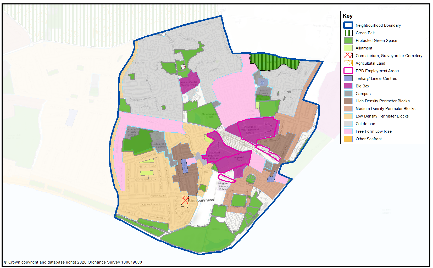
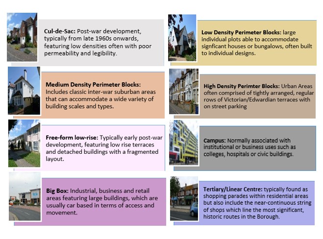
Map 54 shows the Urban Forms of Shoeburyness neighbourhood. This has been informed by the Southend Borough Wide Character Study and is intended to provide a broad overview of the types and densities of development across the neighbourhood; this can range from low density, areas of detached housing, to low rise flats.
To assist with the preparation of development management and design policies, which will impact the scale, type and density of new homes, we are interested in your views on broadly what types of development you think should come forward in the neighbourhood. It may be that there are different parts of the neighbourhood that you think could accommodate different types of development.
Figure 31 provides a range of development typologies at different densities, for both houses and flats. We’d like to know whether there is a particular typology that you’d like to see come forward in Shoeburyness and within the different Urbans Forms as shown in Map 54. For instance you may believe the medium density residential area within Map 54 should accommodate similar development, such as house typologies H2 and H3, and flat typology F1, within Figure 31.
Figure 31 - Development Typologies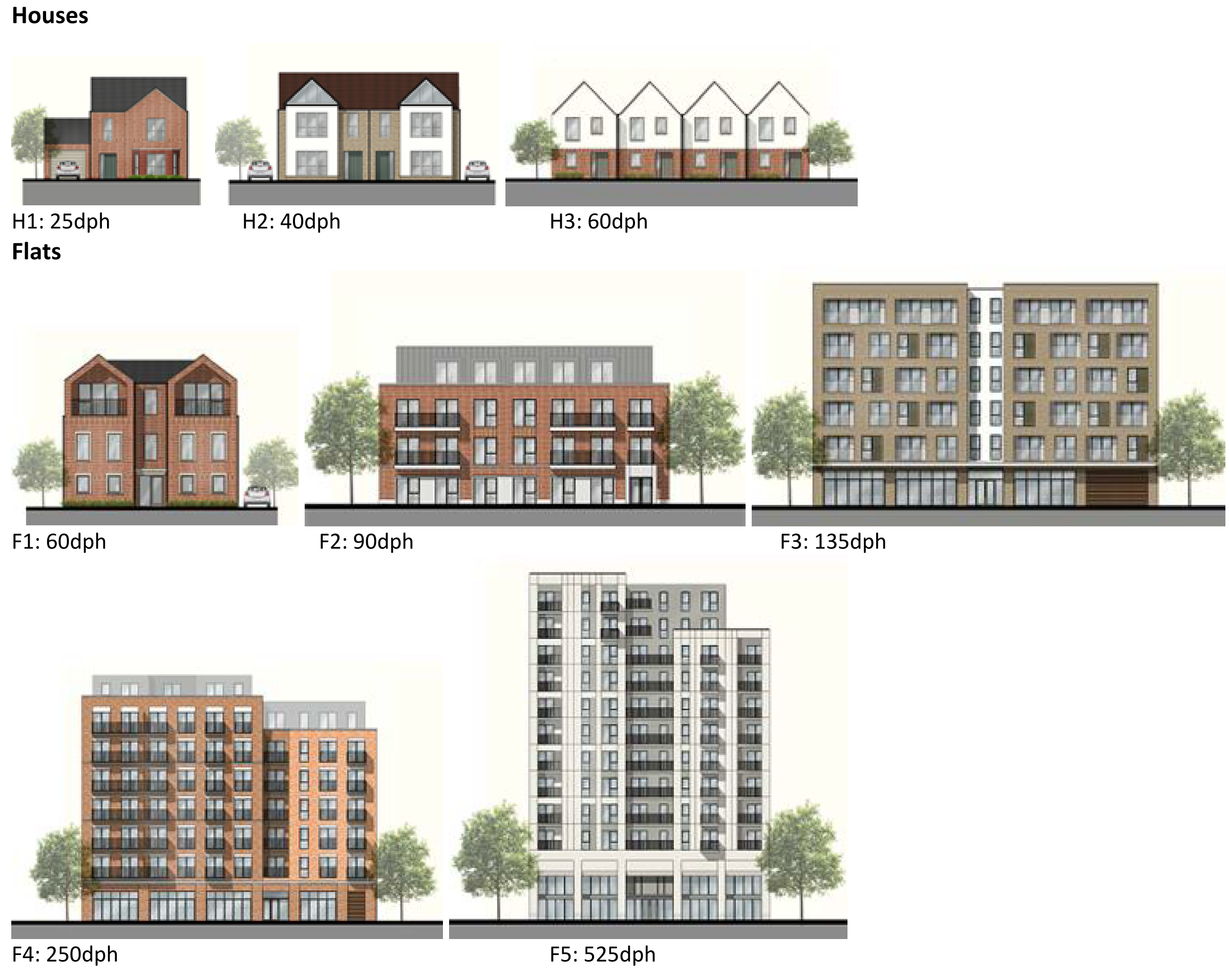
Map 54: Urban Form of Shoeburyness
Question 3.8.4.2 Urban Form
Have your say………
Please explain your answers
a. Are there development typologies (Figure 31) that you would like to see come forward in Shoeburyness? Please explain your answer – you may wish to refer to the different urban forms presented in Map 54 in your response.
To view our mapping feature showing Urban Forms: Southend-on-Sea Borough Council – Local Plan: Map 2 Urban Forms Map (opus4.co.uk)
3.8.4.3 Employment
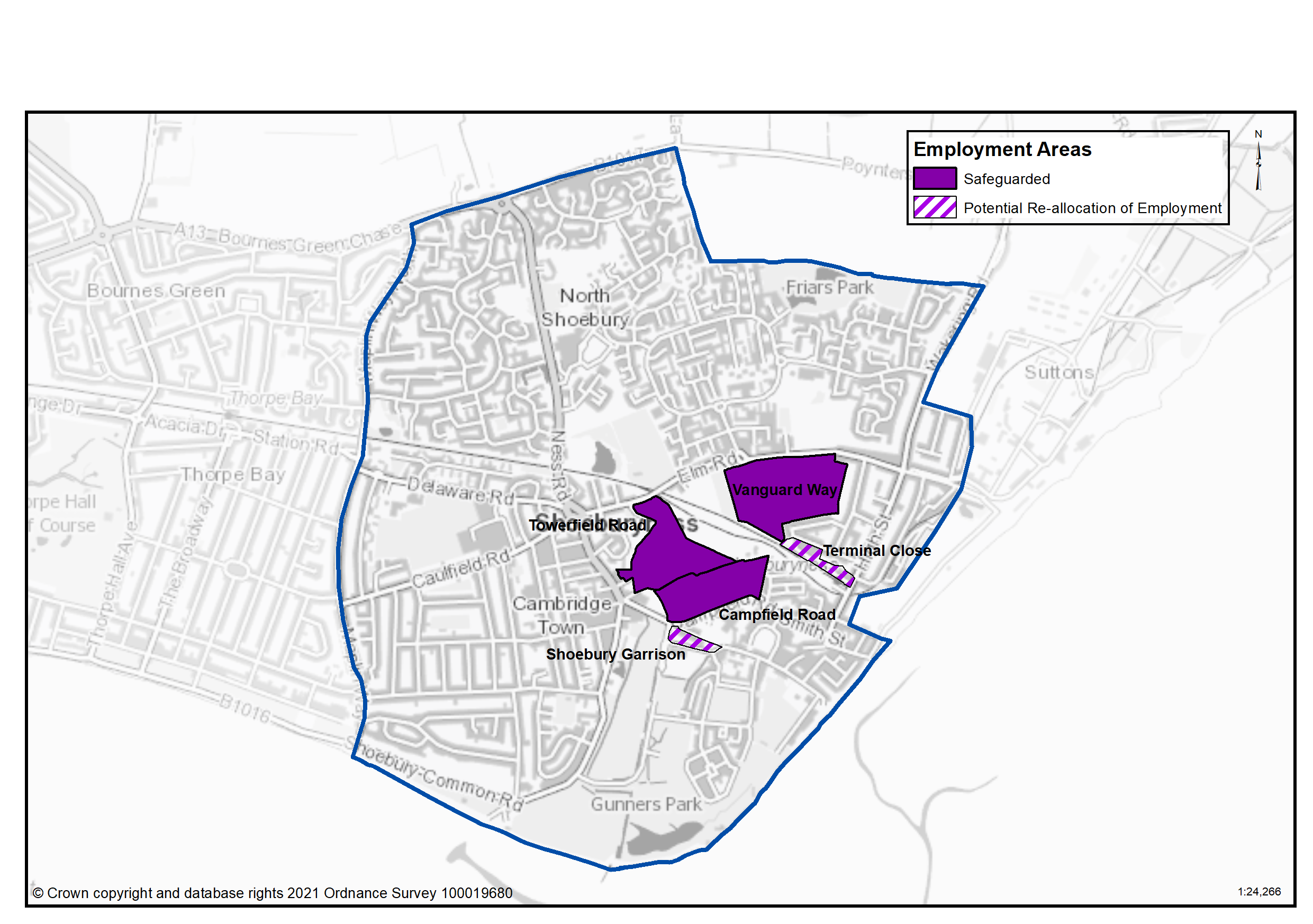
There are a number of industrial estates in Shoeburyness, largely clustered in the area close to the railway station and sidings. Vanguard Way, Towerfield Road and Campfield Road are particularly important locations offering a range of different sizes of units, from large format spaces accommodating major employers through to small business units such as the Seedbed Centre at Vanguard Way. It is intended they will be safeguarded for this purpose. Terminal Close and Shoebury Garrison Employment Areas may however offer opportunities for redevelopment for housing as they are currently functioning poorly as employment areas and have been identified for potential release. Terminal Close has a high vacancy rate and poor quality buildings, while Shoebury Garrison has lost most of its employment function to residential development and is likely to continue to do so as permissions have been granted for more residential development on other parts of the employment area. Table 49 and Map 55 sets out the employment land use proposals for Shoeburyness.
For businesses with regional and national markets, the location of Shoeburyness at the very end of the A13 creates access issues. It can take a considerable time at peak hours to negotiate traffic in Southend before reaching the Borough boundary. The proposed new Link Road offers the potential to improve accessibility to Shoebury’s employment areas.
Table 49: Land Use Proposals in Shoeburyness – Employment Land
|
Ref. No. |
Site Name |
Category |
Hectares |
Additional Floorspace |
|---|---|---|---|---|
|
|
Vanguard Way |
Safeguarded |
10.69 |
|
|
|
Towerfield Road |
Safeguarded |
7.25 |
|
|
|
Campfield Road |
Safeguarded |
6.13 |
|
|
|
Shoebury Garrison |
Re-allocation |
-1.49 |
|
|
|
Terminal Close |
Re-allocation |
-0.94 |
|
|
Total |
21.64 |
|
||
Map 55: Land Use Proposals in Shoeburyness – Employment Land
Question 3.8.4.3a Shoeburyness (Employment)
Have your say………
Please explain your answers
Question a. Do you agree that Vanguard Way should be safeguarded as a local employment site?
Question a. Do you agree that Towerfield Road should be safeguarded as a local employment site?
Question a. Do you agree that Campfield Road should be safeguarded as a local employment site?
Question a. Do you agree that Shoebury Garrison employment area should be re-allocated for residential led redevelopment?
Question a. Do you agree that Terminal Close employment area should be re-allocated for residential led redevelopment?
Question 3.8.4.3b Shoeburyness (Employment)
Question b. Do you have any other comments on employment land provision in Shoeburyess? If yes, please explain your answer.
3.8.4.4 Commercial Centres
To ensure the vitality of town centres, the National Planning Policy Framework encourages local planning authorities to implement planning policies and decisions that support the role that town centres play at the heart of local communities, by taking a positive approach to their growth, management, and adaptation.
The Government recently introduced changes to the Use Classes Order which consolidates a wide range of uses including retail, food, financial services, gyms, healthcare, nurseries, offices, and light industry into a single use class (Use Class E) and any change of use of a building or land between those uses falling within this Use Class will not require planning permission. It is therefore proposed to define as “Commercial Areas”, centres where we will promote ground floor uses to be within Class E Use Class and encourage improvements to shopfronts and the street scene.
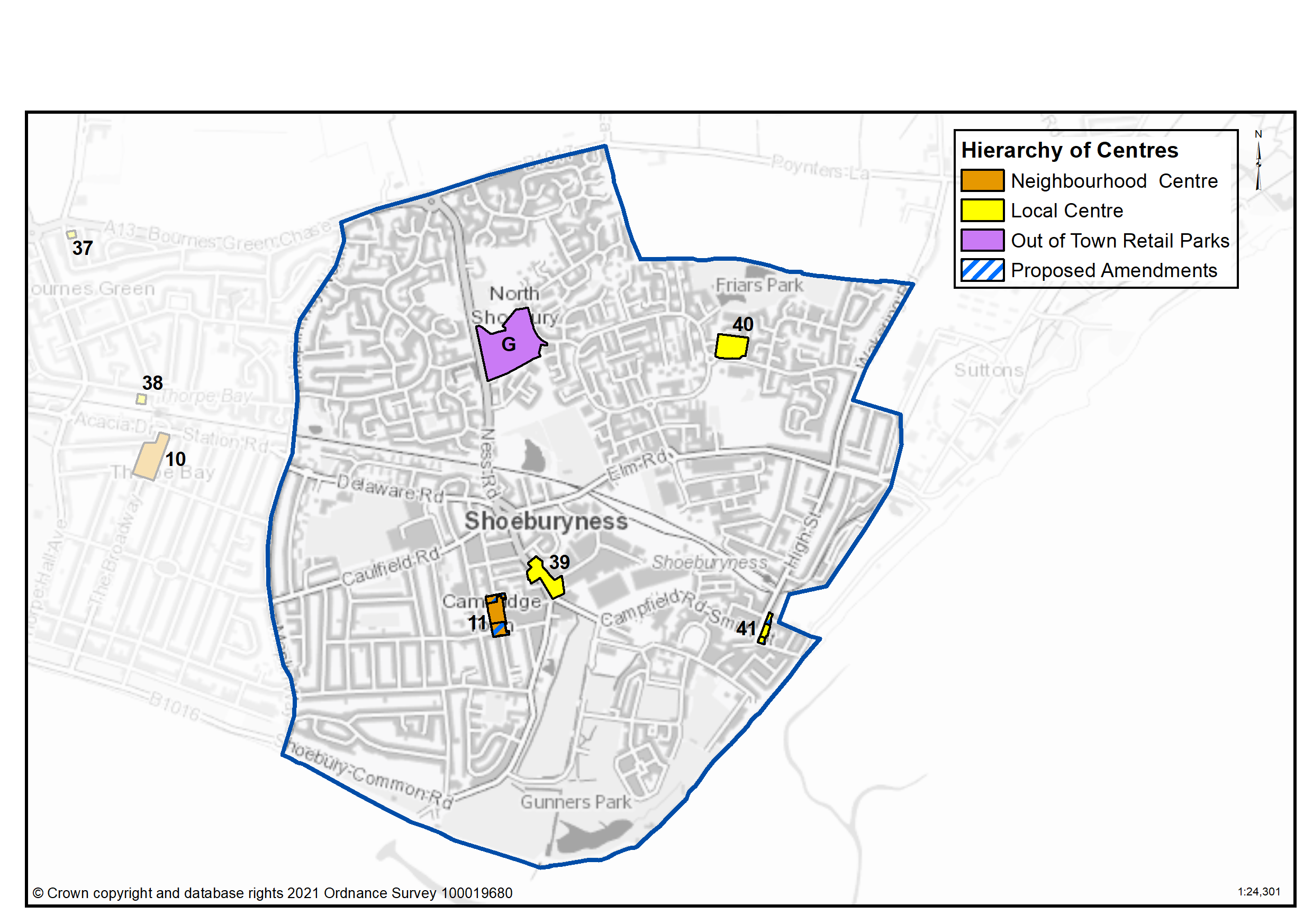
There are a range of commercial centres in the Borough that protect ground floor uses for business purposes (use class E7) and thereby perform a vital function by ensuring communities are served by a range of retail and commercial services. Those centres within Shoeburyness are outlined in Table 50 and Map 56.
As of August 2021, the Government is also introducing expanded permitted development rights to enable Commercial Uses to be converted to residential without planning permission. Due to this there are limitations on safeguarding ground floor commercial uses within key centres from changing to residential. However, under Article 4 of the General Permitted Development Order a local planning authority can apply to the Secretary of State to withdraw specified permitted development rights across a defined area. The use of Article 4 directions should not be expansive and therefore if we were to use them to restrict ground floor commercial uses from changing to residential, we must focus them to the most important frontages. In reference to Map 56 and Table 50 we are interested in your views on which centres we should investigate for using Article 4 Directions in order to restrict ground floor commercial frontages from being developed to residential under permitted development.
A number of amendments are proposed to de-designate parts of existing centres as shown in Map 56. These are in areas which either suffer from high vacancies or has lost a commercial frontage at ground floor level.
There are amendments proposed to the Shoeburyness (West Road) Neighbourhood Centre due to the reduction of active frontages in the north and south of the centre that reduce its ability to function as an effective Commercial, business and service sector. The northern section has a high vacancy rate while the southern section has a high proportion of units in residential use, introducing a dispersed distribution of commercial activities along these parts of the centre. To ensure a healthy commercial centre which delivers the required improvements and which functions accordingly it might be necessary to consider the extent of the centre by redefining and consolidating the areas dedicated to commercial activities to ensure a focused approach with emphasis on the areas located in the middle of the centre.
There are similar amendments also proposed to the High Street, Shoeburyness local centre due to a high proliferation of residential uses on the northern and southern parts of the centre.
Table 50: Shoeburyness Commercial Centres
|
Ref |
Name |
Centre Type |
|---|---|---|
|
11 |
Shoeburyness (West Road) |
Neighbourhood Centre |
|
39 |
Ness Road |
Local Centre |
|
40 |
The Renown |
Local Centre |
|
41 |
High Street, Shoeburyness |
Local Centre |
|
G |
North Shoebury |
Out of Town Retail Parks |
Map 56: Shoeburyness Commercial Centres
Question 3.8.4.4a Shoeburyness (Commercial Centres)
Have your say…….
Please explain your answer
Question a - Should we seek to define Shoeburyness (West Road) as a Neighbourhood Centre as set out in Table 50 to promote a range of commercial uses to serve local community needs and provide local employment opportunities?
Question a - Should we seek to define Ness Road as a Local Centre as set out in Table 50 to promote a range of commercial uses to serve local community needs and provide local employment opportunities?
Question a - Should we seek to define The Renown as a Local Centre as set out in Table 50 to promote a range of commercial uses to serve local community needs and provide local employment opportunities?
Question a - Should we seek to define High Street, Shoeburyness as a Local Centre as set out in Table 50 to promote a range of commercial uses to serve local community needs and provide local employment opportunities?
Question a - Should we seek to define North Shoebury as an Out of Town Retail Park as set out in Table 50 to promote a range of commercial uses to serve local community needs and provide local employment opportunities?
Question 3.8.4.4b Shoeburyness (Commercial Centres)
b. Should we investigate using Article 4 direction to safeguard ground floor commercial uses within the town, district and neighbourhood centres by restricting permitted development changes to residential – if yes, what frontages?
Question 3.8.4.4c Shoeburyness (Commercial Centres)
c. Do you agree with the proposed amendments to commercial centres as set out on Map 56?
Question 3.8.4.4d Shoeburyness (Commercial Centres)
d. Are there any other areas within the Shoeburyness Neighbourhood area that we haven’t identified that should be promoted for commercial activities at ground floor level? If yes, please explain your answer and let us know where.
3.8.4.5 Green Space
National planning policy allows for Local Plans to identify and protect existing green space so it is not built on unless an assessment demonstrates the open space, buildings or land are surplus to requirements; any open space lost would be replaced by equivalent or better provision in terms of quantity, quality and access; or the benefits of new sports and recreation facilities clearly outweigh the loss of the current or former use as open space. In this respect the New Local Plan seeks to protect the green spaces as set out in Table 51 and Map 57.
Existing Green Space
Shoebury Park, Friars Park, Gunners Park and East Beach are key areas of green space within the neighbourhood. Gunners Park has been re-configured as a result of the redevelopment of the Shoebury Garrison and is a large area of informal public space, including a pond, areas of natural open space, children’s play area, skateboard park and tennis courts. The areas of natural open space are managed by the Essex Wildlife Trust. The broader Garrison development includes a cricket field. Friars Park contains two ponds and a play area for older children. Other play spaces are located around the neighbourhood, such as off Caulfield Road. Tree canopy cover in the neighbourhood ranges from 8.6% of the ward in West Shoebury to 12.3% in Shoeburyness ward. This is set within the context of the Council’s Tree Policy which sets a target to extend the overall tree canopy cover in the Borough from 12% to 15% by 2050. Opportunities for enhancement of green space will be pursued wherever possible, especially around East Beach where management of day visitors will be particularly important.
Local Green Space
National planning policy allows local authorities to designate land as Local Green Space through their local plans, so that communities can identify and protect green areas of particular importance to them, for example because of its historic significance, recreational value, tranquillity, beauty or richness of its wildlife. Policies for managing Local Green Space are consistent with those for Green Belts.
Proposed Local Green Space – Gunners Park is proposed to be designated as a Local Green Space for its heritage and biodiversity value and unique character offering panoramic sea views. The outcome of this consultation will be particularly important in demonstrating that the space is special to the community.
Proposed New Green Space
It is proposed to designate the coastal walking and cycle link between East Beach and the Garrison estate as a Green Corridor. The potential new settlement to the north and west of Shoeburyness would include substantial amounts of greenspace linking into a broader South Essex Regional Park. This would include significant green corridors that would make access to countryside easier particularly by walking and cycling (Table 51a).
Falcon Way and Colne Drive are existing green spaces adjacent to Colne Drive playground which are proposed to be protected as Amenity Green Space. Other existing green spaces proposed to be protected as Amenity Green Space are Jena Close, Goya Rise and Hogarth Open Space. These informal spaces perform a valuable amenity, recreational and biodiversity role.
Existing playgrounds at Delaware Road, Jena Close and Caulfield Road are also proposed to be protected.
Green spaces with potential for other uses
Playing Fields at George Street and land at Elm Road which are currently protected as green space in the local plan have been identified as public land which has potential for development, including for housing (Table 51b).
Map 57 – Protected Green Space in Shoeburyness and Proposed Green Space
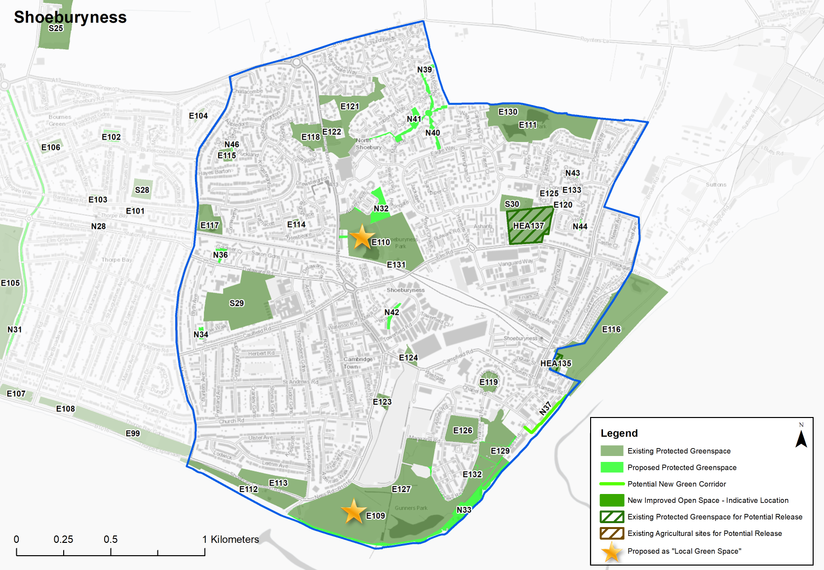
Table 51: Shoeburyness - Protected Green Space
|
Site Ref. |
Name of Site |
Size (Ha) |
|
Site Ref. |
Name of Site |
Size (Ha) |
|
Local Parks |
Playgrounds |
|||||
|
E109 |
Gunners Park |
28.235 |
E130 |
Friars Park |
0.402 |
|
|
E110 |
Shoebury Park |
9.261 |
E131 |
Shoebury Park Playground |
0.191 |
|
|
E111 |
Friars Park |
7.619 |
E132 |
Gunners Park - Toddler Play Area |
0.036 |
|
|
E112 |
Shoebury Common |
2.769 |
Pocket Park |
|||
|
E113 |
Shoebury Common North |
2.495 |
E133 |
Hogarth Drive Open Space |
0.026 |
|
|
Amenity Open Space |
School |
|||||
|
E114 |
Aylesbeare Open Space |
0.173 |
S29 |
Shoebury High playing fields |
7.646 |
|
|
E115 |
Cheldon Barton Open Space |
0.365 |
S30 |
Friars Primary School Playing fields |
1.206 |
|
|
E116 |
East Beach Open Space |
12.735 |
Allotments |
|||
|
E117 |
Maplin Way Open Space |
1.574 |
A12 |
Growing Together Shoeburyness |
0.349 |
|
|
E118 |
Sedgemoor Open Space |
1.900 |
A13 |
Elm Road/Towerfield Road |
0.577 |
|
|
E119 |
Horseshoe Crescent |
0.838 |
A14 |
Herbert Road |
0.460 |
|
|
E120 |
Whistler Rise Open Space |
0.044 |
A15 |
St Andrews Road |
0.821 |
|
|
E121 |
St Mary's Green |
4.011 |
Crematorium, Graveyard or Cemetry |
|||
|
E122 |
St Mary's Nature Reserve |
0.975 |
C10 |
St Mary's, Shoebury |
0.258 |
|
|
E123 |
Ness Road |
0.448 |
C11 |
St Andrews |
0.975 |
|
|
E124 |
Campfield Road War Memorial |
0.422 |
Release Site |
|||
|
E125 |
Turner Close Courtyard |
0.041 |
HEA135 |
Part of playing field George Street |
0.318 |
|
|
Sports Grounds |
HEA137 |
Land at Elm Road Sports Ground |
3.880 |
|||
|
E126 |
Garrison Cricket Square |
2.186 |
|
|||
|
E127 |
Gunners Park - Wheeled Sports |
0.034 |
||||
|
E128 |
Gunners Park - Ball Sports |
0.032 |
||||
|
E129 |
Gunners Park - Tennis Courts |
0.124 |
||||
Sites in bold are proposed as ‘Local Green Space’
Table 51a: Shoeburyness – Proposed Green Space
Individual Sites listed below with questions
Table 51b: Land Use Proposals in Shoeburyness – Green Space Currently Protected but with potential for release
Individual Sites listed below with questions
Question 3.8.4.5a Shoeburyness (Green Space)
Have your say………
Please explain your answers
N32...Shoebury Park Expansion
Local Parks
Site Ref - N32
Name of Site - Shoebury Park Expansion
Size (Ha) - 1.184
Question a - Do you agree with this proposed new green space designation?
N33...Gunners Park update to boundary
Local Parks
Site Ref - N33
Name of Site - Gunners Park update to boundary
Size (Ha) - 3.061
Question a - Do you agree with this proposed new green space designation?
N34...Caulfield Road (Wicklow Walk)
Playgrounds
Site Ref - N34
Name of Site - Caulfield Road (Wicklow Walk)
Size (Ha) - 0.161
Question a - Do you agree with this proposed new green space designation?
N35...Jena Close Playground
Playgrounds
Site Ref - N35
Name of Site - Jena Close Playground
Size (Ha) - 0.038
Question a - Do you agree with this proposed new green space designation?
N36...Delaware Road
Playgrounds
Site Ref - N36
Name of Site - Delaware Road
Size (Ha) - 0.295
Question a - Do you agree with this proposed new green space designation?
N37...East Beach path to Gunners Park
Green Corridor
Site Ref - N37
Name of Site - East Beach path to Gunners Park
Size (Ha) - 315m
Question a - Do you agree with this proposed new green space designation?
N38...Colne Drive Sports Ground
Sports Ground
Site Ref - N38
Name of Site - Colne Drive Sports Ground
Size (Ha) - 0.026
Question a - Do you agree with this proposed new green space designation?
N39...Collingwood Open Space
Local Parks
Site Ref - N39
Name of Site - Collingwood Open Space
Size (Ha) - 0.450
Question a - Do you agree with this proposed new green space designation?
N40...Falcon Way Open Space
Amenity Open Space
Site Ref - N40
Name of Site - Falcon Way Open Space
Size (Ha) - 0.557
Question a - Do you agree with this proposed new green space designation?
N41...Colne Drive Open Space
Amenity Open Space
Site Ref - N41
Name of Site - Colne Drive Open Space
Size (Ha) - 0768
Question a - Do you agree with this proposed new green space designation?
N42...Jena Close Open Space
Amenity Open Space
Site Ref - N42
Name of Site - Jena Close Open Space
Size (Ha) - 0.238
Question a - Do you agree with this proposed new green space designation?
N43...Goya Rise Open Space
Amenity Open Space
Site Ref - N43
Name of Site - Goya Rise Open Space
Size (Ha) -0.082
Question a - Do you agree with this proposed new green space designation?
N44...Hogarth Open Space
Amenity Open Space
Site Ref - N44
Name of Site - Hogarth Open Space
Size (Ha) - 0.066
Question a - Do you agree with this proposed new green space designation?
N45...Aylesbeare Open Space Extension
Amenity Open Space
Site Ref - N45
Name of Site - Aylesbeare Open Space Extension
Size (Ha) - 0.033
Question a - Do you agree with this proposed new green space designation?
N46...Cheldon Barton Open Space Extension
Amenity Open Space
Site Ref - N46
Name of Site - Cheldon Barton Open Space Extension
Size (Ha) - 0.035
Question a - Do you agree with this proposed new green space designation?
Question 3.8.4.5b Shoeburyness (Green Space)
b. Are there any other areas we haven’t identified that should be protected or promoted for green infrastructure? If yes, please provide an address.
Question 3.8.4.5c Shoeburyness (Green Space)
HEA135...Land at George Street
Green Space Currently Protected but with potential for release
Site Ref - HEA135
Name of Site - Land at George Street
Size (Ha) - 0.32
Description - Former playing field associated with Hinguar School, about 0.5 miles from site.
Quality/Condition - Grassed playing field, maintained. Fenced off and sign states “for school use only”. Green space to north and east is publicly accessible and functionally part of East Beach recreation area.
Area of Deficiency Y/N? N
Potential Housing Capacity (net) - 16
Justification - Land is in public ownership and has potential for residential development. Redevelopment could enhance adjacent green space.
Question c - Do you agree with the proposal to release this site from green space designation?
HEA137...Land at Elm Road
Green Space Currently Protected but with potential for release
Site Ref - HEA137
Name of Site - Land at Elm Road
Size (Ha) - 3.77
Description - Former landfill site.
Quality/Condition - Contamination issues, land actively managed for biodiversity, used by dog walkers/pedestrian link through area.
Area of Deficiency Y/N? Possible if removed in entirety
Potential Housing Capacity (net) - 300
Justification - Land is in public ownership and has potential for residential development
Question c - Do you agree with the proposal to release this site from green space designation?
Question 3.8.4.5d Shoeburyness (Green Space)
E109...Gunners Park
Local Parks
Site Ref - E109
Name of Site - Gunners Park
Size (Ha) - 28.235
Sites proposed as ‘Local Green Space'
Question d - Do you agree with Gunners Park being identified as Local Green Space?
E110...Shoebury Park
Local Parks
Site Ref - E110
Name of Site - Shoebury Park
Size (Ha) - 9.261
Sites proposed as ‘Local Green Space'
Question d - Do you agree with Gunners Park being identified as Local Green Space?
Question 3.8.4.5e Shoeburyness (Green Space)
Question e - Are there any other sites within Shoeburyness that should be designated as Local Green Space? If yes, please provide an address and supporting evidence to outline how the space is special to local community in terms of beauty, historic significance, recreational value, tranquillity, wildlife or is special to the local community for other reasons
Question 3.8.4.5f Shoeburyness (Green Space)
Question f - Do you have any other other comments on green space provision in Shoeburyness? If yes, please explain your answer.
6 nurseries, primary schools, secondary schools, doctors, dentists, pharmacies, libraries, places of worship, public conveniences, community centres and halls, playing pitches, local equipped play space, amenity greenspace, allotments, natural and semi-natural greenspace, local and neighbourhood centres, town and district centres