3.4.1 General Character
You may also wish to refer to Section 2.5: Town Centre and Central Seafront of the Local Plan, which includes a draft vision and other potential provisions for the area.
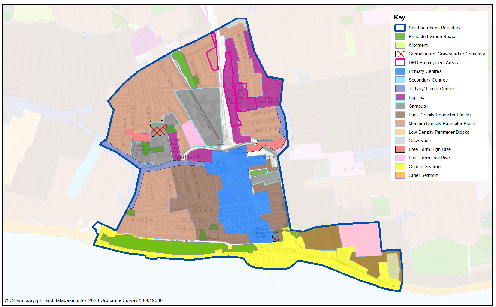
Southend Central (Map 31, Figure 21) comprises the town centre and central seafront and is characterised by four distinct quarters, alongside surrounding residential areas, namely:
- Town Centre – a sub-regional retail centre, dominated by comparison shopping including two retail malls at the northern and southern ends of the pedestrianised High Street. The area also includes high rise residential tower blocks and parades of shops, some with residential accommodation above. The Forum accommodates the public library and art gallery that is next to part of the University of Essex and South Essex College campuses. The town centre is the principal public transport hub for the Borough and includes two railway stations (Central and Victoria) and the bus station/travel centre interchange. The Kenway/Short Street area to the north of the High Street includes elements of employment land, as well as a range of residential development including the Queensway flatted developments and some more suburban type terraced housing. The Warrior Square Conservation Area to the east of the High Street is a residential community set around tree-lined open space.
- Milton and Clifftown – these areas mark the early expansion of Southend’s residential neighbourhoods and form an historic core with some particularly attractive planned streets and spaces, including the Prittlewell Square and Westcliff/Clifftown Parade Gardens. Much of the area is designated as a Conservation Area (Clifftown and Milton Conservation Areas).
- Civic Quarter – a grouping of a number of bulky post-war civic buildings, including the Civic Centre, Police Station, Courts, Art Gallery and Museum on the eastern side of Victoria Avenue. The opposite side of Victoria Avenue has now seen the conversion of a number of obsolete large office blocks into residential use, some with active commercial uses at ground floor. This area also includes the sunken gardens of Churchill Gardens providing a tranquil green setting to the north of the Civic Quarter, and part of the Prittlewell Conservation Area.
- Central Seafront – includes an extensive range of leisure and tourism functions focussed along Western Esplanade and Marine Parade including the historic Pier, Kursaal and Adventure Island. The City Beach (Phase 1) scheme has revitalised a key part of the central seafront, with key enhancements made to the public realm. Economic impact assessments show that the tourism and leisure facilities attract over 7 million day visitors2 and a quarter of a million staying visitors to the area each year. The cliffs along Western Esplanade provide a green backdrop to the seafront with the Cliffs Pavilion, a major regional theatre, situated at its western end. To the east of the neighbourhood is the post-war Kursaal estate comprising terraced housing and flats, and the Grade II listed Kursaal building (part of the Kursaal Conservation Area) with Eastern Esplanade also providing a focus for leisure and tourism, as well as being home to the Eastern Esplanade Conservation Area.
There are a number of major issues and challenges facing the town centre and central seafront area over the coming years. These include the significant decline in the High Street’s traditional comparison goods retail function in the face of increasing on-line shopping competition and the need to regenerate the area, building on its significant tourism, cultural and leisure potential. However, the Southend Retail Study3 highlighted the potential demand for additional convenience retailing in the town centre and the growth potential of the food and drink sector. The Better Queensway project is seeking to regenerate the area to the north east of the High Street as a residential led community project which will be better integrated with the town centre.
With good accessibility by road, rail and bus combined with supporting services and facilities, there are a number of opportunities for new housing development at higher densities within the neighbourhood that will contribute to the regeneration and vitality of the neighbourhood and to meeting a range of local housing needs.
Map 31: Southend Central Characteristics
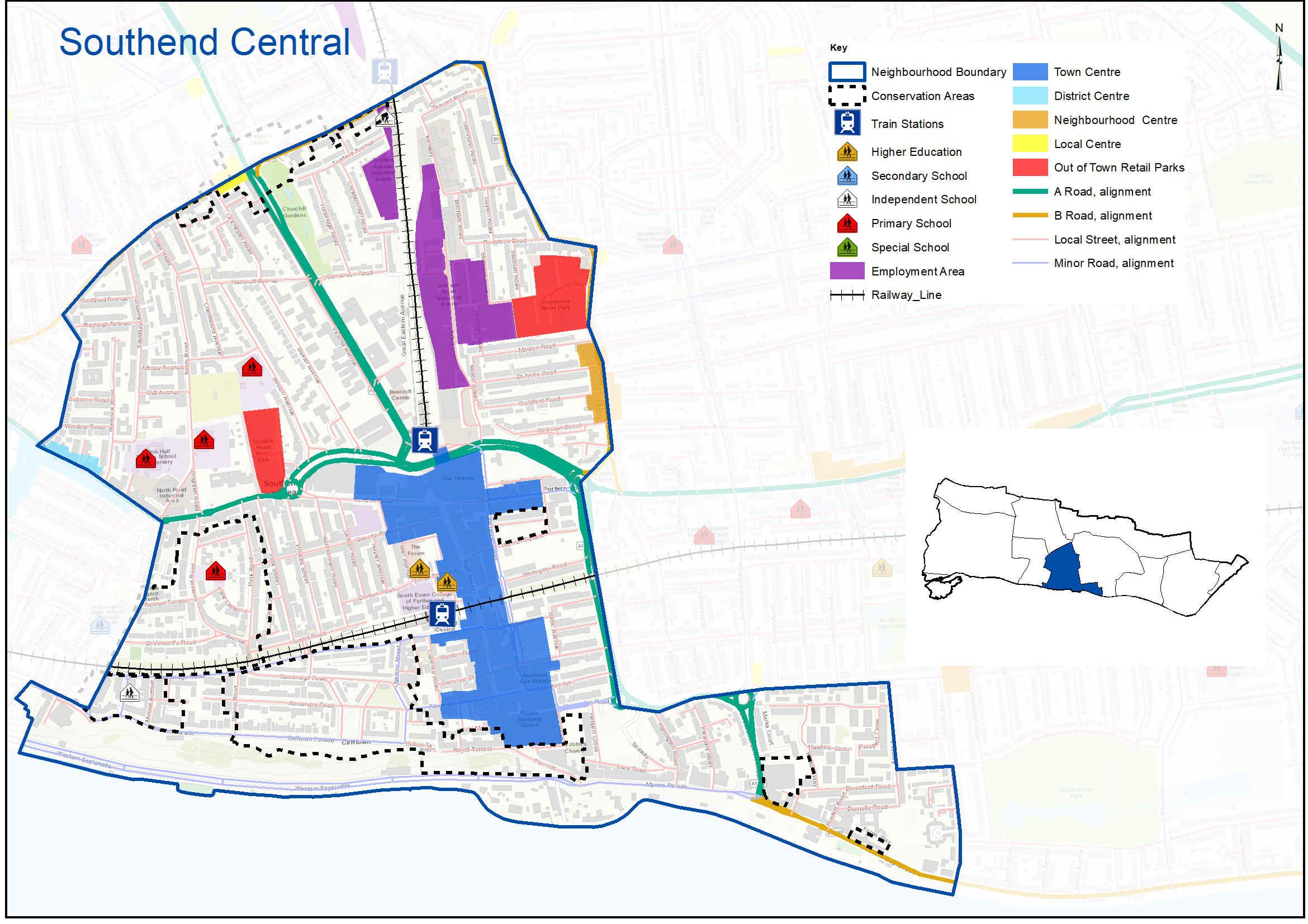
Figure 21: Southend Central Characteristics
|
No. Homes |
Density |
Land Area (ha) |
Car Ownership per home |
|
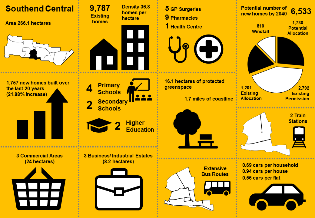
9,787 |
36.8dph |
266.1 |
0.69 |
3.4.2 Complete Neighbourhoods (accessibility to services and facilities)
The following profile seeks to build up a picture of the ‘completeness’ of Southend Central. Completeness is based on mapping the walking catchments around different day to day facilities (17 different facilities in total) 4. The catchment areas vary by facility and reflect comfortable walking distances for the average, able-bodied person. The catchments are based on actual walking routes rather than ‘as the crow flies’ distances.
A high completeness score means a place has lots of facilities the community needs within an easy walking distance. This approach recognises the important links to health and social well-being, community cohesion and inclusion.
The completeness score for Southend Central, by infrastructure type, is summarised in the rainbow image below. For example 90% of the neighbourhood lies within easy walking distance to a health facility, 51% of the neighbourhood is within easy walking distance of sports and leisure facilities, while 18% is within an easy walk of green space.
Please refer to Section 2.5: Town Centre and Central Seafront to view and comment on a draft vision, existing allocations set out in the Southend Central Area Action Plan (SCAAP), and other potential opportunity sites and interventions for Southend Central.
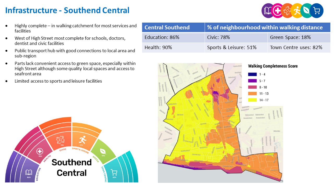
Southend Central ‘Aggregated Completeness Score’ = 68%
Map – as an example a high completeness score would be 14 –17 different facilities being within a reasonable walking distance from home. Conversely a low score would be less than 4 facilities within walking distance.
Question 3.4.2 Southend Central (Infrastructure)
Have your say…….
Please explain your answer
a. Are there any issues with infrastructure provision in Southend Central? Please explain your answer and let us know what the priorities should be over the next 20 years.
3.4.3 Planned Changes: Land Use Proposals
In addition to the SCAAP Opportunity Sites, new land use proposals are identified for future housing, employment and green space within the Southend Central neighbourhood as set out below.
3.4.3.1 New Homes
The type and quality of the housing offer can have a significant impact on the health and wealth of places. Their ability to attract and retain people and provide support for those who need it relies on good housing and attractive and inclusive neighbourhoods.
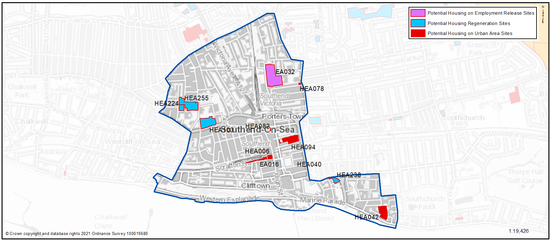
Potential site proposals for residential development are set out in Map 32 and Table 32. These have been promoted to us by landowners/ agents and are included here for comment. The sites are in addition to sites that are already allocated within the SCAAP (as set out above) or have planning permission.
For more information on each site an assessment can be viewed by clicking on the link reference in the various tables below or via: Appendix 4: Site Proformas | Southend Local Plan.
Map 32: Potential Residential Sites – Southend Central (excluding those with planning permission)
Please refer to Section 2.5: Town Centre and Central Seafront to view sites already allocated for development as part of the SCAAP
Table 32: Residential Sites – Southend Central
Question 3.4.3.1a Southend Central (Housing)
HEA006...Central House, Clifftown Road
HEA006
Context/ Surrounding Uses - A 6 Storey building located on the northern side of Clifftown Road, adjacent to Southend Central Railway Station, where it intersects with the High Street. The building contains a retail unit and offices at ground floor and car parking. The surrounding area is commercial in character.
Potential Land Use - Part of this major site has planning permission for 28 dwellings
Potential Land Use Summary - Residential development
Component Change - Urban Area General
Estimated Number of Homes gross 170 - Net 170
| https://localplan.southend.gov.uk/sites/localplan.southend/files/2021-08/Southend%20Central%20Proformas.pdf#page=5 |
Have your say………
Please explain your answers
Question a - Do you agree with with the potential proposals for this site? Please explain your answer. You may wish to outline the type and scale of development you would like to see come forward in reference to Figure 22: Development Typologies
Question 3.4.3.1a Southend Central (Housing)
HEA040...57 York Road
HEA040
Context/ Surrounding Uses - A 3 storey building located on the northern side of York Road near the junction with Baltic Avenue. Surrounding properties are similar in terms of form and style. The site is located within a predominantly residential area.
Potential Land Use - This site has potential for 5 dwellings
Potential Land Use Summary - Residential development
Component Change - Urban Area General
Estimated Number of Homes gross 5 - Net 4
| https://localplan.southend.gov.uk/sites/localplan.southend/files/2021-08/Southend%20Central%20Proformas.pdf#page=6 |
Question a - Do you agree with with the potential proposals for this site? Please explain your answer. You may wish to outline the type and scale of development you would like to see come forward in reference to Figure 22: Development Typologies
Question 3.4.3.1a Southend Central (Housing)
HEA042...Former Gas Works, Eastern Esplanade
HEA042
Context/ Surrounding Uses - The site is located on the north side of Eastern Esplanade, also fronting Burnaby Road to the north. The site has now been cleared and laid out for temporary public parking. The site falls within the SCAAP Central Seafront Policy Area. The surrounding uses are largely residential of between 2 to 5 storey (flats and houses), however there is also a 5 storey Premier Inn hotel to the east of the site.
Potential Land Use - The site is considered suitable for a major mixed-use scheme that could include public parking.
Potential Land Use Summary - Residential development
Component Change - Urban Area General
Estimated Number of Homes gross 216 - Net 216
| https://localplan.southend.gov.uk/sites/localplan.southend/files/2021-08/Southend%20Central%20Proformas.pdf#page=7 |
Question a - Do you agree with with the potential proposals for this site? Please explain your answer. You may wish to outline the type and scale of development you would like to see come forward in reference to Figure 22: Development Typologies
Question 3.4.3.1a Southend Central (Housing)
HEA048...215-215a North Road
HEA048
Context/ Surrounding Uses - The site is located on the western side of North Rd. It is boarded up and the previous buildings have been demolished. The streetscene in this part of North Road is predominantly made up of two storey residential properties.
Potential Land Use - Small site with potential for 9 dwellings.
Potential Land Use Summary - Residential development
Component Change - Urban Area General
Estimated Number of Homes gross 9 - Net 9
| https://localplan.southend.gov.uk/sites/localplan.southend/files/2021-08/Southend%20Central%20Proformas.pdf#page=8 |
Question a - Do you agree with with the potential proposals for this site? Please explain your answer. You may wish to outline the type and scale of development you would like to see come forward in reference to Figure 22: Development Typologies
Question 3.4.3.1a Southend Central (Housing)
HEA078...Styles Properties, 165 Sutton Rd
HEA078
Context/ Surrounding Uses - The site is located on the western side of Sutton Road, at the junction with Maldon Road. It was previously occupied by a single storey industrial building, and is stepped, taking into account of the changing levels on Maldon Road. Site is now vacant. There is a varied street scene in this location with a mixture of both residential and commercial uses.
Potential Land Use - Potential for a residential-led, mixed-use scheme with retention of some commercial use at ground floor on Sutton Road.
Potential Land Use Summary - Residential development
Component Change - Urban Area General
Estimated Number of Homes gross 7 - Net 7
| https://localplan.southend.gov.uk/sites/localplan.southend/files/2021-08/Southend%20Central%20Proformas.pdf#page=9 |
Question a - Do you agree with with the potential proposals for this site? Please explain your answer. You may wish to outline the type and scale of development you would like to see come forward in reference to Figure 22: Development Typologies
Question 3.4.3.1a Southend Central (Housing)
HEA082...Commercial Premises, 4 Southchurch Road
HEA082
Context/ Surrounding Uses - This site includes a 3-storey building located to the rear of Southchurch Road, overlooking a service deeping adjacent to the main High Street and Victoria Shopping Centre. The building includes commercial frontage, the middle floor and upper floor are in use as offices. There is an expired permission on the site for a part 4/part 5 storey building comprising 24 flats with a restaurant at ground floor.
Potential Land Use - Residential led scheme with commercial ground floor.
Potential Land Use Summary - Residential development
Component Change - Urban Area General
Estimated Number of Homes gross 24 - Net 24
| https://localplan.southend.gov.uk/sites/localplan.southend/files/2021-08/Southend%20Central%20Proformas.pdf#page=10 |
Question a - Do you agree with with the potential proposals for this site? Please explain your answer. You may wish to outline the type and scale of development you would like to see come forward in reference to Figure 22: Development Typologies
Question 3.4.3.1a Southend Central (Housing)
HEA094...Land at Warrior Square
HEA094
Context/ Surrounding Uses - The site currently includes surface parking areas, skate park and a central grassed area. The site was previously occupied by an indoor swimming pool. The proposed site does not include a 2-storey building in use as offices in the north west corner. A terrace of Victorian 2-storey dwellings sits directly adjacent the site to the south west of site. Warrior Square open space and more terraced housing is located to the north (designated Conservation Area) and further terraced dwellings to south. Part of the site is occupied by a skate park.
Potential Land Use - Likely to be suitable for a residential-led mixed-use scheme. Any redevelopment would need to consider the recently installed skate park.
Potential Land Use Summary - Residential led development that may include re-provision of public parking, linked to additional parking provision at Tylers Avenue (see Table 30)
Component Change - Urban Area General
Estimated Number of Homes gross 300 - Net 300
| https://localplan.southend.gov.uk/sites/localplan.southend/files/2021-08/Southend%20Central%20Proformas.pdf#page=11 |
Question a - Do you agree with with the potential proposals for this site? Please explain your answer. You may wish to outline the type and scale of development you would like to see come forward in reference to Figure 22: Development Typologies
Question 3.4.3.1a Southend Central (Housing)
HEA122...Warrior House, 42 - 82 Southchurch Road
HEA122
Context/ Surrounding Uses - Located to south side of Southchurch Road and to the west of Warrior Square East. Contains a three storey commercial building. Surrounded by predominantly 2/3 storey buildings, with commercial ground floor, some with residential above. Queensway dual carriageway is to the east, Warrior Square Conservation Area is to the south, the town centre is to the west, the Better Queensway site is to the north.
Potential Land Use - Conversion of upper floors to residential use.
Potential Land Use Summary - Residential development
Component Change - Urban Area General
Estimated Number of Homes gross 15 - Net 15
| https://localplan.southend.gov.uk/sites/localplan.southend/files/2021-08/Southend%20Central%20Proformas.pdf#page=13 |
Question a - Do you agree with with the potential proposals for this site? Please explain your answer. You may wish to outline the type and scale of development you would like to see come forward in reference to Figure 22: Development Typologies
Question 3.4.3.1a Southend Central (Housing)
HEA103...Nazareth House, 111 London Rd
HEA103
Context/ Surrounding Uses - Located on the north side of the London Road, the former care home and associated accommodation, surrounded by garden/amenity space, with a tall brick wall running around the edge of the site. The area to the south of London Road is predominantly two storeys, commercial ground floor, with Milton Conservation Area further to the south. To the north the area includes two schools and tower blocks/ residential streets beyond. A new flatted residential scheme lies to the west.
Potential Land Use - Residential development that maintains a good level of garden/ amenity space.
Potential Land Use Summary - Residential development
Component Change - Housing Regeneration Sites
Estimated Number of Homes gross 150 - Net 80
| https://localplan.southend.gov.uk/sites/localplan.southend/files/2021-08/Southend%20Central%20Proformas.pdf#page=12 |
Question a - Do you agree with with the potential proposals for this site? Please explain your answer. You may wish to outline the type and scale of development you would like to see come forward in reference to Figure 22: Development Typologies
Question 3.4.3.1a Southend Central (Housing)
HEA224...Buckingham House, Salisbury Avenue
HEA224
Context/ Surrounding Uses - Part 1 and 2 storey building currently occupied as sheltered housing. Located in a residential area adjacent to residential tower blocks and a community centre.
Potential Land Use - Existing building in public ownership that may benefit from some renewal, redevelopment or expansion that could provide new and better quality homes that are designed to be adaptable so local people can reside independently through all stages of their lives. To gain a comprehensive understanding of development potential, all existing housing estates in public ownership have been included for comment. At the time of publication of this document no Council decision has been made on redeveloping this site.
Potential Land Use Summary - Residential development
Component Change - Housing Regeneration Sites
Estimated Number of Homes gross 68 - Net 40
| https://localplan.southend.gov.uk/sites/localplan.southend/files/2021-08/Southend%20Central%20Proformas.pdf#page=14 |
Question a - Do you agree with with the potential proposals for this site? Please explain your answer. You may wish to outline the type and scale of development you would like to see come forward in reference to Figure 22: Development Typologies
Question 3.4.3.1a Southend Central (Housing)
HEA238...Norman Harris House, 450 Queensway
HEA238
Context/ Surrounding Uses - Part 4 and 3 storey building currently in use as sheltered accommodation. In a prominent location fronting the A1160 onto a roundabout. Green space to the rear with car parking to the west.
Potential Land Use - Existing building in public ownership that may benefit from some renewal, redevelopment or expansion that could provide new and better quality homes that are designed to be adaptable so local people can reside independently through all stages of their lives. To gain a comprehensive understanding of development potential, all existing housing estates in public ownership have been included for comment. At the time of publication of this document no Council decision has been made on redeveloping this site.
Potential Land Use Summary - Residential development
Component Change - Housing Regeneration Sites
Estimated Number of Homes gross 63 - Net 35
| https://localplan.southend.gov.uk/sites/localplan.southend/files/2021-08/Southend%20Central%20Proformas.pdf#page=15 |
Question a - Do you agree with with the potential proposals for this site? Please explain your answer. You may wish to outline the type and scale of development you would like to see come forward in reference to Figure 22: Development Typologies
Question 3.4.3.1a Southend Central (Housing)
HEA255...Blackdown, Brecon & Grampian
HEA255
Context/ Surrounding Uses - Residential estate comprising three 16 storey towers, a community centre, garages and landscaped area. Surrounded by generally low-rise residential area with site adjacent to a primary school.
Potential Land Use - Existing building in public ownership that may benefit from some renewal, redevelopment or expansion that could provide new and better quality homes that are designed to be adaptable so local people can reside independently through all stages of their lives. To gain a comprehensive understanding of development potential, all existing housing estates in public ownership have been included for comment. At the time of publication of this document no Council decision has been made on redeveloping this site.
Potential Land Use Summary - Residential development
Component Change - Housing Regeneration Sites
Estimated Number of Homes gross 309 - Net 78
| https://localplan.southend.gov.uk/sites/localplan.southend/files/2021-08/Southend%20Central%20Proformas.pdf#page=16 |
Question a - Do you agree with with the potential proposals for this site? Please explain your answer. You may wish to outline the type and scale of development you would like to see come forward in reference to Figure 22: Development Typologies
Question 3.4.3.1a Southend Central (Housing)
EA016...Central Station, Clifftown Road
EA016
Context/ Surrounding Uses - The railway line is to the north of the site, college/university buildings beyond this. The High Street lies to the east, with commercial and residential uses to the south. The Site includes a range of uses including parking and a commercial garage. The Southend Central Station is locally listed and presently has a low quality forecourt. Was previously allocated in the Borough Local Plan (1994) but has not come forward.
Potential Land Use - Redevelopment could bring about associated public realm enhancements, improving setting of station and access to it. The site could be appropriate for office use or alternatively, comprehensive regeneration to include the station and residential uses could be considered.
Potential Land Use Summary - Residential development
Component Change - Urban Area General
Estimated Number of Homes gross 200 - Net 200
Question a - Do you agree with with the potential proposals for this site? Please explain your answer. You may wish to outline the type and scale of development you would like to see come forward in reference to Figure 22: Development Typologies
Question 3.4.3.1a Southend Central (Housing)
EA032...Grainger Close Employment Area
EA032
Context/ Surrounding Uses - The site is currently protected as an Industrial estate but has been identified for potential release. Surrounding uses are a mix of residential and other commercial buildings. Grainger Road cuts through the site.
Potential Land Use - Located within a suitable area for housing (if allocated) but has unknown availability. The site appears to be in multiple ownerships and may require assembly.
Potential Land Use Summary - Residential development
Component Change - Employment Release Site
Estimated Number of Homes gross 552 - Net 552
Question a - Do you agree with with the potential proposals for this site? Please explain your answer. You may wish to outline the type and scale of development you would like to see come forward in reference to Figure 22: Development Typologies
Question 3.4.3.1b Southend Central (Housing)
Question b. Do you have any other comments on housing provision in Southend Central? If yes, please explain your answer.
3.4.3.2 Urban Form and Broad Development Typologies
Good quality urban design will be essential in new housing development if the character of the neighbourhood is to be enhanced. New development will need to be imaginative and dynamic in its design reflecting its central location.
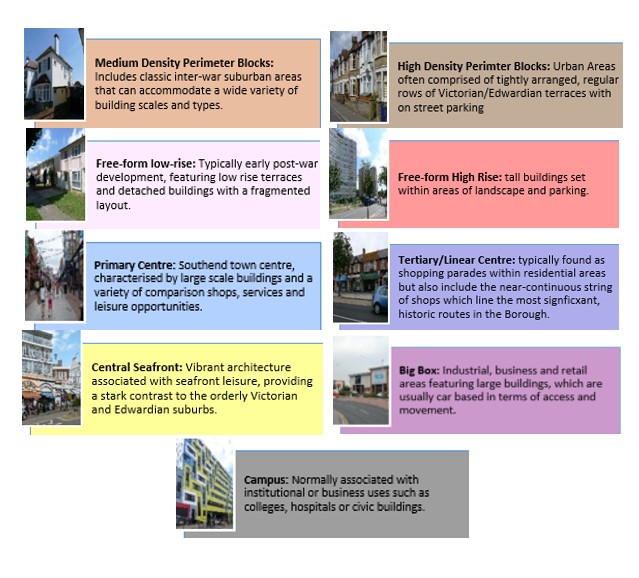
Map 33 shows the Urban Forms of Southend Central neighbourhood. This has been informed by the Southend Borough Wide Character Study and is intended to provide a broad overview of the types and densities of development across the neighbourhood; this can range from low density, areas of detached housing, to high rise flats.
To assist with the preparation of development management and design policies, which will impact the scale, type and density of new homes, we are interested in your views on broadly what types of development you think should come forward in the neighbourhood. It may be that there are different parts of the neighbourhood that you think could accommodate different types of development.
Figure 22 provides a range of development typologies at different densities, for both houses and flats. We’d like to know whether there is a particular
typology that you’d like to see come forward in Southend Central and within the different Urbans Forms as shown in Map 33. For instance you may believe the ‘Primary Centre’ and ‘Campus’ areas within Map 33 should accommodate the highest density development, such as flats typology F5 and F6, within Figure 22.
The Council’s adopted Development Management Document (2015) includes a Tall and Large Buildings Policy (DM4)5, which identifies Southend Central Area as the main focus for tall/large buildings, and sets out a number of design criteria including a consideration of local character and context, promoting active ground floor uses, and a focus on achieving high quality, sustainable design. We would also like your views on whether a tall buildings policy should be integrated into the New Local Plan to ensure tall buildings are directed to specific areas of the neighbourhood, for example close to public transport interchanges and how such a policy could guide the design of development.
Figure 22 - Development Typologies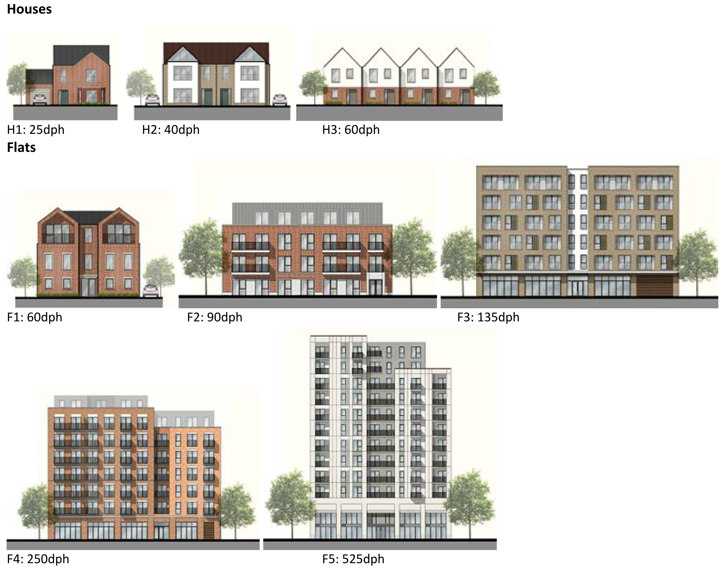
Map 33: Urban Form of Southend Central
Question 3.4.3.2 Southend Central (Urban Form)
Have your say………
Please explain your answers
Question a. Are there development typologies (Figure 22) that you would like to see comes forward in Southend Central? Please explain your answer - you may wish to refer to the different urban forms presented in Map 33 in your response.
Question b. Should a tall buildings policy be introduced to direct such development to specific areas of the neighbourhood? If so, what areas should be identified?
To view our mapping feature showing Urban Forms: Southend-on-Sea Borough Council – Local Plan: Map 2 Urban Forms Map (opus4.co.uk)
3.4.3.3 Employment Land
The retention and provision of employment sites is essential to enable balanced job and housing growth. However, employment land has relatively lower land values compared to residential and therefore it is important to safeguard or allocate sites to facilitate present and future economic growth.
Town centres play an important role in not only providing opportunities in the digital, cultural and creative sector but also providing the opportunity more generally to encourage smaller and more diverse employment activity. A level of professional and business sector growth in particular could be expected to locate in the town centre environments considering their strong link with population clusters, and the level of service, amenities and facilities they provide in one location.
The town centre will remain a major focus for employment particularly in the retail, office, cultural and creative arts sectors, and alongside the central seafront for tourism, food and leisure facilities. It will also continue to thrive as a centre of excellence for education, housing the South Essex College and University of Essex campuses. It will also be a location for niche, flexible office space.
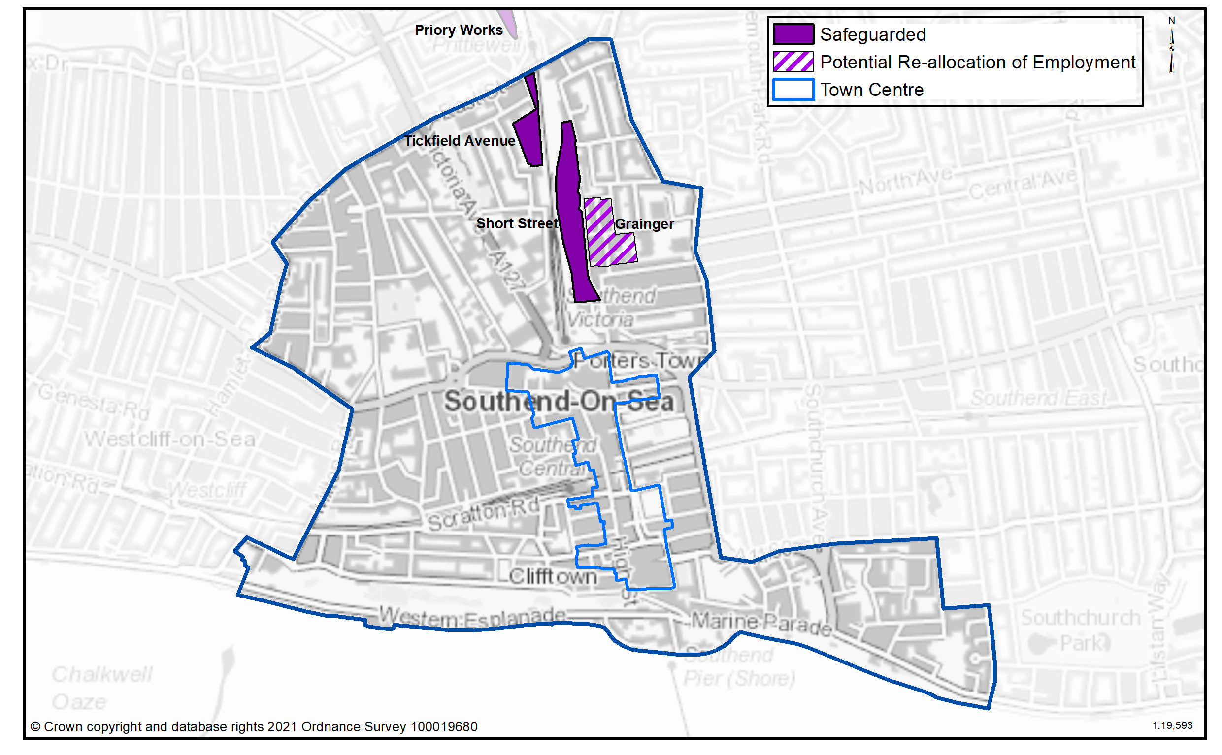
In Southend Central designated employment land is situated in the northern periphery of the area in the Short Street/Kenway area and at Tickfield Avenue. This provides for a range of medium to small valuable business uses providing local employment opportunities. It is proposed that these areas are retained and enhanced (Table 33 and Map 34). However, the Grainger Road area performs poorly as an employment area and is unlikely to attract sufficient occupiers and it is therefore proposed to re-allocate for residential redevelopment (Table 34).
Table 33: Land Use Proposals in Southend town centre and central seafront neighbourhood – Employment Designations
|
Name of Site |
Area (hects.) |
Floorspace (m2) |
|
Short Street/Kenway |
4.03 |
|
|
Land off Tickfield Road |
1.42 |
|
|
Total |
|
|
Table 34: Proposed Re-allocation of Employment Land to Housing Led Use
|
Name of Site |
Area (hects.) |
Floorspace (m2) |
|
Grainger Road |
-2.76 |
|
Map 34: Proposed Employment Designations
Question 3.4.3.3a Southend Central (Employment)
Have your say………
Please explain your answers
Question a - Do you agree that Short Street/ Kenway should be safeguarded as a local employment site?
Question a - Do you agree that Tickfield should be safeguarded as a local employment site?
Question a - Do you agree that Grainger Road employment area should be re-allocated to residential led re-development?
Question 3.4.3.3b Southend Central (Employment)
Question b - Do you have any other comments on employment land provision in Southend Central? If yes, please explain your answer.
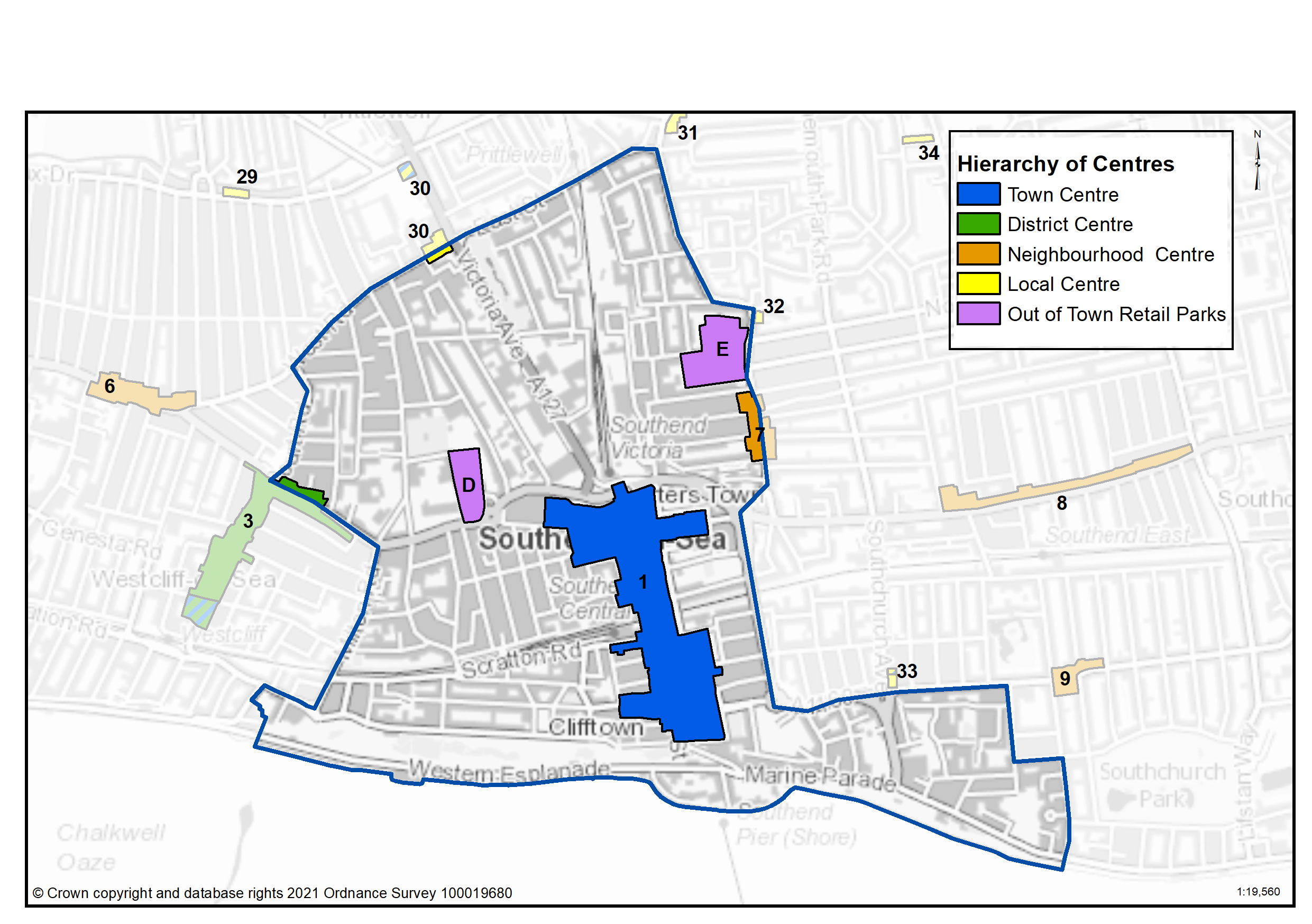
3.4.3.4 Commercial Centres
To ensure the vitality of town centres, the National Planning Policy Framework encourages local planning authorities to implement planning policies and decisions that support the role that town centres play at the heart of local communities, by taking a positive approach to their growth, management, and adaptation.
The Government recently introduced changes to the Use Classes Order which consolidates a wide range of uses including retail, food, financial services, gyms, healthcare, nurseries, offices and light industry into a single use class (Use Class E) and any change of use of a building or land between those uses falling within this Use Class will not require planning permission. It is therefore proposed to define as “Commercial Areas”, centres where we will promote ground floor uses to be within Class E Use Class and encourage improvements to shopfronts and the street scene.
There are a range of commercial centres in the Borough that protect ground floor uses for business purposes (use class E6) and thereby perform a vital function by ensuring communities are served by a range of retail and commercial services. Southend Town Centre lies at the heart of the Borough providing a range of business, educational, retail and leisure facilities. It is focused on two indoor shopping malls connected by a long linear pedestrianised High Street.
There are other commercial centres within Southend Central that provide a vital commercial activity to local residents and these include the Sutton Road Neighbourhood Centre, the local centre at Victoria Avenue and West Street and the London Road and Greyhound retail parks. These are set out in Table 35 and Map 35.
As of August 2021, the Government is also introducing expanded permitted development rights to enable Commercial Uses to be converted to residential without planning permission. Due to this there are limitations on safeguarding ground floor commercial uses within key centres from changing to residential. However, under Article 4 of the General Permitted Development Order a local planning authority can apply to the Secretary of State to withdraw specified permitted development rights across a defined area. The use of Article 4 directions should not be expansive and therefore if we were to use them to restrict ground floor commercial uses from changing to residential, we must focus them to the most important frontages. In reference to Table 35 and Map 35 we are interested in your views on which centres we should investigate for using Article 4 Directions in order to restrict ground floor commercial frontages from being developed to residential under permitted development.
Table 35: Southend Central Commercial Centres
|
Ref |
Name |
Centre Type |
|
1 |
Southend Town Centre |
Town Centre |
|
7 |
Sutton Road South |
Neighbourhood Centre |
|
30 |
Victoria Avenue/ West Street |
Local Centre |
|
D |
London Road Retail Park |
Out of Town Retail Parks |
|
E |
Greyhound Retail Park |
Out of Town Retail Parks |
Map 35: Southend Central Commercial Centres
Question 3.4.3.4a Southend Central (Commercial Centres)
Have your say…….
Please explain your answer
Question a - Should we seek to define Southend Town Centre as a Town Centre as set out in Table 35 to promote a range of commercial uses to serve local community needs and provide local employment opportunities?
Question a - Should we seek to define Sutton Road South as a Neighbourhood Centre as set out in Table 35 to promote a range of commercial uses to serve local community needs and provide local employment opportunities?
Question a - Should we seek to define Victoria Avenue/West Street as a Local Centre as set out in Table 35 to promote a range of commercial uses to serve local community needs and provide local employment opportunities?
Question a - Should we seek to define London Road Retail Park as an Out of Town Retail Park as set out in Table 35 to promote a range of commercial uses to serve local community needs and provide local employment opportunities?
Question a - Should we seek to define Greyhound Retail Park as an Out of Town Retail Park as set out in Table 35 to promote a range of commercial uses to serve local community needs and provide local employment opportunities?
Question 3.4.3.4b Southend Central (Commercial Centres)
Question b - Should we investigate using Article 4 direction to safeguard ground floor commercial uses within the town, district and neighbourhood centres by restricting permitted development changes to residential – if yes, what frontages?
Question 3.4.3.4c Southend Central (Commercial Centres)
Question c - Are there any other areas within the Southend Central Neighbourhood area that we haven’t identified that should be protected for commercial activities? If yes, please explain your answer and let us know where.
3.4.3.5 Green Space - Southend Central
The existing green space and parkland facilities in Southend Central provide a valuable green and open contrast to the dense built urban form. Such areas are essential for healthy living and wellbeing and provide valuable nature habitats. Nevertheless, the Settlement Role and Hierarchy Study7 has shown that despite a small number of parks of good quality and its proximity to the foreshore, Southend Central as a whole, and particularly in and around the High Street is poorly provided for in terms of green infrastructure. This is reflected in the relatively low tree canopy cover in the wards of Victoria, Milton and Kursaal of 9%, 9.7% and 10% respectively, which are some of the lowest in the Borough. The Council’s Tree Policy sets a target to extend the overall tree canopy cover in the Borough from 12% to 15% by 2050. Whilst there are a number of constraints to tree planting within the area including underground services, additional planting will be included wherever opportunities arise. Other urban greening measures including green walls and roofs and rain gardens will also be promoted where appropriate.
National planning policy allows for Local Plans to identify and protect existing green space so it is not built on unless an assessment demonstrates the open space, buildings or land are surplus to requirements; any open space lost would be replaced by equivalent or better provision in terms of quantity, quality and access; or the benefits of new sports and recreation facilities clearly outweigh the loss of the current or former use as open space. In this respect the New Local Plan seeks to protect the existing green spaces as set out in Table 36 and Map 36.
Map 36: Existing Green Space in Southend Central and Proposed New Green Space
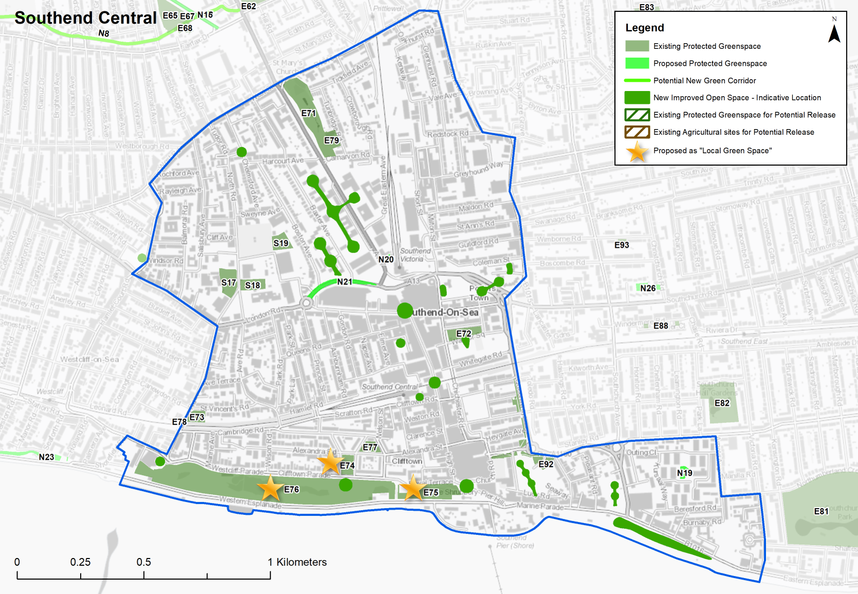
Table 36: Southend Central – Existing Green Space
|
Site Ref. |
Name of Site |
Size (Ha) |
|
Site Ref. |
Name of Site |
Size (Ha) |
|
Local Park |
Playground |
|||||
|
E71 |
Churchill Gardens |
1.915 |
E78 |
Milton Road Gardens Playground |
0.028 |
|
|
E72 |
Warrior Square Gardens |
0.487 |
Sports Ground |
|||
|
E73 |
Milton Road Gardens & Tennis Courts |
0.261 |
E79 |
Southend Bowling Club |
0.341 |
|
|
E74 |
Prittlewell Square |
0.366 |
School |
|||
|
E75 |
The Shrubbery |
1.198 |
S17 |
Milton Hall School Playing Field |
0.637 |
|
|
Local Parks |
S18 |
St Helen's School Playing Field |
0.413 |
|||
|
E76 |
Southend Cliff Gardens |
9.115 |
S19 |
St Mary's School Playing Field |
0.409 |
|
|
Area Open Space |
Crematorium, Graveyard or Cemetry |
|||||
|
E77 |
Alexandra Bowling Green |
0.247 |
C5 |
Prittlewell |
1.626 |
|
|
|
C6 |
St John’s Church |
0.327 |
|||
Table 36a Southend Central - Proposed new green space
Individual sites shown below
Question 3.4.3.5a Southend Central (Green Space)
N19...Kursaal Playground
Playground
Site Ref - N19
Name of Site - Kursaal Playground
Size (Ha) - 0.139
Question a - Do you agree with this proposed new green space designation?
N8...Prittle Brook
Green Corridor
Site Ref - N8
Name of Site - Prittle Brook
Size (Ha) - 4.225m
Question a - Do you agree with this proposed new green space designation?
N20...Central Museum Wildlife Garden
Pocket Park
Site Ref - N20
Name of Site - v
Size (Ha) - 0.048
Question a - Do you agree with this proposed new green space designation?
N21...Queensway Linear Green Space
Linear Green Space
Site Ref - N21
Name of Site - Queensway Linear Green Space
Size (Ha) - 0.478
Question a - Do you agree with this proposed new green space designation?
Question 3.4.3.5b Southend Central (Green Space)
Question b. Do you agree with the indicative locations for additional green infrastructure (Table 37 below and Map 36 above)?
Table 37: Southend Central – Indicative locations for Green Infrastructure provision
|
Site Ref |
Name/ Address |
Type |
Justification |
|
|
CS1.2 Seaways |
Civic Space – linked to food and drink and entertainment uses |
Public realm improvements including soft landscaping elements to increase green infrastructure for climate change resilience and visual amenity and provide functional outdoor space to support business. |
|
|
CS1.3 Marine Plaza |
Pocket Park |
New open space to be provided as part of a mixed use development. |
|
|
Better Queensway |
Pocket Parks as part of comprehensive redevelopment scheme |
3 new pocket parks will include SUDS, play equipment and increase biodiversity within a dense urban area, replacing the existing playground at first floor level. |
|
|
Victoria Circus |
Civic Space and Urban Greening – Improved public realm, landscaping and seating. |
Short Term Scheme. Public realm improvements including soft landscaping elements to increase green infrastructure for climate change resilience and visual amenity. Links with completed public realm improvements to the London Road east of College Way. |
|
|
High Street, north- west side |
Civic Space – Break through High Street to open up The Forum and facilitate the creation of public events space and new museum |
Long Term Scheme. Potential to incorporate urban greening as part of the Elmer Square Phase 2 development |
|
|
Central Railway Station |
Civic Space and Urban Greening – Redevelopment of adjacent land for residential and civic space, including landscaping around station. |
Medium Term Scheme. Public realm improvements including soft landscaping elements to increase green infrastructure for climate change resilience and visual amenity. |
|
|
|
|
|
|
|
High Street |
Rationalisation of highway space to create extensive landscaping |
Short/Medium Term Scheme. Public realm improvements including soft landscaping elements to increase green infrastructure for climate change resilience and visual amenity. |
|
|
Chichester Road |
Rationalisation of road space to create cycle lane and extensive landscaping with links to High Street |
Medium Term Scheme. Public realm improvements including soft landscaping elements to increase green infrastructure for climate change resilience and visual amenity. |
|
|
Royals precinct (top of Pier Hill) |
Civic space – outdoor seating/cafes/landscaping with public events space (linked to scheme 13) |
Medium Term Scheme. There is a long-standing ambition to increase urban greening within the High Street and better connect it with the seafront. |
|
|
Eastern Esplanade |
Civic Space – City Beach Phase 2 – Eastern Esplanade (from the Kursaal to Victoria Road) |
Medium Term Scheme. Public realm improvements including soft landscaping elements to increase green infrastructure for climate change resilience and visual amenity. |
|
|
Western Esplanade |
Civic Space – City Beach Phase 3 – Western Esplanade (from The Pier to Cliffs Pavilion) |
Long Term Scheme. Public realm improvements including soft landscaping elements to increase green infrastructure for climate change resilience and visual amenity. |
Question 3.4.3.5c Southend Central (Green Space)
Question c. Do you agree with Prittlewell Square, Cliff Gardens and the Shrubbery being identified as Local Green Space? If not, can you explain why
Question 3.4.3.5d Southend Central (Green Space)
Question d. Are there any other areas we haven't identified that should be protected or promoted for green infrastructure? If yes, please provide an address and explain why it should be protected/promoted.
Question 3.4.3.5e Southend Central (Green Space)
Question e. Are there other sites within Southend Central that should be designated as Local Green Space? If yes, please provide an address and supporting evidence to outline how the space is special to the local community in terms of beauty, historic significance, recreational value, tranquillity, wildlife or is special to the local community for other reasons.
Question 3.4.3.5f Southend Central (Green Space)
Question f. Do you have any other comments on green space provision in Southend Central? If yes, please explain your answer
Local Green Space
National planning policy allows local authorities to designate land as Local Green Space through their local plans, so that communities can identify and protect green areas of particular importance to them, for example because of its historic significance, recreational value, tranquillity, beauty or richness of its wildlife. Policies for managing Local Green Space are consistent with those for Green Belts.
Prittlewell Square is a formally laid out ornamental garden with historic significance as an integral part of the Clifftown estate and Conservation Area, and benefits from expansive sea views due to its cliff-top setting. Due to its importance as a heritage asset and role as both a visitor attraction and a much loved local park for residents it is proposed to be designated as a Local Green Space. The Shrubbery also forms part of the Clifftown Conservation Area and is an important part of its setting, so it is proposed to also designate this as a Local Green Space (Table 36). The outcome of this consultation will be particularly important in demonstrating that these spaces are special to the community.
Provision of new Green Infrastructure
If Southend Central is to accommodate a substantial increase in residential development and population it will be essential that the existing areas of open space are safeguarded and enhanced principally as places of leisure and relaxation and opportunities to increase provision in the central area actively explored as part of future development schemes (Table 37 and Map 36).
There are two areas of green space not currently designated that are proposed for protection; these are the Central Museum Wildlife Garden (proposed for designation as a pocket park) and the Kursaal playground (Table 36a)
New and enhanced green space, such as pocket parks and play areas, linked to other attractive destinations in and around the Borough will also relieve recreational and development pressures on designated international and European habitat sites, and will form part of a wider South Essex Green and Blue Infrastructure network.
2 Covid-19 would have impacted this most recently - 3 Southend Retail and Leisure Study 2018 – Peter Brett Associates -4 nurseries, primary schools, secondary schools, doctors, dentists, pharmacies, libraries, places of worship, public conveniences, community centres and halls, playing pitches, local equipped play space, amenity greenspace, allotments, natural and semi-natural greenspace, local and neighbourhood centres, town and district centres 5 https://planningpolicy.southend.gov.uk/adoptedplans 6 https://www.legislation.gov.uk/uksi/2020/757/made 7 https://localplan.southend.gov.uk/new-evidence